hudsonvalley21
-
Posts
4,027 -
Joined
-
Last visited
Content Type
Profiles
Blogs
Forums
American Weather
Media Demo
Store
Gallery
Everything posted by hudsonvalley21
-
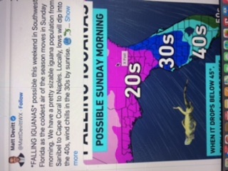
Maybe NWS can create a new advisory for those snowbirds down there.
-
14 here currently. Point and click forecast here is for low of 17.
-
2.5” here. The low got going too late to throw back additional moisture. The radar this afternoon almost looked like we got dry slotted. Mostly all snow up this way. Currently 23/12 edit: dropped off to 19/9 in the last hour.
-
Just starting here. 25/14.
-
That’s colder than Mt. Washingtons low temperature.
-
There is some information and photos of calls on this Facebook account for Orange and Rockland fire.

-
2.53” in the Davis. Draining the pool again. No damage or power loss last night. I’m sure there are some not as lucky as me.
-
2.12” as of 11:00 pm
-
Two Mdt to high impact events NYC subforum; wknd Jan 6-7 Incl OBS, and mid week Jan 9-10 (incl OBS). Total water equiv by 00z/11 general 2", possibly 6" includes snow-ice mainly interior. RVR flood potential increases Jan 10 and beyond. Damaging wind.
hudsonvalley21 replied to wdrag's topic in New York City Metro
A section of Upton’s AFD LONG TERM /TUESDAY THROUGH SUNDAY/... *Key Points* * A significant storm system will impact the region Tuesday night into Wednesday. * Heavy rain, and river and coastal flooding are increasingly likely with this system. See hydrology section below. * Strong winds with the potential for 45 to 60 mph gusts, highest along the coast, Tuesday night into early Wednesday are also possible. A major storm system will impact the area Tuesday night into Wednesday with heavy rain and both river and coastal flooding. Models have been in good overall agreement for sometime now in taking a strengthening low northward across the Midwest and Great Lakes Tuesday into Tuesday night, sending a strong frontal system into the region. Deep-layered lift with the potential for record breaking PWAT values (1.25-1.40"), is setting the stage for heavy rainfall to overspread the area Tuesday afternoon and evening. Rainfall rates for about a 6-h timeframe will be between 0.25 to 0.50 inches, with locally higher rates possible. This will result in a widespread 2 to 4 inches of rainfall with locally higher amounts. A strong SE flow will likely enhance orographic lift for areas west of NYC up into portions of the Lower Hudson Valley and SW CT. NBM probabilities for greater than 2 inches are near 100 percent with much of the area greater than 50 percent for exceeding 3 inches. In addition, snowpack across portions of the area may include up to an inch liquid equivalent. This combined with saturated soils, high streamflow, and low FFG, points to the greatest potential of widespread flooding across NE NJ and the Lower Hudson Valley. WPC also has placed this area under a Moderate Risk of exceeding flash flood guidance. Many of the faster responding streams and rivers across this area will likely go into flood with these forecast rainfall amounts. Several river forecast points are also forecast to reach moderate benchmarks. Thus, a Flood Watch is in effect for these areas. There will likely be refinement and expansion of these areas in coming days. The heaviest rains will then exit the area by daybreak Wednesday with some lingering rain possible as the upper low/trough move through the area. Another potential hazard will be high winds, especially along the coasts with SE gusts of 50 to 60 mph possible. A high wind watch has been issued for LI and may very well need to be expanded to the CT coast in later forecasts. Elsewhere, Wind Advisory level winds are possible elsewhere. At this time, used a blend of the NBM and NBMexp which seemed to best represent the wind and gust potential based on model soundings.- 3,610 replies
-
- 1
-

-
- snow
- heavy rain
- (and 5 more)
-
Two Mdt to high impact events NYC subforum; wknd Jan 6-7 Incl OBS, and mid week Jan 9-10 (incl OBS). Total water equiv by 00z/11 general 2", possibly 6" includes snow-ice mainly interior. RVR flood potential increases Jan 10 and beyond. Damaging wind.
hudsonvalley21 replied to wdrag's topic in New York City Metro
Interesting. Also the southeasterly winds moving up the Hudson River will be increased with the mountain areas such as West Point. Bridge travels across the river areas could be hazardous. -
Two Mdt to high impact events NYC subforum; wknd Jan 6-7 Incl OBS, and mid week Jan 9-10 (incl OBS). Total water equiv by 00z/11 general 2", possibly 6" includes snow-ice mainly interior. RVR flood potential increases Jan 10 and beyond. Damaging wind.
hudsonvalley21 replied to wdrag's topic in New York City Metro
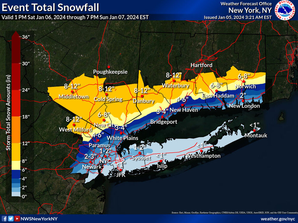
Had around 9” of snow that has compacted down to 5” so far. What also could cause an issue is the bottom of the snowpack is 2” inches of slush due to some melt and the water not being absorbed into the saturated ground. Low temperature in the teens Monday night will freeze the slush so that will also increase the runoff along with the heavy rain and rising temperatures melting the existing snow. -
Two Mdt to high impact events NYC subforum; wknd Jan 6-7 Incl OBS, and mid week Jan 9-10 (incl OBS). Total water equiv by 00z/11 general 2", possibly 6" includes snow-ice mainly interior. RVR flood potential increases Jan 10 and beyond. Damaging wind.
hudsonvalley21 replied to wdrag's topic in New York City Metro
Same here. Starting to taper off now. -
Two Mdt to high impact events NYC subforum; wknd Jan 6-7 Incl OBS, and mid week Jan 9-10 (incl OBS). Total water equiv by 00z/11 general 2", possibly 6" includes snow-ice mainly interior. RVR flood potential increases Jan 10 and beyond. Damaging wind.
hudsonvalley21 replied to wdrag's topic in New York City Metro
The 00z HRRR shows an additional 8”. Maybe another 2”-4” or 3”-5”? -
Two Mdt to high impact events NYC subforum; wknd Jan 6-7 Incl OBS, and mid week Jan 9-10 (incl OBS). Total water equiv by 00z/11 general 2", possibly 6" includes snow-ice mainly interior. RVR flood potential increases Jan 10 and beyond. Damaging wind.
hudsonvalley21 replied to wdrag's topic in New York City Metro
Thinking that too. Especially it’s not 10:1 ratios.- 3,610 replies
-
- 1
-

-
- snow
- heavy rain
- (and 5 more)
-
Two Mdt to high impact events NYC subforum; wknd Jan 6-7 Incl OBS, and mid week Jan 9-10 (incl OBS). Total water equiv by 00z/11 general 2", possibly 6" includes snow-ice mainly interior. RVR flood potential increases Jan 10 and beyond. Damaging wind.
hudsonvalley21 replied to wdrag's topic in New York City Metro
28/28 with heavy snow. 1.5” otg. Super wet snow that compacts to ice immediately when stepped on. Calcium chloride is key for a base. -
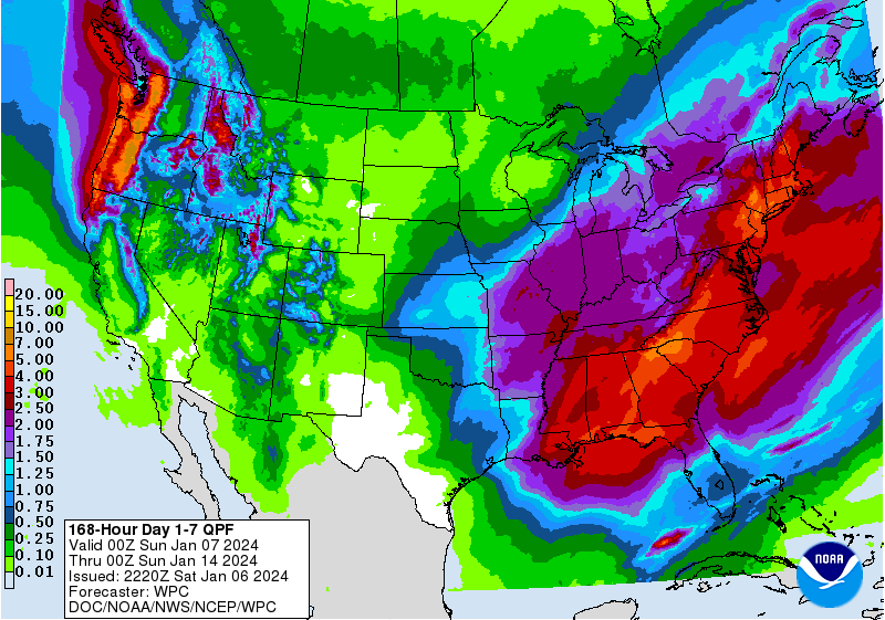
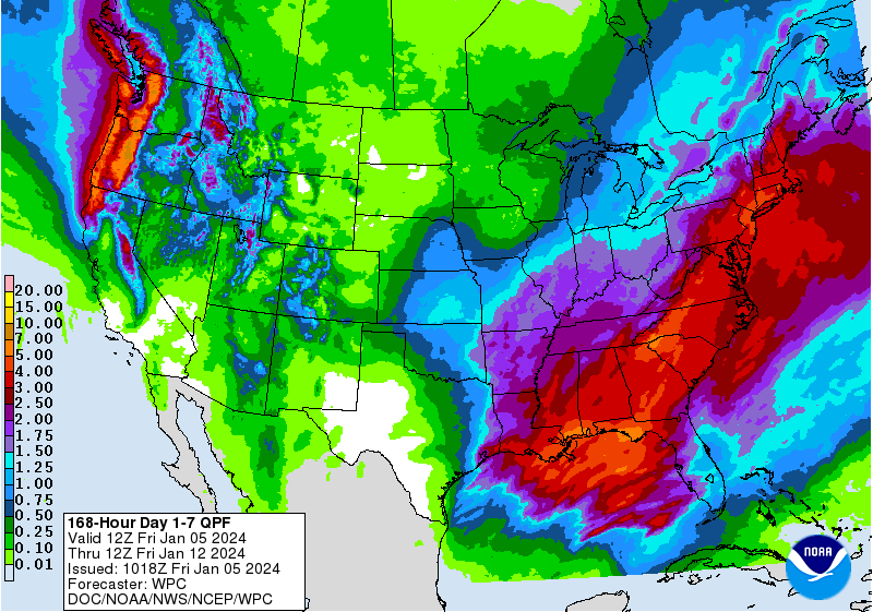
QPF is still concerning for the next week.
-
It basically just picked up in intensity about 15 minutes ago. Coating on all surfaces. 29/28.
-
Two Mdt to high impact events NYC subforum; wknd Jan 6-7 Incl OBS, and mid week Jan 9-10 (incl OBS). Total water equiv by 00z/11 general 2", possibly 6" includes snow-ice mainly interior. RVR flood potential increases Jan 10 and beyond. Damaging wind.
hudsonvalley21 replied to wdrag's topic in New York City Metro
29/28 moderate snow now. Coating on all surfaces. -
Two Mdt to high impact events NYC subforum; wknd Jan 6-7 Incl OBS, and mid week Jan 9-10 (incl OBS). Total water equiv by 00z/11 general 2", possibly 6" includes snow-ice mainly interior. RVR flood potential increases Jan 10 and beyond. Damaging wind.
hudsonvalley21 replied to wdrag's topic in New York City Metro
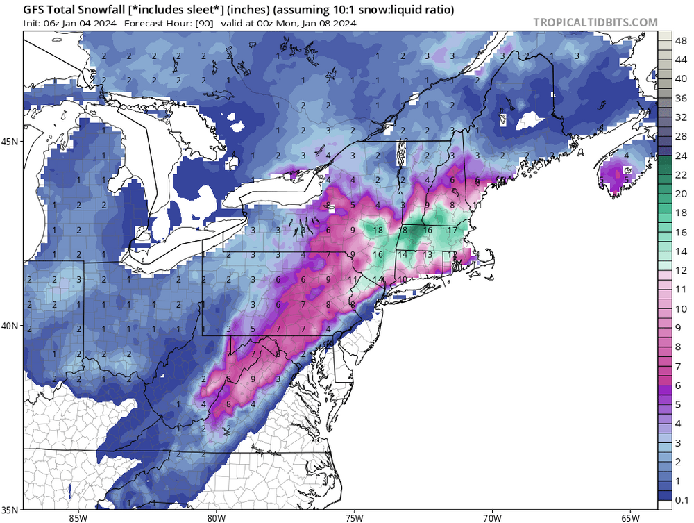
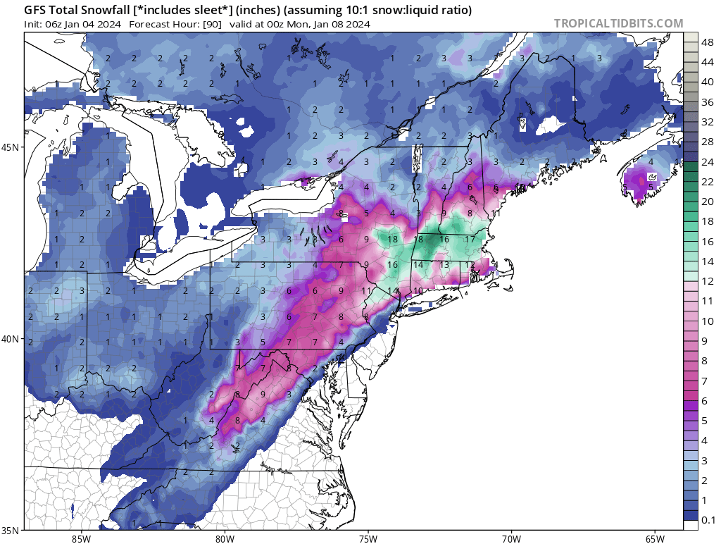
It appears that the short range models have also bumped a little north in the 12z runs. -
Two Mdt to high impact events NYC subforum; wknd Jan 6-7 Incl OBS, and mid week Jan 9-10 (incl OBS). Total water equiv by 00z/11 general 2", possibly 6" includes snow-ice mainly interior. RVR flood potential increases Jan 10 and beyond. Damaging wind.
hudsonvalley21 replied to wdrag's topic in New York City Metro
Most NYPD and FDNY that I know up this way work in the bx- 3,610 replies
-
- 1
-
-
- snow
- heavy rain
- (and 5 more)
-
Two Mdt to high impact events NYC subforum; wknd Jan 6-7 Incl OBS, and mid week Jan 9-10 (incl OBS). Total water equiv by 00z/11 general 2", possibly 6" includes snow-ice mainly interior. RVR flood potential increases Jan 10 and beyond. Damaging wind.
hudsonvalley21 replied to wdrag's topic in New York City Metro
Also a little more QPF -
WPC still bullish with the QPF totals for the next 7days.
-
Rest that heart , it will get a workout soon
-
Hopefully we get enough snow from the 1st event to absorb the rain from the 2nd event to help lower the flooding risk.
-
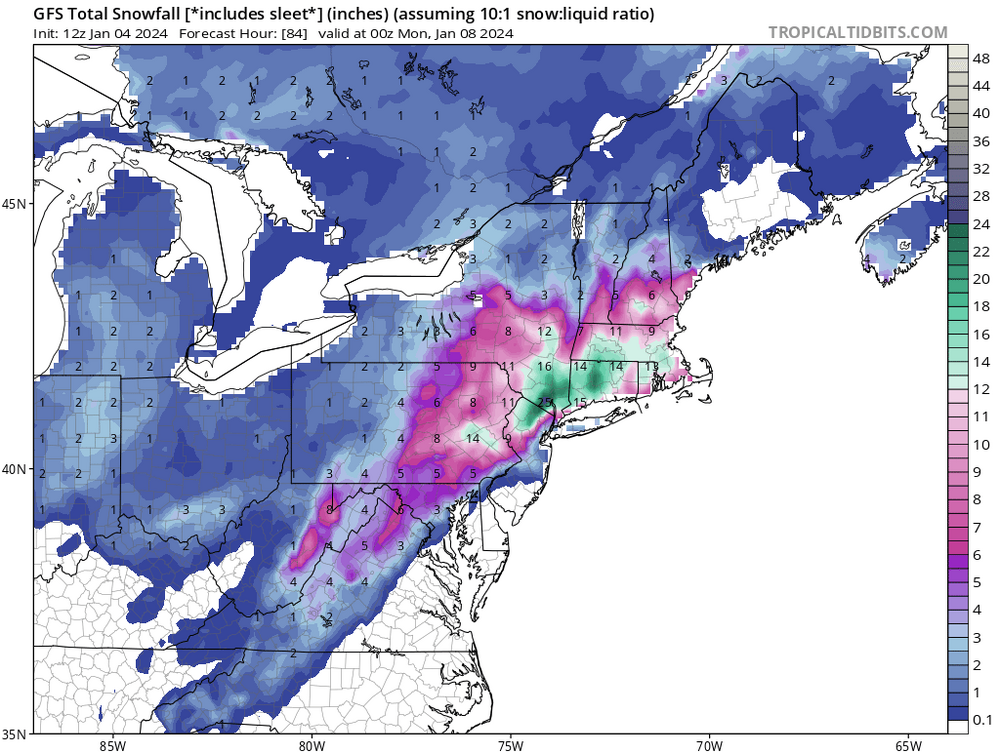
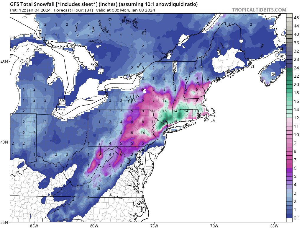
Much more interesting the 12z vs. the 06z. Could be that more sampling has been added. We’ll see what the 18z shows.