

hudsonvalley21
-
Posts
4,072 -
Joined
-
Last visited
Content Type
Profiles
Blogs
Forums
American Weather
Media Demo
Store
Gallery
Posts posted by hudsonvalley21
-
-
3 hours ago, IrishRob17 said:
We went to the Renegades game yesterday and saw those huge patches of a good chunk of the whole valley chewed up.
48 for the low here this morning.
Temps dropped off quickly last night. I was at the Fair oaks drive-in, it was 73 at 8:00 and dropped of to 59 by 11:30. Bottomed out to 54 IMBY.
-
 1
1
-
-
2 hours ago, IrishRob17 said:
That could be the dead ash trees from the emerald ash borer too, I saw a lot of those along that stretch last summer. I was out in western Orange County last weekend and the hillsides along 84 had lots of bare spots from the caterpillars. I’ve heard the New England guys talk about this for a couple years and now I see it in person it’s no joke.
Up to .23” on the day with rain still falling.
0.49” will do it here.
-
39 minutes ago, IrishRob17 said:
Around here the radar is more impressive looking than what's actually falling thus far.
Agree, 0.21” in the bucket from the first line.
-
7 minutes ago, IrishRob17 said:
It started with the smaller trees near me, now there are numerous fully grown huge oaks completely bare. The maples and others are getting chomped up too but at least IMBY the oaks are the worst.
Even looking at Mount Beacon from Newburgh’s water front, there’s large patches completely stripped. Large numbers of those leaf eaters this year.
-
15 hours ago, IrishRob17 said:
Pretty odd looking at trees bare like December in such a high sun angle.
Those suckers had a field day around West Point. A bunch of trees stripped.
-
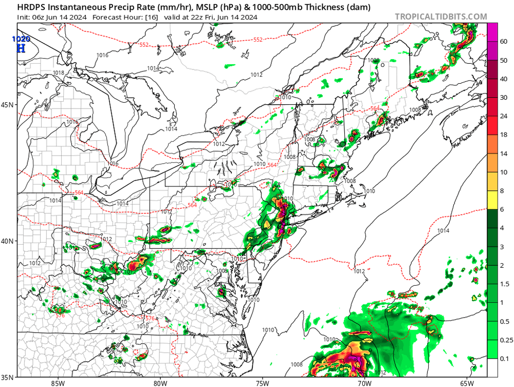
44 minutes ago, weatherwiz said:
This round of showers may end up being too strong and screw things up for later. 3km NAM I think is on that idea happening.
Had a quick shower here around 9am. Still under a heavy cloud deck currently.
-
 1
1
-
-
36 minutes ago, Allsnow said:
Let’s go
And the HRDPS at 5 pm. Most of the other mesoscale models are showing activity at that time. Had a quick shower around 9 am, still a heavy cloud deck up this way currently.
-
3
-
-
On 6/6/2024 at 5:29 PM, Roger Smith said:
Table of forecasts for June 2024
FORECASTER _____________ DCA _ NYC _ BOS __ ORD _ ATL _ IAH __ DEN _ PHX _ SEA
Scotty Lightning ___________+3.0 _ +2.5 _ +2.0 __ +1.5 _ +2.0 _ +2.0 __ +1.5 _ +1.5 _ +1.0
BKViking ___________________+2.2 _ +2.3 _ +1.7 __ +0.8 _ +2.0 _ +3.0 __ +2.5 _ +1.8 _ +1.0
RJay __________ (-2%) ______+2.0 _ +2.0 _ +2.0 __ +2.0 _ +2.0 _ +2.0 __ +2.0 _ +2.0 _ +2.0
rainsucks __________________ +2.0 _ +1.8 _ +1.7 __ +2.4 _ +1.5 _ +2.0 ___ +2.4 _ +1.8 _ +1.3
Rhino16 ____________________+2.0 _ +1.5 _ +1.8 __ +3.0 _ +3.2 _ +2.1 ___ +5.0 _+5.5 _+1.5
Roger Smith _______________ +1.5 _ +1.6 _ +0.9 __ +2.0 _ +2.3 _ +4.0 __ +3.5 _ +2.5 _+1.2
Tom ________________________+1.2 _ +1.3 _ +1.3 __ +0.9 _ +1.3 _ +1.8 ___ +1.7 _ +1.7 _ +0.6
___ Consensus ____________ +1.0 _ +1.3 _ +1.1 __ +1.0 _ +1.4 _ +2.0 ___+1.8 _ +1.8 _ +1.1
hudsonvalley21 ____________ +0.8 _ +1.2 _ +1.1 __ +0.3 _ +1.6 _ +2.2 __ +2.1 _ +1.4 _ +1.5
so_whats_happening ______ +0.6 _ +0.7 _ +0.9 __ +0.5 _ +1.0 _ +1.2 __ +1.5 _ +1.5 _ +1.0
DonSutherland1 ____________+0.5 _ +1.0 _ +1.0 __ +1.0 _ +0.3 _ +1.0 __ +1.2 _ +1.0 _ +0.5
wxallannj ___________________+0.5 _ +0.7 _ +1.0 __ +1.0 _ +0.5 _ +2.3 __ +1.5 _ +2.1 _ +1.5
RodneyS ____________________ 0.0 _ +1.1 _ +0.3 __ -1.8 _ -0.5 _ +0.9 ___ +1.6 _ +0.6 _ +0.6
StormchaserChuck1 ________ 0.0 _ +0.2 _ -0.3 __ -0.5 _ +0.8 _ +1.0 ___ +1.6 _ +1.8 _ +0.7
___ Normal _________________ 0.0 __ 0.0 __ 0.0 ___ 0.0 __ 0.0 __ 0.0 ____0.0 __ 0.0 __ 0.0
wxdude64 __________________-0.8 _-0.2 _ +0.7 __ -0.3 _ -0.4 _ +0.5 ___ +2.1 _ +1.7 _ +2.1
________________________
warmest and coldest forecasts color coded, Normal is colder than all forecasts for IAH, DEN, PHX and SEA
==============
Seasonal max contest
FORECASTER ____________ DCA _ NYC _ BOS __ORD _ATL _IAH __ DEN _PHX _SEA
Scotty Lightning __________ 103 _ 100 __ 98 ____96 __ 104 _ 118 ____ 100 _ 121 __ 92
wxdude64 ________________ 102 _ 102 _ 102 ___ 101 __ 101 _ 106 ____ 104 _ 118 __ 98
Roger Smith _______________102 _ 100 _ 100 ____101 __ 101 _ 109 ____ 104 _ 119 __ 97
rainsucks __________________102 _ 100 __ 99 ___ 104 __ 102 _ 107 ____ 104 _ 120 __99
Rhino16 ____________________101 _ 100 __ 99 ___ 102 __ 102 _ 106 ____ 100 _ 115 __ 98
DonSutherland1 ___________ 101 _ 100 __ 98 ____ 96 ___ 97 _ 104 ____ 101 _ 118 __ 97
___ Consensus _____________101 _ 100 __ 98 ____ 99 ___101 _ 106 ____ 100 _ 119 __ 97
Tom _______________________ 101 __ 98 __ 98 ____ 99 ___102 _ 106 _____ 99 _ 118 __ 96
RJay _______________________ 100 __ 98 _ 100 ___100 __ 101 _ 105 ____ 100 _ 119 __ 95
so_whats_happening ______100 __ 98 __ 97 ____ 95 ___ 99 _ 102 ______98 _ 119 __ 97
RodneyS ___________________99 __ 99 __ 97 _____ 96 ___ 97 _ 102 _____ 99 _ 118 __ 97
wxallannj __________________ 98 __ 98 __ 96 _____ 99 ___ 97 _ 102 ____ 101 _ 120 __ 95
(not entered yet? you can post seasonal max to June 15 _ any of above can also be edited to June 15)
Will add consensus values June 16
Hi Rodger, I added my seasonal maxes. Thanks for all you do!
-
 1
1
-
-
3 hours ago, IrishRob17 said:
0.00 here, did have a very light sprinkle about an hour ago. Heavy chewed leaf and caterpillar poop though.
The Tent Caterpillar showing this year is the largest I’ve seen in the last few years. See a bunch of crabapple trees stripped throughout the area.

The HRRR is showing a few showers moving thru later this afternoon and early evening, hopefully it will wash some of that poop away.
")
-
2 hours ago, IrishRob17 said:
Coldest day in years forecasted here...
Thank goodness I only got 0.04” in the bucket. Saves me from shoveling the driveway

-
 1
1
-
-
0.04” here.
-
10 hours ago, gravitylover said:
.7
0.86 here.
-
DCA: +0.8 101
NYC: +1.2 101
BOS: +1.1 99
ORD: +0.3. 95
ATL: +1.6 98
IAH: +2.2. 103
DEN: +2.1 100
PHX: +1.4 119
SEA: +1.5 98 -
4 hours ago, IrishRob17 said:
I knew that cell went through Greenwood Lake but I didn't realize it was that bad. I do now after looking at the fire calls from this morning, at least one tree on a car and numerous trees on houses I saw after taking a quick glance. I dont recall seeing a request for that many UTVs before for something other than a brush fire.
Orange County NY Fire Calls
Mutual Aid:
Monroe Fire - UTV
Warwick Fire - UTV
Chester Fire - UTV
Tuxedo Fire - UTV
Florida Fire - UTV (Unable to Crew)
South Blooming Grove Fire - UTV
Pine Island Fire - UTV
Woodbury Fire - UTV
Goshen Fire - UTV (Unable to Crew)
Cronomer Valley Fire - UTV
New Hampton Fire - UTV (Unable to Crew)
Salisbury Mills Fire - UTV
Johnson Fire - UTV
Sloatsburg Fire - 1 Engine to Standby
36-1
36-3
36-15
36-16
Orange County Field Comm
-
47 minutes ago, IrishRob17 said:
Just some light rain up here for the most part but there was one bolt of lightning that must have hit the tower at the top of the hill because the flash and crashing boom were at essentially the same time. It got my plague flowing for sure.
Just some light rain and a few rumbles here with the first cell. It was a little rowdy in the Greenwood Lake area with some trees down, this one slid just to our south. We’ll see what happens with the second round of activity that’s on our doorstep.
-
7 minutes ago, psv88 said:
Should be fun on the fishing boat in thunderstorms with 60 10 year olds!
Hopefully they check the radar before heading out.
-
1
-
-
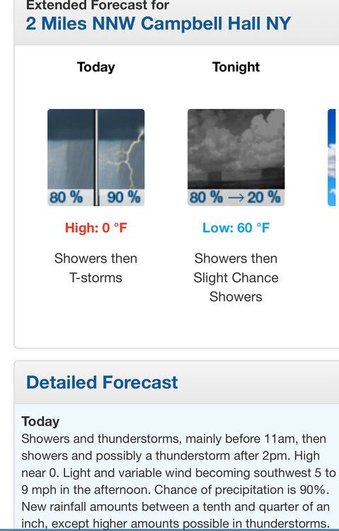
1 hour ago, Allsnow said:
Storms tomorrow morning?
Upton’s thoughts, a section of their AFD below,
Area Forecast Discussion National Weather Service New York NY 802 PM EDT Wed May 22
Some showers and thunderstorms have fired up west of the area along and ahead of a pre frontal trough. Some of this activity could make it into western portions of the area overnight, mainly north and west of NYC, but is not expected to be severe with a lack of shear. The better chances for showers and thunderstorms for our area will be as the cold front starts to slowly move through the area Thursday morning. PoPs have trended earlier in the day with a shift in timing in the 12z CAMs. Given the environment, with MLCAPE values around 1000-1500 J/kg and 0-6 km shear increasing to around 35-40 kt, some storms could become strong to severe. The SPC continues to outline the area in a "marginal" risk of severe weather, with large hail and damaging winds being the main threat. Given the high pwats, any thunderstorms could also produce heavy downpours. At this time, there are no flooding concerns. Given the activity in the morning, it will be difficult to destabilize again for the afternoon and we will likely see just lingering showers as the front continues to sag through the area. However, if we end up seeing less or no activity in the morning, the stronger showers/thunderstorms could be in the afternoon. For this reason, have left chance of thunder through the day Thursday.
-
2
-
-
54 minutes ago, bluewave said:
The HRRR has convection with a MCV.

There’s a small line currently in eastern Pa that is around 2 hours out. Maybe it could hold together somewhat.
-
1 hour ago, bluewave said:
Just enough SE flow at Newark today so POU was warmer for a 2nd day in a row.
THE POUGHKEEPSIE NY CLIMATE SUMMARY FOR MAY 22 2024...
VALID TODAY AS OF 0400 PM LOCAL TIME.

CLIMATE NORMAL PERIOD: 1991 TO 2020
CLIMATE RECORD PERIOD: 1931 TO 2024


WEATHER ITEM   OBSERVED TIME   RECORD YEAR NORMAL DEPARTURE LAST
                VALUE   (LST)  VALUE       VALUE  FROM      YEAR
                                                  NORMAL
...................................................................
TEMPERATURE (F)
 TODAY
  MAXIMUM         89   2:37 PM  98    1941  73     16       77
  MINIMUM         58   5:00 AM  31    2002  50      8       45
  AVERAGE         74                        61     13       61
THE NEWARK NJ CLIMATE SUMMARY FOR MAY 22 2024... VALID TODAY AS OF 0400 PM LOCAL TIME. CLIMATE NORMAL PERIOD 1991 TO 2020 CLIMATE RECORD PERIOD 1931 TO 2024 WEATHER ITEM OBSERVED TIME RECORD YEAR NORMAL DEPARTURE LAST VALUE (LST) VALUE VALUE FROM YEAR NORMAL ................................................................... TEMPERATURE (F) TODAY MAXIMUM 87 1241 PM 98 1992 74 13 78 MINIMUM 64 457 AM 44 1957 56 8 56 2002 AVERAGE 76 65 11 6787.8 was the high for the 2nd day in a row at KSWF.
-
1
-
-
13 minutes ago, bluewave said:
Just enough SE flow today for POU to beat EWR.
THE POUGHKEEPSIE NY CLIMATE SUMMARY FOR MAY 21 2024...
VALID TODAY AS OF 0400 PM LOCAL TIME.

CLIMATE NORMAL PERIOD: 1991 TO 2020
CLIMATE RECORD PERIOD: 1931 TO 2024


WEATHER ITEM   OBSERVED TIME   RECORD YEAR NORMAL DEPARTURE LAST
                VALUE   (LST)  VALUE       VALUE  FROM      YEAR
                                                  NORMAL
...................................................................
TEMPERATURE (F)
 TODAY
  MAXIMUM         88   2:57 PM  95    1941  73     15       71
                                      1996
  MINIMUM         57   5:00 AM  29    2002  49      8       49
  AVERAGE         73                        61     12       60
THE NEWARK NJ CLIMATE SUMMARY FOR MAY 21 2024... VALID TODAY AS OF 0400 PM LOCAL TIME. CLIMATE NORMAL PERIOD 1991 TO 2020 CLIMATE RECORD PERIOD 1931 TO 2024 WEATHER ITEM OBSERVED TIME RECORD YEAR NORMAL DEPARTURE LAST VALUE (LST) VALUE VALUE FROM YEAR NORMAL ................................................................... TEMPERATURE (F) TODAY MAXIMUM 87 244 PM 96 1996 74 13 75 MINIMUM 58 514 AM 42 1950 55 3 57 2002 AVERAGE 73 65 8 6687.8 was the official high temperature at KSWF.
-
On 5/15/2024 at 9:11 AM, IrishRob17 said:
Good morning, is there anybody alive out there?! Up to .52" for this event. 2.70" for the month so its looking like another above normal month here. My son got married at Notre Dame on 5/4/24, a fantastic weekend all around! The weather turned out great out there that day. My son and daughter-in-law are doing it again this Sunday in NJ for all friends and family (Notre Dame was a relatively small affair). Hoping the rain gets out of here by Sunday afternoon.
Congratulations and best wishes for your family!

-
1
-
-
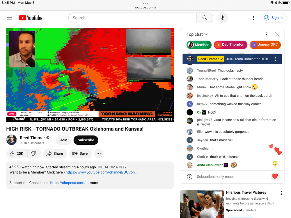
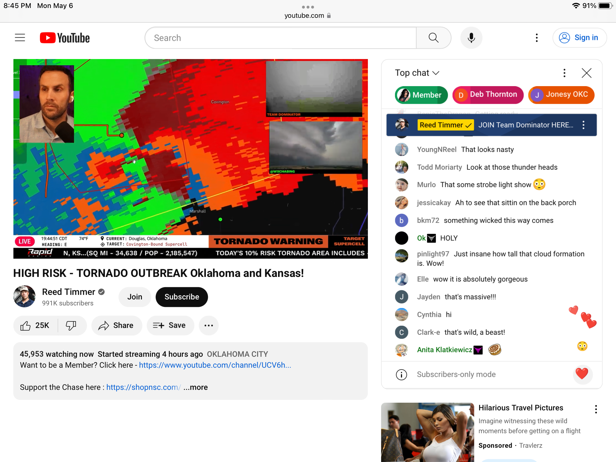
42 minutes ago, weatherwiz said:
oof

Here is a YouTube live storm chasing site

-
1
-
-
9 minutes ago, Poker2015 said:
Any good livestreams?
-
1
-
-
DCA _ NYC _ BOS __ ORD _ ATL _ IAH __ DEN _ PHX _ SEA
0.9 1.0 1.8 2.2 1.3 1.4 0.8 0.3 1.2


Interior NW & NE Burbs 2024
in New York City Metro
Posted
You might sweat more")