hudsonvalley21
-
Posts
4,027 -
Joined
-
Last visited
Content Type
Profiles
Blogs
Forums
American Weather
Media Demo
Store
Gallery
Everything posted by hudsonvalley21
-
Well at least were in the same state URGENT - WINTER WEATHER MESSAGE National Weather Service Buffalo NY 1258 PM EST Wed Feb 26 2020 NYZ006>008-270200- /O.UPG.KBUF.LE.W.0004.200227T1200Z-200229T2300Z/ /O.NEW.KBUF.BZ.W.0001.200227T1200Z-200228T2100Z/ Oswego-Jefferson-Lewis- Including the cities of Oswego, Watertown, and Lowville 1258 PM EST Wed Feb 26 2020 ...BLIZZARD WARNING IN EFFECT FROM 7 AM THURSDAY TO 4 PM EST FRIDAY... * WHAT...Blizzard conditions expected. Total snow accumulations of 3 to 4 feet across the Tug Hill Plateau, and 1 to 2 feet for surrounding lower elevations. Winds gusting as high as 50 to 60 mph will result in severe blowing and drifting snow. * WHERE...The Eastern Lake Ontario Region.
-
We’ll see. The second teaser is a slow mover and is staying to the south and OTS. Let’s see if the boy who called wolf cried one to many times.
-
Our area is in the jackpot zone for tomorrow.

-
February 2020 General Discussions & Observations Thread
hudsonvalley21 replied to Rtd208's topic in New York City Metro
All rain here 38/34 currently. Elevation 125' -
Currently 41/27 here. It will be a nice thump of rain. Upton is optimistic tho. Area Forecast Discussion National Weather Service New York NY 727 PM EST Wed Feb 12 2020 NEAR TERM /THROUGH THURSDAY/... Updated the forecast to delay the timing of PCPN onset. Still some dry air to overcome before it reaches the ground. Also added the mention of a chance of sleet mixing in wherever PCPN begins as rain based on thermal profiles aloft, anticipating a cooling of the column as it saturates. A warm front will approach from the southwest tonight. Isentropic lift along and ahead of the boundary will allow clouds to increase, lower, and thicken. Weak low pressure over Louisiana as of 18Z will ride along this boundary and track toward the area. Light precipitation is expected after 00Z, with chances for precipitation increasing from west to east overnight. The best chances for precipitation look to be between 1 am and 7 am Thursday, this is when lift would be the greatest across the area, with the warm front just to our south and the low to the southwest somewhere over or near Pennsylvania. Therefore, maturate to perhaps briefly heavy precipitation is possible during this time frame. As for precipitation type, plain rain is expected across Long Island, New York City, and much of northeast New Jersey and coastal southern Connecticut. Precipitation may start off as all snow across portions of the interior, such as northern portions of the Lower Hudson Valley, and inland southwest Connecticut. The all snow line may head south a few miles due to dry air in the lower levels leading to column cooling. A wintry mix, mainly of rain and snow, can be expected between these locations. Isolated areas may see some sleet mix in and freezing rain, but again, this will be patchy in nature, and an SPS may be issued later tonight to cover this possibility for inland areas. Strong southwest winds aloft will bring in warmer air rather quickly, with almost the entire forecast area changing over to plain rain a few hours after midnight tonight, with any patchy areas of freezing rain or wintry mix that remain in the far interior or higher elevations changing to plain rain by daybreak Thursday. As for snowfall totals, northern Orange county may see between 1 and 2 inches, while isolated areas such as the higher elevations may see these amounts as well. Elsewhere, under an inch is expected before the changeover.
-
Could be, currently sitting at 28 here.
-
February 2020 General Discussions & Observations Thread
hudsonvalley21 replied to Rtd208's topic in New York City Metro
Same here. Nice to see -
Beautiful pics. I’m jealous. You missed the action here today, got a dusting in snow showers Enjoy up there
-
February 2020 General Discussions & Observations Thread
hudsonvalley21 replied to Rtd208's topic in New York City Metro
Currently 33/19. a section of Upton’s AFD below for some frozen types tonight. NEAR TERM /UNTIL 6 AM THURSDAY MORNING/... Forecast is generally on track. Precipitation currently over the Delmarva peninsula will make its way into the forecast area around midnight, with some scattered precipitation moving in beforehand. Pushed back the slight chance POPs about an hour later than previously forecast based on mesoscale guidance. Also, dew points are lower than previously forecast. Will have to monitor how they progress over the next couple of hours for possibility of brief wintry mix where rain is currently forecast for the onset of the precipitation. Winter weather advisories remain in effect for portions of interior NE NJ, the Lower Hudson Valley, and interior souther CT for a period of freezing rain late tonight into Friday morning. -
February 2020 General Discussions & Observations Thread
hudsonvalley21 replied to Rtd208's topic in New York City Metro

-

-
Here’s some disco threads

-
DCA +2.6 NYC +2.5 BOS +2.4 ORD -0.5 ATL +2.4 IAH +1.7 DEN -1.1 PHX -0.9 SEA -1.4
-
Enjoy the warmth and have a safe trip
-
0.94 here.
-
977mb is definitely some eye candy
-
January 2020 General Discussions & Observations Thread
hudsonvalley21 replied to Rtd208's topic in New York City Metro
Not for Ohio -
Don’t let a little rain stop you.

-
You could move up you travel days one day sooner if that’s possible. As wdrag just posted, you could have some issues in the higher elevation areas along your route. You looking at around an inch of QPF for the event and it’s still not locked in on what types will occur especially along that route that is so elevation varying.
-
Thanks
-
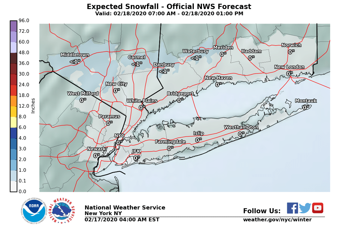
Can you please give the snow amounts for the KSWF area. I don’t have access to the maps and think that we can’t post them here. Thanks
-
It will shift around and we have plenty of time to watch for trends.
-
3.1 will do it here. Have to say the models had a good call on this one for a few days.
-
2.3” OTG 24/22 moderate snow
-
Yup just after making the last post it started up again and the temperature also dropped 1 degree. Another quick 1/3” in a half an hour.