hudsonvalley21
-
Posts
4,027 -
Joined
-
Last visited
Content Type
Profiles
Blogs
Forums
American Weather
Media Demo
Store
Gallery
Everything posted by hudsonvalley21
-
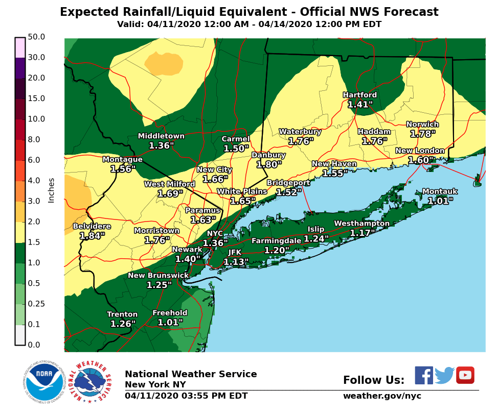
All liquid here 37 currently.
-
That’s if they don’t beat you to the rabbits. Plenty of snowshoes here, Chinese takeout place closed the last couple of weeks due to the virus.

-
-
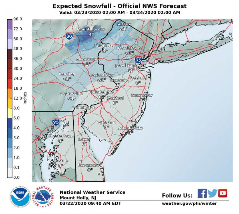
How much for Philly
-
Just got power back up, it was down for about an hour and a half. A little lull in the winds currently. Winds were sustained around 20 mph had frequent gusts in the 40’s. Highest gust recorded on the Davis so far is 48. 63/57
-
Their discussion for our area below, Virginia through central and eastern Pennsylvania and New Jersey... Have expanded the SLGT risk farther north into this region. Areas of rain and thunderstorms will likely be ongoing north of a warm front from PA and NJ into southern New England. This activity will shift northeast during the morning allowing modest destabilization to occur in the pre-frontal warm sector with MLCAPE from 400-800 J/kg. Storms are expected to redevelop along cold front and in association with deeper forcing accompanying the northeast-ejecting shortwave trough. Wind profiles with 50+ kt effective bulk shear along with large 0-1 km hodographs will promote a threat for organized storms including supercells capable of damaging wind and a couple of tornadoes.
-
Good to hear you’re moving in the right direction
-
Same here
-
Wow, I haven’t heard of that condition before. Wishing her well and speedy recovery. Hope all is well with you Rjay.
-
Glad to hear the tests came back negative . Hopefully tomorrow will be nicer weather to get out for a walk or a ride on the bike cycle.
-
Good to hear your both feeling alright. Thoughts and prayers for you both and your tests coming back negative.
-
April 2020 temperature forecast contest
hudsonvalley21 replied to Roger Smith's topic in Weather Forecasting and Discussion
DCA +0.9 NYC +0.8 BOS +0.7 ORD +0.3 ATL +0.9 IAH +0.7 DEN +0.3 PHX -0.1 SEA -0.4 -
Interior burbs - late season snow 22nd/23rd
hudsonvalley21 replied to Animal's topic in New York City Metro
Changing back to sleet here. Another coating of ice pellets in the last hour. Temp down to 32. It’s looking like the temps are busting on the low side. -
Interior burbs - late season snow 22nd/23rd
hudsonvalley21 replied to Animal's topic in New York City Metro
The yard raking you did the other day jinxed it. -
Interior burbs - late season snow 22nd/23rd
hudsonvalley21 replied to Animal's topic in New York City Metro
Flipping back and forth between ice pellets and snow currently. Large flakes and pellets. Ground is covered along with the roadway with grapple. 34 degerees edit, now all moderate snow. -
Interior burbs - late season snow 22nd/23rd
hudsonvalley21 replied to Animal's topic in New York City Metro

-
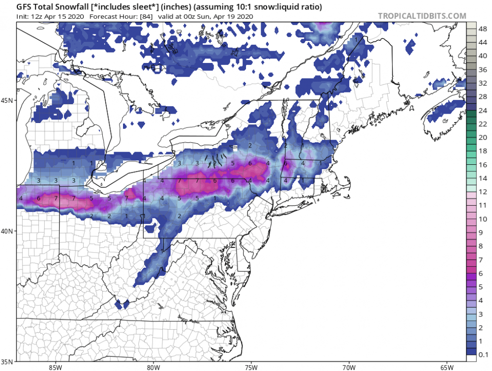
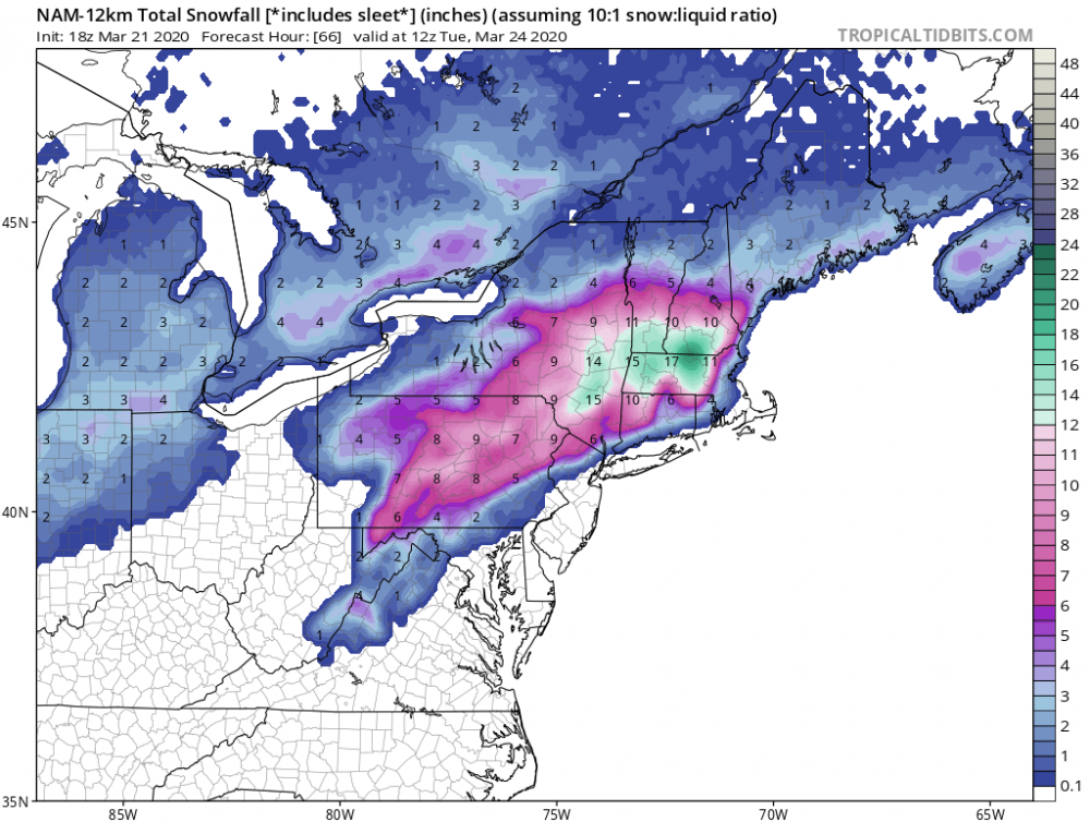
That should be enough to jinx it. I was going to put my snowblower away and open up the pool here is today’s 18z silly NAM
-
Something to track over the next few days!
-
Something to watch instead of sports re-runs. We’ll see, stay healthy!
-
We’ll see how it unfolds. It will be like threading a needle at this time of the season. Plenty of model runs before this event.
-
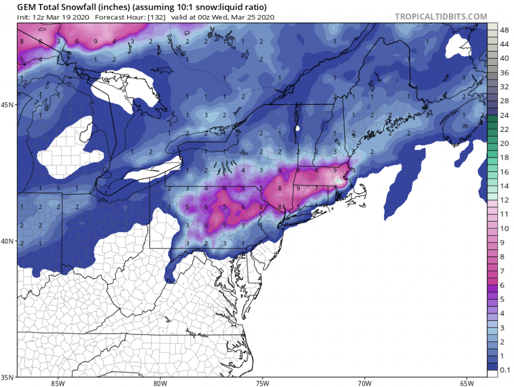
Here is the GEM thru 132 hours for the first event. Pretty much in line with the euro and GFS.
-
Wonder if that fire was caused by a “hotbox” (rail car issue along the train tracks) the top photo shows a long line of small fires along the train tracks in the fires early stages.
-
March 2020 Temperature Forecast Contest
hudsonvalley21 replied to Roger Smith's topic in Weather Forecasting and Discussion
DCA +3.4 NYC +3.6 BOS +3.5 ORD +3.7 ATL +1.8 IAH +1.7 DEN +0.6 PHX -0.2 SEA +0.3