hudsonvalley21
-
Posts
4,027 -
Joined
-
Last visited
Content Type
Profiles
Blogs
Forums
American Weather
Media Demo
Store
Gallery
Everything posted by hudsonvalley21
-
May 2020 General Discussions & Observations Thread
hudsonvalley21 replied to Rtd208's topic in New York City Metro
SPC shifted the enhanced risk area to the northwest and put our area in the slight risk Category. SPC AC 151255 Day 1 Convective Outlook NWS Storm Prediction Center Norman OK 0755 AM CDT Fri May 15 2020 Valid 151300Z - 161200Z Northeast States... Overall change from the 06Z outlook is minimal with concerns over the amplitude of boundary-layer moistening depicted in latest guidance. A shortwave trough over Lake Superior will translate east into Maine by early Saturday. Attendant mid-level speed max is progged to amplify with 500-mb flow in excess of 50 kt overspreading much of NY and northern New England by peak heating. Surface cyclone should diurnally deepen as it reaches the NY/VT border area around 21Z. Surface temperatures should warm through the 70s and low 80s south of the cyclone, ahead of an impinging cold front. While low-level moistening is underway, the bulk of guidance may be too aggressive with depiction of warm-sector dew points in the low 60s. Nevertheless, enlarged low-level hodographs should favor a few supercells developing from central NY and spreading towards southern VT/NH and western MA. Modest mid-level lapse rates will likely curtail significant severe potential. -
May 2020 General Discussions & Observations Thread
hudsonvalley21 replied to Rtd208's topic in New York City Metro
-
Classic
-
Missed here too. Fell apart.
-
cold wave and interior snow threat 5/8
hudsonvalley21 replied to forkyfork's topic in New York City Metro
Special Weather Statement National Weather Service New York NY 645 PM EDT Sat May 9 2020 CTZ005>012-NYZ067-068-070-092345- Southern Middlesex-Northern Fairfield-Southern New London-Southern Fairfield-Northern New London-Northern New Haven-Northern Middlesex-Southern New Haven-Putnam-Northern Westchester-Orange- 645 PM EDT Sat May 9 2020 ...FAST MOVING BANDS OF SNOW SQUALLS WILL AFFECT PORTIONS OF THE LOWER HUDSON VALLEY AND SOUTHERN CONNECTICUT... At 640 PM EDT, National Weather Service Doppler radar showed bands of snow squalls extending from Bristol to New Fairfield to near Kerhonkson to Maplewood to Gibson. Movement was southeast at 50 mph. Winds up to 45 mph and visibilities 1/4 to 1/2 mile are likely with the heavier squalls. These squalls will be near... Cheshire and Bethel around 645 PM EDT. Newtown around 650 PM EDT. Meriden and Middletown around 655 PM EDT. Bridgeport and Middletown around 705 PM EDT. Shelton and East Hampton around 710 PM EDT. New Haven and Milford around 715 PM EDT. Chester around 720 PM EDT. Brewster and Carmel around 730 PM EDT. Cold Spring and West Point around 735 PM EDT. -
Special Weather Statement National Weather Service New York NY 645 PM EDT Sat May 9 2020 CTZ005>012-NYZ067-068-070-092345- Southern Middlesex-Northern Fairfield-Southern New London-Southern Fairfield-Northern New London-Northern New Haven-Northern Middlesex-Southern New Haven-Putnam-Northern Westchester-Orange- 645 PM EDT Sat May 9 2020 ...FAST MOVING BANDS OF SNOW SQUALLS WILL AFFECT PORTIONS OF THE LOWER HUDSON VALLEY AND SOUTHERN CONNECTICUT... At 640 PM EDT, National Weather Service Doppler radar showed bands of snow squalls extending from Bristol to New Fairfield to near Kerhonkson to Maplewood to Gibson. Movement was southeast at 50 mph. Winds up to 45 mph and visibilities 1/4 to 1/2 mile are likely with the heavier squalls. These squalls will be near... Cheshire and Bethel around 645 PM EDT. Newtown around 650 PM EDT. Meriden and Middletown around 655 PM EDT. Bridgeport and Middletown around 705 PM EDT. Shelton and East Hampton around 710 PM EDT. New Haven and Milford around 715 PM EDT. Chester around 720 PM EDT. Brewster and Carmel around 730 PM EDT. Cold Spring and West Point around 735 PM EDT.
-
Nice snow squall to our northwest. Let’s see if it holds together. Special Weather Statement National Weather Service Binghamton NY 344 PM EDT Sat May 9 2020 NYZ009-015>018-022>025-036-037-044>046-055>057-062-PAZ038>040- 100000- Northern Oneida-Yates-Seneca-Southern Cayuga-Onondaga-Steuben- Schuyler-Chemung-Tompkins-Madison-Southern Oneida-Cortland- Chenango-Otsego-Tioga-Broome-Delaware-Sullivan-Bradford- Susquehanna-Northern Wayne- 344 PM EDT Sat May 9 2020 ...HEAVY SNOW SHOWERS EXPECTED THROUGH THIS EVENING... Scattered heavy snow showers will continue through this evening. Localized accumulations of 1 to 3 inches will be possible across higher terrain, with a coating of snow possible at lower elevations. In addition, heavy snow squalls will cause rapidly changing travel conditions with visibility less than a quarter mile and slippery spots on roads.
-
cold wave and interior snow threat 5/8
hudsonvalley21 replied to forkyfork's topic in New York City Metro
42/39 currently, 0.40 in the rain gauge so far. All liquid. -
BxEngine will be parked around the corner from you with the heat on high and the windows open. This model has that factored in
-
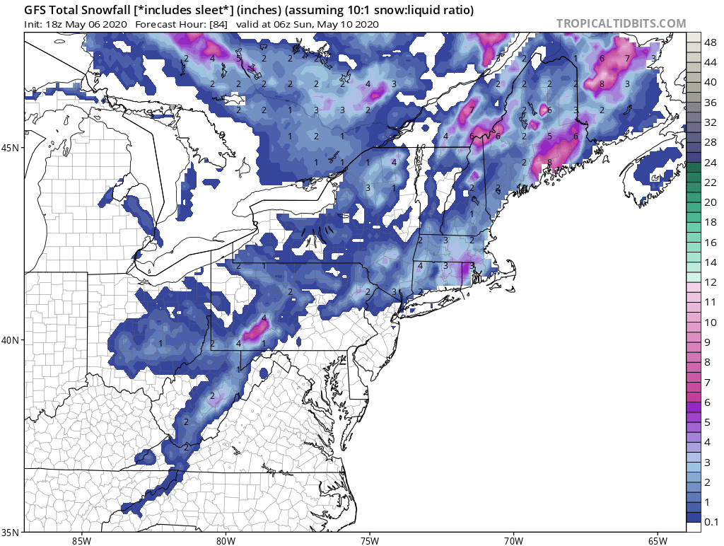
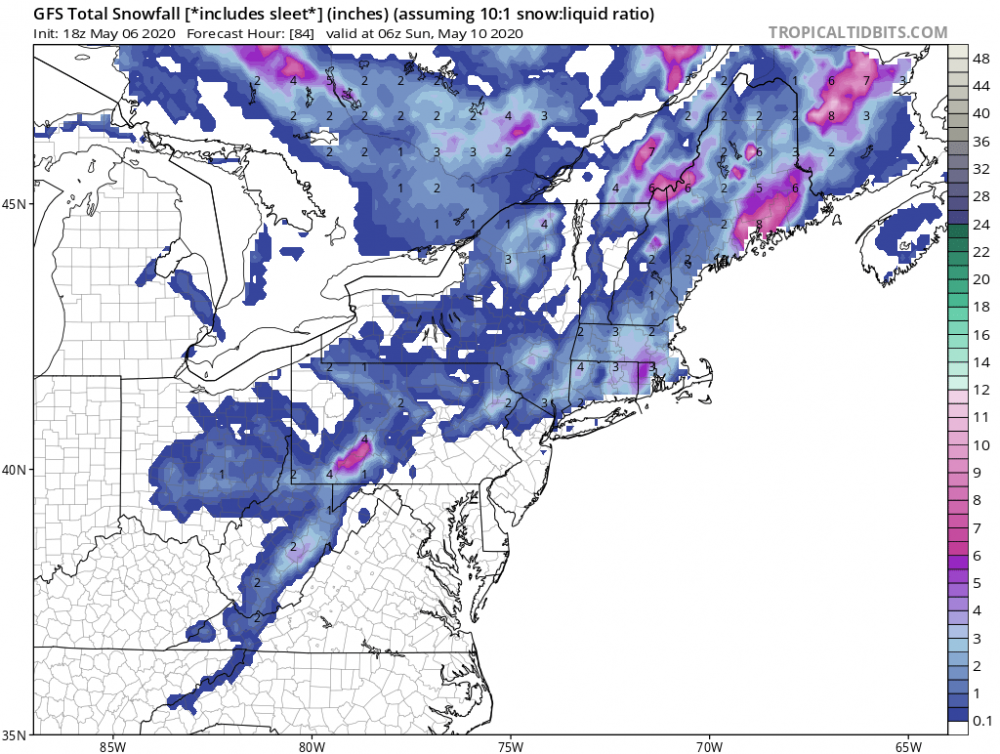
Might as well put this map too. Let’s go all in.
-
May 2020 General Discussions & Observations Thread
hudsonvalley21 replied to Rtd208's topic in New York City Metro
Maybe they could add a few more languages to the signs. It could be that these pictured future world leaders aren’t familiar with the languages that are posted. -
A very noticeable change from 24 hours ago, currently 49 degrees and a wind steady around 20 mph. This time yesterday 73 degrees.
-
1.22 in the Davis for the event.
-
1.22 in the bucket for the event.
-
May 2020 temperature forecast contest
hudsonvalley21 replied to Roger Smith's topic in Weather Forecasting and Discussion
DCA -0.7 NYC -0.8 BOS -0.9 ORD -1.2 ATL + 0.9 IAH +1.4 DEN +1.7 PHX +2.5 SEA +1.3 -
Light showers up this way so far. 0.15 In the bucket as of now. 47/46
-
Currently 43/42 here with 0.17 in the bucket so far today
-
Radar looks light for the NYC metro area currently. Below is Upton’s thoughts. Area Forecast Discussion National Weather Service New York NY 1048 AM EDT Sun Apr 26 2020 .SYNOPSIS... Low pressure impacts the region today through Monday. High pressure then briefly builds in for Tuesday. A frontal system approaches Wednesday night and will affect the region through Thursday night, and possibly the first half of Friday. && .NEAR TERM /UNTIL 6 PM THIS EVENING/... Dry air in the low levels as noted on the 12Z KOKX sounding keeping precipitation light and scattered thus far. Surface dewpoint depressions are on the rise, but bulk of the precipitation remains southeast of the area. Short term CAMs are suggesting some potential for thunder later in the afternoon than originally forecast, and so updates have been made reflecting this. Surface low pressure over the Ohio Valley will track eastward today while a secondary low develops near the Mid-Atlantic coast. This low will become the primary low and track just south us tonight into Monday. Expect periods of rain today. Rain starts off mostly on the lighter side. More intense rainfall, mostly moderate, starts in the second half of this morning and lasts through the first half of the afternoon as models have trended drier in the mid levels during the late afternoon and evening hours. This moderate rainfall will coincide with the strongest thermal and llj forcing, synoptic lift from upper jet streak dynamics, and deepest moisture available as an H8 theta-e ridge shifts through. The mid-level drying casts more doubt on the chances of an afternoon thunderstorm as mid-level lapse rates steepen and elevated instability shifts through, but the strongest overall lift is exiting. Will still leave in a slight chance of thunder and the potential for at least moderate rainfall for the entire afternoon as confidence is not high enough to remove the mention completely. It`ll be breezy, particularly for coastal sections with an E-NE flow. High temperatures will be well below normal.
-
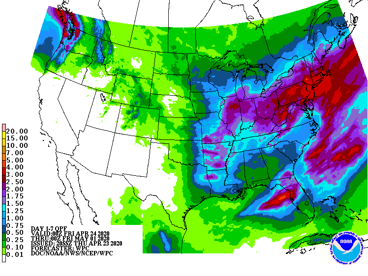
And next Thursday too. Pretty wet 7 day QPF map.
-
Same here, the furry little rodents hit my tomatoes too. Then the friggin birds hit the blue and raspberries.
-
Agree with the clearing from my location. Never cleared out, moderate rain with no wind occurring currently. 49/46
-
Agree, I will be definitely concerning to go to beaches, sporting events, concerts etc. when things finally open up. What will be the new norm. We’ll see.
-
Not too bad, small place that can fit about 30-40 people. Weeknights are better no rif-raf
-
A bunch of the mom and pop restaurants and local bars are closed. Hope it won’t be long so they can reopen before they hit the point of no return. A buddy of mine owns a small tavern and is closed, he is back driving trucks. Down to 36 and some white rain mixing in.