hudsonvalley21
-
Posts
4,027 -
Joined
-
Last visited
Content Type
Profiles
Blogs
Forums
American Weather
Media Demo
Store
Gallery
Everything posted by hudsonvalley21
-
That was the strongest cell that came thru here today.
-
Great to hear that you got it going. Hopefully it doesn’t give you any more issues
-
Glad to hear no damage to the house. Hopefully the power is back soon. Sounds like a dead cell in the car battery. You could have a liquid dinner never too late for that.
-
SVR potential late Wed-Thu August 26-27 NYC metro
hudsonvalley21 replied to wdrag's topic in New York City Metro
Had 2 cells move over so far. Nothing severe, have 0.92 in the bucket as of 7pm. edit; having round 3 now, again nothing severe, heavy rain and a few rumbles. 1.04 -
0.92 so far. Had a transformer pop before in the area during the first round. Lights flashed for a second and the power automatically rerouted. Lucky me. Timed it right as per driving today. Left Lake George around 10 am before the line ramped up. edit. 1.04 now.
-
Nice, one of the better showers as for watching re-runs in my opinion.
-
Digital are easier to read especially if your upside down.

-
-
Great news on the virus test. Take it slow and keep your head down low.
-
Hang in there. They are making good progress now. Hopefully it’s back up tomorrow.
-
Wishing you a complete and speedy recovery. Get well soon
-

-
Agree with the unusual wind direction, rare too see the ESE at 50 then flip around to the SW and gust up to 45-50. This more than likely added to the high tree / utility damage. Most of the times winds that high are out of the west or northwest.
-
I herd the transformers popping over that way this afternoon. The power is out towards that direction. I lucked out, the power is out near the the pharmacy and the post office.
-
Wow that sucks. Hopefully it won’t take that long to get hooked back up and you have no property damage from falling trees.
-
Great to hear. My daughter still is without power in Goshen. Are your folks in New Windsor powered up?
-

-
Maybe they should buy a generator
-
Same here with the power on and off. Just outside picking up some branches. Good s/w wind now with an occasional gust to 35-40.
-
Wow what a cutoff, 1.07 here
-
Got me beat . 2 here.
-
Would this be the sting jet that was picked up on some modeling yesterday?
- 1,530 replies
-
- 1
-

-
- heavy rain
- rip current
- (and 1 more)
-
If we get a quick inch or two overnight that will soften up the ground for more absorption with tomorrow’s heavier downpours and combined with the winds will have an impact on tree uprooting.
-
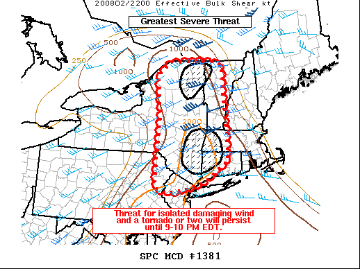
Mesoscale Discussion 1381 NWS Storm Prediction Center Norman OK 0545 PM CDT Sun Aug 02 2020 Areas affected...Western New England and Northern Mid-Atlantic Concerning...Tornado Watch 410... Valid 022245Z - 030045Z The severe weather threat for Tornado Watch 410 continues. SUMMARY...Storm coverage has remained isolated across WW 410. This trend is expected to continue this evening. Where storms can mature, such as near the NY/MA/CT border, damaging wind gusts and a tornado or two will be possible. DISCUSSION...Storm coverage within WW 410 has remained quite isolated. With the strongest forcing for ascent north of the Canadian border, this is not likely to change significantly this evening. A cluster of storms has developed within the last hour and a half near the NY/MA/CT border vicinity. One of those storms in northwestern CT has exhibited persistent mid-level rotation and a brief TDS around 6 PM EDT. These storms exist within a baroclinic zone where effective SRH is maximized. While poor low-level lapse rates may hinder stronger low-level rotation, any mature supercell that enters this favorable environment would still be capable of producing a tornado. Farther north, cumulus have continued to slowly deepen in the western Adirondacks. There is remaining favorable environment within far northeaster NY near the international border. While buoyancy is somewhat more limited that far north, low-level winds remain slightly backed. Overall, storm coverage is expected to remain isolated with potential for damaging wind gusts and a tornado or two where storms can develop and mature. The threat is expected to diminish by 9-10 PM EDT.
-
Sunday, August 2, 2020 Convective/Severe Potential
hudsonvalley21 replied to weatherwiz's topic in New England
And over here in SE NY too. Currently SBCAPE at 4000 and SBLI at -7