hudsonvalley21
-
Posts
4,265 -
Joined
-
Last visited
Content Type
Profiles
Blogs
Forums
American Weather
Media Demo
Store
Gallery
Everything posted by hudsonvalley21
-
3.8” Is the total here.
-
OBs and nowcast TUESDAY 2A-6P Feb 9, 2021
hudsonvalley21 replied to wdrag's topic in New York City Metro
3.8” Is the total here.- 82 replies
-
- 2
-

-

-
- snow
- freezing rain
- (and 1 more)
-
Additional 1-5" snow mostly North of I80 Tuesday Feb 9
hudsonvalley21 replied to wdrag's topic in New York City Metro
OKX just posted for some too. Winter Weather Advisory URGENT - WINTER WEATHER MESSAGE National Weather Service New York NY 328 PM EST Mon Feb 8 2021 CTZ005>008-NJZ002-004-103-NYZ067>070-091000- /O.NEW.KOKX.WW.Y.0004.210209T0900Z-210210T0600Z/ Northern Fairfield-Northern New Haven-Northern Middlesex- Northern New London-Western Passaic-Eastern Passaic- Western Bergen-Orange-Putnam-Rockland-Northern Westchester- 328 PM EST Mon Feb 8 2021 ...WINTER WEATHER ADVISORY IN EFFECT FROM 4 AM TUESDAY TO 1 AM EST WEDNESDAY... * WHAT...Snow expected. Total snow accumulations of 2 to 4 inches. * WHERE...Portions of northeast New Jersey, southern Connecticut and southeast New York. * WHEN...From 4 AM Tuesday to 1 AM EST Wednesday -
Porn for weather weenies

-
Obs and nowcast Super Bowl Sunday 4A-6P Feb 7, 2021
hudsonvalley21 replied to wdrag's topic in New York City Metro
Sorry, we’re not in the Toronto forum. We are in the special snowhole forum. -
Add another 1.7” to you and take it from what is owed to you from @Juliancolton
-
I’m going to split the uprights 1.45” between you and @snywx
-
Obs and nowcast Super Bowl Sunday 4A-6P Feb 7, 2021
hudsonvalley21 replied to wdrag's topic in New York City Metro
He probably used the uncleared board from the last event -
Obs and nowcast Super Bowl Sunday 4A-6P Feb 7, 2021
hudsonvalley21 replied to wdrag's topic in New York City Metro
Sounds like you have used the NWS approved measurement guidelines. -
0.75” OTG. Better than nothing I guess.
-
2-7-21 Sunday 8-12 hour nor'easter snowstorm roughly 5A-5P
hudsonvalley21 replied to wdrag's topic in New York City Metro
30/13 here -
Additional 1-5" snow mostly North of I80 Tuesday Feb 9
hudsonvalley21 replied to wdrag's topic in New York City Metro
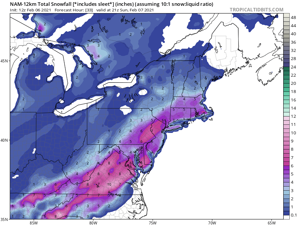
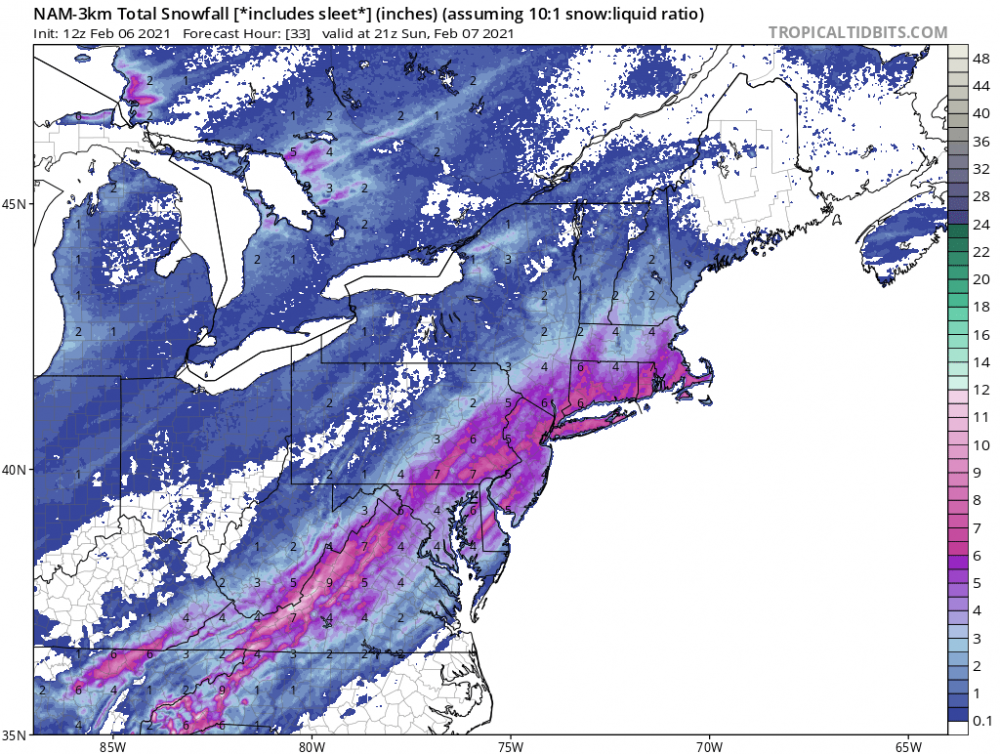
Today’s 18z GFS 24 hour snowfall map for the Tuesday event.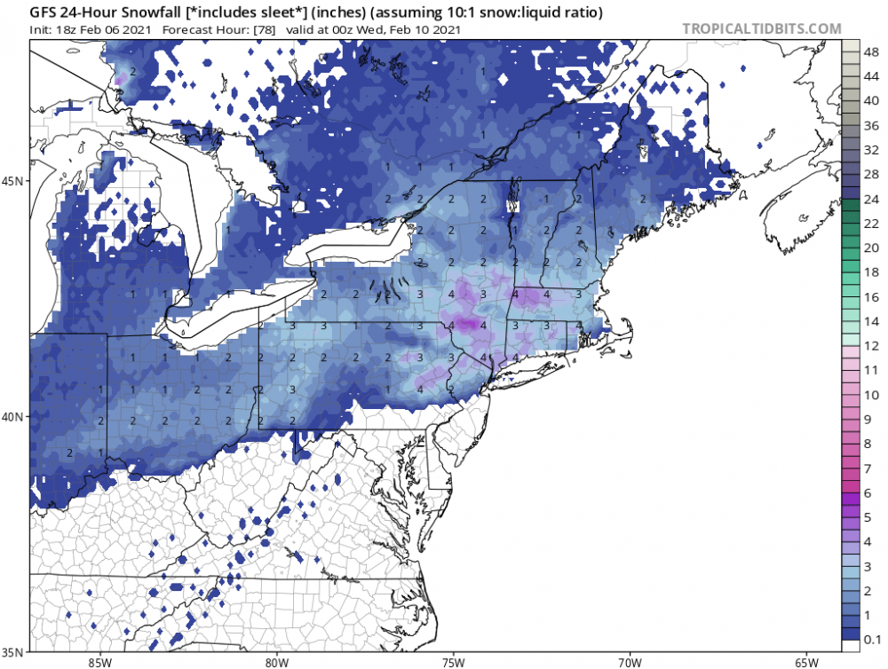
-
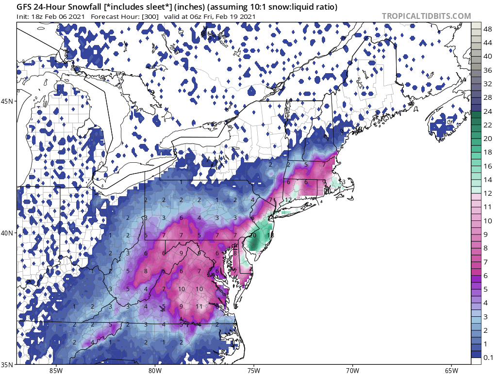
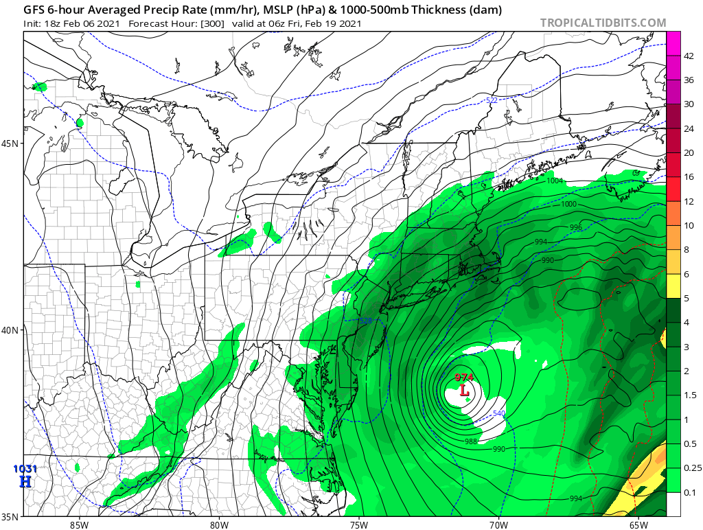
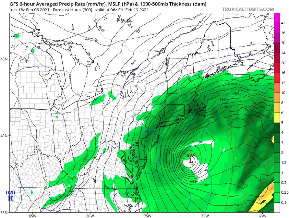
It’s showing a nice event on the 18-19th. Here is the 24 hour snowfall and surface maps for that timeframe.

-
2-7-21 Sunday 8-12 hour nor'easter snowstorm roughly 5A-5P
hudsonvalley21 replied to wdrag's topic in New York City Metro
Looks good for all the folks in the NYC metro thread. Let’s hope it holds serve. Not much more time till the event begins.
-
2-7-21 Sunday 8-12 hour nor'easter snowstorm roughly 5A-5P
hudsonvalley21 replied to wdrag's topic in New York City Metro
-
2-7-21 Sunday 8-12 hour nor'easter snowstorm roughly 5A-5P
hudsonvalley21 replied to wdrag's topic in New York City Metro
Even into Orange dutchess Sullivan counties if there are any further ticks west -
2-7-21 Sunday 8-12 hour nor'easter snowstorm roughly 5A-5P
hudsonvalley21 replied to wdrag's topic in New York City Metro
Looks good for us interior folks. -
So sad to hear, my thoughts and prayers go out to him and his family. I remember him from way back on the eastern board.
-
Hope you had some extra sheer pins
-
2-7-21 Sunday 8-12 hour nor'easter snowstorm roughly 5A-5P
hudsonvalley21 replied to wdrag's topic in New York City Metro
Basically 0.75 north and west of NYC to 1.25 in Long Island of QPF -
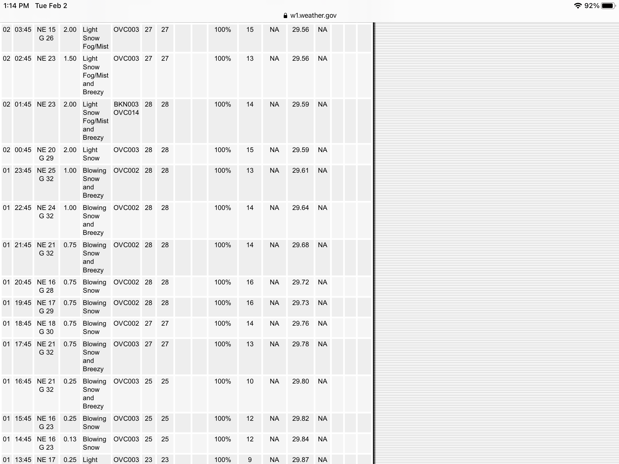
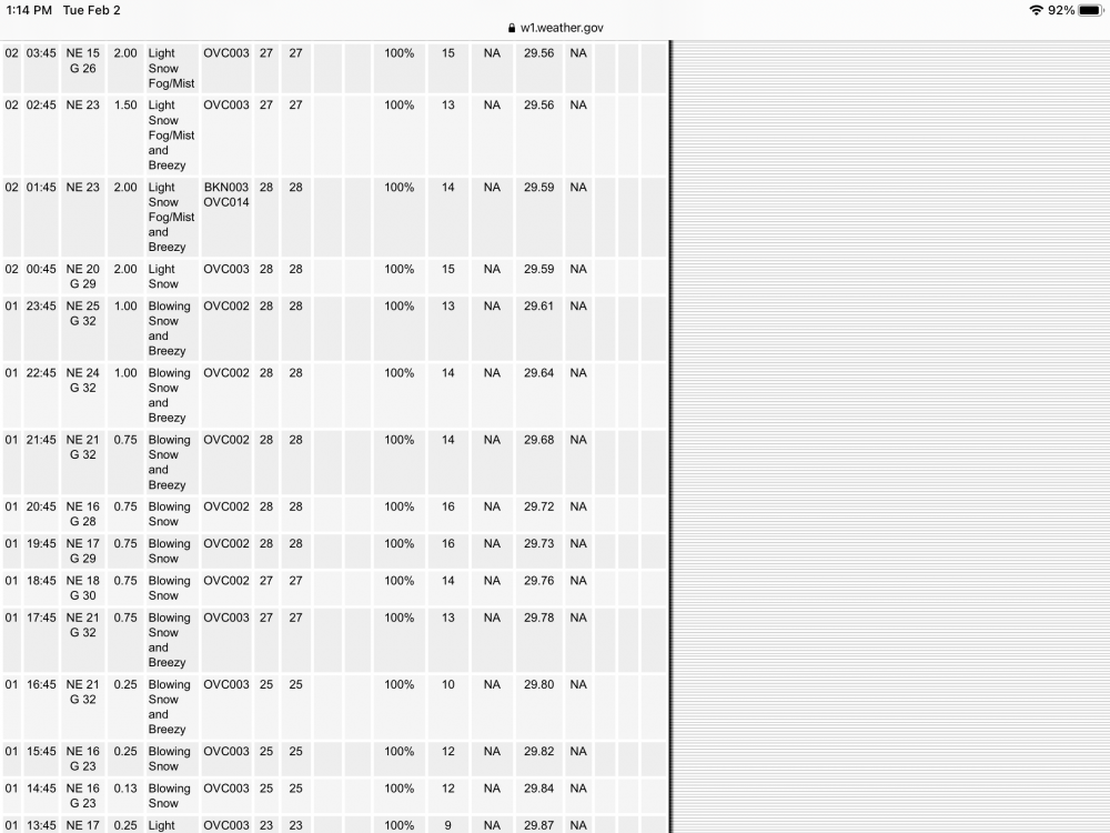
Had good winds here and for many hours. Gusts in the 30’s. Sustained winds around 15. There are some roofs with the drifting very noticeable. A screenshot from the Obs. from KSWF
-
17.3 as of 9:30 last night. Another 2.2 since then so 19.5 will do it here so far. Light snow still falling. That was with measures around 6-7 hours between.
-
It looks like 2’ is definitely possible by the latest radar.
-
Here too snow is much wetter and compacting vs earlier.