hudsonvalley21
-
Posts
4,027 -
Joined
-
Last visited
Content Type
Profiles
Blogs
Forums
American Weather
Media Demo
Store
Gallery
Everything posted by hudsonvalley21
-
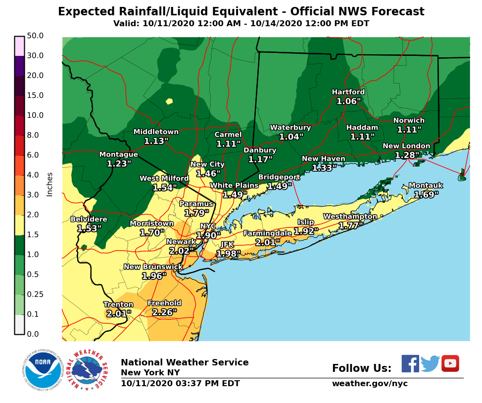
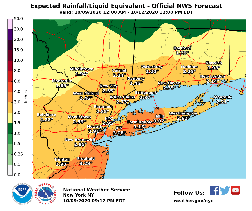
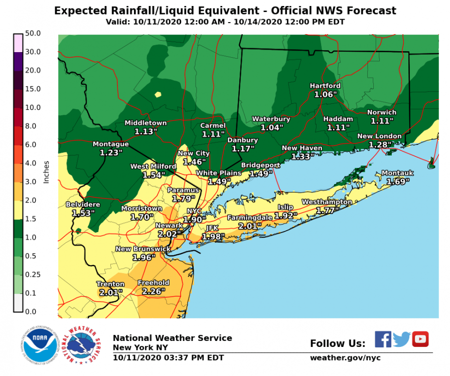
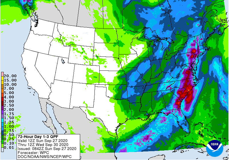
Upton’s updated QPF map has backed off somewhat.
-
October 2020 General Discussions & Observations Thread
hudsonvalley21 replied to uofmiami's topic in New York City Metro

-
October 2020 General Discussions & Observations Thread
hudsonvalley21 replied to uofmiami's topic in New York City Metro
-
Totally agree, being along the Hudson River at lower elevations is a micro climate. Up on Storm King at 1,000 ft is a totally different world along with going further inland westwards towards Montgomery/Goshen the fall leaf colors are more in swing. Then when the winter type precipitation occurs, the type and accumulations can vary in short distances. It’s very accurate when doing winter forecasts by many they use 84 as a dividing line for precipitation type and accumulations.
-
I was at weeds orchards 3 weeks ago. It was a total madhouse with non local morons walking around and a few walking around with wine bottles and their masks down. Staff was consistently on them. In addition, at the end of the day they were selling their last batch of cider donuts and some rude non mask wearing non local was giving the poor girl behind the counter a hard time because she wanted to buy all of them even with a sign limiting customers to 1 dozen. They made the poor girl cry, I went over to the local police officer that was nearby and sicked his ass on them. It’s not the same that it used to be for all the local farms. So sad.
-
October 2020 temperature forecast contest
hudsonvalley21 replied to Roger Smith's topic in Weather Forecasting and Discussion
DCA _ NYC _ BOS __ ORD _ ATL _ IAH ___ DEN _ PHX _ SEA + 0.6 +1.2 + 0.4 +0.3 +0.3 +0.5 +1.9 + 2.3 +1.7 -
1.85 here.
-
1.85 Storm total.
-
0.70 as of 10pm
-
Currently at 0.49. Maybe I should turn off the sprinkler. Too close to the rain gauge

-
Wow I’m surprised at your amount.
-
Agree. We should definitely knocking on the door of 2”+ the way the Radar is currently looking.
-
.33 here so far.
-
0.33 so far. The line coming up thru NYC area will definitely add some more before the FROPA.
-
0.27 in the Davis so far today. Hopefully, we get a little more from the band of showers moving up in central NJ before the front gets here with it’s heavier QPF to soften up the ground.
-
Hopefully we get some light rain for a few hours to soften up the ground for absorbing purposes. Everything is rock hard now. Flash flooding could definitely be an issue.
-
I’m glad I’m not under one of those flocks.
-
SVR-TOR potential 6P-11P NJ, maybe LI?
hudsonvalley21 replied to wdrag's topic in New York City Metro
Fringed up here light rain shower. -
0.27 here after midnight.
-
If it works, don’t let a good thing go. She probably forgot about it, and you save $3.98
-
0.64 here in the bucket today. Could add some more overnight after midnight.
-
DCA +1.7 NYC +1.3 BOS +1.4 ORD +0.4 ATL +1.9 IAH +0.5 DEN +1.1 PHX +2.2 SEA +2.2
-
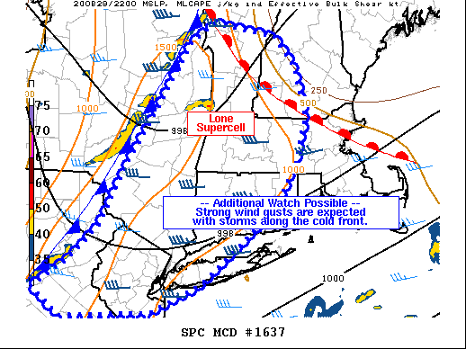
Mesoscale Discussion 1637 NWS Storm Prediction Center Norman OK 0545 PM CDT Sat Aug 29 2020 Areas affected...southeast New York...Connecticut...Massachusetts...New Hampshire Concerning...Severe Thunderstorm Watch 469... Valid 292245Z - 300045Z The severe weather threat for Severe Thunderstorm Watch 469 continues. SUMMARY...A primarily damaging wind threat may spread south and east of the severe thunderstorm watch 469. An additional watch is possible. DISCUSSION...A line of storms continues to increase in coverage and intensity along the cold front, now approaching the ALB area and extending southwestward in segmented fashion into eastern PA. Around 1500 J/kg MLCAPE exists ahead of the front, along with increasing GPS PWAT values up to 2.00" from the Chesapeake to CT. The moist air mass, combined with lift along the front should maintain a threat of storms along the front, with a few severe gusts possible. ..Jewell.. 08/29/2020
-
Yup real close. Dodged a bullet. Others weren’t so lucky. The view would have been awesome from up by the parking lot especially being on the southern side of the cell.
-
PUBLIC INFORMATION STATEMENT NATIONAL WEATHER SERVICE NEW YORK NY 934 PM EDT FRI AUG 28 2020 ...NWS DAMAGE SURVEY FOR 08/27/2020 TORNADO EVENT... ...EF1 TORNADO CONFIRMED IN MONTGOMERY, NY... START LOCATION...ORANGE COUNTY AIRPORT, ORANGE COUNTY, NY END LOCATION...OLD NEALYTOWN ROAD, ORANGE COUNTY, NY DATE...AUGUST 27, 2020 ESTIMATED TIME...6:15 PM TO 6:20 PM MAXIMUM EF-SCALE RATING...EF1 ESTIMATED MAXIMUM WIND SPEED...90 MPH MAXIMUM PATH WIDTH...600 YARDS PATH LENGTH...2.6 MILES BEGINNING LAT/LON...41.525581/-74.26033 INTERMEDIATE LAT/LON...41.518964/-74.248640 ENDING LAT/LON...41.511234/-74.215244 * FATALITIES...0 * INJURIES...0 ...SUMMARY... A NATIONAL WEATHER SERVICE STORM SURVEY TEAM CONFIRMED AN EF1 TORNADO IN MONTGOMERY, ORANGE COUNTY, NY. THE TORNADO LIKELY TOUCHED DOWN ON THE NORTHWEST SIDE OF THE ORANGE COUNTY AIRPORT NEAR THE WALLKILL RIVER. STRAIGHT LINE WINDS ON THE SOUTHERN FLANK OF THE TORNADO LIKELY CAUSED TREE DAMAGE AT THE INTERSECTION OF ROUTE 211 AND CANNING ROAD AS WELL AS MINOR STRUCTURAL DAMAGE NOTED TO TWO BUILDINGS ON THE AIRPORT. A TEMPORARY METEOROLOGICAL STATION, INSTALLED ON THE AIRFIELD TO SUPPORT THIS WEEKEND'S AIRSHOW, MEASURED SUSTAINED WINDS OF 69 MPH WITH A PEAK GUST OF 82 MPH BEFORE THE COMMUNICATIONS WENT OUT. THE TORNADO MOVED EAST FROM NEAR THE RIVER INTO THE VILLAGE OF MONTGOMERY, WHERE DAMAGE WAS EXTENSIVE ALONG WEAVER STREET, AS WELL AS CHANDLER LANE. THE TORNADO THEN CONTINUED EASTWARD ACROSS BEAVER DAM ROAD TO OLD NEALYTOWN ROAD WHERE IT ENDED. THE BULK OF THE DAMAGE CONSISTED OF LARGE SNAPPED AND UPROOTED TREES. THE NWS WOULD LIKE TO THANK EMERGENCY MANAGEMENT, LAW ENFORCEMENT, BROADCAST MEDIA, SPOTTERS WHO SHARED VIDEO AND PHOTOGRAPHIC EVIDENCE, AND REPORTS FROM THE GENERAL PUBLIC THROUGH SOCIAL MEDIA, IN ASSISTING IN THE SURVEY AND FORMULATING THIS PRELIMINARY DAMAGE ASSESSMENT.