hudsonvalley21
-
Posts
4,027 -
Joined
-
Last visited
Content Type
Profiles
Blogs
Forums
American Weather
Media Demo
Store
Gallery
Everything posted by hudsonvalley21
-
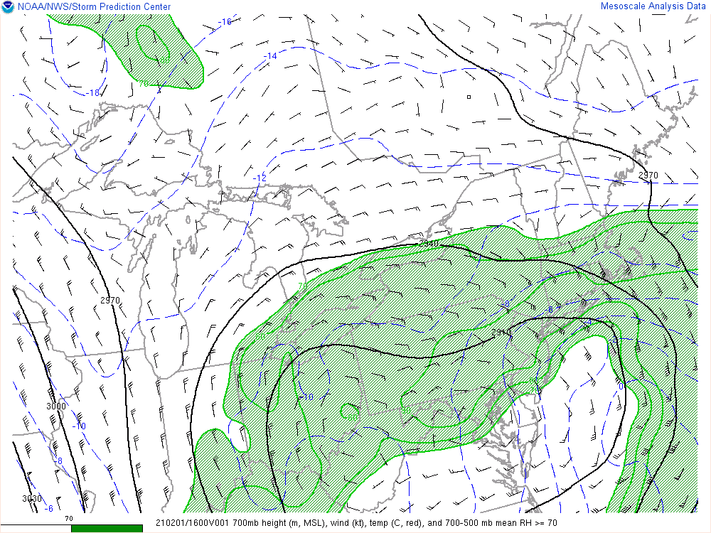
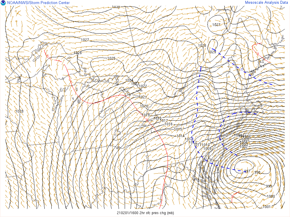
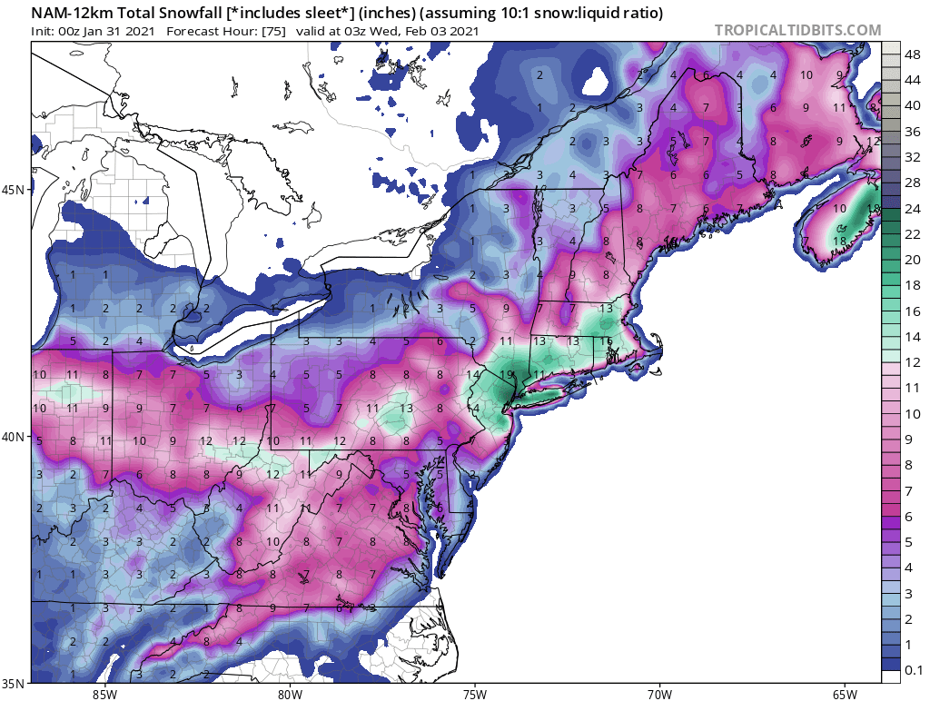
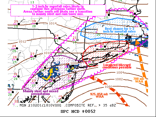
Mesoscale Discussion 0052 NWS Storm Prediction Center Norman OK 1243 PM CST Mon Feb 01 2021 Areas affected...portions of far eastern Pennsylvania...central and northern New Jersey...far southeast New York...Long Island...Connecticut...Rhode Island...Massachusetts Concerning...Heavy snow Valid 011843Z - 020045Z SUMMARY...Up to 2-4 inch/hr snowfall rates will be possible across portions of the lower Hudson Valley and southern New England this afternoon, with occasional blizzard conditions possible across Long Island. Portions of far eastern Pennsylvania into central New Jersey will continue to experience a heavy sleet/snow mix. DISCUSSION...A surface low continues to gradually deepen while tracking slowly north-northeastward just off the Jersey shoreline as a 110+ knot 300 mb jet traverses the Mid Atlantic/New England Coastline. Strong 925-700 mb warm-air advection ahead/north of the surface low continues to support ample mixed wintry precipitation/heavy snowfall potential amidst a sub-freezing tropospheric vertical profile and deep-layer ascent provided by coupled low-level convergence with the surface low and upper-level divergence by the strong 300 mb jet (per latest Mesoanalysis). Latest KDIX/KOKX dual-polarimetric radar depicts a an east to west snow/sleet transition zone roughly from KLOM to KISP. Latest METAR observations also show 1-3 inch/hr snowfall rates ongoing just north of this transition zone, and the heavier snow/sleet are expected to gradually translate northward through the afternoon. METAR sites also show 25 knot sustained northeasterly winds prevailing across Long Island, along with heavy snow and higher gusts noted. As such, brief and localized blizzard conditions are expected to persist. Latest HREF, SREF, and last few runs of the HRRR suggest that relatively lighter snowfall rates mixed with sleet will be the predominant mode of precipitation from far eastern PA/central NJ southward this afternoon, with a transition of sleet likely across portions of Long Island and brief/localized blizzard conditions still possible. Farther north across parts of southern New England, the heavier band of wintry precipitation will progress northward, with strong 700 mb warm-air advection and a near-saturated dendritic growth zone supporting 1-3 inch/hr snowfall rates this afternoon, as suggested by high-resolution model guidance. A few brief instances of 4 inch/hr rates also cannot be ruled out.
-
-
5.5” otg. 21/21
-
5.5 otg 21/21
-
You get under a deform band that might overcome that n/e flow. Hope it works out for you.
-
That’s strange. Had very light snow falling here for over an hour now. 19/10
- 1,932 replies
-
- 2
-

-
- heavy snow
- wind damage
- (and 1 more)
-
First flakes now falling. 19/10
-
First flakes now falling. 19/10
-
I’m thinking about clearing about 12 every hours. I will also try to measure some wind sheltered areas after the event ends too see the difference. If we end up with around 20” or so it will be interesting too see the compaction.
-
Hopefully you got it back up and running
-
DCA: +0.3 NYC +1.1 BOS: +0.1 ORD: - 0.3 ATL: - 0.2 IAH: - 0.2 DEN: +1.3 PHX: +1.7 SEA: +0.9
-
In their AFD, They were leaning towards the NAM.
-
I’m sure you have an emergency backup.

-
Agree to the criteria that’s defined below. They could be thinking that the sustainable winds won’t occur for another 24 hours. Blizzard Warning A Blizzard Warning means that the following conditions are occurring or expected within the next 12 to 18 hours. 1) Snow and/or blowing snow reducing visibility to 1/4 mile or less for 3 hours or longer AND 2) Sustained winds of 35 mph or greater or frequent gusts to 35 mph or greater. There is no temperature requirement that must be met to achieve blizzard conditions.
- 2,426 replies
-
- 1
-
-
- heavy snow
- ice pellets
- (and 3 more)
-
Cloud deck lowering, 19/9
-
Interesting, for the few days it was showing rain for next weekend. Oh well, let’s keep it going
-
We could have areas with variations of several inches in short travel distances. All depends on those ccb mega bands where they set up too. Would be cool to have some thundersnow too.
-
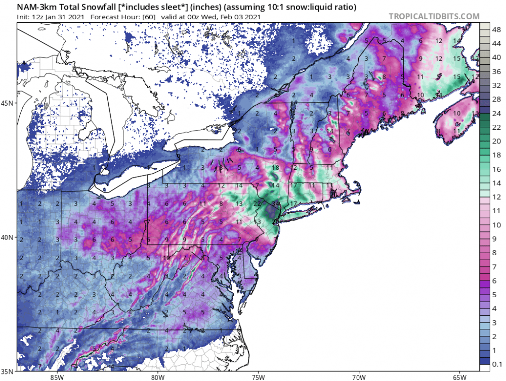
3k NAM is pure porn, well juiced most of the models are a jackpot for our neck of the woods. Hopefully the winds aren’t too high, would cause some incredible drifting.
-
How much for philly Crazy numbers for us folks up this way.
- 2,426 replies
-
- 1
-
-
- heavy snow
- ice pellets
- (and 3 more)
-
Another thing that could be a factor is what Wdrag mentioned the other day in reference to the above normal SST’s off the NJ/DE coasts.
-
Thru 60 hrs with 24 more to go.
-
I second that