hudsonvalley21
-
Posts
4,028 -
Joined
-
Last visited
Content Type
Profiles
Blogs
Forums
American Weather
Media Demo
Store
Gallery
Everything posted by hudsonvalley21
-
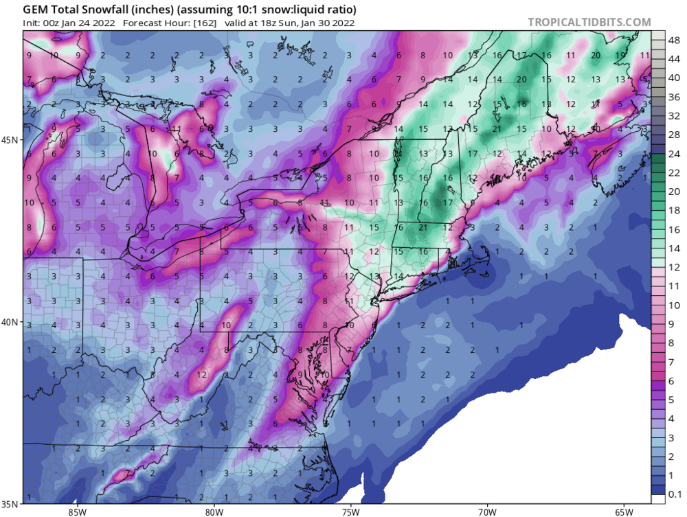
Almost there. Maybe 00z -12z on Thursday should do it. 50-100 mile shift could make a difference. Also there is a possibility of it slowing or stalling out. Just a few more runs.
-
-
Absolutely, I would start getting comfortable after the 12z runs Thursday. For now it’s sit back and see what evolves till then.
-

-
Light snow here, coating on all surfaces. 27/23
-
Model mayhem this season. Flip flopping more than a fish out of water.

-
-
I won, low of -1 here.
-

-
Me too on the over.
-
Points click forecast low for me is -3 tonight. We’ll see what happens. Area Forecast Discussion National Weather Service New York NY 243 PM EST Fri Jan 21 2021 NEAR TERM /THROUGH TONIGHT/... Cirrus had thinned out for a while, but should make a comeback this evening ahead of an upper trough approaching from the west, with partly cloudy to mostly cloudy skies. The associated sfc low and its deeper low level moisture will remain south. Trended colder tonight with temps per latest MOS guidance, with lows 10-15 in/around NYC, single digits most elsewhere, and 0 to 5 below across Orange/Putnam/N Westchester where winds should decouple over snow pack late tonight. Steady N flow in combination with these temps will result in minimum wind chills around zero in NYC, 0 to 5 below in most suburbs and across Long Island and the immediate SW CT coast, and 5 to 10 below farther north/west.
-
1.2” total here.
-
1.2” is the total here.
-
Special Weather Statement National Weather Service New York NY 835 AM EST Thu Jan 20 2022 CTZ005>008-NJZ002-103-NYZ067>070-201600- Northern Fairfield-Northern New Haven-Northern Middlesex- Northern New London-Western Passaic-Western Bergen-Orange-Putnam- Rockland-Northern Westchester- 835 AM EST Thu Jan 20 2022 ...SNOW THIS MORNING... Light to moderate snow will continue this morning. The snow will taper off by around noon. Totals in the 1 to 2 inch range can be expected by the time the snow ends. Extra caution should be used if traveling this morning.
-
Getting ugly up here. Roads snow covered, salt trucks out doing their thing.
- 280 replies
-
- 1
-

-
- snow
- freezing rain
- (and 1 more)
-
Down to 32 here with moderate snow. Roads snow covered, quick 0.3” so far. Radar back filled in nicely.
- 280 replies
-
- 1
-
-
- snow
- freezing rain
- (and 1 more)
-
Down to 32 here with moderate snow. Roads snow covered, quick 0.3” so far. Radar back filled in nicely.
-
There is talk about spacing between events. Is this between Thursday and Saturday, or is there another event after Saturday?
-
Agree, I think it will catch some folks off guard later.
-
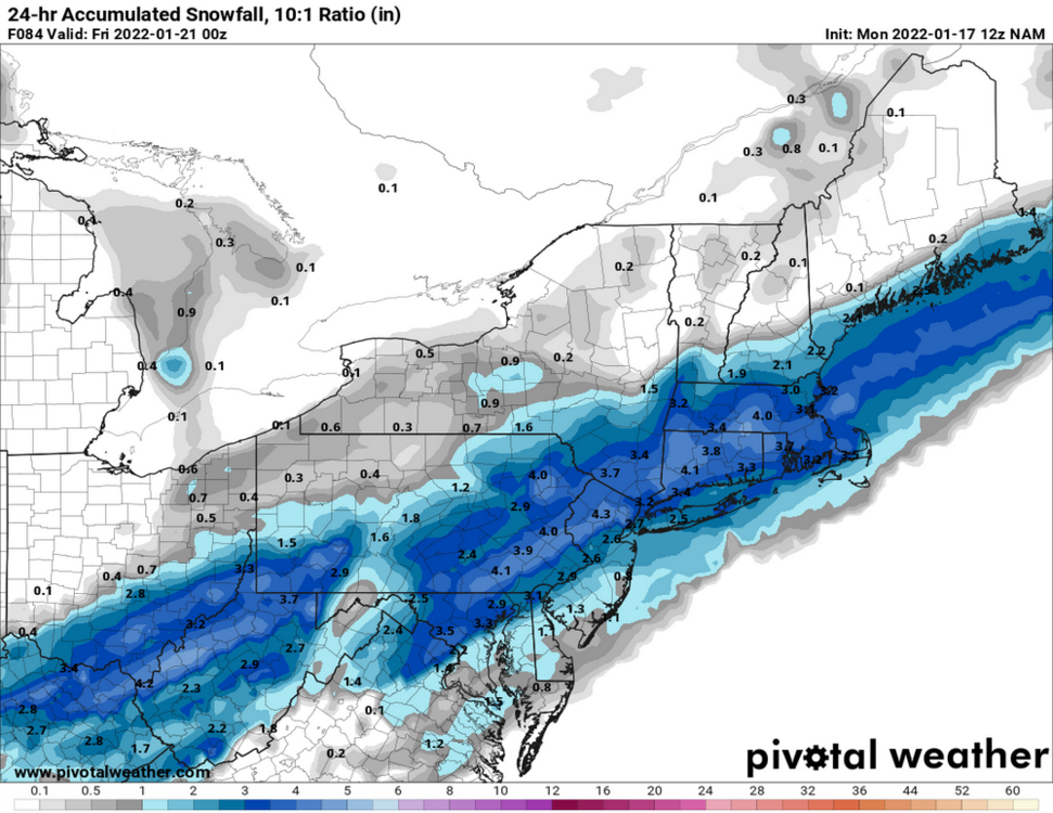
The frozen ground is leaving some water puddles in low lying areas that will definitely freeze tonight and tomorrow night. Now the 12z NAM is spitting out around 4” Thursday.
-
5.1” for the total here.
-
Same here with moderate/ heavy. 2.5” otg. 25/24
-
25/24 moderate snow, no mixing yet. 2.5” otg.
-
23/21 moderate snow. 1.0” otg.