hudsonvalley21
-
Posts
4,027 -
Joined
-
Last visited
Content Type
Profiles
Blogs
Forums
American Weather
Media Demo
Store
Gallery
Everything posted by hudsonvalley21
-
Same here, looking at the current radar, the squall out by KBGM has another developing area of precipitation just in front of it
-
February 24/25 Potential Winter Storm
hudsonvalley21 replied to mikem81's topic in New York City Metro
Snow porn, sorry for the useless post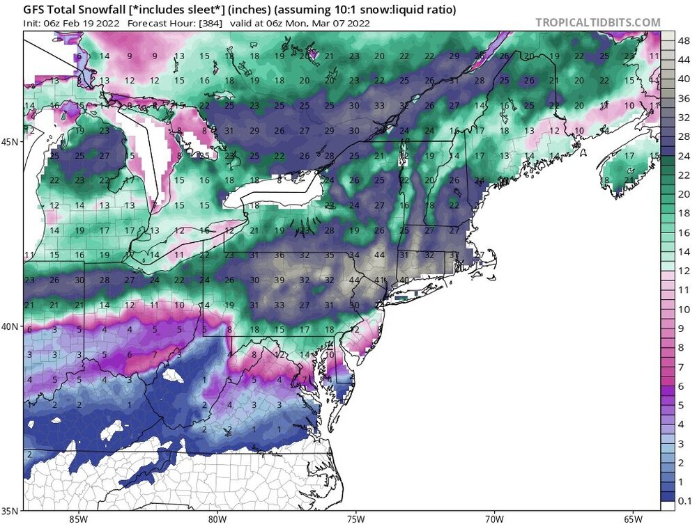
-
I see your clown and raise you another one.
-
Cloudy and 59 currently.
-
Totally agree, hoping for a way overdone map.
-
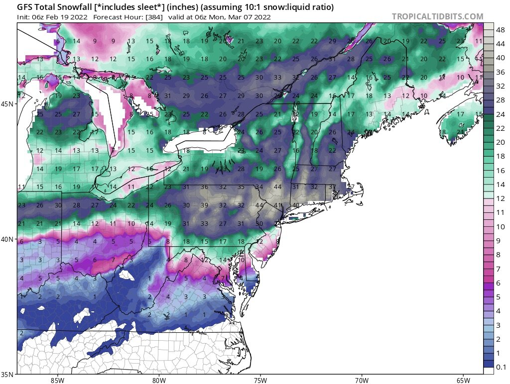
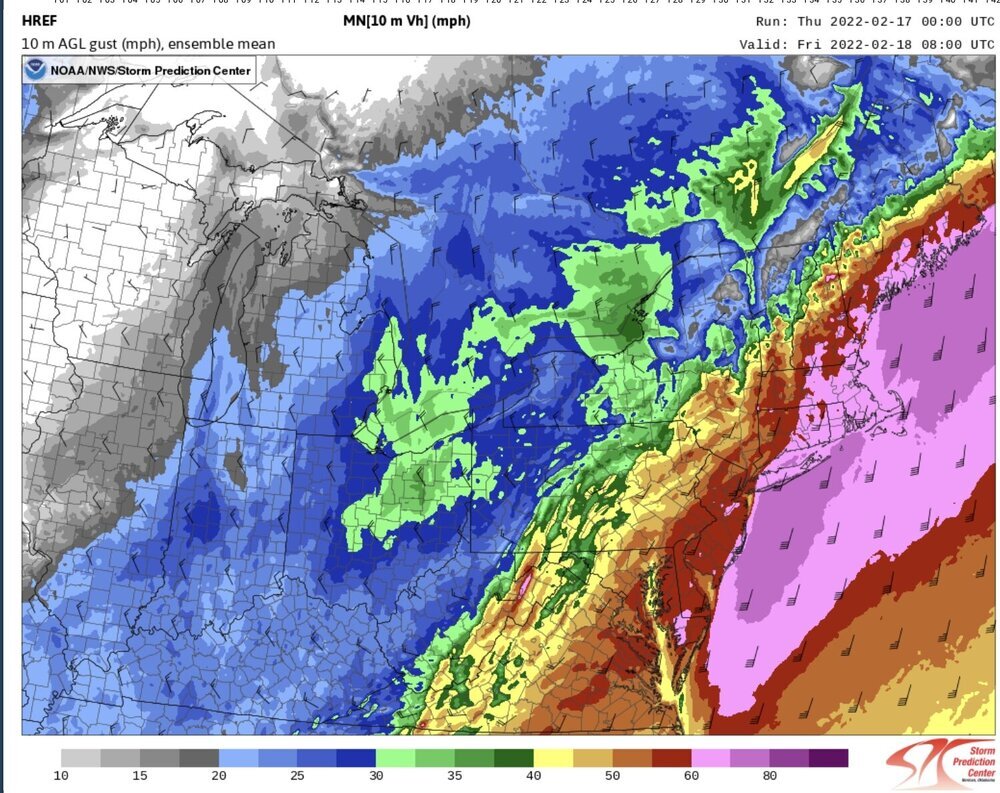
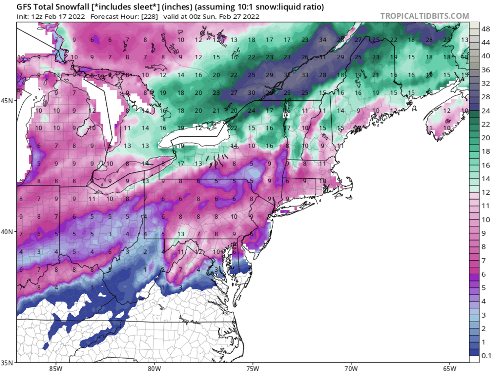
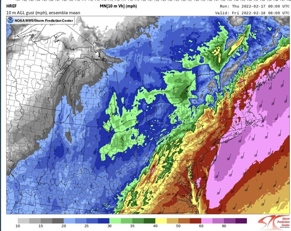
For the overnight hours coming up. upton’s AFD SHORT TERM /6 PM THIS EVENING THROUGH FRIDAY NIGHT/... Sheared shortwave energy races into the eastern Great Lakes tonight, ahead of northern stream shortwave pivoting through the Upper Great Lakes. In response, gradually deepening low pressure/s track from the Ohio River valley this evening up through Western NY tonight, with trailing strong cold front approaching the region, bringing a period of strong to damaging wind gusts and moderate to heavy rain tonight into Friday morning. Ahead of the cold front, models are in good agreement with a strong llj (70-80kt@950mb) developing across eastern coastal areas late tonight into early Friday morning. As is typical for this time of year with water temps in the lower 40s, the challenge is how much of the llj will be able to mix down in a strongly inverted low-level environment. GFS/NAM have remained fairly consistent over the last 48 hrs, with GFS indicating a typically slightly deeper mixed layer, with potential for 50 kt gusts across LI/SE CT, while NAM more strongly inverted indicating gust potential of 40 kt. NBM has trended slightly upward with gust magnitude from 24 hrs ago, with 4.0 indicating 45-50kt gust potential for LI and SE CT, while version 4.1 continuing to showing a 45-55 kt potential for LI/CT. HRRR 10m wind gust potential, which has show to be skillful (albeit a little high) indicating potential for 55-60kt gusts for LI and SE CT as well. SPC HREF indicating high potential for 30kt sustained winds across LI/SE CT as well (not common), supporting the strong to damaging wind gust potential. Based on the model consistency and trends over the last few days, confidence is high in a strong wind (wind advisory) event tonight across the entire area, including NYC (45-55mph gusts), with moderate to high confidence in high winds gusts (55-65mph) for LI and SE CT under the core of the 75-80 kt llj. The timing for peak strong to high wind gusts continues to center around 6-12z Fri. Despite the strong inversion, based on the slight upward trend on NBM 4.0 wind gust guidance towards the stronger NBM 4.1 guidance, the strong signal from CAM guidance, and the anomalous strength of the llj, will upgrade to a high wind warning for all of LI and SE CT. Elsewhere will issue a wind advisory for strong wind gust potential ahead of and immediately behind the cold front, with highest threat along the coast and higher elevations. In terms of heavy rain potential, deep layered lift of a +3-4 STD PWAT gulf moisture plume, and weak elevated instability, will present potential for a 3-6 hr window of moderate to heavy rain tonight. The limiting factor for heavy rainfall amounts will be quick movement of the cold front through the area, racing ahead of shortwave forcing. Medium range ensemble spread generally from 1/2 to 1 inches of rainfall for city/coast, with 1 to 1 1/4 across interior (particularly S CT). SPC HREF indicating a similar distribution, with signal for enhancement along the north shore of LI, interior S CT, and hill terrain. These areas of enhancement are consistent with SBU research on standing gravity wave perturbation precip enhancement in southerly flow events. Steadier rainfall develops from west to east this evening through midnight, with narrow bands of heavy rain indicated by CAMs late tonight with llj and along/ahead of cold front. Rain will quickly come to and end early Friday morning from west to east with cold frontal passage. A few wet snowflakes possible across far NW hills before ending, with no accum. The cold front pushes through Fri AM, with winds shifting to W/NW. Potential for wind advisory gusts of 40-50mph Friday morning areawide with wind shift as lapse rates rapidly steepen/deepen. Gusts should settle into the 30 to 35 mph range for the afternoon. It will be drying out with sunshine for the afternoon, and temps dropping through the day (50s AM to 30s PM) with modified polar airmass advecting in. High pressure noses in Friday Night, with potential for a window of radiational cooling well down into into the teens across pine barrens and interior, 20s elsewhere. High clouds and return flow begin to increase towards Sat morning, with rising temps likely along the coast, ahead of Ontario clipper s
-
Never heard of them. I know. Moe, Larry and curly.
-
I’ll embarrass him and show one of his finest photos
-
3.80” here. Light snow currently.
-
It wouldn’t be whiff now would it.

-
2/13 Light/Moderate Snowfall Nowcasting & Observations
hudsonvalley21 replied to Northof78's topic in New York City Metro
If this is the result we’ll get. I’d rather have mostly sunny skies and move on. -
Mud just on the surface. Frozen underneath. Snow cover it, or shut down winter and let’s move on.
-
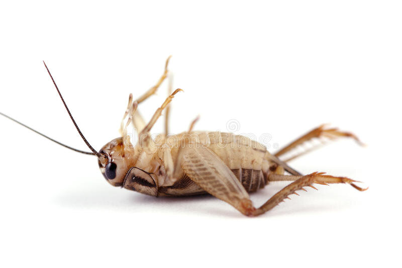
Very quiet crickets
-
Hopefully you’re ok. Black ice here on untreated surfaces. 32 degrees currently.
-
Quite the event, very impressive. We lucked out vs. the folks up in Ulster county.
-
That’s how he would buy his car

-
I see the forecast low for you up there is -12.
-
Everything can go wrong, so let’s La La lock it up and get called weenies. oops my bad, I forgot this is the interior thread.
-
And 23 here currently up the Hudson River valley. Temps have been 32 or lower since 2am at KSWF.
-
Congrats
-
The snow and sleet will give you some traction.
-
I just threw down calcium chloride a few times today. I’ll leave the ice pellets alone for traction. I’ll chop it tomorrow.
-
Forecast low of 15 tonight. Went out to de-ice the car. Doors were frozen from last nights rain. Folks should go out now and de-ice plus throw down some salt.
-
25 with freezing drizzle currently.