hudsonvalley21
-
Posts
4,028 -
Joined
-
Last visited
Content Type
Profiles
Blogs
Forums
American Weather
Media Demo
Store
Gallery
Everything posted by hudsonvalley21
-
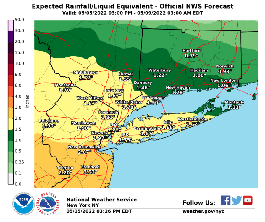
Flood Advisory National Weather Service New York NY 627 PM EDT Sun May 15 2022 NYC071-160130- /O.NEW.KOKX.FA.Y.0011.220515T2227Z-220516T0130Z/ /00000.N.ER.000000T0000Z.000000T0000Z.000000T0000Z.OO/ Orange NY- 627 PM EDT Sun May 15 2022 ...FLOOD ADVISORY IN EFFECT UNTIL 930 PM EDT THIS EVENING... * WHAT...Urban and small stream flooding caused by excessive rainfall is expected. * WHERE...A portion of southeast New York, including the following county, Orange. * WHEN...Until 930 PM EDT. * IMPACTS...Minor flooding in low-lying and poor drainage areas. * ADDITIONAL DETAILS... - At 626 PM EDT, Doppler radar indicated heavy rain due to thunderstorms. This will cause urban and small stream flooding. Between 0.5 and 1 inch of rain has fallen. - Additional rainfall amounts up to 1 inch are expected over the area. This additional rain will result in minor flooding. - Some locations that will experience flooding include... Middletown, Port Jervis, Goshen, Howells, Chester, Montgomery, Cuddebackville, Otisville, Huguenot, Scotchtown, Deerpark, Mechanicstown, Westtown, Maybrook, Slate Hill, Pine Bush, Circleville, Bullville and New Hampton. - http://www.weather.gov/safety/flood
-
0.00 here.
-
74/59 here currently. Forecast high of 78 today. High yesterday was 77. Did some outdoor painting yesterday and today , great weather for that.
-
-

-
I’d like to move to the Bronx, that way I’ll definitely be in the NYC metro thread area.
-
Sun just starting to come thru here. 0.14” here so far, temp currently 57.
-
May 2022 temperature forecast contest
hudsonvalley21 replied to Roger Smith's topic in Weather Forecasting and Discussion
DCA +1.1 NYC +1.1 BOS +1.1 ORD -1.1 ATL +1.7 IAH +1.4 DEN +0.2 PHX +0.6 SEA -0.2 -
All rain here at an elevation of 125’. Temp. 38 rainy week coming up
-
As you know, wore many hats in rockland. Chief in Valley cottage, held many positions in the county along with being the voice ( dispatcher) at 44 control. Well respected.
-
Barry Furey I remember when going thru fire training in Rockland county back in the 70’s. Great guy.
-
April 2022 temperature forecast contest
hudsonvalley21 replied to Roger Smith's topic in Weather Forecasting and Discussion
DCA +2.7 NYC +2.1 BOS +1.9 ORD +1.6 ATL +2.5 IAH +3.0 DEN +2.2 PHX +0.7 SEA -0.1 -
Special Weather Statement National Weather Service New York NY 712 PM EDT Sat Mar 19 2022 NYZ067-200015- Orange NY- 712 PM EDT Sat Mar 19 2022 ...A strong thunderstorm will impact portions of Orange County through 815 PM EDT... At 711 PM EDT, Doppler radar was tracking a strong thunderstorm over Unionville, or 9 miles east of Port Jervis, moving northeast at 45 mph. HAZARD...Winds in excess of 40 mph and half inch hail. SOURCE...Radar indicated. IMPACT...Gusty winds could knock down tree limbs and blow around unsecured objects. Minor damage to outdoor objects is possible. Locations impacted include... Middletown, Port Jervis, Walden, Warwick, Goshen, Howells, Gardnertown, Chester, Montgomery, Florida, Cuddebackville, Otisville, Huguenot, Unionville and Scotchtown.
-
3.6” here.
-
Could be the northwest winds drying it out. Here the wind is picking up from the northwest and blowing the accumulated snow around. No snowfall yet from the approaching line but I assume it will be soon.
-
It will be interesting to see what the approaching line will give us soon.
-
I’m estimating around 3” here.
-
Radar showing precipitation breaking down in southeast Pa. this could be winding down in a couple of hours.
-
Going to be an interesting day to say the least. Tough day for you to measure the snowboards with the forecasted winds.
-
All snow now. 32/32
-
All snow here now. 32 degrees
-
Ice pellets with snow mixing in 35 degrees