

hudsonvalley21
-
Posts
4,027 -
Joined
-
Last visited
Content Type
Profiles
Blogs
Forums
American Weather
Media Demo
Store
Gallery
Everything posted by hudsonvalley21
-
Not sure your thinking in SE NY where you think the action will be. You have some viewing area the Mohonk and Storm king mountain areas.
-
Enjoy the weekend. Hopefully you will see a waterspout to ease the pain for the expensive hotel room you will be holed up in.
-
I second that.
-
They are adult lanterflies
-
Same here for yesterday. 0.01” in the bucket.
-
Is it tears or sweat
-
Hopefully she’s back to 100%. Congratulations on the graduation
-
Currently 70 here. Fog lifted out about 30 minutes ago. Forecast high is 95, we’ll see.
-
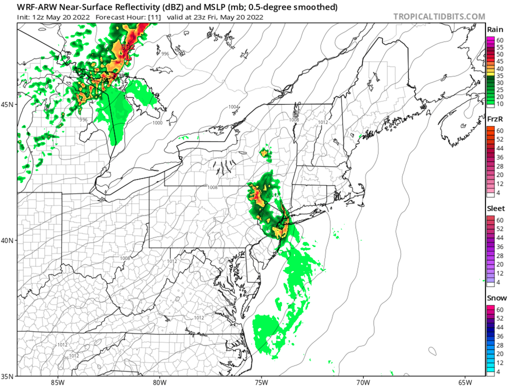
WRF is split
-
0.55” in the bucket from this afternoons events.
-
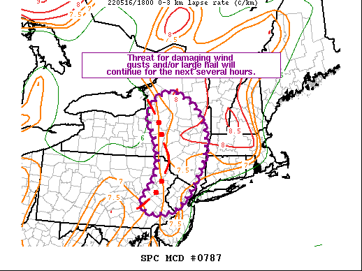
Mesoscale Discussion 0787 NWS Storm Prediction Center Norman OK 0143 PM CDT Mon May 16 2022 Areas affected...Eastern NY...Far Eastern PA...Northern NJ Concerning...Severe Thunderstorm Watch 226...227...229... Valid 161843Z - 162015Z The severe weather threat for Severe Thunderstorm Watch 226, 227, 229 continues. SUMMARY...The threat for damaging wind gusts and large hail will persist for at least the next several hours across eastern NY, far eastern PA, and northern NJ. DISCUSSION...Regional radar imagery shows an expansive convective line extending from just east of Lake Ontario southward into northeast PA and then back southwestward across far eastern PA. Air mass downstream of this line has warmed into the upper 70s and low 80s. Mesoanalysis estimates 0-3 km lapse rates over 7.5 deg C per km across much of this region. Linear convective structure coupled with moderate buoyancy and steep low-level lapse rates suggests the threat for damaging wind gusts will persist with this line as it moves eastward this afternoon. Cellular development ahead of the line will likely continue this afternoon as well. These storms could produce large hail and/or damaging wind gusts, particularly as a result of updraft augmentation due to interaction with the approaching line.
-
-
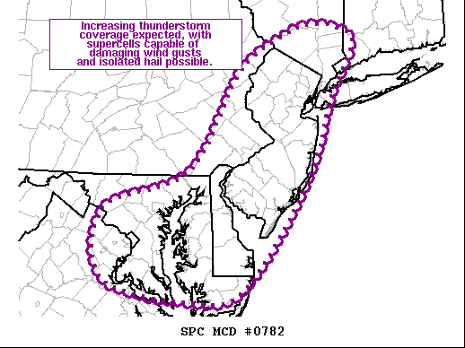
We’ll back to the weather, new meso out Mesoscale Discussion 0782 NWS Storm Prediction Center Norman OK 1101 AM CDT Mon May 16 2022 Areas affected...Far Northeast VA...Eastern MD...DE...NJ...NY Hudson Valley Concerning...Severe potential...Watch likely Valid 161601Z - 161800Z Probability of Watch Issuance...80 percent SUMMARY...Increased thunderstorm coverage is expected over the next few hours, with supercells capable of damaging wind gusts and hail possible. DISCUSSION...Recent radar and satellite imagery has shown an increase in the showers from northern VA into NJ, with a few stronger embedded updrafts. This area is indicative of the increased ascent preceding the shortwave trough and attendant cold front. Air mass over most of the region has warmed into the low 70s amid dewpoints in the mid 60s. While cloud cover may impede heating somewhat, this air mass is still expected to further destabilize over the next few hours. As it does, a few stronger updrafts may manifest within this warm-air advection regime. Moderate shear is in place, so any stronger, more persistent updrafts could organize, and the potential for a few supercells capable of isolated hail and damaging wind gusts exists. Greatest chance for severe thunderstorms during the next few hours appears to be across NJ and into the Hudson Valley where temperatures are highest. Convective trends are being monitored across the entire region for likely watch issuance. ..Mosier/Grams.. 05/16/2022
-
We have the same type damage from last year in the town of Newburgh area and across the Hudson to the Fishkill area in Dutchess county. Agree with seeing more tornado activity in the area.
-
It’s also unhealthy to die this way. You’re entitled to your opinion.
-
Talk to some folks in Orange County,ny, they might think differently. On November 16, 1989, a wind gust at 12:05 PM blew down the free standing cafeteria wall at the East Coldenham Elementary School near Newburg, NY. Nine students were killed. The event was called a tornado, but the only rotation seen in the area was a dust swirl in the parking lot. Professor Fujita's detailed survey of the entire path showed only evidence of microbursts. It exists on official records as a tornado, the deadliest F1 "tornado" in history.
-
76/68 here currently. High clouds starting to move in from the s/w.
-
Some schools on this side of the Hudson are doing the same
-
Monday, May 16, 2022 Convective Potential
hudsonvalley21 replied to weatherwiz's topic in New England
In my region to your west, the north/south running valleys should keep an eye out for the discrete cells that form in front the linear action. -
Picked up a quick 0.13 light rain currently.
-
I’m at 0.11 for the day and that occurred overnight.
-
Shelf cloud come rolling over. No precipitation or thunder with it so far.
-
Special Weather Statement National Weather Service New York NY 652 PM EDT Sun May 15 2022 NYZ067-152330- Orange NY- 652 PM EDT Sun May 15 2022 ...Strong thunderstorms will impact portions of northwestern Orange County through 730 PM EDT... At 651 PM EDT, Doppler radar was tracking strong thunderstorms along a line extending from Highview to near Huguenot. Movement was east at 25 mph. HAZARD...Winds in excess of 40 mph and pea size hail. SOURCE...Radar indicated. IMPACT...Gusty winds could knock down tree limbs and blow around unsecured objects. Minor damage to outdoor objects is possible. Locations impacted include... Middletown, Port Jervis, Walden, Howells, Montgomery, Cuddebackville, Otisville, Huguenot, Unionville, Scotchtown, Deerpark, Mechanicstown, Westtown, Maybrook and Slate Hill.
-
81 was the high here.
-
Flood Advisory National Weather Service New York NY 627 PM EDT Sun May 15 2022 NYC071-160130- /O.NEW.KOKX.FA.Y.0011.220515T2227Z-220516T0130Z/ /00000.N.ER.000000T0000Z.000000T0000Z.000000T0000Z.OO/ Orange NY- 627 PM EDT Sun May 15 2022 ...FLOOD ADVISORY IN EFFECT UNTIL 930 PM EDT THIS EVENING... * WHAT...Urban and small stream flooding caused by excessive rainfall is expected. * WHERE...A portion of southeast New York, including the following county, Orange. * WHEN...Until 930 PM EDT. * IMPACTS...Minor flooding in low-lying and poor drainage areas. * ADDITIONAL DETAILS... - At 626 PM EDT, Doppler radar indicated heavy rain due to thunderstorms. This will cause urban and small stream flooding. Between 0.5 and 1 inch of rain has fallen. - Additional rainfall amounts up to 1 inch are expected over the area. This additional rain will result in minor flooding. - Some locations that will experience flooding include... Middletown, Port Jervis, Goshen, Howells, Chester, Montgomery, Cuddebackville, Otisville, Huguenot, Scotchtown, Deerpark, Mechanicstown, Westtown, Maybrook, Slate Hill, Pine Bush, Circleville, Bullville and New Hampton. - http://www.weather.gov/safety/flood


