hudsonvalley21
-
Posts
4,027 -
Joined
-
Last visited
Content Type
Profiles
Blogs
Forums
American Weather
Media Demo
Store
Gallery
Everything posted by hudsonvalley21
-
The corn plants are next. They don’t stop.

-
Make a new Wallkill River in it’s tunnel.

-
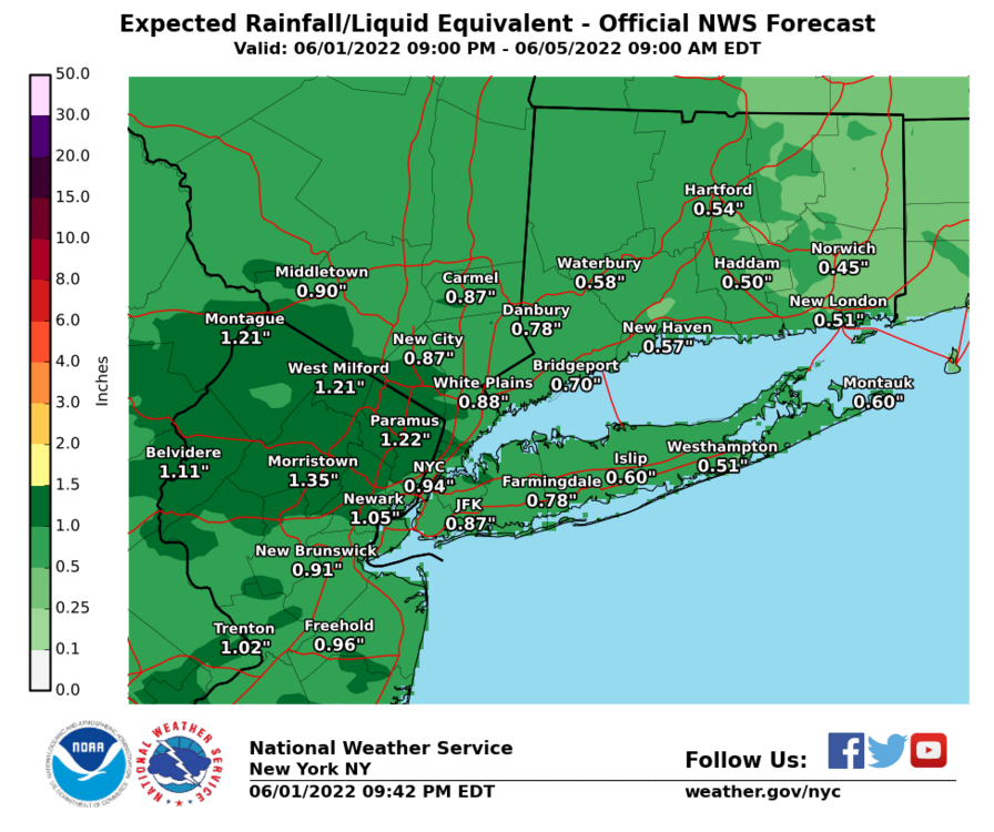
0.91” here.
-
Yup the same here. Everything is too wet to mow.
-
.05” here.
-
I didn’t know the Wallkill River ran down to Nyack. This definitely looks like something that came upstream from there.
-

-
Formed over you and dumped here.
-
Interesting. My wife works in the town of Newburgh and they had heavy rain in the Fostertown road area. Basically just to your east.
-
A quick 0.69 in 30 minutes that developed basically overhead.
-
A quick 0.69 in 30 minutes with the shower that developed overhead.
-
Flood Advisory National Weather Service New York NY 309 PM EDT Thu Jun 2 2022 NJC003-031-NYC071-087-022100- /O.NEW.KOKX.FA.Y.0029.220602T1909Z-220602T2100Z/ /00000.N.ER.000000T0000Z.000000T0000Z.000000T0000Z.OO/ Bergen NJ-Passaic NJ-Orange NY-Rockland NY- 309 PM EDT Thu Jun 2 2022 ...FLOOD ADVISORY IN EFFECT UNTIL 5 PM EDT THIS AFTERNOON... * WHAT...Urban and small stream flooding caused by excessive rainfall is expected. * WHERE...Portions of northeast New Jersey and southeast New York, including the following counties, in northeast New Jersey, Bergen and Passaic. In southeast New York, Orange and Rockland. * WHEN...Until 500 PM EDT. * IMPACTS...Minor flooding in low-lying and poor drainage areas. * ADDITIONAL DETAILS... - At 307 PM EDT, Doppler radar indicated heavy rain. This will cause urban and small stream flooding. Between 0.5 and 1 inch of rain has fallen. - Additional rainfall amounts of 0.50 to 0.75 inches are expected over the area. - Some locations that will experience flooding include... Ringwood, Sloatsburg and Tuxedo Park.
-
Looks like the heavier stuff will be to our south today. Sun is fighting to come thru currently. A shower or two should be in our area this afternoon.
-
Wearing dark colored underwear might help with the visual part
-
Total of 0.91 yesterday.
-
0.91 in the bucket for yesterday.
-
0.71 so far with moderate rain currently. Have a little more to move thru yet.
-
I don’t think you will have any brownout’s any time soon. Hopefully the back yard doesn’t float away. 0.71 in the bucket so far and have a thundershower currently.
-
Agree. Nothing organized in what the models are showing. Scattered garden type showers. You could get lucky with a heavier shower. currrenty 91.
-
91.
-
DCA _ NYC _ BOS __ ORD _ ATL _ IAH ___ DEN _ PHX _ SEA 0.6 0.6 0.2 0.1 0.4 0.7 1.3 2.4 0.0 101 100 98 99 100 106 99 119 93
-
URGENT - IMMEDIATE BROADCAST REQUESTED Severe Thunderstorm Watch Number 278 NWS Storm Prediction Center Norman OK 1255 PM EDT Fri May 27 2022 The NWS Storm Prediction Center has issued a * Severe Thunderstorm Watch for portions of Delaware Eastern Maryland Southern and western New Jersey Southeastern Pennsylvania Coastal Waters * Effective this Friday afternoon and evening from 1255 PM until 700 PM EDT. * Primary threats include... Scattered damaging wind gusts to 65 mph possible A tornado or two possible SUMMARY...A line of storms will spread northeastward through the afternoon across southeast Pennsylvania into eastern Maryland, Delaware and New Jersey. Damaging winds will be the primary threat with bowing segments, though a tornado or two may also occur with embedded circulations in the line. The severe thunderstorm watch area is approximately along and 50 statute miles east and west of a line from 20 miles north northwest of Allentown PA to 55 miles south southwest of Dover DE. For a complete depiction of the watch see the associate
-
Route 22 runs north/south to those towns. Great hollow nature preserve and west mountain state forest might have some parking and views to observe from. I’m not sure on some exact locations tho.
-
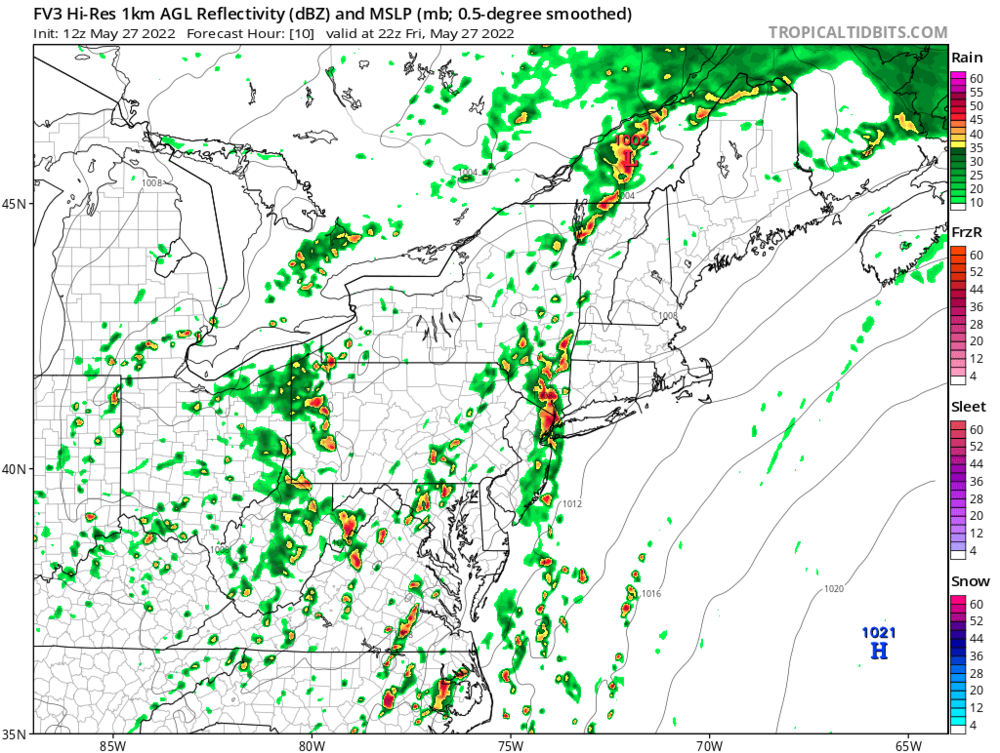
The FV3 is the most active I believe.

-
The Brewster and Wingdale areas have some open elevated areas where you can see some activity crossing the Hudson River. Agree tomorrow could also be fun up in central NE. Safe travels