

hudsonvalley21
-
Posts
4,070 -
Joined
-
Last visited
Content Type
Profiles
Blogs
Forums
American Weather
Media Demo
Store
Gallery
Posts posted by hudsonvalley21
-
-
2 hours ago, donsutherland1 said:
An extended period of generally cooler than normal temperatures is ongoing. No return to summerlike heat is likely through at least mid-month.
Tomorrow will be partly sunny and pleasantly warm. However, thick smoke from ongoing Canadian wildfires will create for unhealthy air. The smoke could be especially thick in and around the New York City area during the evening rush hour.
The latest ECMWF weeklies suggest that sustained warmer than normal conditions could develop during or after the second week of June.
The ENSO Region 1+2 anomaly was +2.3°C and the Region 3.4 anomaly was +0.8°C for the week centered around May 31. For the past six weeks, the ENSO Region 1+2 anomaly has averaged +2.25°C and the ENSO Region 3.4 anomaly has averaged +0.50°C. El Niño conditions are developing.
The SOI was -7.24 today.
The preliminary Arctic Oscillation (AO) was -1.316 today.
On June 3 the MJO data was not available. The June 2-adjusted amplitude was 1.205 (RMM) in Phase 1.
Upton’s thoughts and an Air Quality Alert was posted this afternoon for some sections of the forecast area.
Area Forecast Discussion National Weather Service New York NY 824 PM EDT Mon Jun 5 2023
NEAR TERM /UNTIL 6 AM TUESDAY MORNING/... The band of showers rotating through New London County and the twin forks of Long Island is a little later, and updated the probabilities to keep a chance through 01Z. Also updated the sky cover to expand coverage westward into northeastern New Jersey based on latest satellite. Otherwise forecast is on track, with minor updates for current temperatures. An upper level trough over the northeast supports the deepening of a surface low pressure system over the Canadian Maritimes through tonight and into the middle of the week. A wave of energy embedded in the trough dives south into Western New York tonight and into early Tuesday. Lows tonight will be in the 50s with the warmest locations at the coast and near NYC. Wildfires in Quebec are producing a significant amount of smoke that will make its way over the area tonight and into the day on Tuesday. While much of the smoke should be above the surface, there will likely be noticeably hazy skies on Tuesday with a low chance of some patchy smoke near the surface, as indicated by the HRRR smoke model fields.
-
 1
1
-
-
2 hours ago, IrishRob17 said:
.01, mark me up on the big board
Zilch here. 94 was also the high.
-
1
-
-
The smoke from Canada was pretty noticeable by haze and smell today.
82/45
-
1
-
-
DCA _ NYC _ BOS __ ORD _ ATL _ IAH ___ DEN _ PHX _ SEA
0.4 0.7 0.6 1.3 1.8 1.0 1.4. 1.9 1.1
101 98 95 100 102 105 97 121 93
-
 1
1
-
-
5 hours ago, Juliancolton said:
Looks like upper 30s again tonight.

Wide spread of low temps overnight.
-
1
-
-
19 minutes ago, BxEngine said:
Ooh actual raindrops!
-
 1
1
-
-
5 hours ago, IrishRob17 said:
We'll see about this...


-
-
Freeze Warning
URGENT - WEATHER MESSAGE National Weather Service New York NY 354 PM EDT Wed May 17 2023 NYZ067-181000- /O.CON.KOKX.FZ.W.0001.230518T0500Z-230518T1200Z/ Orange- 354 PM EDT Wed May 17 2023 ...FREEZE WARNING REMAINS IN EFFECT FROM 1 AM TO 8 AM EDT THURSDAY... * WHAT...Near freezing to sub-freezing temperatures expected. * WHERE...Orange County. * WHEN...From 1 AM to 8 AM EDT Thursday. * IMPACTS...Frost and freeze conditions will kill crops, other sensitive vegetation and possibly damage unprotected outdoor plumbing. PRECAUTIONARY/PREPAREDNESS ACTIONS... Take steps now to protect tender plants from the cold. To prevent freezing and possible bursting of outdoor water pipes they should be wrapped, drained, or allowed to drip slowly. Those that have in-ground sprinkler systems should drain them and cover above- ground pipes to protect them from freezing.
-
1
-
-
27 minutes ago, IrishRob17 said:
That damn Canadian smoke, ugh
It also seems to sink to the surface at night and stinks out the area. Had to close the windows a few times.
-
1.12” so far here for the last 24hrs.
-
DCA -0.3
NYC -0.4
BOS -0.2
ORD +0.2
ATL -0.2
IAH -0.6
DEN +1.8
PHX +1.8
SEA +0.4
-
10 hours ago, Hitman said:
got down to 34f this morning.
32 here
-
14 hours ago, BxEngine said:
Now that i think about it….i dont think ive ever even been on main street in goshen. Which is kinda odd considering how much time ive spent in orange through the years at breweries wineries and friends parties etc.
I have the same memory issues after tossing back a few too many.
")
-
2
-
-
55 minutes ago, Stormlover74 said:
And another 1 to 2 on Monday
-
1
-
-
2 hours ago, IrishRob17 said:
My bald head was pelted with ice as I was walking down Main Street in Goshen about 30 mins ago.
Interesting, over on the east side of the county, no event here.
-
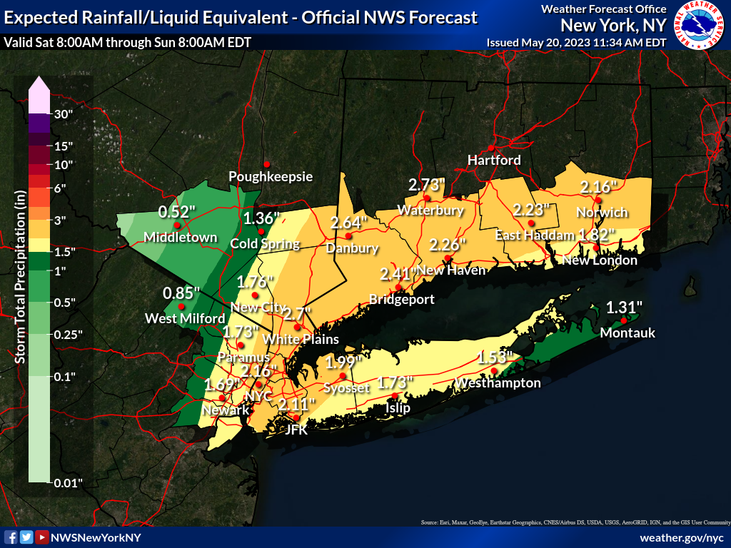
1.99” in the Davis for the event total from last night thru midday today.
-
2 hours ago, gravitylover said:
This rain is the real deal. The thunder rocked the house a few minutes ago and the dog got all worried. Lightning and sharp cracks now
") Looks like the fire danger is going down here.
Looks like the fire danger is going down here.
Same here a welcome relief for those brush fires. 0.86 in the bucket for today.
-
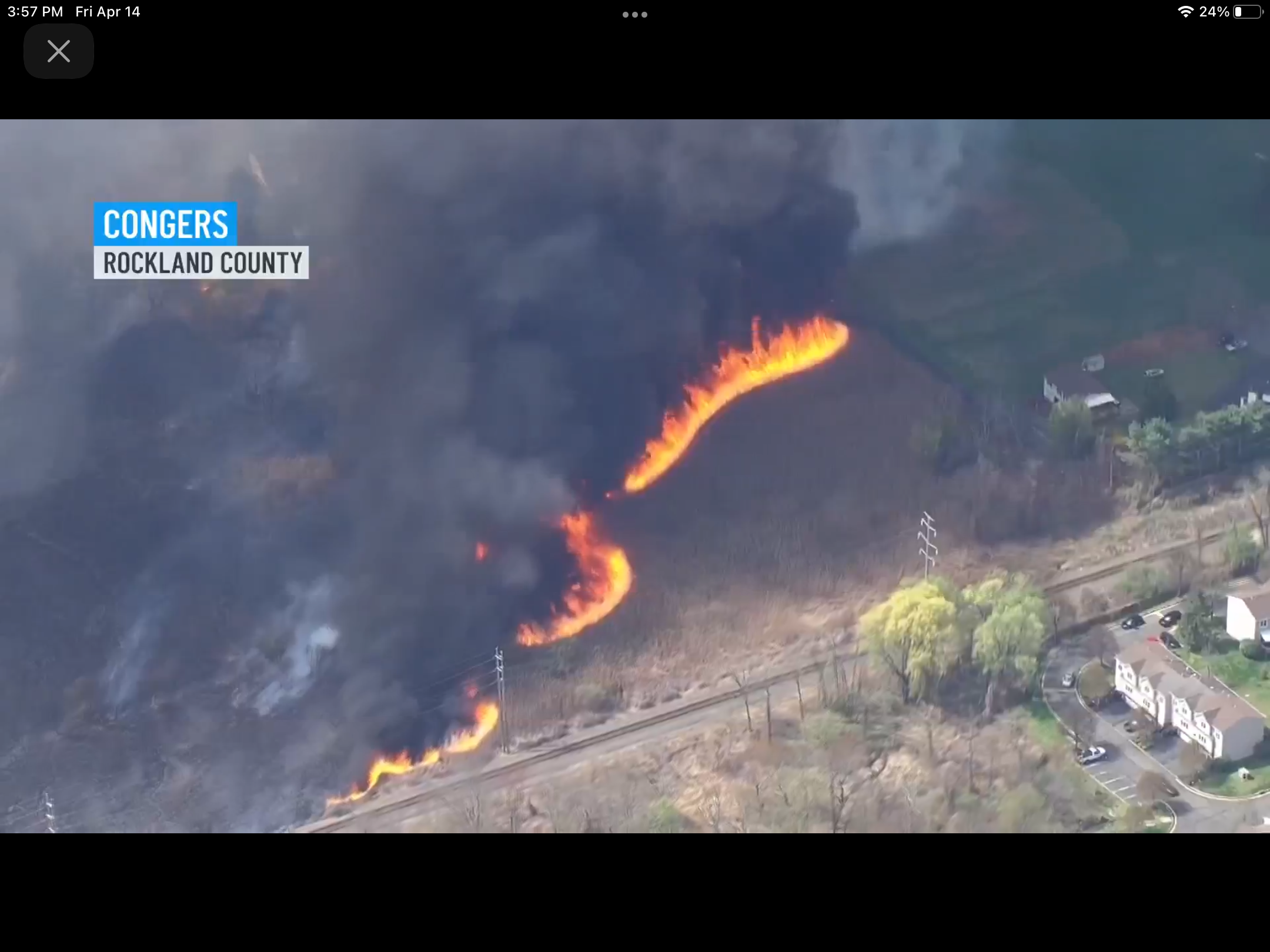
14 minutes ago, IrishRob17 said:
@BxEngineI hope that big brush fire isn't near you or yours. I just watched some video, my guess is a train caused that one
News was just stating that CSX train was the cause
-
2
-
-
From news4 New York

-
2
-
-
1 hour ago, IrishRob17 said:
After a low of 54, made it to 93 for a high, so close to another 40 degree swing. Sitting at 90 now.
Nice, I’m at 91 currently, that was my high for yesterday. Low of 59 this morning made the same 40 degree swing. Forecast high for tomorrow is 71 back to reality I guess.
-
2
-
-
On 4/2/2023 at 5:03 AM, IrishRob17 said:
KMGJ did gust to 49 during one of the windier bursts when the showers were working through.
I was at the Easter egg hunt at the Social Island farm in Goshen Sunday morning. It was 41 degrees with a wind gusting in the 40’s. Amazing too see the black dirt blowing around. The conditions didn’t slow down the kids a bit.
-
2
-
-
2 hours ago, IrishRob17 said:
You had that much rain...AND thunder?!! Had a couple periods of gusty winds that over-performed in comparison to its radar presentation
The wind changed from the west around 2pm along with the dewpts and humidity dropping rapidly put the end of the show for us folks up this way.
-
8 minutes ago, Stormlover74 said:
But they haven't extended that east yet
No and the dewpts are dropping. Currently 41 at KSWF. It was at 57 at 1pm when the wind shifted more westerly.
edit, the humidity was at 78% now it’s 41%.
-
2
-


June 2023
in New York City Metro
Posted
Thunderstorm currently here near KSWF. moving south south/eastward.