hudsonvalley21
-
Posts
4,033 -
Joined
-
Last visited
Content Type
Profiles
Blogs
Forums
American Weather
Media Demo
Store
Gallery
Everything posted by hudsonvalley21
-
Great to see. Trees and vegetation are starting up and the moisture is well needed.
-
April DCA _ NYC _ BOS __ ORD _ ATL _ IAH ___ DEN _ PHX _ SEA 1.2 1.7 1.5 0.2 1.9 1.8 0.9 1.8 0.1
-
Up to 1.16” with drizzle currently and 46 degrees.
-
1.09” here.
-
Upton’s is thinking that we’re going to get some decent rain according to their AFD. Radar looks just ok currently we’ll see in a couple of hours. A section of their AFD, NEAR TERM /THROUGH MONDAY/... A line of convection across eastern PA and upstate NY along a prefrontal trough will continue to weaken as it pushes east towards the area this evening. Strong onshore flow will push stable maritime air inland as the this convection pushes east. The latest SPC mesoanalysis indicated no surface instability over the area, which also gives confidence the line will continue to weaken as it approaches. The prefrontal trough and associated cold front will move into the region tonight. There will still be showers and embedded elevated thunder with the aforementioned weakening convective line, but it appears a resurgence of showers will occur from southwest to northeast across the area with strengthening low level jet in combination with increasing upper divergence from a an approaching jet streak to our northwest. This will likely induce a weak wave of the frontal boundary, which will increase convergence and lift overnight. While shower activity will initially be limited early this evening, moderate to locally heavy showers are expected to increase in coverage late this evening into the overnight hours. PWATs range anywhere from 1.3-1.6 inches supporting potential for some locally heavy downpours. Still think a few rumbles of thunder are possible, but elevated instability is minimal overnight. HRRR has indicated a marginal MUCAPE even across eastern Long Island overnight, so will mention slight chance of thunder there as well. The heaviest rain may shift east of the NYC metro by early Monday morning with a steadier stratiform rain from the city on NW. Peak rainfall rates from 0.25 to 0.50 inches per hour seem most likely although a few downpours could briefly be a bit higher up to 1 inch per hour. The main concern tonight into early Monday will be from minor urban and poor drainage flooding. Eastern Long Island and southeast Connecticut stand the best shot at seeing a longer duration of heavier downpours, so cannot completely rule out a localized instance of flash flooding here. Rainfall totals around 1.5" to 2.50" are forecast, highest across eastern portions of the area. Locally higher amounts cannot be ruled out where the heaviest downpours occur.
-
Absolutely . That’s a long lay line, friction loss is a definite.
-
.88
-
Good luck with the curling competition
-
Pure stupidity, some departments should not be messed with. What’s next cutting Air Traffic Controllers? when it comes to public safety all you need is one blip to have a casualty. With Tornado season approaching, could you imagine staffing cuts at SPC?
-
March BOS +2.3 NYC +2.1 DCA +3.3 ORD +2.9 ATL +3.6 IAH +3.5 DEN +1.8 PHX -0.3 SEA -0.6
-
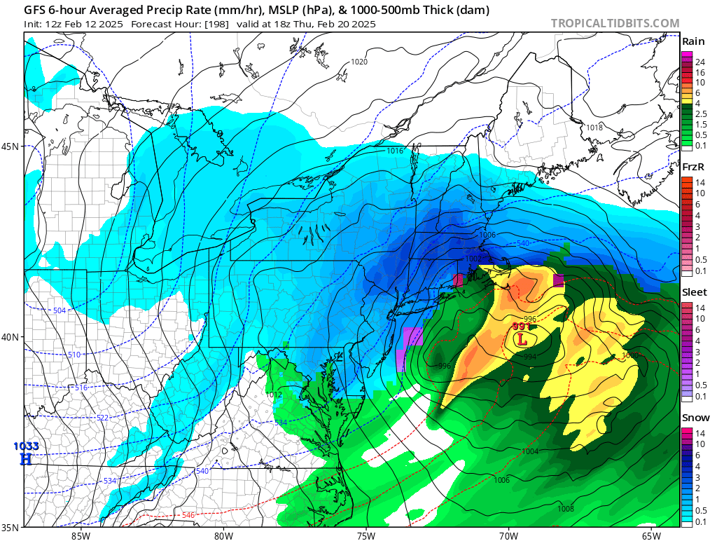
Thanks Walt, we’ll see what happens with this time period. The 18z GFS today is showing 2 events in this timeframe. This could be the grand finale for the snow possibility’s this season. Subject to change as always
-
Must be the upper crust or the greatest G.O.A.T.S.

-
Steady snow and 19/18 with 0.3” on all surfaces. Current radar is looking like it might continue for a while more, maybe we could get an inch up here in Orange County. Upton’s AFD NEAR TERM /UNTIL 6 AM FRIDAY MORNING/... As an upper low passes just south and an associated weak sfc trough moves through, snow showers have begun to overspread from west to east across NYC, NE NJ, western Long Island and the lower Hudson Valley. Forecast continues to carry likely PoP for those areas, and also have chance PoP into parts of southern CT mainly over Fairfield County and toward the coast. QPF remains light, less than 1/10 inch in general, and corresponding snowfall amounts should largely remain from a coating to around a half inch. Can`t rule out an isolated 1 inch total in the higher elevations north/west of NYC and across parts of western Long Island where forcing with the upper level low will be stronger. Some minor travel impacts and slick spots are possible this evening. Still, some locales may not see any snow whatsoever, or just a few flurries, largely staying mainly dry and overcast instead, especially into interior southern CT. Clouds thin out regardless overnight as the upper low shifts offshore and drier air works in. NW flow increases tonight as the pressure gradient tightens between the offshore low and the strong inland high, which should preclude decoupling. Low temps range from the mid teens inland, to either side of 20 in NYC and along the coast, with wind chills in the single digits most places, and as low as 0 in spots well inland.
-

-
At this time be happy there’s an event possible and there’s plenty of time to see who gets what and when. Let’s get this first event thru here and see what things look like Monday for Thursday then.
-
There were a bunch of western solutions that Tip just posted in the NE Forum.
-
Agree, the model runs have been flip flopping for the last couple of weeks. I think everyone is gun shy and not very confident on pulling the trigger. You would think that one of these runs would hone in and hold firm for 5-7 days out. What ever we get would definitely add needed help to the reservoirs.
-
Would that be from the 00z run?
-
Thanks for the heads up Walt. Then we go cold Sunday night with the cold front that comes thru keeping the frozen accumulations that we have left (especially for us interior folks) for some time and whatever happens around the 20th.
-
And now it’s 8 days out. It’s seldom this far out that it verifies. Once in a while a dog gets its bone. The million dollar question is when.

-
All snow here quick dusting on all surfaces. 29/16