FallsLake
-
Posts
6,317 -
Joined
-
Last visited
Content Type
Profiles
Blogs
Forums
American Weather
Media Demo
Store
Gallery
Everything posted by FallsLake
-
There's always a chance a big storm could hit, but statistically not likely. Many (many) years back I took a trip with my parents to Colorado. It was early September and it was great; right before all the trees started changing colors and the cold took over. Drove up to Pikes Peak and traveled through the high elevation areas west of Colorado Springs (..Cripple Creek area). Later in life my wife and I camped in the Rocky Mountains National Park; but funny that was in July and we had a great time then as well. So basically I wouldn't worry about the weather. I would go when it best fits your time and budget.
-
That's great! It's going to be nice to get you back to the area; and to have you as a RDU person. You know this area well, we can score big and bust big.
-
Most definitely do not take it seriously. Just something to track. If what the euro or the earlier ICON runs have the right look there could be some mountain snows.
-
Lol..the 18z FV3 says Orangeburg could be a little too far NW to get snow (south GA, coastal SC, & SE NC).
-
Man the 18z GFS is close to something big. Knowing our luck, we'll get the perfect setup but nothing wintery (like the November storm). Just too late in the year.
-
The 12z ICON has joined the euro on showing a significant elevation (mountains/foothills) winter storm. It also shows your area getting some snow. The 12z FV3 continues to show a wintery mix for areas farther east; and now the 12z GFS is starting to show something. Bets still on the euro and now the ICON. Main reason is time of year (climatology). Still very reasonable to get mountain snows; whereas other areas it's very rare.
-
I absolutely agree.
-
Here's a euro link: https://weather.us/model-charts/euro/north-carolina/significant-weather/20190328-2200z.html
-
Euro is more of a mountains/foothills event. Mack would actually get a little sleet before things shifted northward into the higher elevations of NC and VA. Of course we would like to see the FV3 verify but I would put my bets on the euro.
-
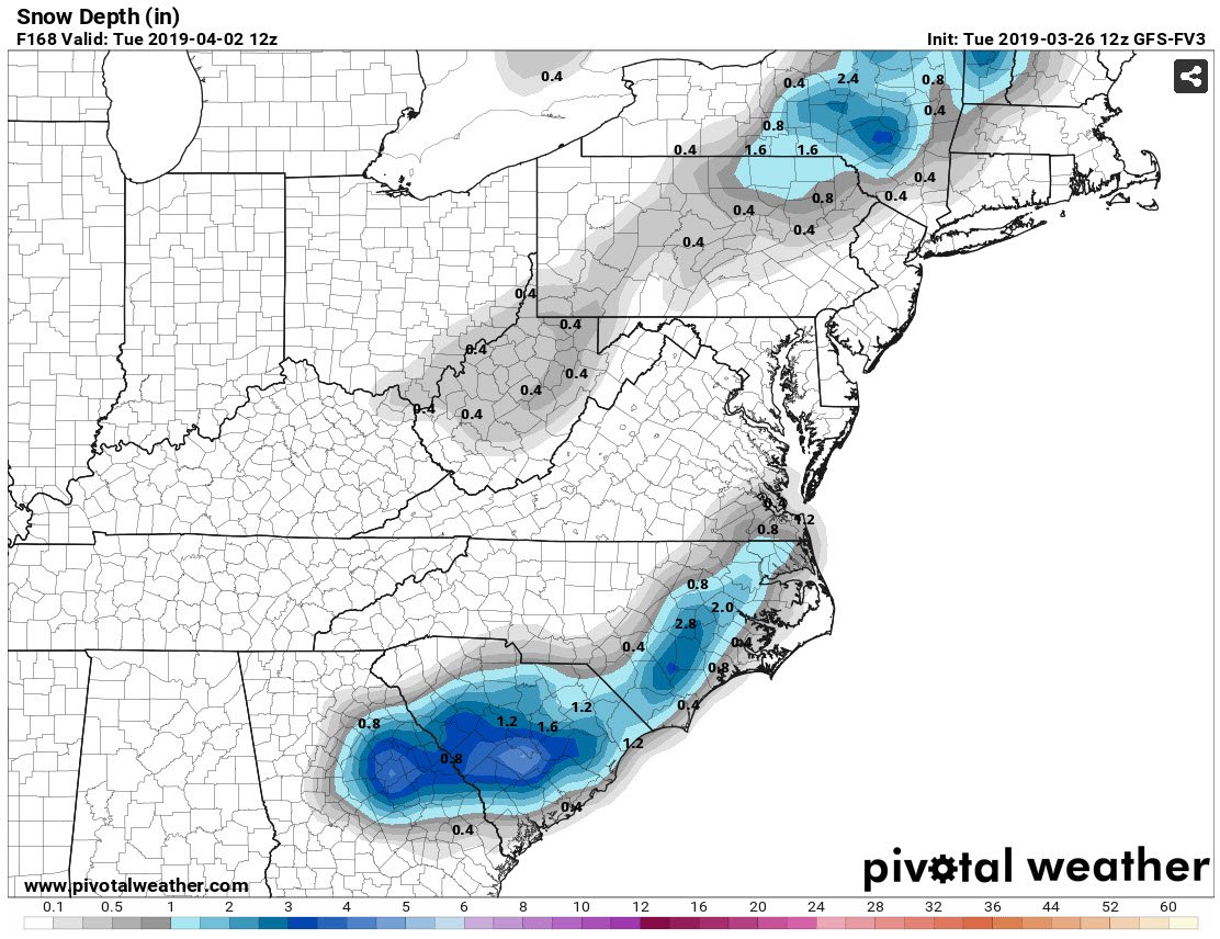
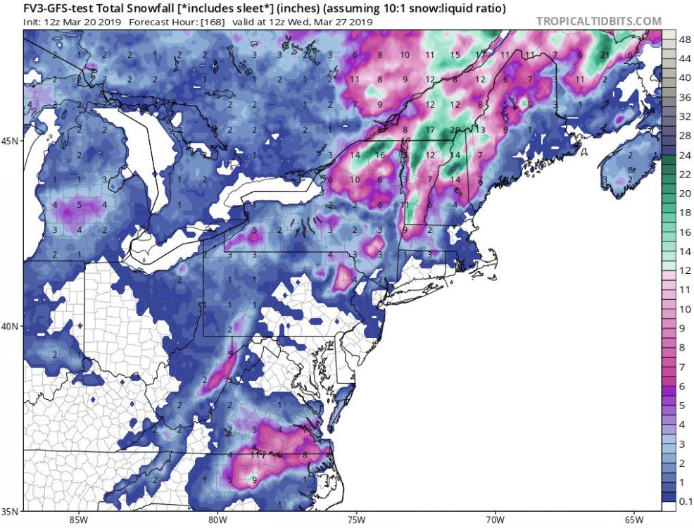
I'm surprised Orangeburg is not all over this. 12z FV3 snow depth at hour 168:

-
Man, this place is hot! We do have some frost/freezes coming for tomorrow night: SHORT TERM /TUESDAY AND TUESDAY NIGHT/... As of 355 PM Monday... 1030-1035 mb continental Polar high pressure will build from the Great Lakes to the nrn middle Atlantic states, while ridging swd in the lee of the Appalachians, Tue-Tue night. This high will be led swd by a secondary surface cold front, analyzed at 19Z from Long Island wwd across nrn NJ and s-cntl PA, forecast to cross cntl NC Tue morning. Related CAA and nely breeze/low level flow will yield unseasonably cool temperatures mainly in the lwr-mid 50s, despite a mostly sunny afternoon that will follow north to south clearing of the preceding post-frontal band of stratocumulus. A shortwave trough will dig from the cntl High Plains this afternoon, sewd and offshore the GA/FL coast by Wed morning, with associated cloudiness that will remain south of cntl NC. Skies will consequently remain clear; and given the presence of the aforementioned strong surface ridge, strong radiational cooling will result. Freezing temperatures are consequently likely throughout cntl NC overnight (26-32 degrees), down a few degrees from previous forecasts. This will likely necessitate a progression of Freeze Watches/Warnings in subsequent forecast issuances where the growing season has officially begun, relative to the climatological median date of the last Spring freeze (ie. the ern Coastal Plain and Sandhills).
-
I saw that...We do have a little time for this to trend better.
-
Hard freeze coming Saturday night: RAH: A hard freeze is expected over portions of the Piedmont Saturday night, with a frost and light freeze in the SE zones that have begun the Frost/Freeze program. This will likely lead to Freeze Warnings in these areas. Clear skies, calm winds, and exceptional radiational cooling under the Continental Polar air mass will lead to lows in the 27-30 degree range over the Piedmont, with lower 30s in the SE.
-
Yeah, we can still track freeze/frost potentials.
-
Well c'est la vie..... Our storm is gone. As happened many times this winter, once it got to the day 5 mark the models lose it. You can say the models are now better closer to events; or I think they've become worse in the medium range. A lesson (or rule) for next winter; storms have to be modeled less than day 5 before taken seriously.
-
RAH: Monday through Wednesday, low confidence as model spread continues. We will carry a good chance of showers late Monday into Tuesday. However the storm track and timing are still in debate, along with the strength. For now, a low pressure track from the TN valley east across SC or far southern NC is favored, with cold high pressure to the north acting as a block from a more northward track. Most likely the temperatures will remain fairly cool, except possibly in the SE zones (if the warm sector can advance into that region). QPF could be significant again (1+ inch), but too early to pin this down. Much more on this potential system in the coming days.
-
Yeah it's just fun tracking something. I wont lose sleep if/when this thing disappears.
-
Or to make more folks happy, expand the coverage.
-
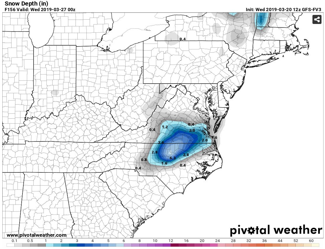
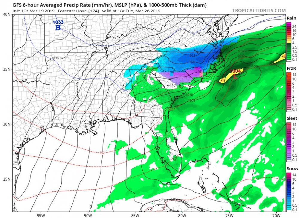
Snow depth:

-
12z FV3 back to showing a big event. Has RDU with a foot (10:1). Do I believe it?....No, but it's interesting to track.
-
6z GFS has backed off some but still shows frozen precip over northeastern NC into SE VA. The FV3 has less but is showing more potential then previous runs. My take looking at the current models, we could see some change over to snow for north-central NC eastwards into the north-central coastal plain then up into SE VA. But I wouldn't expect much accumulations.
-
18z GFS still has the storm. We know it's got to be right, it has the Wake County split....

-
From RAH: The next wx system will come during the first half of next week. It`s an interesting system with models depicting a closed H5 low dropping SEWD from the Central Plains to across the Carolinas. Thermo profiles would suggest perhaps a late-season p-type concern across the Piedmont, but given that this system is so late in the forecast period, inevitably the details will change below now and then. Will continue to monitor model trends, and for now will show increasing PoPs during this time.
-
This would be nice...
-
The 12 GFS continues to show the storm, but the FV3 pushed the low through too quick which didn't allow the high to the north push down in time to change rain over to snow. But that's just details. Players are on the field; just don't know how good they are....