FallsLake
-
Posts
6,317 -
Joined
-
Last visited
Content Type
Profiles
Blogs
Forums
American Weather
Media Demo
Store
Gallery
Everything posted by FallsLake
-
Not sure if it was last year or the year before that, we had a storm modeled with high amounts throughout the Triangle (and down east). The models failed to see the warm nose and many folks SE of our location saw a lot of rain mixture. The NAM did see this late in the game but most folks ignored it. **I think we need to pay more attention to the short term models from this point on.
-
But overall it's more of a monster winter storm look because of the colder surface temps. Major ice storm down through central SC.
-
Everybody in my office always ask me what the weathers going to do. I think right now, I'll just give them the RAH grid forecast. This should make it real clear: Saturday Night A chance of rain and snow between 1am and 3am, then a chance of rain, snow, and sleet after 3am. Cloudy, with a low around 31. Chance of precipitation is 30%. New precipitation amounts between a tenth and quarter of an inch possible. Sunday Rain, snow, freezing rain, and sleet likely before 11am, then rain and snow likely between 11am and 1pm, then rain after 1pm. High near 37. Chance of precipitation is 80%. Sunday Night Snow, possibly mixed with rain and sleet before 7pm, then rain and sleet likely. Low around 33. Chance of precipitation is 80%. Monday A chance of rain and snow before 9am, then a chance of rain. Cloudy, with a high near 41. Chance of precipitation is 50%. Monday Night A chance of rain, mixing with snow after 8pm, then gradually ending. Mostly cloudy, with a low around 29. Chance of precipitation is 30%.
-
Elizabeth Gardner (WRAL) has a nice video: https://www.wral.com/news/local/video/18043784/
-
The FV3-GFS is coming in slightly warmer with surface and 850 temps but still a monster. It's out to hr 96. Just looking at the maps it looks like RDU gets over 1" liquid equivalent of snow before any type of mixing.
-
Some secondary thoughts, ground temps should at least be on the cool side for this event. We're going to have a couple of days with highs in the 40s and lows in the 20s. That should helps set the stage for this storm. **I'm currently at 31 degrees, going to be a good freeze tonight.
-
I'm pulling for those snow totals to increase all the way to the coast. I hate seeing the cutoff line running through our area. Good to have a cushion.
-
I hate this, but I think we need to take them seriously. Models would argue that at least the NW Piedmont gets warning criteria totals, but they are really good mets. I hope they're wrong but have to stay cautious until they jump on board.
-
Just had a chance to look at the 18z NAM. If the CAD and dew points are correct, this will be a major storm not just for the western/central folks but for folks into the coastal plain.
-
Lol...yep we need to cash that out now and run.
-
Nice run for so far (hr 96) for our area. We will want to see this transfer to the SE to the coast for us to stay wintery.
-
I agree, as long as it didn't have any "erroneous" issues it's another possible outcome.
-
It would be nice sometime to get a winter storm that drops similar (large)amounts of snow across the whole county.
-
For RDU folks, this was a better run. As currently modeled, the farther west and north from Raleigh the better. **If it's right I barely stay all snow through the event. I've seen this too many time.
-
12z ICON was slightly better (at least for RDU) then 6z. ~3 to 4" in the Triangle before a switch over.
-
12z NAM seems to be catching back up to strength (1041) at hour 75. But the push of cold has backed slightly off.
-
As Grit just stated, if there is more ice then I think we get a big storm. If this is a miller a snow/rain storm we may only get that 1" (...then it will wash away).
-
Lol...I'll take my >1" and be happy. Kidding aside, I would expect a little more then 1" but that is a possibility.
-
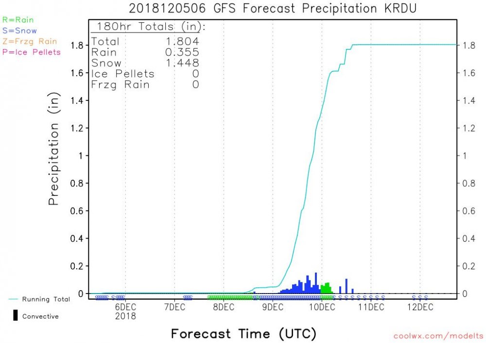
Here's RDU:
-
We always live on the edge. As always there's going to be transition lines running through Wake County. I think if the GFS(s)/euro are right, we're looking at some front end snow changing to rain, and then back to a little snow. Honestly I would think a few inches at best (messy). If the NAMs depiction of the CAD is right, I think we still mix but it wont be plain rain. More sleet and freezing rain, which would end up a significant storm for us.
-
True. I'm hoping the next model runs start to lean towards it's depiction.
-
With that look it's still perfect. I dare say anything stronger would suppress the storm way south.
-
I need it to shift north a little.....
-
Yep, this is our hobby. It's like playing a board game where you roll the dice every 6 hours.
-
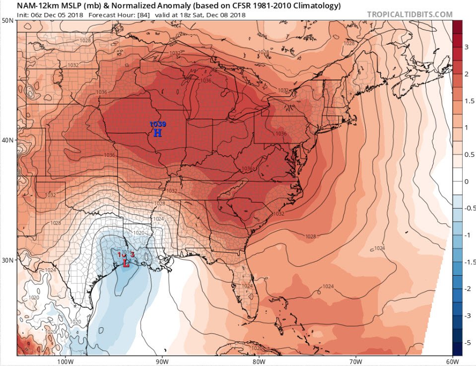
The 6z NAM is beautiful. Very pronounced CAD with an ideal high and low setup: