FallsLake
-
Posts
6,317 -
Joined
-
Last visited
Content Type
Profiles
Blogs
Forums
American Weather
Media Demo
Store
Gallery
Everything posted by FallsLake
-
Your right, we've lost many threats ~ day 7. It would be great if the models keep/start showing a storm the next two days.
-
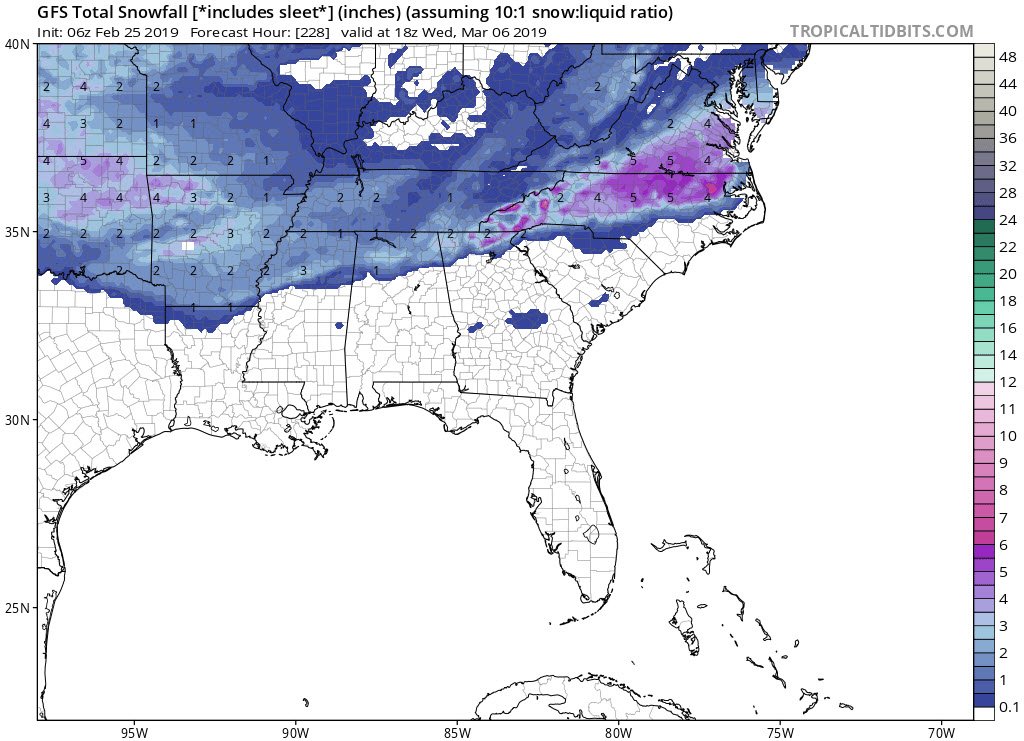
Here's the 6z GFS snow map:

-
Not sure if it's a trend. It seems like the difference between the 0z and 6z GFS is that the 6z develops a storm much earlier. Now if you're looking at yesterdays 18z, there was a shift north between that run and 0z. But it seems the 6z GFS has leaned towards the euro of developing a storm on day 8.
-
This would be the cold we need to setup the potential storm afterwards: From RAH: The forecast over the weekend is uncertain, yet the next system should bring more rain into the weekend - followed by a very cold high that may nose into our region (potentially more aggressively than most of the cold highs that have affected the upper Mid-West into the Ohio Valley so for this winter season).
-
So, the 0z euro had two different potential storms from day 8 to 10. Both didn't produce much but again it wouldn't take much for that to change. At this time range we have to expect big difference between each model run (storm, no storm, storm.....). In a couple of days we would expect it to settle down some; hopefully showing a storm. The 6z GFS has a nice snow storm for a large portion of NC up into VA. FV3 has the storm but it's suppressed. So just looking at these three models (..considering GFS and FV3 different) there's definitely still a strong storm signal.
-
The big thing is it still shows a storm. The 18z FV3 has a light event, which wouldn't take much to be much larger (but again details....). So basically all major models showing a potential storm at day 9.
-
^^A good run for the euro. Again don't look at the details; all that matters is it shows a storm with available cold air (in the area). But if you do want to see the details (which will change next run), here you go: https://weather.us/model-charts/euro/2019022412/north-carolina/significant-weather/20190306-0600z.html
-
Yeah, that was a good run for both the GFS, Fv3 and CMC. Can't look at the details (past day 7); just know a storm with available cold (in the area) is showing.
-
Yeah the euro is hinting at this along with the 6z FV3. Of course the FV3 would then continue into a big winter storm at days 9/10/11.
-
That time period could be our last chance. We have a pretty defined winter period where we can get snow. Usually it's early December to early March. Of course folks can quote storms (...93) outside that range, but they're rare.
-
^^That would be funny to end up getting the two big winter storms in December and March, but basically nothing in January and February.
-
12z NAM at hour 51 has dew points in the upper teens in VA, low 20s across northern NC, mid 20s across N. SC and S. NC, and 20s to near 30 for a large part of SC and mid to N. Ga. We really want this to be about a category colder if your looking for a widespread ice storm. Of course there are many other things to think about, but if you have a strong established CAD (classic) I've always noticed you want dew points in the teens for my particular area. Western areas work a little differently but even there the lower the dew points in VA (..say low teens) the better. CAD can overperform with strength and cold. Just something to look for....
-
The FV3 came in a little colder for Tuesday (goes along with CMC). Looks like western and northern parts of NC, then up inti VA have a shot of seeing some wintery precip. We shouldn't get to excited. From RAH: Another disturbance and CAD event is expected to effect the area Tuesday afternoon/evening into Wednesday, with lingering affects into Thursday. This will result in rain spreading into the area Tuesday afternoon/evening into Wednesday, with lingering chances for precip into Thursday. A strong 1035+ surface high to the north/northeast will extend south/southwestward into central NC Tuesday into Wednesday before shifting eastward and well offshore by Wednesday night. Meanwhile, a complex low pressure system will approach from the southwest on Tuesday, with precip spreading into the on Tuesday afternoon/evening. Models have trended colder with low level thickness values/thermal profiles across central NC on Tuesday evening/night. In fact we may see a period of rain/mixed with snow across the Piedmont Tuesday night. However, no impacts are expected at this time, with temps expected to remain just above freezing during this time frame. As the warm moisture air continues surge into the area Tuesday night/early Wednesday morning expect any snow mixing in will turn to all rain thanks the the associated warm nose. We will need to keep a close eye on this time frame (Tuesday night into early Wednesday) as wet bulb temps are right around freezing. Given this have lowered temps Tuesday night into Wednesday, with lows Wednesday morning in the lower to mid 30s across the Piedmont to the upper 30s across the south. Highs Wednesday during the daytime are expected to range from the mid to upper 30s NW (maybe a bit too warm still) to the lower 50s far SE (very late in the day too).
-
Yep, if I was in NW NC up towards your area I would start looking at this closely. Even down towards my area there could be some brief mixing; which I would call a win.
-
12z GFS coming in a little colder. Looks like some mixed snow for N. NC up into VA. Maybe even a significant event for NW NC into VA.
-
RAH is keeping an eye on possibly a little bit of ice for NW and north portions of NC. Nothing that would cause any issues but it's all we got: SHORT TERM /SUNDAY AND SUNDAY NIGHT/... As of 228 AM Saturday... Rain and falling temperatures again Sunday. CAD appears that it will linger into Sunday. It will get reinforced as a 1025+ mb high is forecast to extend south into our Piedmont damming region (even into northeast GA) Sunday. The high is progressive to the north, cutting off our supply of cold and dry air Sunday afternoon from the north. However, the next southern branch wave will be moving in late Sunday morning through the afternoon, with presumably another cold rain. This presumption is confirmed by the forecast partial thicknesses that suggest the cold rain as well. However, the coldest ensemble runs of the models suggest that the surface wet bulb temperatures will be as low as 30 in the Triad to Roxboro Sunday afternoon into the evening. There may be some light icing on elevated surfaces (above the highway system) if this verifies. Otherwise. evaporative cooling of the 20s (dry) dew points in the NW and N Piedmont should again lead to falling temperatures in the damming region again Sunday as the rain falls. Highs 40 NW to some 50s SE, but falling into the lower 30s west and north and near 40 SE by late Sunday with the rain. POP near 100 percent, and QPF storm totals for round 2 in the 0.5 to 0.75 range ending Sunday night. &&
-
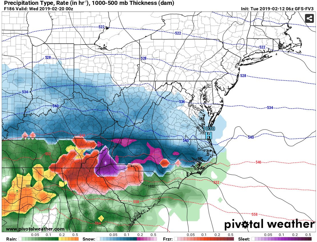
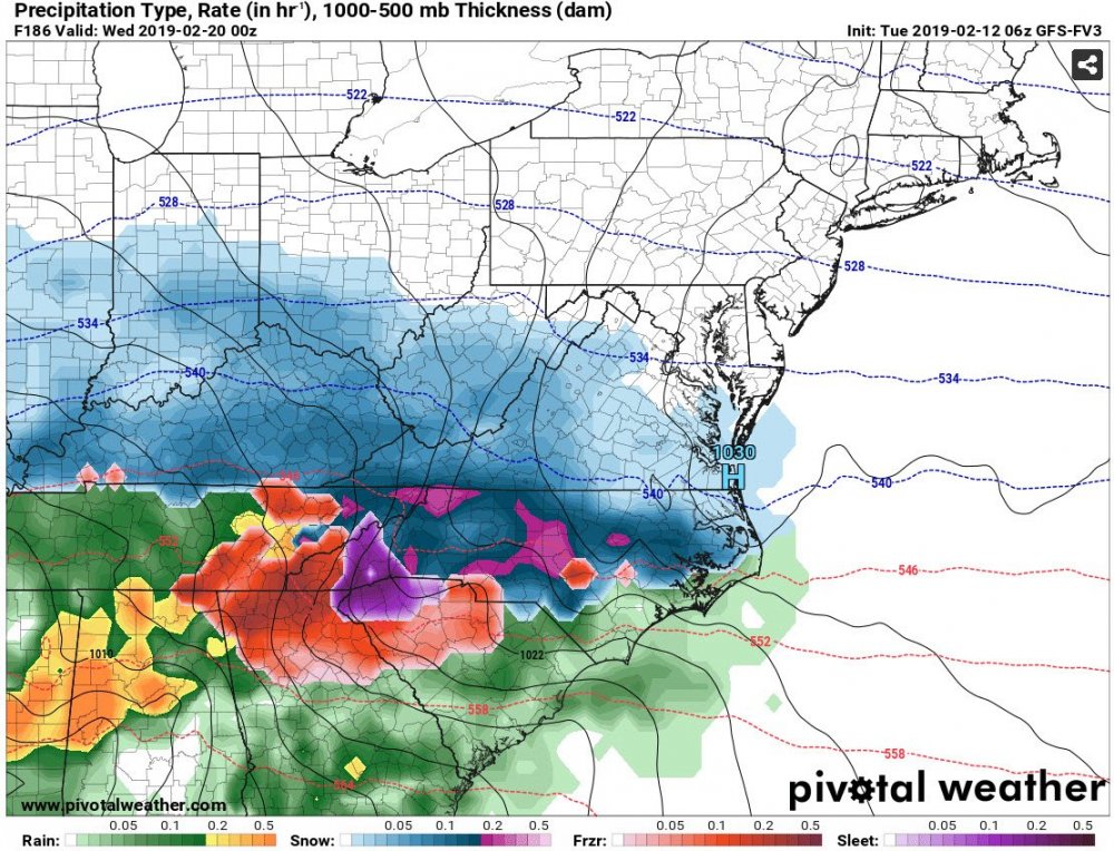
The FV3 shows many of us starting (switching briefly) as some kind of wintery precip before the rain takes over. But yeah, the snow/sleet amounts are over the top. This models still has some details to work out.
-
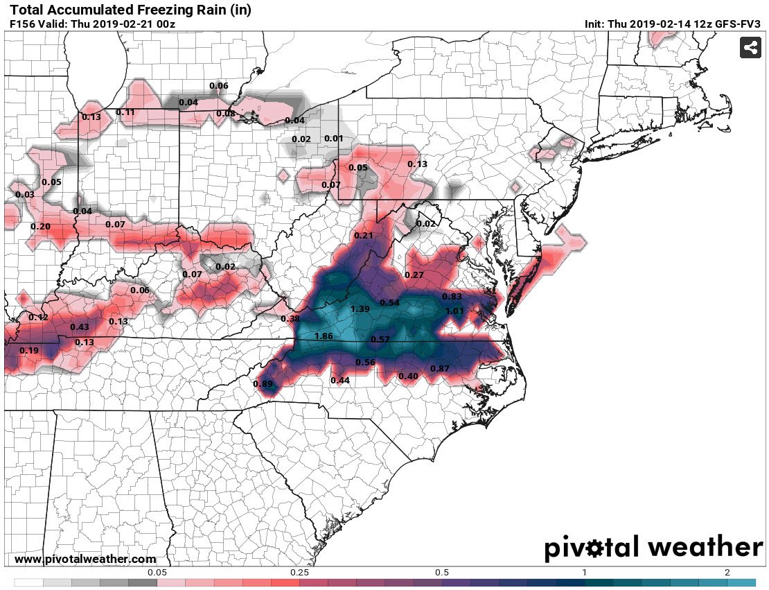
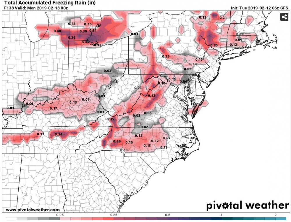
The 12z FV3 did come in a little colder for next weeks potential event. Would be significant ice for our region. But, I agree it hasn't done well lately. Freezing rain totals:

-
I bet the 12z euro helped them mention the possibility.
-
The euro is also in the same camp. Would be nice to see them come in colder at 12z.
-
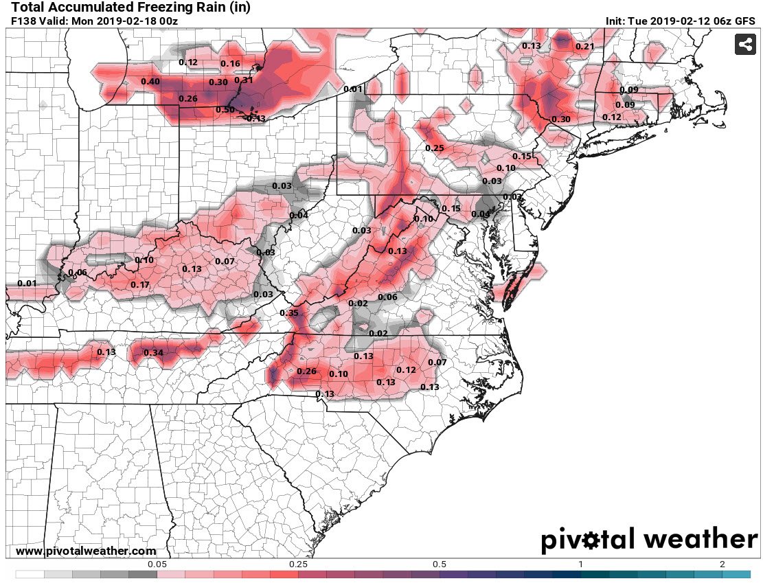
Yep that would correlate with the above FV3 map. The GFS also has a lighter event for this upcoming Sunday:
-
6z GFS and GFS/FV3 still have the day 7/8 storm. GFS looks like more of a NC storm whereas the FV3 would be a big storm for many on our board:
-
Problem is we're running out of time. This is the end game. Maybe have three weeks left to get a decent storm. Time to throw in the chips....
-
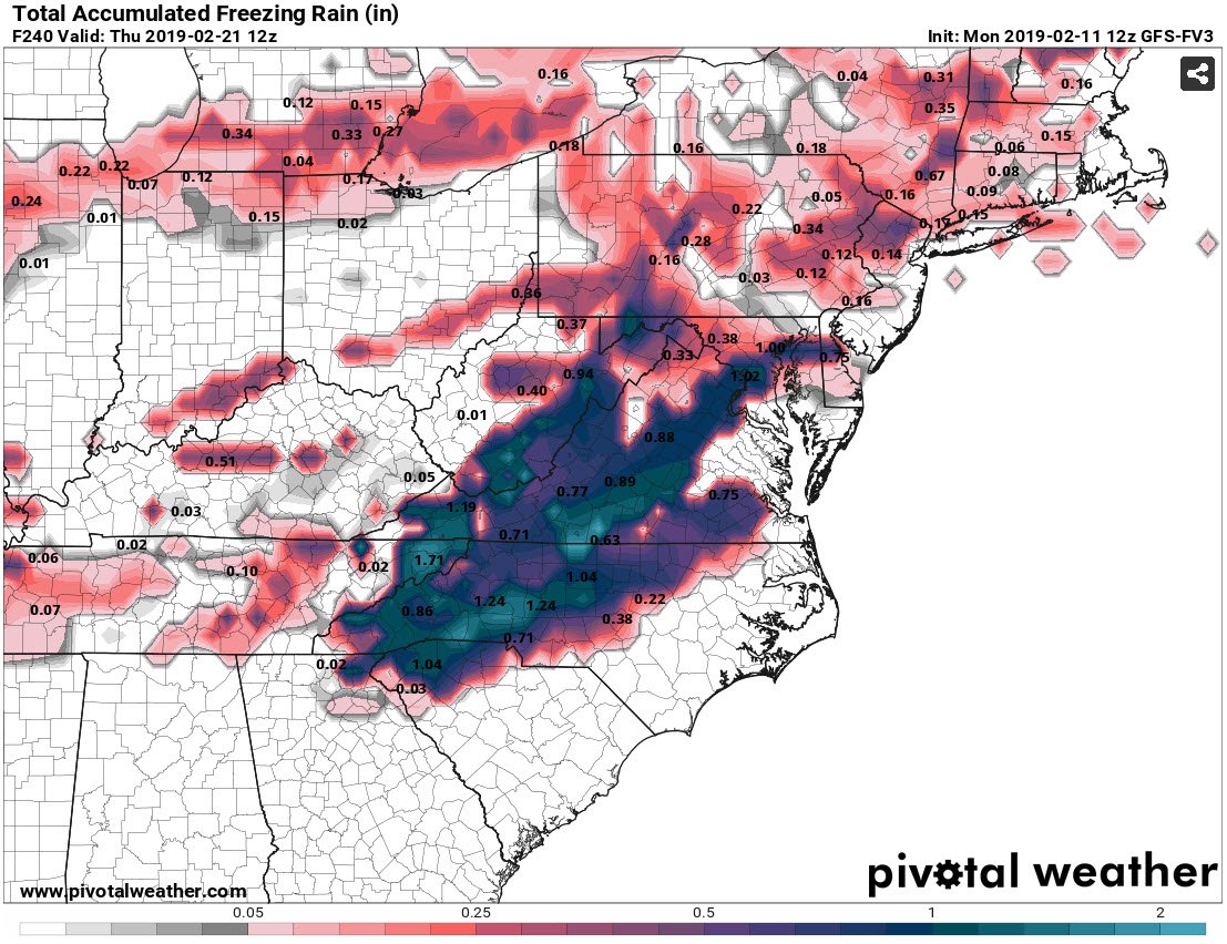
Yep, more ice would fall with the second system. Lots could go wrong with this setup, but I'm glad to see the potential. We're getting to the end of the season and need to see something materialize very soon. This is at hour 240 (with ice still occurring):

-
Yeah, we have one more opportunity for things to swing better (+PNA) by the end of the month. But I'm with you, the odds are not good at this point.