Torchageddon
-
Posts
1,409 -
Joined
-
Last visited
Content Type
Profiles
Blogs
Forums
American Weather
Media Demo
Store
Gallery
Everything posted by Torchageddon
-

March 2022 General Discussion
Torchageddon replied to SchaumburgStormer's topic in Lakes/Ohio Valley
The key 10 days of the Great March Heatwave were some of the happiest days I've had. -
March 2022 General Discussion
Torchageddon replied to SchaumburgStormer's topic in Lakes/Ohio Valley
Today's forecast here busted horribly, 13C for a high with 5 hours sunlight - instead got to 9C with less than 2 hours of sun. Somehow after this my point for tomorrow was raised to 18C, mainly sunny (after showing rain and 14C) . I took a screengrab of that this time, can't wait. -
March 2022 General Discussion
Torchageddon replied to SchaumburgStormer's topic in Lakes/Ohio Valley
For once I'm getting a locked-in LES band that is bringing whiteouts for the entire afternoon thus far. Among the most intense winter wx so late I've seen. Its the exact opposite of a decade ago when I had a severe thunderstorm and 70F temps, today the temp is falling midday to 15F feeling like -4F and heaviest snows of the winter . -
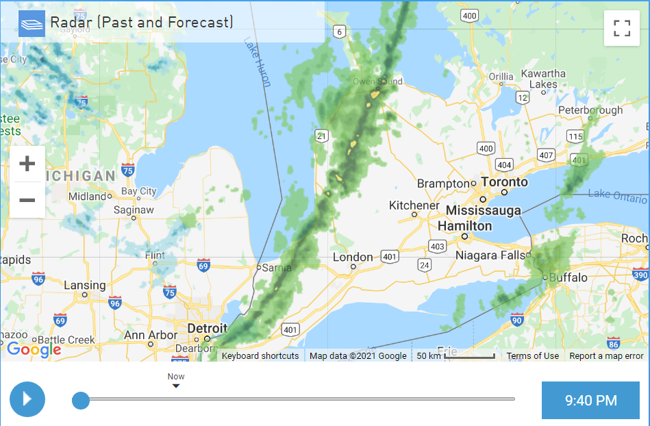
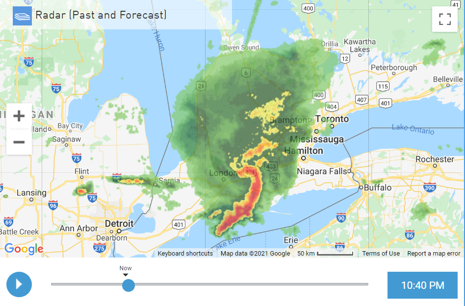
We had our 1 hour of winter fun for the season with the passage of 2 LES bands that brought whiteout conditions in Huron and Grey-Bruce counties (and eastwards towards Barrie). It wasn't quite the blizzard conditions I was hoping for compared to similar setups from other years, but seeing blue skies and the sun within minutes was once again a feature. This winter is still a 0 like the previous five. 30 mins of neat wx during a season is remarkably lame. The evolution of these bands is interesting on radar:
-
I was put under a blizzard warning as I'm near the lake, one of those diluted ones. Its pretty bad out right now so I'll have to get up early to see if it verifies. During the last few years the last 10 days of Feb seem to feature the worst of winter.
-
Temp in the last few hours has been rising fast, from 8am to 9:30 it went from 2C to 6C. I haven't seen rain since Nov.
-
I had my 17th t-storm of 2021 last night, had about 10 flashes of lightning with gusty winds when it was 4ºC. After the sharp squall line passed within minutes it went from rain to snow. Amazing to have 17 storms in any year.
-
Really great day today, clear blue skies with a high of 14C. Hard to get these this month. Still pales compared to last year's amazing heat event where I was over 20C for a few days - fond memories.
-
I'm up to 93mm or 3.66 inches of rain in the last 24 hours, likely the most I've ever documented imby within a 24h range. Forecast was showing 100mm today which is also a first, this is definitely the most substantial rain event I've experienced. I knew we were going to pay for those two days (which was last weekend) of cloudless warmth.
-
My overnight low was 20ºC which I have never seen this late except perhaps that hot spell in mid-late Sept 2017. I only had 20C+ minimums 3 times during this whole summer.
-
The 2nd Tuesday in a row of a tornado warning for Grey-Bruce/Huron county and this time I saw the rotation right at home! In the beginning I wasn't sure if I saw a funnel or just scud but I could briefly see the rotation just like I did in the Plains. It lined up with reports of rotating wall cloud north of Walkerton moving east. Then a new couplet must have formed to the south and OPP in Mount Forest reported a touchdown 30 minutes later around 7:30 pm. I had a lot more lightning and rain than last Tues. No hail for me. 4 waves of storms this evening and I'm up to an astounding 14 storms for the year This has been so far the most active September I've ever seen for storms and others concur. With all these tornado warnings this is getting insane .
-
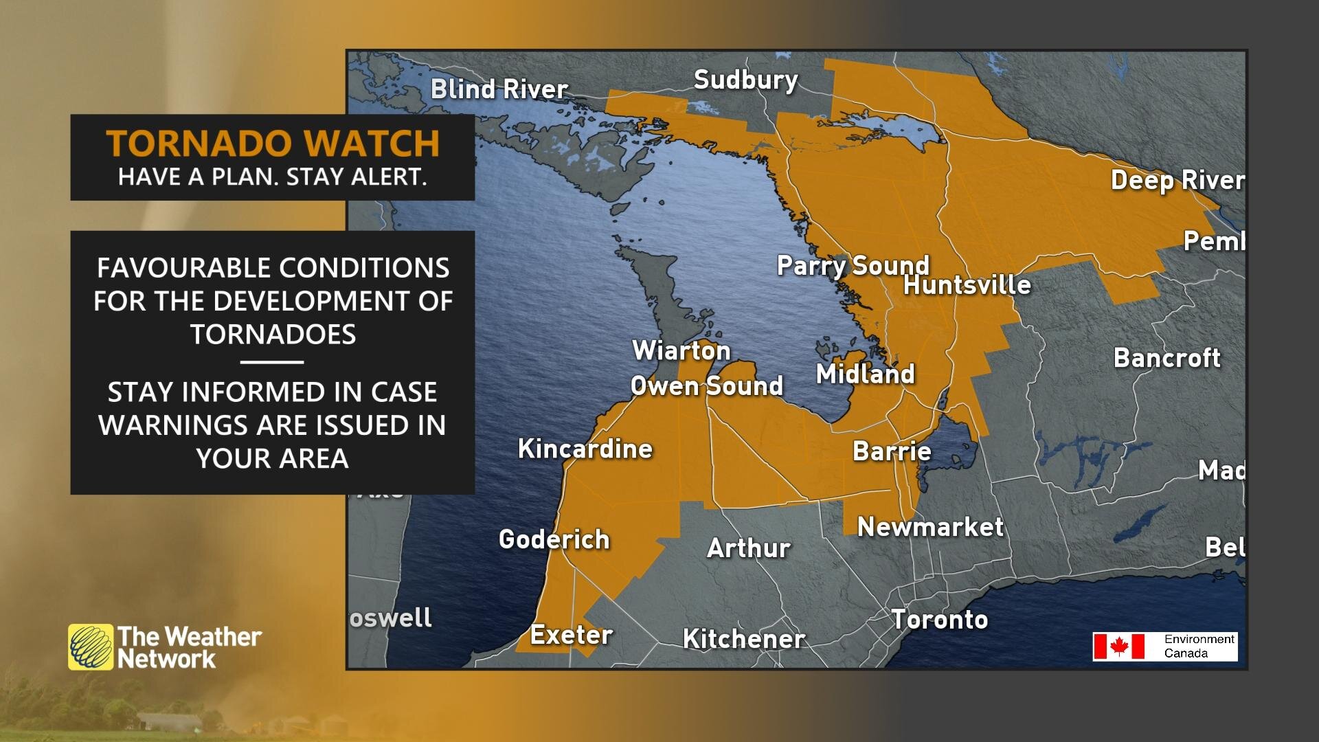
EC dropping the big one with a tornado watch locally quite early: Tornado Watch Issued at 12:03 Tuesday 14 September 2021 Summary Conditions are favourable for the development of severe thunderstorms which may produce tornadoes. Hazards: Tornadoes Large hail up to ping pong ball size Wind gusts up to 120 km/h Heavy downpours Timing: This afternoon and evening. Discussion: A line of severe thunderstorms is expected to move eastward across the regions this afternoon and into the evening. Some of these storms will likely contain tornadoes. I think they got spooked from last Tuesday with the largest tornado in Ontario history occurring near Kingsbridge-Lucknow (1300 meters wide). For comparison the violent tornadoes of May 31 1985 here were 200 and 600 meters respectively!! This tornado watch is the largest geographically I've seen too:

-
Uh I'm right here . Thrilled about my 7-day forecast, lots of warmth and humidity coming with storm chances once again on Tues . Days even reaching 72F with cold mornings are pissing me off already so just 2 days of that to go then its out.
-
Most incredible bow echo I've seen ripping through extreme SON currently: I also had my 13th storm of 2021 this morning, not forecast whatsoever. The last 7 days have been nothing short of wild here, total reversal from the last 5 years of BS!!
-
Here it comes, this could be fun. I'm always on high alert during Sep storms. I'm up to 29C already. Full sun all day so far to destabilize the most for a storm in years .
-
It was a crazy day yesterday for a variety of reasons, including the most widespread storm coverage I've seen in my province in a very long time. Yet again like the 11th the bulk of the rain was to my south so I only got some sprinkles out of a huge MCS coming through that extended down to Indiana which I can't believe. It kinked in such a way I got frequent lightning for over 90 minutes straight to my south and that makes it the 10th storm of 2021 and the first time in eons that I've had two days in a row of evening storms nearly at the same time; like the good old days. The skies looked incredible just as the potent lightning was ramping up . It seemed like every sq mile of ON got storms on Sun as the coverage was complete. There were tor warnings up in central ON as well. This was the last day of the bulk of the epic heat and humidity, I got to 33ºC yet again which I probably haven't experienced on the 29th of Aug before with a humidex over 40C. Sitting in the shade late in the afternoon was even too much after 20 mins. I'm not surprised how many cells re-ignited due to the CAPE levels.
-
I'm already down to 20ºC, not even close to the highest minimum of 23C. Its exceptionally difficult to get an overnight low that high here.
-
I'm receiving my 9th storm of the year from this avg MCS, 3 years ago today I got my 1st storm that year . Obviously this season is a dramatic improvement in the t-storm department compared to the last 3-4 years. EC couldn't help it, they issued a svr t-storm warning for what is definitely not one. 90 km/h winds possible and I got 11 km/h max during the storm . Reached 33ºC for a high which is in the top 8 temps of 2021 and the warmest minimum is forecast at 22-23ºC overnight.
-
Hurricane Ida Forecasting Contest
Torchageddon replied to WxWatcher007's topic in Tropical Headquarters
Maximum Sustained Wind Overall (mph): 140Maximum Sustained Wind at Landfall (mph): 120Pressure at Landfall (mb): 948 mbLandfall Location: SSE of Amelia (Directly south of Gibson) -
Tomorrow has the potential to be the hottest day of the year, just after Saturday's highest. TWN giving me a 33ºC feeling like 43C (highest humidex forecast in 2021). This is just a wicked heatwave for SON. My 7-day was dramatically increased for temps and humidex removing the temp cooldown on Thurs/Fri. I'll have to comb through my data but this streak of above 27-28C with the sultry is becoming insane. 2nd half of Aug 2016 didn't have sweat equity like this that I know of.
-
The nearly stationary pop up storms are mainly migrating NW which is an exceptionally rare vector around here. Constant thunder at 5pm. Early in the afternoon I was getting 33ºC for a hour or so. For 10 mins I got to 34.3ºC which may have been the hottest temp of 2021 so far . Its rare to get my yearly high this late in the summer. This is a low-key brutal heatwave (not technically a heatwave though) that is ongoing if the forecast holds 8-9 days with humidex readings 35-40C all those days . This is the hottest stretch for this specific range that I've experienced with near 30C all these days that I recall but 2016 was also similar.
-
Last week and now this week has been amazing, I've been feeling better since the heat has ramped up. I've had t-storm chances everyday since Weds and the upcoming days will be the most muggy of the summer with storms . I may have reached 32ºC already, morning air was superb.
-
As expected, the chance of t-storms was removed for today and this morning they did the 1 hour slot t-shower risk jig for 4pm which always puzzles me because we all know that's not even a 2% risk; they removed that by 1 . One bad forecast after another. Tomorrow looks similar to the last few days just with higher winds.
-
My forecast today was afternoon chance of t-storms for 5 hours with some scattered shower potential and instead there is absolutely nothing precip wise anywhere in the Great Lakes or CU formation . That's one of the biggest busts I've seen this summer as typically there would be at least a few pop ups somewhere in the province with %s that high. Other than a cap, did the smoke cause an unforeseen effect? I still have a chance of a t-storm at 10pm only listed for whatever reason. Tomorrow has a repeat forecast so I'm hoping for the same outcome.
-
The rain I had early this morning cleared out far faster than predicted, I'm getting sunny breaks as of 9am and it looks like another day has been salvaged! Its been a good week for this.