Torchageddon
-
Posts
1,409 -
Joined
-
Last visited
Content Type
Profiles
Blogs
Forums
American Weather
Media Demo
Store
Gallery
Everything posted by Torchageddon
-
Perfect summer solstice day, I'm at 30C with DP of 20C! Blues skies. If only every day of the year was like this.
-

The 2022 Summer Solstice-ish Scorcher(s)
Torchageddon replied to Hoosier's topic in Lakes/Ohio Valley
TWN is forecasting the hottest temp IMBY in years of 34C/93F with a humidex of 42/108! On Wednesday when they set my high to 31C I actually got to 35C; I'm hoping I get to the 100F mark somehow later tomorrow. After that amazing low on Sat morning of 5C/41F I'm looking forward to this. -
I got an incredible low temp of 24C/75F overnight which I reckon is a once in 3 year occurrence here. It even bumped back up to 25 for a hour or so after 4am. Lackluster showers were moving close by or just missing me resulting in no rain, sweet.
-
Summer 2022 Medium/Long Range Discussion
Torchageddon replied to Chicago Storm's topic in Lakes/Ohio Valley
Great stuff!! -
It was a lovely day where I may have had one of the hottest temperatures in several years, 35C . It stayed above 34C for 3 hours. My station reported a HI of 45C or 113. Torrid, oppressive, sauna like. Aside from the morning I also didn't have those stupid clouds ruining the day, I could see the wind shift clearly on satellite. TWN isn't in agreement with my temp but shows Windsor ON reaching a humidex of 46. TWN also showed rain starting at 6:30 pm when there was nothing for 100s of miles, then changed it to 7:30 pm, same . Now its gone as even the clouds all over my region are fading, precip start/stop feature - useful tool!
-
I'm getting extreme conditions currently, 33C/26C/41C / 92F/79F/106
-
Woke up to overcast skies and found this. The whole of the bruce peninsula was cloaked in storms which is neat. Area under a STW: 6:08 AM EDT Wednesday 15 June 2022Severe thunderstorm watch in effect for: Bruce Peninsula - Sauble Beach - Tobermory Owen Sound - Blue Mountains - Northern Grey County Saugeen Shores - Kincardine - Southern Bruce County Conditions are favourable for the development of severe thunderstorms that may be capable of producing strong wind gusts, large hail and heavy rain. Hazards: Nickel sized hail. Locally heavy downpours. Timing: This morning. Discussion: A line of strong thunderstorms has developed near Bruce Peninsula and is expected to move south this morning. Large hail and locally heavy downpours are the main threats. Overnight low was 18C, nothing special. Mostly 20C+.
-
Spring/Summer 2022 Complaint/Banter Hangout
Torchageddon replied to IWXwx's topic in Lakes/Ohio Valley
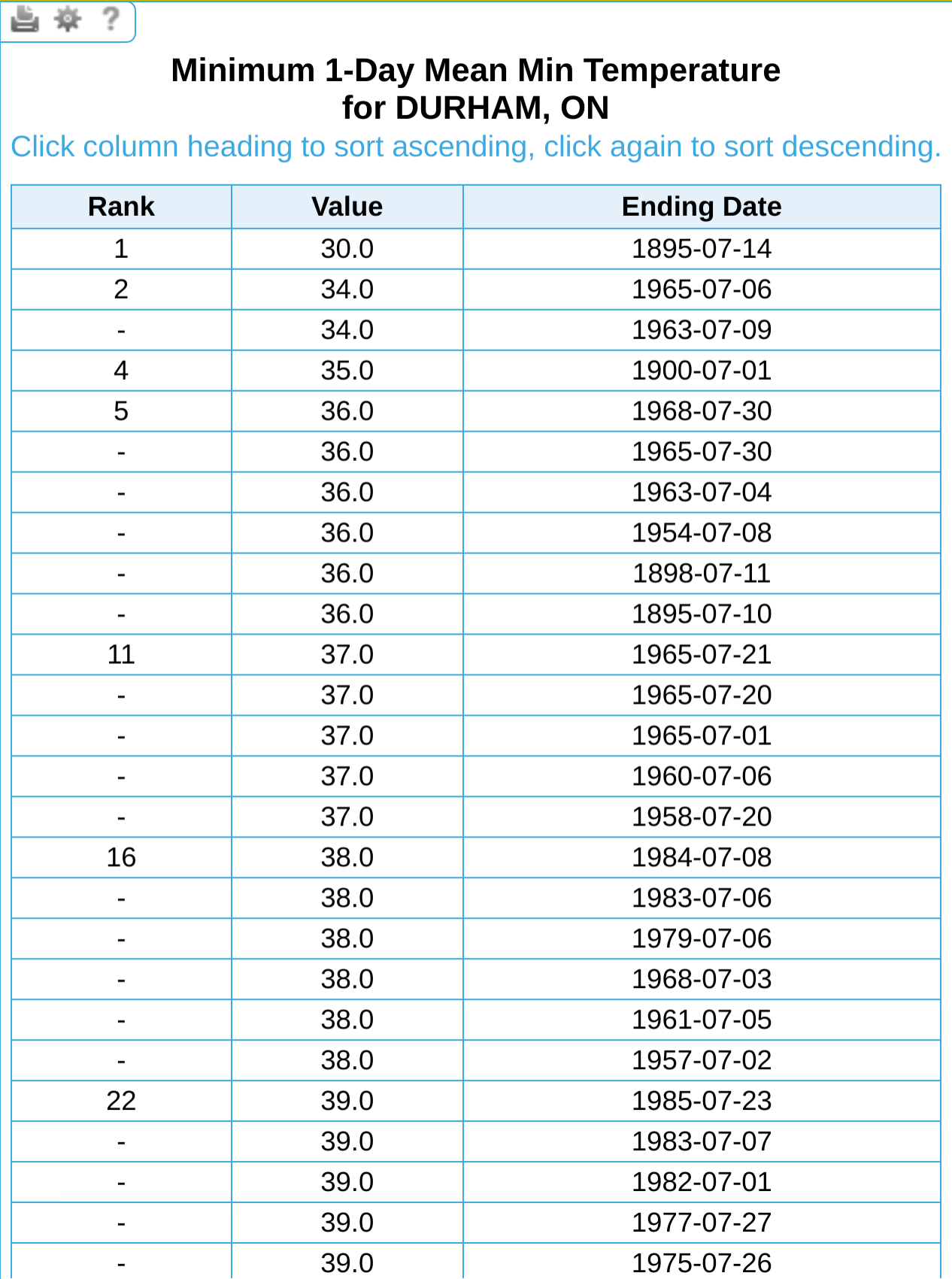
Ohio is further south but those minimums don't seem so crazy to me, what makes me think the 30F is an error is that the next record low for July is 34F tied and were both in the 1960s. If 30F was reached on July 14 1895 then something extraordinary in the records would be present like the airmass or something that could bottom out temps. The frosts were light in OH so above 32F we can surmise. -
I was just going to respond the same, yay more acronyms! Never seen NBM either - Numerical Based Models? I'm up to 29C/84F with a peak a bit higher briefly. Looked stuck around noon so I'm pleased it broke past 27C.
-
Jume is my new fav month. I like the sound of that. After the clouds rolled back in mid-afternoon yesterday like they seem to around here, its nice to see my forecast bust hard for this morning. Blue skies instead of light rain and more of the grey effluence. I thought this was possible due to the encouraging trends on radar late last night. May that bump my highs up, I'm sick of feeling cold in Jume.
-
The Van Wert storm is a unit!
-
Loop is amazing.
-
Currently 16C/61F here, mainly overcast. Disgusting and this **** has happened multiple times this June. Got another 17 mm of rain overnight. Not June so far but the last 31 days I've received a staggering 131 mm of rain (5.16 inches), half of that in the last 9 days.
-
Spring/Summer 2022 Complaint/Banter Hangout
Torchageddon replied to IWXwx's topic in Lakes/Ohio Valley
I was using that awesome site Hoosier gave me to look at extremes like mins and maxs in ON and I think I caught an error since there is no way Durham made it below 0 on July 14, even if it was 1895: I checked another station as close as possible (too bad many don't have 1895 records) to collaborate, and despite being further inland which should help diurnal cooldowns, it wasn't even close to 0 but more like 39F or 4C at Alton's station.
-
2022 Short/Medium Range Severe Weather Discussion
Torchageddon replied to Chicago Storm's topic in Lakes/Ohio Valley
Of course the first photogenic tornado from Ohio in many years is only 12 seconds long, makes sense. -
I'm curious what causes that sharply negative blob near Dallas amid surrounding positive anoms.
-
Spring/Summer 2022 Complaint/Banter Hangout
Torchageddon replied to IWXwx's topic in Lakes/Ohio Valley
@cyclone77 I was browsing the June 2012 thread and some image you posted somehow transformed into the Ukraine flag with the words "no war" printed: I guess the original file was edited from that image storage service but I didn't even know you could do that and retain the link without breakage. -
Hottest Weather So Far Lies Ahead for Phoenix
Torchageddon replied to donsutherland1's topic in Central/Western States
The good stuff. Those tables above with the stats looks vintage, nostalgia vibes. Didn't know 2020 had 53 days over 110F, would've been a good summer for me to reside there. -
How does one get the top 10 largest rainfall totals by day for cities like Chicago, Detroit, Buffalo, etc. using a current database? Checked https://www.weather.gov/wrh/Climate?wfo=dtx which doesn't have anything of the sort.
-
Spring/Summer 2022 Complaint/Banter Hangout
Torchageddon replied to IWXwx's topic in Lakes/Ohio Valley
Thanks I'll check it out. The Adirondacks Derecho would've grazed me but I wouldn't be old enough to remember it. -
Not that I believe the hourlies from TWN, but even along the shoreline winds were forecast to be elevated overnight with the temp reaching nearly as low as me. Gusts have calmed down.
-
I had an enormous diurnal temp swing that surpassed the previous largest, low of 5.5C and a high of 27C. Funny you mention the lack of clouds, it was almost 100% blue skies except a ghost or two of a wisp which is something I honestly can't recall before in a very dry day like this. Usually its either nothing at all or some fluffs. It was great out there. Overall it was a strange day since it got very breezy as the afternoon wore on and now its just plain windy as fall is, I'm getting gusts of 40 mph by estimate. Not many were outside by early evening. Going back down to 5C overnight with winds high?
-
Spring/Summer 2022 Complaint/Banter Hangout
Torchageddon replied to IWXwx's topic in Lakes/Ohio Valley
The wiki article on the Ontario Derecho had something I disagreed with and has since been removed. The cited source doesn't have anything about this within: "In Southwestern Ontario, a derecho can be expected about once every two years (once a year for Windsor-Essex), usually developing in the U.S. [[Midwest]]. The [[Kitchener-Waterloo]] and [[greater Toronto]] region experience derechos about once in every four years. Derechos in Ottawa, Montreal, and Quebec City are considerably rarer, but are not unheard of." It was removed a few days ago since the link below never had anything about Canada in it. I wasn't even sure if there was ever a documented derecho in SON, writing that K-W and Toronto get one every 4 years is ludicrous . For Ottawa, Montreal and QC - I'd have to disagree and say they are unheard of . https://web.archive.org/web/20141222110142/http://www.erh.noaa.gov/rah/newsletter/RAHNewsletter_Mar13.pdf If the author comes across this I'd like to hear their side of the story, and if there is evidence of a derecho hitting SON before May 2022. -
Spring/Summer 2022 Complaint/Banter Hangout
Torchageddon replied to IWXwx's topic in Lakes/Ohio Valley
In the early 2000s you couldn't pull up SSTs? That would be benumbling. That gives rise to this question, what was the earliest one could access satellite images online? I've seen floater images of TCs from 2002 but no earlier. -
Looked like a crap day but was waiting for the supposed clearing, found that blue skies rapidly came and an insane increase in my temps that even exceeded those isolated warm days during mid-morning recently. Just in 40 mins I went from 14.8C to 19.5C!! My station showed a 1.7ºC jump from 3:05 pm to 3:10 pm - largest I've ever seen. If I'd known that was coming I would've stood outside and pretended I was in Rapid City. I also had an extreme temp overnight yesterday where I was at 23C at 3:20 am (low of 21C), get those 4 times each summer, and this morning's low was 6C which I didn't appreciate. Had to dress like it was early-Spring.