MIstorm97
-
Posts
363 -
Joined
-
Last visited
Content Type
Profiles
Blogs
Forums
American Weather
Media Demo
Store
Gallery
Everything posted by MIstorm97
-
February 4th-7th Winter Storm Potential
MIstorm97 replied to Thundersnow12's topic in Lakes/Ohio Valley
Ride the GFS since it’s showing a rainer. -
Winter 2019-20 Medium/Long Range Discussion
MIstorm97 replied to Hoosier's topic in Lakes/Ohio Valley
GFS has been nailing the rainers and slopstorms. Ride it obviously. -
Yeah I forgot about the other private sector work. Still, with the amount of data they’re providing, it can’t be cheap. Maybe they go with a subscription for certain products at some point.
-
Yeah with all they’ve added, and still plan on adding, decent chance there will be some subscription at some point. I’ll happily pay for one though with all the products provided. Add Euro kuchera products and I’ll gladly cancel my wxbell subscription
-
They do have a Patreon where you can pledge different amounts. They want about $5k/month and are only getting around $400/month so far. Definitely would consider donating to help keep the site from having a paywall. I know they don't want to do a subscription-based service if they don't have to.
-
Not only have they added the UKMET, but it also has clickable forecast soundings for the UKMET. Pivotal is the GOAT.
-
January 22nd-25th Winter Storm Potential
MIstorm97 replied to Thundersnow12's topic in Lakes/Ohio Valley
Was some nice video of white rain. Stacking droplets. -
January 22nd-25th Winter Storm Potential
MIstorm97 replied to Thundersnow12's topic in Lakes/Ohio Valley
Fluctuating between 1/16SM and 1/4SM in Royal Oak. Better than nothing I guess? This storm has been trash. -
January 22nd-25th Winter Storm Potential
MIstorm97 replied to Thundersnow12's topic in Lakes/Ohio Valley
35F and rain the entire drive down 127. Below bottom shelf weather. -
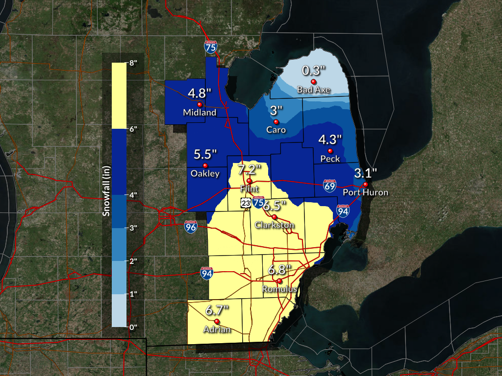
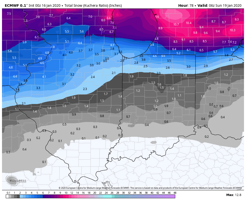
DTX has already put out a storm total map. I finished with 6.4” in the mid morning. Hope to get some squalls tonight that drop a little more.

-
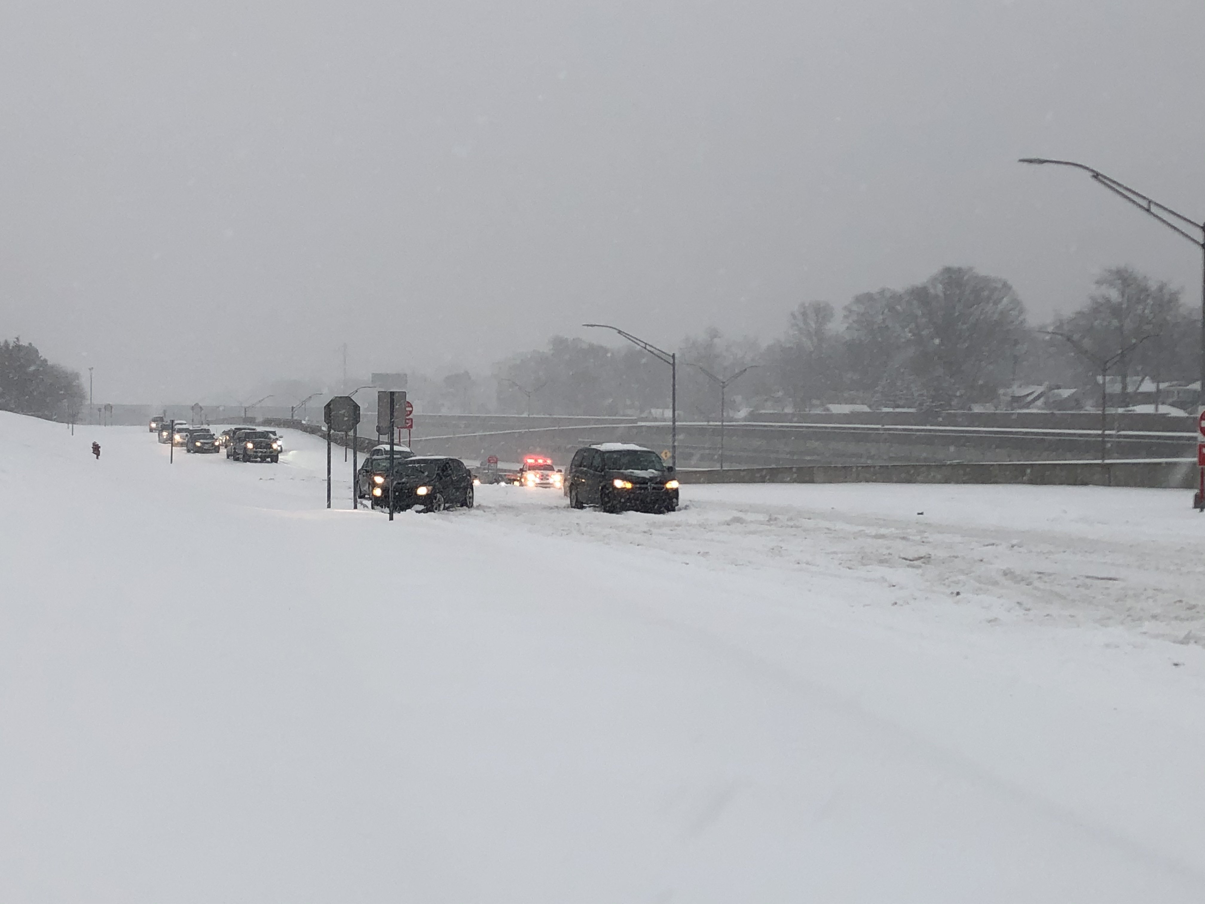
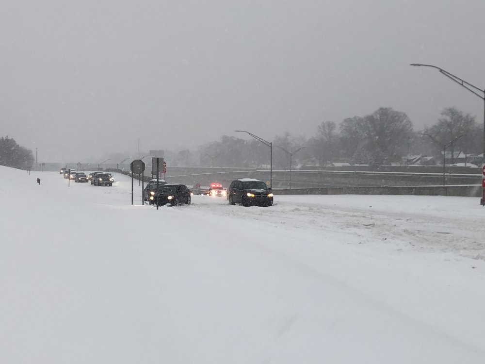
Man the roads are bad. Barely a county or state plow in sight. The exit ramp to Woodward from 696 had many stuck cars.
-
It’s been rip city out in the first band. Fair amount of blowing snow too

-
Flakes have started in Berkley. Ready for that first weenie band to roll in. HRRR has slowly ticked amounts up a little and delayed the onset of the wintry mix. All systems are a go.
-
Locked n’ loaded in SEMI on the 00z NAM. Plumes ticked up a bit too at DTW and Selfridge. Could be a respectable little storm here.
-
Taking this to the bank right now
-
DTX issued a Winter Storm Watch for its entire CWA. Heavy snow with accums of 4-7”. Certainly will take it.
-
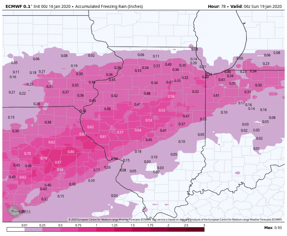
Ice map cometh (along with snow)

-
Picked up 0.7” a couple nights ago and another 0.5” now. Penny’ing our way to something this month.
-
DTW hit at least 58F so far, so that beats the record of 57F from 2016. Been one balmy week for sure. Did Christmas shopping in shorts and spent most of Christmas outdoors with the family. Much rather have the snow, but after being in a bad car crash caused by a drunk driver, I’m fine with not shoveling for a bit.
-
Been some notable tornado/severe events in the region this decade: June 5-6th, 2010: regional outbreak with a nighttime EF4 very close to Toledo. Octobomb 2010: High Risk in the Eastern Lakes, lots of QLCS tornadoes. April 19th, 2011: Multiple strong tornadoes across IL. May 25th, 2011: High Risk in the southern part of the sub. High number of severe reports. March 2nd, 2012: High Risk in the far southern part of the sub. Major tornado outbreak. Also had the Harrisburg, IL EF4 a few days earlier. March 15th, 2012: Multiple significant tornadoes in Michigan, including Dexter EF3. Last time there was an EF3+ tornado in Michigan. June 2012 Derecho: Destructive derecho forming in IA/IL and tracking all the way to the Atlantic. June 12th, 2013: High Risk across Northern IL. November 17th, 2013: High Risk across large portions of IL and IN. Record-breaking tornado outbreak that included the Washington EF4. June 30th-July 1st, 2014: Two derechos tracked across the sub. Prolific QLCS tornado event in NW IN and NE IL. April 9th, 2015: Multiple tornadoes across the region, including the long-tracked, violent, Rochelle EF4. June 22nd, 2015: Tornado outbreak from Iowa to Michigan. Included the Coal City EF3. December 23rd, 2015: A few late season tornadoes in Illinois and Michigan. First December tornado in Michigan history. June 22nd, 2016: Near-repeat of the same setup and event one year prior. Multiple significant tornadoes across Illinois. August 24th, 2016: Surprise tornado outbreak across Indiana and Ohio. Included the Kokomo EF3 and Woodburn EF3. A large EF2 tornado went through the industrial portions of Windsor, ON too. February 28th, 2017: Significant early season tornado outbreak across the region. Included the Washburn EF3, Ottawa EF3, and Perryville EF4. March 6th, 2017: Prolific QLCS tornado event in the western portions of the sub. December 1st, 2018: Record-breaking wintertime tornado outbreak across Illinois. Included the Taylorville EF3. May 27th, 2019: Tornado outbreak from Illinois to Ohio. Predicted to be the worst in Illinois, but ended up more in IN and OH. Included the Dayton EF4. Pretty expansive list, but I’m sure I’m missing some events. Ended up chasing most of the events in the region from 2015 onwards, and a lot of other events that aren’t on here.
-
Winter 2019-20 Medium/Long Range Discussion
MIstorm97 replied to Hoosier's topic in Lakes/Ohio Valley
Detroit needs 2.4” to break its all-time snowiest November record (11.8” in 1966). Might as well go for it this weekend considering all the other November snowfall records have been broken. -
Detroit is down to 9°F and dropping, which breaks the daily record of 12°F. As mentioned earlier, it’s the earliest single digit low temperature in Detroit’s history, with the old record being 8°F on 11/16/1933. Detroit ended up breaking every daily cold temperature record for the 12th: record low, record high minimum, and record low average temp. Impressive combination of record snow followed by record cold.
-
Finished with 9.8” of snow at my house in Berkley. By far the best November storm I’ve been in. Felt much more like a mid winter storm than something out of the first half of February with the combination of good ratios, blowing snow, and cold temperatures. Made sure to come home from CMU to see this storm, and it was well worth it to see Detroit’s largest November snowstorm. Since I got over 6” with this storm, it means this winter continues the streak of at least one 6”+ snowstorm each winter since 2011-2012 imby. My season total is up to 10.9” after that little snow band last week dropped just over an inch. Wish I could’ve stuck around today to get daytime pictures, but these will do. Saw numerous slide-offs from both yesterday and today on 96 on my way back to CMU. Video: https://youtu.be/bgFX86XiytI
-
Never got a warning. Was surprised an upgrade didn’t come in the morning or early afternoon when it became apparent that there would be higher totals in the persistent FGEN banding.
-
Report just came in that DTW is at 8.5”.