

SouthCoastMA
-
Posts
6,990 -
Joined
-
Last visited
Content Type
Profiles
Blogs
Forums
American Weather
Media Demo
Store
Gallery
Everything posted by SouthCoastMA
-
All aboard the qg_omega / Great Snow of 1717 Express
-
His post wasn't wrong at the time, that's what it showed on 11/30. But why are you comparing 500mb with 2m Temp anomalies.
-
George001 has always channelled the spirit of James (Rest in Peace). Gotta love his enthusiasm. It's sorta like that movie Beerfest where Landfill's identical twin brother comes to visit and allows his friends to call him Landfill, so it's like he never left us.
-
lol - the long range OP runs definitely have an emotional sway to this board, whether or not some like to admit it. Quickly looking, there's still a lot of potential here, especially for interior and NNE. Wouldn't be shocked if we are tracking a legit winter storm (or 2) for many in the next few days, targeting that mid-month range.
-
I'd be excited if I lived in interior. TBlizz and I are probably looking at 6" of rain over the next 10-12 days. Its just too early down here without a cold airmass
-
I'm guessing the clown range GFS was already discussed, but this would be something.
-
we typically punt early/mid December anyway..so I'm fine with waiting another 10 days before hopefully getting a couple legit threats to track
-
BOS: 44" KDIT: 43" KPVD: 30" KORH: 57" KMETH: 54" KMBY: 35" KTBLIZZ: 45" KDRYSLOT: 60" KWEY: 48" There were will be one big storm that will jackot EMA, specifically NE Mass, maybe tickle Weymouth, and hammer Dryslot. Some CJ action along the coast. Otherwise, average year at best.
-
Everything sucks. I mainly blame the coaching for destroying any progress he might have made in year 2, though. I think he could've been a serviceable QB if under the proper coaching (think Jared Goff, Alex Smith). I turned the TV off at halftime after the missed FG. It's unwatchable at this point.
-
he hitched to the pope wagon. the one where pattern changes don't exist, even though we just had one.
-
My mindset was always: 12/5 is when I'll start looking for threats on models. so maybe by then the models will start picking up on trackable winter storms in the day 5+ range. If that gets pushed a couple days, then whatever
-
I think a disappointment at this time year would be a shutout through 12/20. Despite the good pattern ahead, I would take 2-4" in mid December and be content.
-
We salvage Saturday morning here, for final leaf cleanup
-
I just bought some today in the low 4's. lowest since early August
-
Just need to avoid this: https://mesonet.agron.iastate.edu/current/mcview.phtml?prod=sel2rad&java=script&mode=archive&frames=200&interval=5&year=2020&month=12&day=24&hour=23&minute=55
-
Just blew through here with scattered outages. wild
-
-
Pattern is promising but who the hell really knows until we get some storms to track in the mid range. I'd be content with a few inches around mid month or just before the holidays..sans a Christmas grincher
-
live look
-
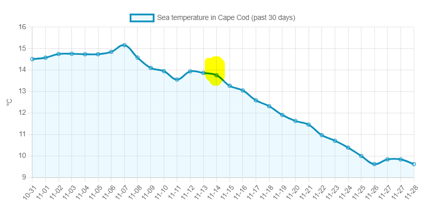
From 11/13 through today, SSTs in Cape Cod bay dropped from 57° to 49°. It's been a steady drop since the 'pattern change that never happenend'
-
so models in the long range were off about 2 days? doesn't seem like something to get bent out of shape over
-
I've been conditioned to accept it, and it helps to know that we can still score on high end storms from time to time. Plus, other things like wind and the occasional OES keep it somewhat interesting.
-
Would you rather have them currently showing a death vortex over GOA and a raging +NAO. No reason to panic yet on 11/22
-
Oh yeah..I'm just ribbing him - I was a big fan of the December 2020 period prior to the epic grincher. Like you said, the panic this early is absurd - especially with ensembles looking pretty good attm.
-
Kevin only wants snow in December so he can be like a kid in his jammies around the holidays, sipping hot chocolate, and looking out the window at the snow. He has a lot invested in December panning out, hence the lashing out.


