

TugHillMatt
-
Posts
10,356 -
Joined
-
Last visited
Content Type
Profiles
Blogs
Forums
American Weather
Media Demo
Store
Gallery
Posts posted by TugHillMatt
-
-
23 minutes ago, DeltaT13 said:
I'm stressed out man! I would have rather just had a boring ass weekend with no weather to worry about as this is the last real trip of the year.
The people of Vermont beckon you.
-
 3
3
-
-
Oh, look! Another synoptic wave that gifts Syracuse the shaft. We suck.

-
1
-
-
Hm. One model has a low over Western NY, while a different one has it off the VA coast.
An increase in technology sure has made things easier for humans..................................................
-
Is it going to keep shifting further east and get weaker? Is this a time where we can actually get an east shift and then have it move back west as we get within 48 hours? Or do we get screwed to the east this time?
-
Lol..it's like the models are programmed to show less in Northern Onondaga and Southern Oswego counties. Oneida Lake Effect?
-
6 minutes ago, LakeEffectKing said:
One piece of energy is coming from the Arctic, the other piece is coming from the Bering sea area.

Ok, I think we get it.
")
-
3
-
-
16 minutes ago, wolfie09 said:
Icon 12z

It has actually done better this year than in years past. I also see some of that heavy precip it's showing in the form of rain before the changeover to be heavy mixed precip. or heavy snow from dynamic cooling.
-
22 minutes ago, Bubbler86 said:
It literally has the whole system farther north. How much for Albany? @TugHillMatt is watching closely.
Ha. Some of the mesos have us getting several inches of snow, while the HRRR has the precip. too light and raining here. I absolutely HATE living at a lower elevation.
-
 1
1
-
-
2 minutes ago, wolfie09 said:
On Wednesday, southern stream sourced shortwave trough trending
toward impacting eastern forecast area with light
precipitation, mainly in the form of snow. PVA from the
shortwave with divergence aloft provides most of the forcing as
stronger low-level convergence and moisture transport is tied
into sfc low which will be shifting off the East Coast Wednesday
afternoon. Look at forecast soundings and 2m temps points to
wet-bulb cooling keeping majority of the precip as snow, though
a mix of rain/snow showers is likely on edge of stronger lift
/mid-level cooling with shortwave. Still will be sharp western
edge to this system with only chance pops BUF to ROC to SLV. In
terms of snow accumulations, could see as much as a few inches
from NY/PA line to Finger Lakes and over higher terrain east of
Lake Ontario. Given marginal temps in the lower 30s, most of the
snow will be at highest elevations
We'll see. Some mesos have increased the totals, while others have cut back. Per usual, guess who's on the edge of the line...and a cliff?

")
-
1
-
-
10 minutes ago, rochesterdave said:
6z GFS was much less impressed. Later phase. Stringy mess. It finally gets its act together but too far ne. A possibility. The ICON was a massive bomb.
Yeah, I saw that late development. Definitely a possibility. Hopefully not. We've had bad luck with timing of systems developing too quickly or too slowly.
-
17 minutes ago, wolfie09 said:
Will need to continue to
monitor the trends as this system could produce several inches of
accumulating snow and also gusty west-northwest winds on Saturday as
the deepening system lifts across New England and very chilly air
for this time of year pours across the lower Great Lakes region.
This would be the FIRST WNW lake enhanced event with a Low pressure here in 3 years. There's been some N and NW events...but not the WNW that provide for snow desert of the Cuse. Hopefully we can get this to happen.
-
1
-
-
48 minutes ago, Thinksnow18 said:
I hear a whole field of crickets ATM…
I'm busy looking out the window trying to find the 2 to 3 inches of failed lake effect snow I was supposed to get....
NW wind...yet again.....Lake enhanced snow and Triple lake connection on a WNW flow seem to be the only thing lakes provide here.
-
2
-
-
Yes, Dave. I saw the stupid HRRR. There's always one model that shows us getting the shaft. All the other ones don't show this. Can the one warm model be WRONG for once?
-
Wednesday's turning out to maybe be a sneaky event. 0Z Nam actually has a few inches of snow for CNY and an inch or 2 for Western NY on Wednesday. 3K and mesos have it too. Long Island and my family down in PA could get a warning event. I just hope this doesn't cause the late week event to shift NW.

-
13 minutes ago, rochesterdave said:
This feels like it’s 10 days off. It’s not. Precip could start in as little as 100 hours. I think this is a pretty high confidence event. Precip types and exact track are probably up in the air for another 48 hours. But this should be an easier forecast than we’ve had. More like the early Feb storm than the stupid sliders we’ve had.
There you go. That's what I was talking about earlier. As you can tell, I am more positive about this event than most of the other ones this season. It's a different track than what we've seen.
My entire school community was on a high from the record warm day yesterday. I ruined it when I kept sharing that snow was possible several times this week. Muwahahahaha.....everyone here knows me as the "crazy guy who loves snow."
-
The heavier rates still lead to a similar outcome, with a slightly more west-based bias:


-
1
-
-
Elmwood Cam looks to show decent snowfall coming down in Buffalo right now.
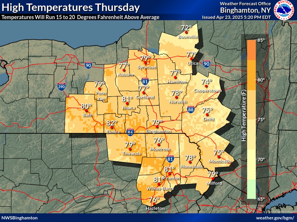
Quite the front across New York state today! Dansville went from 30s in the early afternoon to 60s a few hours later, and now down to 46 with rain. Surprisingly, here in Syracuse we've stayed in the Upper 30s all day. Looks like the front got caught up in the higher elevations in the southern end of Onondaga county, as it's 40 here right now and in the mid 50s down in the Tully area on the southern end of the county. Sometimes that north wind can trap the cold air here in the Lake Plain.
-
Totals were increased for tonight and tomorrow. With the warm weekend and wet conditions from today, it'll definitely be a Spring-like snowfall with roads remaining wet. BGM has "2 to 4 inches" for Onondaga County in the zone forecast.
-
1
-
-
1 hour ago, rochesterdave said:
Slow down Matt. Don’t get your hopes too high just yet. Still lots of spread and a decent potential that this does the same thing a lot of them have done. Syracuse and points east are on a razors edge.
Hey, like I've said, I call them as I see them.
I mentioned yesterday that our best shot of a Noreaster was this upcoming weekend. The way the jetstream is setting up with that cold push of air cutting south makes this one of our best shots of the season. It's not so much relying on a high pressure to our north to squeeze in enough cold air while a system stalls over us. The models are showing this Noreaster look more today, with a very widespread snowfall. It's not as much of a narrow band. If it comes to fruition, that would be awesome. (I do understand your cautioning me though. )
-
1
-
-
Could be our most widespread snowstorm of the season.
-
4
-
-
I'm shocked there's still some snow cover here on the north facing hills. We actually still had a pretty solid snowpack until yesterday morning...then the 70s took most of it away. But some still hanging in there for dear life.
-
2
-
-
57 minutes ago, vortmax said:
Something that strong will have lots of dynamic cooling. Really hoping we get a bonifide blizzard - Spring could come any time after that...lol
I almost "liked" this until your last sentence.
-
1
-
1
-
-
15 minutes ago, wolfie09 said:
Poor Matt, can never catch a break
.gif.7f41ebf953b00b6f7e3e82d08444607e.gif)
LOL! I can't.... nope....not saying anything else. lol
-
2
-
-
This morning's GFS (The models can't decide if we're going to have Winter or Spring):


Potential large EC storm/Heavy LES March 11-13th
in Upstate New York/Pennsylvania
Posted
Thanks. Much better than 12Z and gives leeway for more shifts.