TugHillMatt
-
Posts
10,356 -
Joined
-
Last visited
Content Type
Profiles
Blogs
Forums
American Weather
Media Demo
Store
Gallery
Everything posted by TugHillMatt
-
Upstate/Eastern New York-Into Winter!
TugHillMatt replied to BuffaloWeather's topic in Upstate New York/Pennsylvania
I'm telling you...our base state weather in winter now is maritime air, a couple hours of lake effect behind a cold front...rinse, repeat. We get like a few weeks to month of some winter, but that's about it. I fully expect our weather to continue like this into December. Pacific Jet ruling the day. -
Upstate/Eastern New York-Into Winter!
TugHillMatt replied to BuffaloWeather's topic in Upstate New York/Pennsylvania
Another one... it's PulaskEYE.... lol -
Upstate/Eastern New York-Into Winter!
TugHillMatt replied to BuffaloWeather's topic in Upstate New York/Pennsylvania
Getting some nice snow showers here that are frosting the ground. But can't get any more of a covering than that here in the maritimes of Upstate. -
Upstate/Eastern New York-Into Winter!
TugHillMatt replied to BuffaloWeather's topic in Upstate New York/Pennsylvania
Ha! "Low" is actually pronounced with on "o" sound that rhymes with "how." -
Upstate/Eastern New York-Into Winter!
TugHillMatt replied to BuffaloWeather's topic in Upstate New York/Pennsylvania
Your last paragraph is what I was referring to. -
Upstate/Eastern New York-Into Winter!
TugHillMatt replied to BuffaloWeather's topic in Upstate New York/Pennsylvania
Band is finally nudging south. Hopefully it doesn't fly through at 90 mph.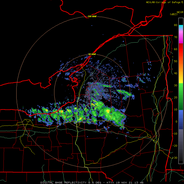
-
Upstate/Eastern New York-Into Winter!
TugHillMatt replied to BuffaloWeather's topic in Upstate New York/Pennsylvania
Meh. Some big flakes and a light dusting on cars and rooftops. Per usual, too mild and the band keeps bending around my area... seriously, I am a snow jinx. -
Upstate/Eastern New York-Into Winter!
TugHillMatt replied to BuffaloWeather's topic in Upstate New York/Pennsylvania
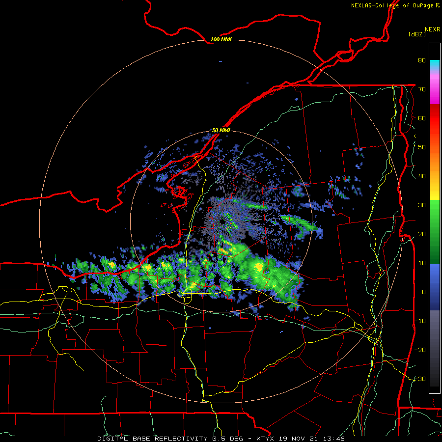
BGM updated their HWO for 1 to 3 inches for the Syracuse region (higher elev. getting the most). Hopefully the band gets here sooner in the morning when the sun plays less of a factor. Onondaga-Madison-Southern Oneida- 1054 PM EST Thu Nov 18 2021 This Hazardous Weather Outlook is for central New York. .DAY ONE...Tonight and Friday. A lake effect snow band will drop south through the area mid morning Friday into the early afternoon hours. This lake effect band could produce a quick 1 to 3 inches of snow, especially for the Mohawk Valley region and other surrounding higher elevations. Be prepared for the early season winter weather, especially if you are planning to be on the roads during this timeframe. -
Upstate/Eastern New York-Into Winter!
TugHillMatt replied to BuffaloWeather's topic in Upstate New York/Pennsylvania
While still having its big flaws, I would say this map is "best" at showing areas that get the heaviest and least lake effect snowfalls in general. It shows the general primary belts based on wind direction, and the secondary belts that still get decent snowfall on a WNW flow, etc. I would still move the Tug maxima a bit farther north, and move the "120 inch line" farther south into much of Onondaga county...based on averages and the facts that the hills to the south of Syracuse and up to Cazenovia average about that much from orographic lift and heavier synoptic snowfall. It's also too low in the northern half of Erie County...and for the Chautauqua Ridge. Many areas along the ridge average close to 200 inches. Also, the southern burbs of Buffalo definitely average more than 100 inches of snowfall. But, like I said, all the maps miss out on some key microclimates. -
Upstate/Eastern New York-Into Winter!
TugHillMatt replied to BuffaloWeather's topic in Upstate New York/Pennsylvania
Actually, that map is a pretty poor map. Way too low on snow for the Northern Tug and Syracuse area. Too high for the Finger Lakes area around Dansville. I made the mistake of trusting that map when I lived in SOUTH Redfield for a winter. The snow maxima over the Tug is actually farther north and west than what you see here. The area where Jefferson, Oswego, and Lewis counties meet is the snowiest area. -
Upstate/Eastern New York-Into Winter!
TugHillMatt replied to BuffaloWeather's topic in Upstate New York/Pennsylvania
Don't expect much. Our areas might get an inch, if that. The air is just too mild in the lower elevations. In Oswego, you'll often see the bands jump over the immediate Lakeshore. The area around Fulton to Mexico could see a couple inches. It's common for that area to "max out" compared to surrounding locales. -
Upstate/Eastern New York-Into Winter!
TugHillMatt replied to BuffaloWeather's topic in Upstate New York/Pennsylvania
Yeah, I checked the webcam of Jines Restaurant and Park Ave. and it was definitely snowing there for hours...very wet stuff. -
Upstate/Eastern New York-Into Winter!
TugHillMatt replied to BuffaloWeather's topic in Upstate New York/Pennsylvania
I thought Rochester changed over during the synoptic event early in the week? -
Upstate/Eastern New York-Into Winter!
TugHillMatt replied to BuffaloWeather's topic in Upstate New York/Pennsylvania
I see that coming for tomorrow night into Friday as well. Looks like it hits the Tug, quickly jumps over us as winds turn NW and it hits the Auburn area. Looks very similar to this past Tuesday's conditions. Maybe a repeat on next Monday night and Tuesday? #2 and 3 of 3431432 dustings? Not sure where we're heading once we get to December. Seems like many question marks in the air. That Pacific Jet....ugh. But, perhaps a -NAO to fend it off. But, there are a couple runs of ugliness (for us) setting up over Alaska. We shall see... -
Upstate/Eastern New York-Into Winter!
TugHillMatt replied to BuffaloWeather's topic in Upstate New York/Pennsylvania
Oh, shut up. You made sure I was sitting on the 0 line, didn't you??? -
Upstate/Eastern New York-Into Winter!
TugHillMatt replied to BuffaloWeather's topic in Upstate New York/Pennsylvania
It's currently warmer in many areas of Upstate New York than Atlanta, Nashville, Charleston, Savannah, Tallahassee, Jacksonville, Dallas, and Phoenix suburbs. Chinook winds of the east. -
Upstate/Eastern New York-Into Winter!
TugHillMatt replied to BuffaloWeather's topic in Upstate New York/Pennsylvania
With as often as he posts video, pics, and obs of snow in Hamburg, I feel like he should average 200 inches. Or, maybe it's just he's had closer-to-actual-normal winters than the Sizzle. -
Upstate/Eastern New York-Into Winter!
TugHillMatt replied to BuffaloWeather's topic in Upstate New York/Pennsylvania
I think it's too soon to say it's more wintry than normal. Temps so far are a bit above normal. As we get closer to forecasted "cool air" it modifies. Any time we think we're done with warm air, we get surprise days back in the upper 50s and 60s. The average high for today is 48 and here we are easily and casually making it to the upper 50s in what was supposed to be "cooler." If what is forecasted happens, then we may end up right around normal. I said about a month ago I was skeptical of getting a cold November because everything runs WARM these days. I hope we continue the step down next week into a colder regime with better snow chances. But, as we get closer, here we go again....mild, maritime air with cool, maritime air behind the system that doesn't cut it for those not in higher elevations. We say it's abnormal for it to snow in November in the lower elevations, which is not true. It's "supposed" to snow in Upstate NY. The higher elevations will DEFINITELY do better at this time of year. But, I wouldn't say it's "wintrier than normal." Syracuse should have several inches by now, and averages about 10 inches for the month. If we can get some lake effect events, we might get there. But, the synoptic pattern has just been meh during winters of late. As several have mentioned, it's like the "base" pattern that we fall back into is stale, mild air with cold that somehow has to be manufactured. I hope it's just November being November...and that we don't see this as the pattern in the winter months to come. -
Upstate/Eastern New York-Into Winter!
TugHillMatt replied to BuffaloWeather's topic in Upstate New York/Pennsylvania
Ouch. That has a +AO look. Hopefully just a blip. -
Upstate/Eastern New York-Into Winter!
TugHillMatt replied to BuffaloWeather's topic in Upstate New York/Pennsylvania
Eh, I don't know. It was a nice, chilly day here...and then the southerly winds that I flipping hate kicked in and the temp continues to rise, rise, rise into the night.... 10 degrees warmer in the sizzlehellcuse compared to Rome -
Upstate/Eastern New York-Into Winter!
TugHillMatt replied to BuffaloWeather's topic in Upstate New York/Pennsylvania
Speaking of sizzle, I see you have about 12 times more snowfall than we do on the season.... -
Upstate/Eastern New York-Into Winter!
TugHillMatt replied to BuffaloWeather's topic in Upstate New York/Pennsylvania
It looks worse as we get closer? Shocking.... -
Upstate/Eastern New York-Into Winter!
TugHillMatt replied to BuffaloWeather's topic in Upstate New York/Pennsylvania
Yuck. There's like no cold air with the actual synoptic portion. I know it's only November, but that has been the theme of recent years. But this whole run is sort of an odd look anyways. -
Upstate/Eastern New York-Into Winter!
TugHillMatt replied to BuffaloWeather's topic in Upstate New York/Pennsylvania
Hilarious! All those circular arrows, dabs of white, and spilled blues and greens add to the crisis... -
Upstate NY Banter and General Discussion..
TugHillMatt replied to wolfie09's topic in Upstate New York/Pennsylvania
I think you need to hide in your house until 2021 is over. You've had way too much crap happen to you this year. Shut 'er down! Time to hide in the man cave and turn your heat up to 95 degrees...