mimillman
-
Posts
3,468 -
Joined
-
Last visited
Content Type
Profiles
Blogs
Forums
American Weather
Media Demo
Store
Gallery
Everything posted by mimillman
-
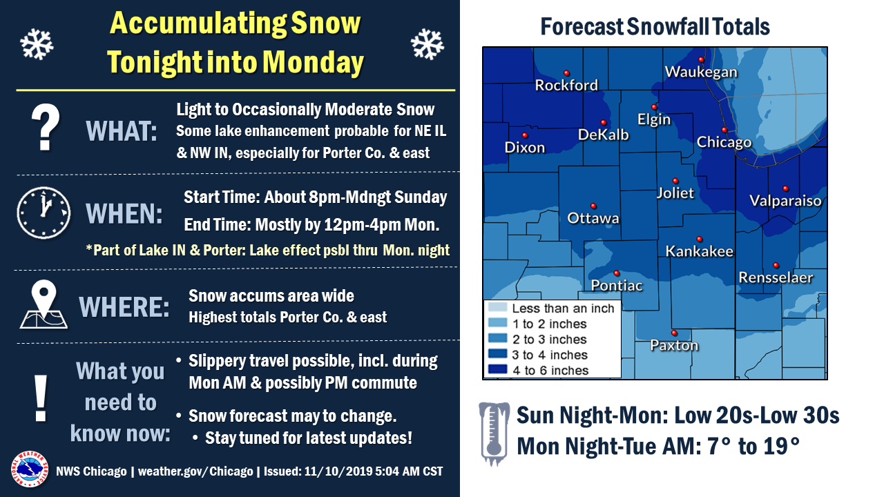
URGENT - WINTER WEATHER MESSAGE National Weather Service Chicago IL 1255 PM CST Sun Nov 10 2019 ...ACCUMULATING SNOW TONIGHT INTO MONDAY WILL RESULT IN HAZARDOUS TRAVEL CONDITIONS... ILZ005-006-012>014-022-INZ001-110300- /O.NEW.KLOT.WW.Y.0021.191111T0600Z-191111T2000Z/ McHenry-Lake IL-Kane-DuPage-Cook-Will-Lake IN- Including the cities of Crystal Lake, Algonquin, Lake in the Hills, McHenry, Woodstock, Cary, Waukegan, Buffalo Grove, North Chicago, Highland Park, Mundelein, Gurnee, Round Lake Beach, Aurora, Elgin, Naperville, Wheaton, Downers Grove, Elmhurst, Lombard, Carol Stream, Addison, Chicago, Humboldt Park, Hyde Park, Lakeview, Lincoln Park, Logan Square, Navy Pier, Joliet, Bolingbrook, Gary, Hammond, East Chicago, and Merrillville 1255 PM CST Sun Nov 10 2019 ...WINTER WEATHER ADVISORY IN EFFECT FROM MIDNIGHT TONIGHT TO 2 PM CST MONDAY... * WHAT...Snow expected. Total snow accumulations of 3 to 6 inches, with the heaviest accumulations expected over the central and northern portions of the Chicago metropolitan area where isolated higher totals area possible. * WHERE...Portions of northwest Indiana and northeast Illinois. * WHEN...From midnight tonight to 2 PM CST Monday. * IMPACTS...Untreated roads will become snow covered and travel difficult. The hazardous conditions will greatly impact the Monday morning commute. * ADDITIONAL DETAILS...Gusty north to northwest winds Monday could result in some minor blowing and drifting snow in open areas. PRECAUTIONARY/PREPAREDNESS ACTIONS... Slow down and use caution while traveling. The latest road conditions for Illinois can be obtained on the internet at www.gettingaroundillinois.com. The latest road conditions for Indiana are available by calling 1-800-261-7623. && $$
-
I think an Advisory is prudent for the entire CWA and depending on how the band looks in the AM, that’s where a warning gets triggered.
-
I think 3-6” is a lock for the entirety of Cook County. The higher amounts will be in the northwestern part of the county and some lucky spots on the lake where LES is most persistent.
-
Not bad
-
Extremely disappointing performance from the American guidance.
-
Yea I think the 18z euro is pretty much a best case scenario with this type of set up, that is, lacking any more prominent synoptic features.
-
Assuming the Euro doesn’t cave, shaping up to be US vs foreign models. Fun.
-
Ouch
-
This seems like one of the rare occasions this early in the season where the lake shore can outperform the burbs. I think the timing of the front is key for the metro area as the more precipitation we can maximize outside of peak daylight hours, the more significant accumulations can be. Temps are certainly not as marginal as the last event.
-
Here comes winter -- October 28-November 1 Snowstorm Potential
mimillman replied to Hoosier's topic in Lakes/Ohio Valley
I’d imagine we have accumulated about 2” on grassy surfaces right by the lake. Tried to load a picture but file size is too big -
Here comes winter -- October 28-November 1 Snowstorm Potential
mimillman replied to Hoosier's topic in Lakes/Ohio Valley
Has been coming down in the Loop at a good clip for the past several hours, but nothing sticking, not even to grassy surfaces. -
Here comes winter -- October 28-November 1 Snowstorm Potential
mimillman replied to Hoosier's topic in Lakes/Ohio Valley
Snow downtown -
Here comes winter -- October 28-November 1 Snowstorm Potential
mimillman replied to Hoosier's topic in Lakes/Ohio Valley
00z NAM showing changeover on the lake between 17z and 18z tomorrow -
Here comes winter -- October 28-November 1 Snowstorm Potential
mimillman replied to Hoosier's topic in Lakes/Ohio Valley
Similar situation here.