mimillman
-
Posts
3,615 -
Joined
-
Last visited
Content Type
Profiles
Blogs
Forums
American Weather
Media Demo
Store
Gallery
Everything posted by mimillman
-
Winter 2020/2021 Short Range Discussion
mimillman replied to Chicago Storm's topic in Lakes/Ohio Valley
Radar doesn’t look bad. Wouldn’t be surprised to pick up an inch -
Jan 24-26th Potential Something Part 2
mimillman replied to Chicago Storm's topic in Lakes/Ohio Valley
They can always issue a watch and replace it with an advisory, that’s the purpose of a watch vs a warning -
Jan 24-26th Potential Something Part 2
mimillman replied to Chicago Storm's topic in Lakes/Ohio Valley
The GEM continues to hang precip around the lake well into Tuesday. Clear trend for a longer duration event with a drier defo but equivalent QPF overall Edit: eh, maybe 0.1-0.2” less -
Jan 24-26th Potential Something Part 2
mimillman replied to Chicago Storm's topic in Lakes/Ohio Valley
This is the largest event of the season for the CWA and the largest event for the metro in 3 years. They will issue a watch -
Jan 24-26th Potential Something Part 2
mimillman replied to Chicago Storm's topic in Lakes/Ohio Valley
Looks reasonable -
Jan 24-26th Potential Something Part 2
mimillman replied to Chicago Storm's topic in Lakes/Ohio Valley
RGEM very pro Wednesday lake plume -
Jan 24-26th Potential Something Part 2
mimillman replied to Chicago Storm's topic in Lakes/Ohio Valley
We’ll see. I’m riding my 6-12. Have faith that even in the event of a sheared solution, the lake will help us and we’ll have our first 6” event in 3 years. Maybe. -
Jan 24-26th Potential Something Part 2
mimillman replied to Chicago Storm's topic in Lakes/Ohio Valley
Fair, but by that metric you’d have the same worry for south central Iowa, no? -
Jan 24-26th Potential Something Part 2
mimillman replied to Chicago Storm's topic in Lakes/Ohio Valley
Idk but it’s what I got -
Jan 24-26th Potential Something Part 2
mimillman replied to Chicago Storm's topic in Lakes/Ohio Valley
And a 12 hour break before a 1-2” refresher Wednesday evening. Love it -
Jan 24-26th Potential Something Part 2
mimillman replied to Chicago Storm's topic in Lakes/Ohio Valley
southern LOT actually does better here than 18z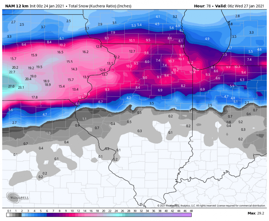
-
Jan 24-26th Potential Something Part 2
mimillman replied to Chicago Storm's topic in Lakes/Ohio Valley
End of the NAM run is very Euro-esque with snow continuing through most of the day Tuesday into Wednesday. -
Jan 24-26th Potential Something Part 2
mimillman replied to Chicago Storm's topic in Lakes/Ohio Valley
Ultimately no meaningful changes through 54 hours. If you’re in the defo band once the low starts moving East, it’s gonna rock. That would be DVN and LOT CWAs. Edit: There does look like less QPF in the defo band, but more backside snows as evidenced by the changes in central Nebraska. -
Jan 24-26th Potential Something Part 2
mimillman replied to Chicago Storm's topic in Lakes/Ohio Valley
Yes. The distribution is highly left skewed and is throwing off the mean. The mean here is not a fair representation, it’s underdone -
Jan 24-26th Potential Something Part 2
mimillman replied to Chicago Storm's topic in Lakes/Ohio Valley
Distribution of members is bimodal and the mean lies at the low end of the 2nd mode and well below the median. I studied statistics and these are all very, very good things -
Jan 24-26th Potential Something Part 2
mimillman replied to Chicago Storm's topic in Lakes/Ohio Valley
It gets shunted East at hour 45, phew. It’s stronger though. QPF is going to be juiced -
Jan 24-26th Potential Something Part 2
mimillman replied to Chicago Storm's topic in Lakes/Ohio Valley
SLP is 2mb stronger and approximately 150 miles northwest. This is going to be a crusher for south central Iowa -
Jan 24-26th Potential Something Part 2
mimillman replied to Chicago Storm's topic in Lakes/Ohio Valley
Great analysis, thanks for this. FWIW, looks like Kuchera maps have been hovering around 11-12:1 for most of the CWA, so seems reasonable and perhaps per your work above, upside from there. -
Jan 24-26th Potential Something Part 2
mimillman replied to Chicago Storm's topic in Lakes/Ohio Valley
I think warmer temps aloft and less lake enhancement on Monday will be compensated by the fact its mostly an overnight event. And just in time as Tuesday rolls around, low passes to our south, temps are colder and lake enhancement can begin -
Jan 24-26th Potential Something Part 2
mimillman replied to Chicago Storm's topic in Lakes/Ohio Valley
It’s still snowing over LOT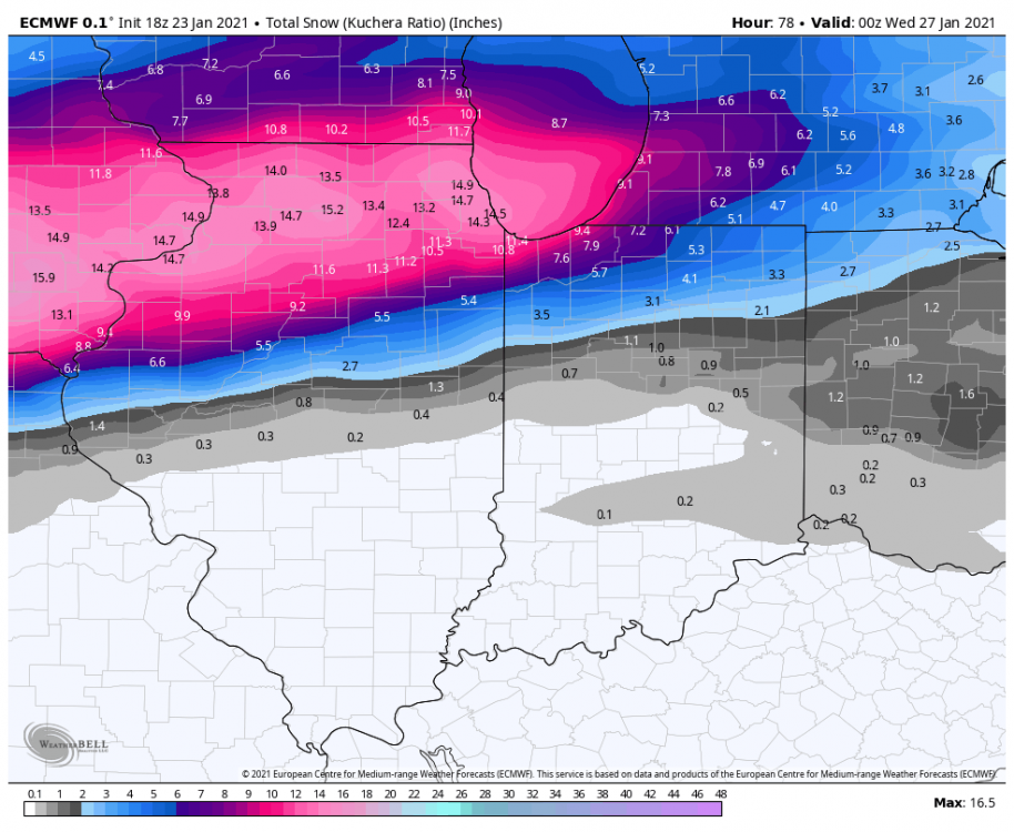
-
Jan 24-26th Potential Something Part 2
mimillman replied to Chicago Storm's topic in Lakes/Ohio Valley
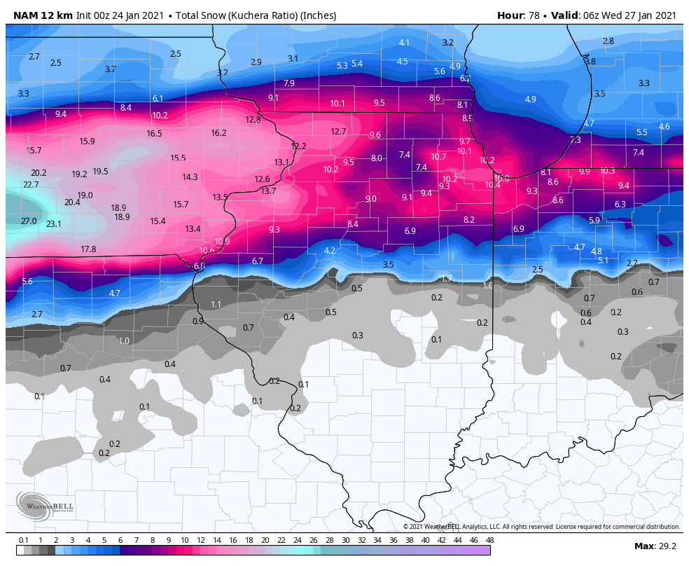
If you’re in LOT or DVN you love the 18z euro. Hard to get much better than that. Widespread 8-14”, long duration event -
Jan 24-26th Potential Something Part 2
mimillman replied to Chicago Storm's topic in Lakes/Ohio Valley
Thank the lord. It also doesn’t collapse QPF east as aggressively -
Jan 24-26th Potential Something Part 2
mimillman replied to Chicago Storm's topic in Lakes/Ohio Valley
I find it hard to believe this can go further north with the block honestly. And I don’t live in Indianapolis so you know I mean it -
Jan 24-26th Potential Something Part 2
mimillman replied to Chicago Storm's topic in Lakes/Ohio Valley
I don’t think we need to go there please. Horse has been long since dead -
Jan 24-26th Potential Something Part 2
mimillman replied to Chicago Storm's topic in Lakes/Ohio Valley
Gotta say, and I hope for my sake I’m right, I think the north drift is done