mimillman
-
Posts
3,468 -
Joined
-
Last visited
Content Type
Profiles
Blogs
Forums
American Weather
Media Demo
Store
Gallery
Everything posted by mimillman
-
Jan 24-26th Potential Something Part 2
mimillman replied to Chicago Storm's topic in Lakes/Ohio Valley
Ooof, heartbreak for the Delmarva peninsula -
Jan 24-26th Potential Something Part 2
mimillman replied to Chicago Storm's topic in Lakes/Ohio Valley
GFS...it’s drier but still fine
-
Jan 24-26th Potential Something Part 2
mimillman replied to Chicago Storm's topic in Lakes/Ohio Valley
Less so than previous runs -
Jan 24-26th Potential Something Part 2
mimillman replied to Chicago Storm's topic in Lakes/Ohio Valley
Hmm yea you’re right -
Jan 24-26th Potential Something Part 2
mimillman replied to Chicago Storm's topic in Lakes/Ohio Valley
RGEM is north. This is turning into a north central Iowa special. -
Jan 24-26th Potential Something Part 2
mimillman replied to Chicago Storm's topic in Lakes/Ohio Valley
Solid LE for Hoosier -
Jan 24-26th Potential Something Part 2
mimillman replied to Chicago Storm's topic in Lakes/Ohio Valley
It looks like a different system entirely. Main defo makes it to Madison -
Jan 24-26th Potential Something Part 2
mimillman replied to Chicago Storm's topic in Lakes/Ohio Valley
NAM starts off terrible and then improves. SREF down below 6” at ORD but that’s largely due to clunkers with majority of members 6-9” -
Winter 2020-21 Medium/Long Range Discussion
mimillman replied to Hoosier's topic in Lakes/Ohio Valley
Lol Hoosier please -
Jan 24-26th Potential Something Part 2
mimillman replied to Chicago Storm's topic in Lakes/Ohio Valley
Needs to go -
Jan 24-26th Potential Something Part 2
mimillman replied to Chicago Storm's topic in Lakes/Ohio Valley
Euro is less gung ho on lake effect -
Jan 24-26th Potential Something Part 2
mimillman replied to Chicago Storm's topic in Lakes/Ohio Valley
RGEM quite aggressive with the Wednesday lake effect. It’s going to be snowing here for like 36 hours -
Jan 24-26th Potential Something Part 2
mimillman replied to Chicago Storm's topic in Lakes/Ohio Valley
Thankfully yes. The RGEM and GEM are alone on the SW to NE axis -
Jan 24-26th Potential Something Part 2
mimillman replied to Chicago Storm's topic in Lakes/Ohio Valley
GEFS -
Jan 24-26th Potential Something Part 2
mimillman replied to Chicago Storm's topic in Lakes/Ohio Valley
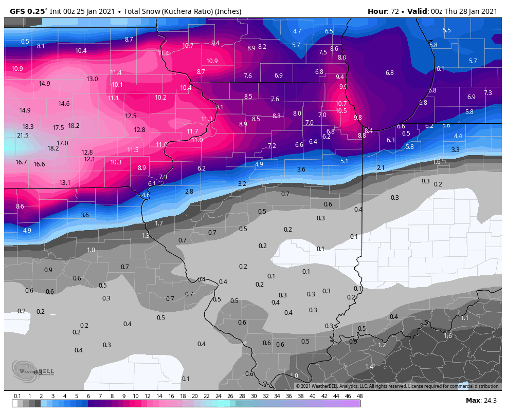
Was just going to say, the GFS is especially aggressive with the lake effect on Wednesday. All operational guidance has some form of lake effect signal now and just going to be a matter of honing in on exactly where it sets up, be it Lake IL, Cook, Lake IN, or Porter. I imagine where it is persistent you can add another couple inches to Tuesday storm total. -
Jan 24-26th Potential Something Part 2
mimillman replied to Chicago Storm's topic in Lakes/Ohio Valley
You mean the 5-8" vs. the 5-7"? Ok. -
Jan 24-26th Potential Something Part 2
mimillman replied to Chicago Storm's topic in Lakes/Ohio Valley
What if it misses to your south because of the 1045mb high in northern Nunavut province -
Jan 24-26th Potential Something Part 2
mimillman replied to Chicago Storm's topic in Lakes/Ohio Valley
Winter Storm Warning URGENT - WINTER WEATHER MESSAGE National Weather Service Chicago IL 255 PM CST Sun Jan 24 2021 ...Winter Storm to Impact the Region Beginning Monday Afternoon... ILZ006-013-103>107-250500- /O.UPG.KLOT.WS.A.0001.210125T2200Z-210126T2300Z/ /O.NEW.KLOT.WS.W.0001.210125T2200Z-210126T2300Z/ Lake IL-DuPage-Northern Cook-Central Cook-Southern Cook- Northern Will-Southern Will- Including the cities of Waukegan, Buffalo Grove, Mundelein, Gurnee, Naperville, Wheaton, Downers Grove, Lombard, Carol Stream, Evanston, Des Plaines, Schaumburg, Palatine, Northbrook, Chicago, Cicero, Oak Lawn, Oak Park, La Grange, Calumet City, Oak Forest, Lemont, Orland Park, Park Forest, Joliet, Bolingbrook, Plainfield, Mokena, Channahon, Manhattan, and Wilmington 255 PM CST Sun Jan 24 2021 ...WINTER STORM WARNING IN EFFECT FROM 4 PM MONDAY TO 5 PM CST TUESDAY... * WHAT...Snow, heavy at times, especially Monday evening and early overnight. Total snow accumulations of 5 to 8 inches. Isolated higher amounts possible. Northeast winds could gust as high as 35 to 40 mph resulting in periods of very low visibility. * WHERE...Portions of northeast Illinois. * WHEN...From late Monday afternoon through the day Tuesday. * IMPACTS...Travel could be very difficult. Hazardous conditions are likely to impact the Monday evening and Tuesday morning commutes. * ADDITIONAL DETAILS...Some power outages are possible due to the combined effects of the expected wetter nature of the snow and strong and gusty winds. Freezing rain, freezing drizzle, or sleet may mix in with the snow at times, mainly Monday evening for locations south of I-88. PRECAUTIONARY/PREPAREDNESS ACTIONS... If you must travel, keep an extra flashlight, food, and water in your vehicle in case of an emergency. The latest road conditions for Illinois can be obtained on the internet at www.gettingaroundillinois.com. && $$ -
Jan 24-26th Potential Something Part 2
mimillman replied to Chicago Storm's topic in Lakes/Ohio Valley
Ah yes, how could we forget about the 1045mb high 10,000 miles away -
Jan 24-26th Potential Something Part 2
mimillman replied to Chicago Storm's topic in Lakes/Ohio Valley
Iowa posters venturing into train wreck mode here. Might I suggest a nice cup of tea to calm the nerves, and some perspective. -
Jan 24-26th Potential Something Part 2
mimillman replied to Chicago Storm's topic in Lakes/Ohio Valley
Makes sense and sounds right given the trends. My initial call a couple days ago for 6-12" will hold, but highly likely to be on the lower end of that. NWS 6-9" in watch text is pretty spot on. -
Jan 24-26th Potential Something Part 2
mimillman replied to Chicago Storm's topic in Lakes/Ohio Valley
Growing confidence Lake and Cook counties will be QPF maxes in N IL -
Jan 24-26th Potential Something Part 2
mimillman replied to Chicago Storm's topic in Lakes/Ohio Valley
Fish -
Jan 24-26th Potential Something Part 2
mimillman replied to Chicago Storm's topic in Lakes/Ohio Valley
Really. Tell me more -
Jan 24-26th Potential Something Part 2
mimillman replied to Chicago Storm's topic in Lakes/Ohio Valley
In Cedar Rapids? Lowball.