HIPPYVALLEY
-
Posts
32,951 -
Joined
-
Last visited
Content Type
Profiles
Blogs
Forums
American Weather
Media Demo
Store
Gallery
Everything posted by HIPPYVALLEY
-

January 2026 regional war/obs/disco thread
HIPPYVALLEY replied to Baroclinic Zone's topic in New England
Ice fishing through March? -
January 2026 regional war/obs/disco thread
HIPPYVALLEY replied to Baroclinic Zone's topic in New England
I’m certainly not writing off the possibility, just skeptical right now. -
January 2026 regional war/obs/disco thread
HIPPYVALLEY replied to Baroclinic Zone's topic in New England
Congrats RIC -
January 2026 regional war/obs/disco thread
HIPPYVALLEY replied to Baroclinic Zone's topic in New England
Suppression threat is real.
-
January 2026 regional war/obs/disco thread
HIPPYVALLEY replied to Baroclinic Zone's topic in New England
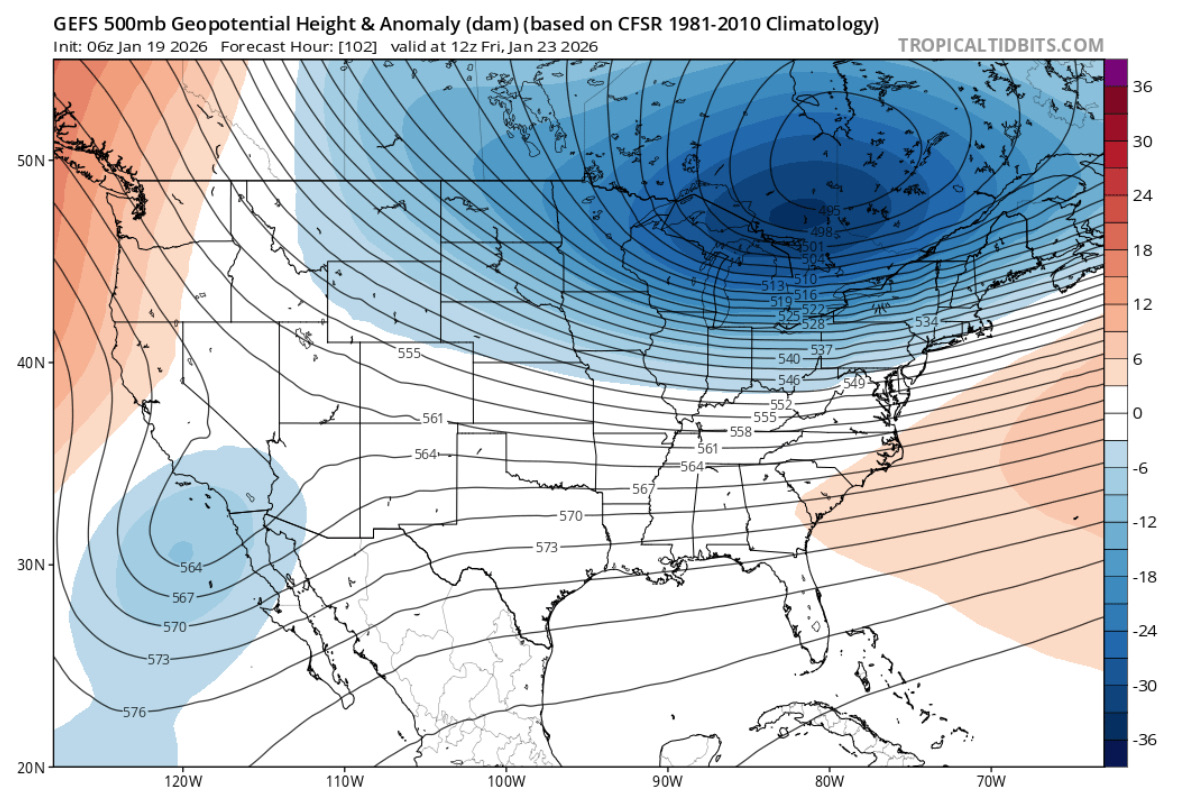
Cold and dry next weekend is the likely outcome. -
Rise of the Machines: January 18-19 Winter Storm Obs Thread
HIPPYVALLEY replied to WxWatcher007's topic in New England
Bright blue skies breaking out here already. -
Rise of the Machines: January 18-19 Winter Storm Obs Thread
HIPPYVALLEY replied to WxWatcher007's topic in New England
Oh’ you guys did well. Only 1” in the valley. -
January 2026 regional war/obs/disco thread
HIPPYVALLEY replied to Baroclinic Zone's topic in New England
I think -16F is my record low since moving to Greenfield. Challenging that is impressive. -
Rise of the Machines: January 18-19 Winter Storm Obs Thread
HIPPYVALLEY replied to WxWatcher007's topic in New England
You guys have a snow board for measuring, right? -
Rise of the Machines: January 18-19 Winter Storm Obs Thread
HIPPYVALLEY replied to WxWatcher007's topic in New England
I think we knew WNE was certainly a long shot with this one. I'm just happy to dust up yesterday's bounty and be happy for Eastern peeps. -
Rise of the Machines: January 18-19 Winter Storm Obs Thread
HIPPYVALLEY replied to WxWatcher007's topic in New England
We'll end pretty close as usual. 6.5" yesterday and .50" tonight. -
January 2026 regional war/obs/disco thread
HIPPYVALLEY replied to Baroclinic Zone's topic in New England
Dave and Ineedfrozen are in the magic twilight zone. You know me, throw a moisture laden SWFE at us and I'm all in! An ideal winter, is a month long parade of those, with a coastal or two that throws sloppy seconds WOR. -
Rise of the Machines: January 18-19 Winter Storm Obs Thread
HIPPYVALLEY replied to WxWatcher007's topic in New England
Bro, you were melting. You had to know the goods were coming based on radar and modeling. -
Rise of the Machines: January 18-19 Winter Storm Obs Thread
HIPPYVALLEY replied to WxWatcher007's topic in New England
You guys are doing better than I thought based on radar. Although, radar is paltry here but still steady baking powder. -
January 2026 regional war/obs/disco thread
HIPPYVALLEY replied to Baroclinic Zone's topic in New England
Might be suppression issues for both of us but you are poised to clean up in a coastal. -
January 2026 regional war/obs/disco thread
HIPPYVALLEY replied to Baroclinic Zone's topic in New England
Next few weeks look cold. Hopefully we can get something juiced riding into the cold dome but we are certainly primed to have some epic pond ice. I know how that tickles so many fancies. -
Rise of the Machines: January 18-19 Winter Storm Obs Thread
HIPPYVALLEY replied to WxWatcher007's topic in New England
Prolly good for 2 more tho’ -
Rise of the Machines: January 18-19 Winter Storm Obs Thread
HIPPYVALLEY replied to WxWatcher007's topic in New England
Hopefully, you beat that tonight. -
Rise of the Machines: January 18-19 Winter Storm Obs Thread
HIPPYVALLEY replied to WxWatcher007's topic in New England
You have to figure there will be a few by the time this winds down. -
Rise of the Machines: January 18-19 Winter Storm Obs Thread
HIPPYVALLEY replied to WxWatcher007's topic in New England
Nice, is this your highest total of the season? -
Rise of the Machines: January 18-19 Winter Storm Obs Thread
HIPPYVALLEY replied to WxWatcher007's topic in New England
See, you had nothing to worry about when it was raining earlier. -
Rise of the Machines: January 18-19 Winter Storm Obs Thread
HIPPYVALLEY replied to WxWatcher007's topic in New England
Steady light snow in Greenfield now. 29° medium sized flakes. -
Rise of the Machines: January 18-19 Winter Storm Obs Thread
HIPPYVALLEY replied to WxWatcher007's topic in New England
Eh, not really. I guess for those that had unrealistic expectations maybe? -
Rise of the Machines: January 18-19 Winter Storm Obs Thread
HIPPYVALLEY replied to WxWatcher007's topic in New England
I'm expecting C - 1" in Greenfield. I think @ineedsnowmay need to reel in expectations for N ORH Co... -
Rise of the Machines: January 18-19 Winter Storm Obs Thread
HIPPYVALLEY replied to WxWatcher007's topic in New England
No fog here today, but last night was surreal. Everything caked in snow and foggy.