

HIPPYVALLEY
-
Posts
32,949 -
Joined
-
Last visited
Content Type
Profiles
Blogs
Forums
American Weather
Media Demo
Store
Gallery
Everything posted by HIPPYVALLEY
-
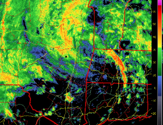
 Jeezuz, storms just keep popping up north of Brattleboro and sliding right down the valley. Pouring again.
 -
Picked up another .25” in Greenfield.
-
5.2” in Greenfield.
-
5.5” and raining again. Yeah, the frogs were crazy tonight walking the dog.
-
It’s been a boring summer, but today was some of the heaviest sustained rain bands I’ve ever seen. So that was kind of neat.
-
Greenfield has gotten that much in the past 15 minutes.
-
Fak’ dumping!
-
Holy downpour! Make that 3”+ now.
-
2.8” at mi casa.
-
Greenfield around 1.25” now.
-
Just got .20” in about 10 minutes.
-
Always in warm months, never in cold months.
-
It's going to be some very specific corridors of haves and have nots.
-
Double IPAs will do that to you.
-
Nada in Greenfield.
-
You are free to leave anytime you want, bruh’! I bet there’s a few on here that would even come help load up the moving van for you.
-
Got down to 48°.
-
Saturday, July 18, 2026 Thunderstorm/Severe Weather Potential
HIPPYVALLEY replied to weatherwiz's topic in New England
Great moderate soaking rain for at least an hour here today. Yard is happy. -
I’m not used to this weather. The breeze is a little bit chilly. I don’t like oppressive heat, but I do like to be warm in the summer. I especially like warm evenings and tonight is not that.
-
Saturday, July 18, 2026 Thunderstorm/Severe Weather Potential
HIPPYVALLEY replied to weatherwiz's topic in New England
-
seems fine
-
Yeah, it’s been weird how dark it’s been for the past four hours.
-
It’s like 8 PM dark in downtown Greenfield right now. Crazy.
-
Peaked at 84° today in downtown Greenfield. It was definitely humid, but steady breeze all day.


