michaelmantis
-
Posts
269 -
Joined
-
Last visited
Content Type
Profiles
Blogs
Forums
American Weather
Media Demo
Store
Gallery
Everything posted by michaelmantis
-
Mid-week potential of something somewhere
michaelmantis replied to Chicago Storm's topic in Lakes/Ohio Valley
This data looks to be from the 3-4 AM model runs... How could they still be using it?!?!? -
Mid-week potential of something somewhere
michaelmantis replied to Chicago Storm's topic in Lakes/Ohio Valley
Thanks for posting, was looking for that link! I can almost understand a lake-effect scenario (the 2016 situation) causing that huge spread in amounts but this storm in question here was not a "lake effect" storm for N IL (while it may have lake moisture influences). I have no meteorological background, just a big interest, so I'm not going to throw stones. But all of this needs to be publicly corrected by the afternoon updates as we are now close to 24 hours out and those who just watched the evening or morning news have no idea of the latest updates and in many cases huge snowfall numbers are still being publicized. All this being said, wouldn't it be something if with this winter this thing makes a last minute shift north after all the forecasts are updated this afternoon? Mother nature messing with everyone. -
Mid-week potential of something somewhere
michaelmantis replied to Chicago Storm's topic in Lakes/Ohio Valley
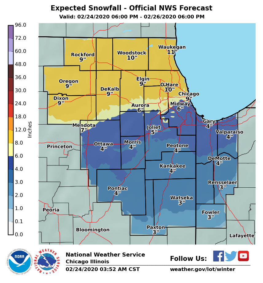
LOTs update does not provide much insight into their thinking into how the amounts change over the area. They do mention a sharper cut off during the day on Tuesday near the IL/WI border but if any of the current models verify, there is no way this is even an advisory in the first few tier of counties in N IL right? My underlining below. https://forecast.weather.gov/product.php?site=LOT&issuedby=LOT&product=AFD&format=CI&version=1&glossary=1 -
Mid-week potential of something somewhere
michaelmantis replied to Chicago Storm's topic in Lakes/Ohio Valley
Even you ALEK would have bet some money on those odds at a casino right? :-) -
Mid-week potential of something somewhere
michaelmantis replied to Chicago Storm's topic in Lakes/Ohio Valley
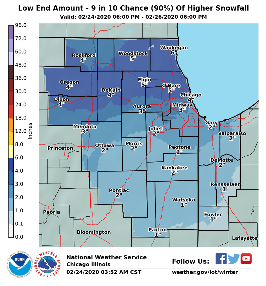
Posting this (data from 4 AM it looks like) to see these totals drop off a cliff with the 3 PM update. Even the 10% probability map had 4+ inches north of I-88 all the way across the entire state. https://www.weather.gov/lot/winter

-
Mid-week potential of something somewhere
michaelmantis replied to Chicago Storm's topic in Lakes/Ohio Valley
I feel for you guys making these decisions. From a forecasting perspective (and academically for lack of a better word) knowing that someone within a 50-75 mile range is going to get a big snow means you hit the mark as a forecasting office but that doesn’t help the PR side of things for the person who was told they were going to get a “big” storm and ends up with what they perceive as nothing. Doesn’t help that there are now so many models that people have access to that start bringing attention (or hyping more likely) an “event” before all the data is there to make a reasonable forecast. Still need the forecast to be like Back to the Future 2 where Doc Brown says “too bad the postal service isn’t nearly as efficient as the weather service” as he counts down the end of a rainstorm to the second. :-) -
Mid-week potential of something somewhere
michaelmantis replied to Chicago Storm's topic in Lakes/Ohio Valley
Second that... I'm not going to lose sleep tonight waiting for the next models overnight... With all of this uncertainty I don't see how LOT makes major changes until the 3 PM updates tomorrow... -
Mid-week potential of something somewhere
michaelmantis replied to Chicago Storm's topic in Lakes/Ohio Valley
I feel you... For us this seems like the best shot of a biggie thus far this year... 24 hours will see where that wobble leads to the good snow... -
Mid-week potential of something somewhere
michaelmantis replied to Chicago Storm's topic in Lakes/Ohio Valley
The cutoffs in N IL in the forecasts really make messaging storms like this tricky. A 25 mile change impacts a huge population area. I will say this is the best the "Probabilistic Snowfall Forecast" graphic has looked for me all winter, especially 36ish hours from the event... Fingers crossed... https://www.weather.gov/lot/winter -
It will all melt a day later in this pattern... Have a winter camp out with my daughter next weekend and would *LOVE* a good snow. Last year there was just like the map above... 12 inches of snow in Southern Wisconsin on Thursday and then it POURED rain most of the weekend... It was a sloppy muddy mess...
-
As a weather forecaster that has to be a depressing thing to say huh? :-) Top 5 event would be, maybe, possibly, a 3 hour burst of heavy snow rates?!?! Thanks for all the informative posts. Love the banter here (Go Alex!) but also nice to have someone posting with some insider/expert info!
-
February 4th-7th Winter Storm Potential
michaelmantis replied to Thundersnow12's topic in Lakes/Ohio Valley
Damn, that cut off is sharp. 9.1 to 0.9 in 20 miles (as the crow flies). Someone along the lake is going to get an extra dollop I bet. -
February 4th-7th Winter Storm Potential
michaelmantis replied to Thundersnow12's topic in Lakes/Ohio Valley
Sweet setup for those that get lucky. Now if that purple moved about 30 miles NW I’d be happy but with this winter I would just be happy to get a fresh coat of white. -
January 22nd-25th Winter Storm Potential
michaelmantis replied to Thundersnow12's topic in Lakes/Ohio Valley
Really trying to figure out if this is good sledding weather... High risk of soaked boots! -
January 22nd-25th Winter Storm Potential
michaelmantis replied to Thundersnow12's topic in Lakes/Ohio Valley
I was just going to ask the question where the best location is going to be. Now that the crappy rain is gone, this thing looks great on radar if you are north of I-88. Precip is also starting to fill in south along I-47. Aurora to Downtown Chicago has been the southernmost extent of the snow for a while. -
January 22nd-25th Winter Storm Potential
michaelmantis replied to Thundersnow12's topic in Lakes/Ohio Valley
Exactly! I wish they did more updates and "nowcasts" during events like this but know they have an actual job to do! Today's was a great AFD. ...near Warning criteria snowfall before all is said and done, somewhere in the I-90 corridor vicinity across parts of Kane, McHenry, Lake, and far northwest Cook County. -
January 22nd-25th Winter Storm Potential
michaelmantis replied to Thundersnow12's topic in Lakes/Ohio Valley
Nice cutoff in IL through I-88. My goodness. I'm riding the edge here a few miles south of I-90. -
January 22nd-25th Winter Storm Potential
michaelmantis replied to Thundersnow12's topic in Lakes/Ohio Valley
I’m sure of that right about now. Back to some drizzle here but less than 3 miles down the road it’s pouring snow. -
January 22nd-25th Winter Storm Potential
michaelmantis replied to Thundersnow12's topic in Lakes/Ohio Valley
Damn that changed fast... Cotton balls falling now... Temp took another 1.5 degree drop... -
January 22nd-25th Winter Storm Potential
michaelmantis replied to Thundersnow12's topic in Lakes/Ohio Valley
Dropped 1.5 degrees in an hour (35 now). The backyard is a slushy muddy mess. -
January 22nd-25th Winter Storm Potential
michaelmantis replied to Thundersnow12's topic in Lakes/Ohio Valley
Pouring rain by me... 36 as measured by backyard weather station... Such good precipitation gone to waste!!! Change quick damnit! ;-) -
January 22nd-25th Winter Storm Potential
michaelmantis replied to Thundersnow12's topic in Lakes/Ohio Valley
Literally in the center of the bulls eye of the 9.1/9.3 on that map... Lock it in!!! Just need some favorable winds off the lake and a few bands setting up nicely for at least 1/2 of that to pan out... Regardless, it has looked pretty out there much of the last 36 hours... Finally like winter!!! -
January 22nd-25th Winter Storm Potential
michaelmantis replied to Thundersnow12's topic in Lakes/Ohio Valley
+1 Here! ;-) My area seems to get those unexpected lake plumes (even 25ish miles from the lake) and quirky precip bumps that have created a couple of nice storms. Edit 2:20 PM - Just had a few minutes of some quarter-sized monster flakes fall. Crazy. Quick covering of the now melted and plowed street... -
January 22nd-25th Winter Storm Potential
michaelmantis replied to Thundersnow12's topic in Lakes/Ohio Valley
1.5 inches here as of an hour ago and been lightly snowing for the last hour. Side street snow covered. -
January 22nd-25th Winter Storm Potential
michaelmantis replied to Thundersnow12's topic in Lakes/Ohio Valley
I remember that storm and almost was dead center of the bullseye in Kane County. I was working from home that day and the snow just kept coming.