The_Global_Warmer
-
Posts
9,970 -
Joined
-
Last visited
Content Type
Profiles
Blogs
Forums
American Weather
Media Demo
Store
Gallery
Everything posted by The_Global_Warmer
-

December 16-17, 2020 Storm Observations and Nowcast
The_Global_Warmer replied to wdrag's topic in New York City Metro
That's because my boy forkyfork is in Jersey holding the sleet progression off!! -
December 16-17, 2020 Storm Observations and Nowcast
The_Global_Warmer replied to wdrag's topic in New York City Metro
So what's the deal with that double like line in the wedge. The western side almost parallel with Long island but it looks like there's like a wedge there that's crazy I mean I get it I understand the wind Dynamics but is that something else. Hopefully the f****** line slows down for you guys. I won't lie a part of me is jealous and I want you to get screwed but a bigger part of me is hopefully you guys get the snow you want because we all know how crappy it is to get screwed by sleep and rain. unlike living up in Vermont and New Hampshire and freaking Worcester Massachusetts which is like the snow capital of America. Yeah you know who I'm talkin about I got mad respect for you I know this ain't your forum but damn you always win DARTH VADER! ANYWAYS GOOD LUCK EVERYBODY ON THE ISLAND
-
2019 ENSO
The_Global_Warmer replied to AfewUniversesBelowNormal's topic in Weather Forecasting and Discussion
DAMN!! HOLY SHIT Looking rough for NINO3 I HAVEN'T SEEN EASTERLIES THIS STRONG IN A HELL OF A LONG TIME. -
2019 ENSO
The_Global_Warmer replied to AfewUniversesBelowNormal's topic in Weather Forecasting and Discussion
The equatorial winds like cant get any better for setting up nine. Given the last 90 days I would expect the sub surface to be much cooler. Given the wind forecast a deep cold pool should redevelop. Geezus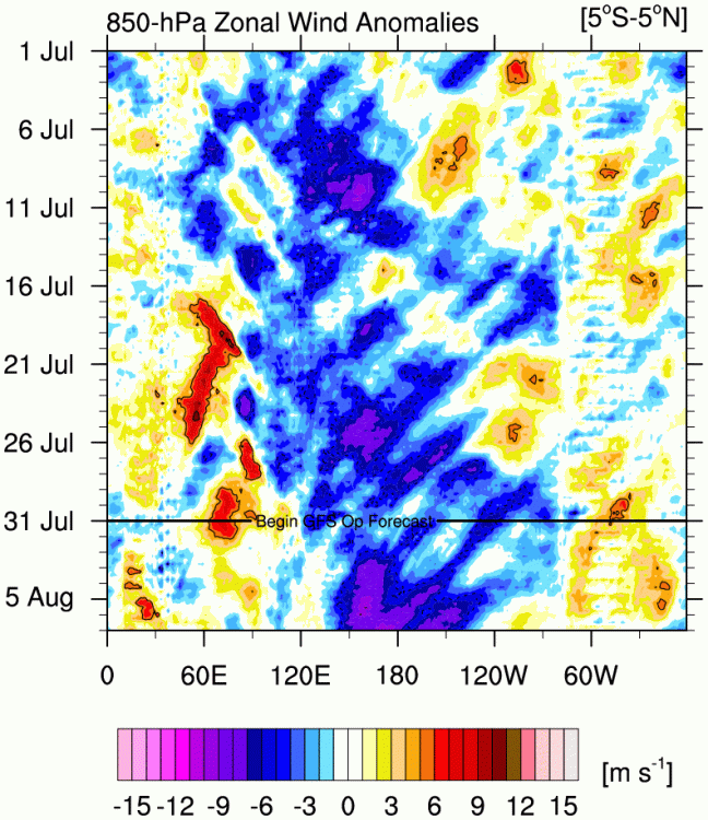
-
Arctic Sea Ice Extent, Area, and Volume
The_Global_Warmer replied to ORH_wxman's topic in Climate Change
On 7/15/2020 at 11:14 PM, donsutherland1 said: Arctic sea ice extent fell to 6.996 million square kilometers (JAXA) today. The previous earliest figure below 7 million square kilometers was July 19, 2011 when extent was 6.995 million square kilometers. From the Arctic sea ice forum. -
Enso is transitioning to a possible moderate to strong Nina. Could be a 2 yr+ one. Equatorial sub-surface temps have plummeted.
-
Arctic Sea Ice Extent, Area, and Volume
The_Global_Warmer replied to ORH_wxman's topic in Climate Change
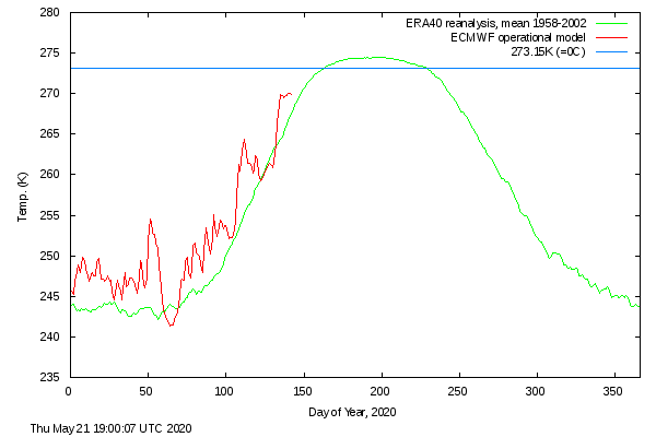
I haven't posted here in a long time because the Arctic sea ice forum is way more active. And because the Arctic has hit a wall in Spring with all of the anomalous factors that have lead to the ice change the last couple of decades. Part of it is because the pattern hasn't seen a June dipole/sun bath since 2012. The recent essentially record warm/anomalous ridge was incredible. And for a few days Arctic sea ice albedo really dropped over a large portion of the basin. However as soon as the pattern changed the ice surface couldn't retain it's wetness. It has refroze. Not all the way back to before the ridge but quite a bit. This tells me that solar altitude cannot overcome dry snow/ice albedo in middle of May. Which means in the future in order to get the powerful solar insolation to actually kick start the melt season in middle May will require ambient conditions to be warmer to reinforce the solar insolation Like snow cover melt happening 1-2 weeks earlier than it ever has along the Arctic Arctic coast and river Delta's opening up earlier as well. This would allow the near surface lower troposphere to warm quite a bit faster than it currently does. Essentially to get a record this summer we will have to go back to a highly anomalous dipole. The CAA has been spared for a while. Anyways right now everything is set up for a potential record Ice loss summer thanks to the UNBELIEVABLE RIDGE that rolled through the basin.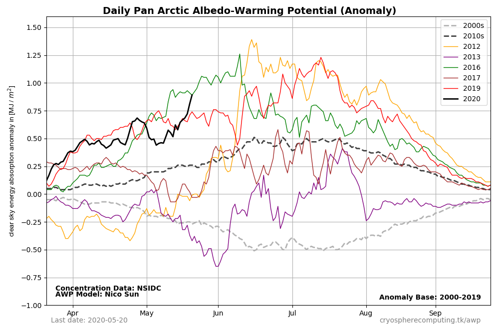
-
2019 ENSO
The_Global_Warmer replied to AfewUniversesBelowNormal's topic in Weather Forecasting and Discussion
Equatorial winds lessened this week. But are forecasted to explode again over Enso 3-4. If this wind forecast happens we will definitely negative anomalies really pick up over all of Enso 3 and push into enso 4..thumb.gif.3adc4a758c336e9612ee44ebd3b67601.gif)
-
2019 ENSO
The_Global_Warmer replied to AfewUniversesBelowNormal's topic in Weather Forecasting and Discussion
Man the setup is quickly getting primed for a major la nina..thumb.gif.eb71baf8053bdaea1a0d7836768d6dd6.gif)
-
2019 ENSO
The_Global_Warmer replied to AfewUniversesBelowNormal's topic in Weather Forecasting and Discussion
Holy smokes the warm surface has been decimated. Major la Nina incoming....thumb.gif.548096436e86788eda16d1ed6026896f.gif)
.thumb.gif.ad71934258dfcc026fdbb7964fd33f09.gif)
-
2019 ENSO
The_Global_Warmer replied to AfewUniversesBelowNormal's topic in Weather Forecasting and Discussion
I think the coming Nina will be stronger than 95-96. Somewhere along the lines of 99-01 and 07-09(early). I can't see an event that lasts 3+ years. Could definitely see a nina-neutral-weakquicknina-nuetral-nino. Over 2020-2022. We'll see -
2019 ENSO
The_Global_Warmer replied to AfewUniversesBelowNormal's topic in Weather Forecasting and Discussion
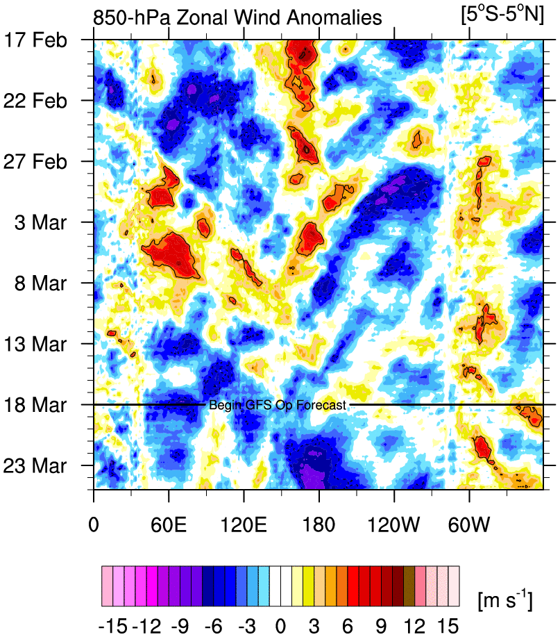
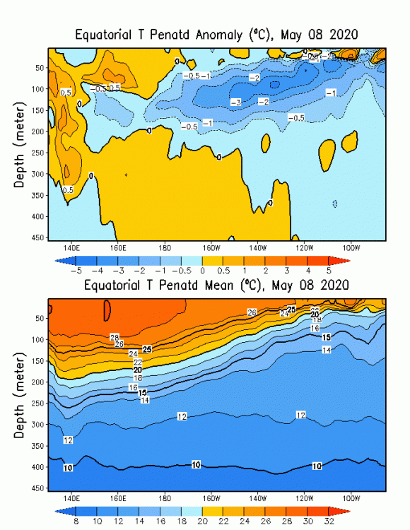
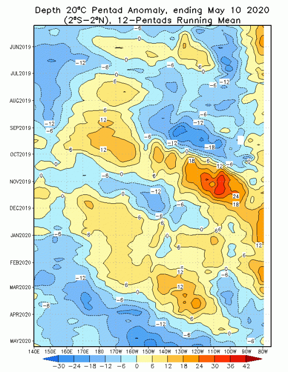
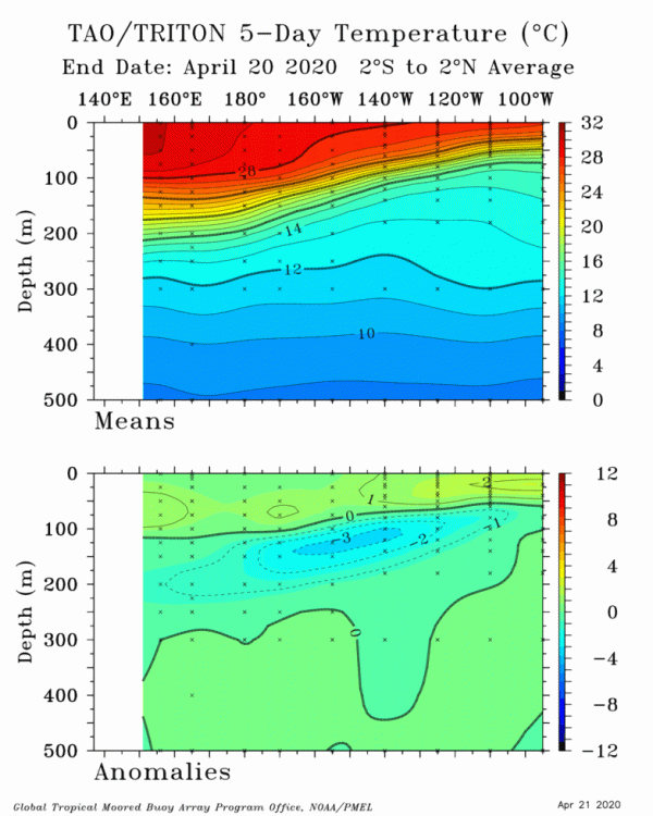
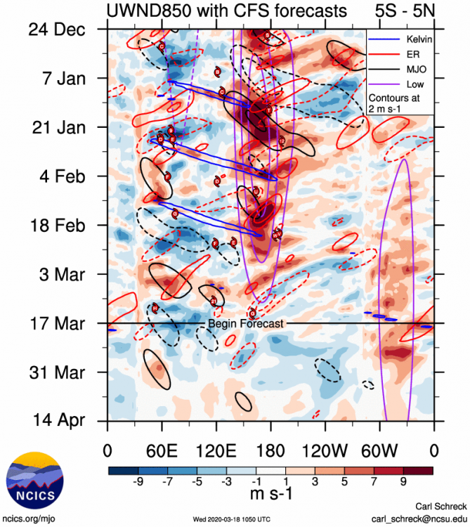
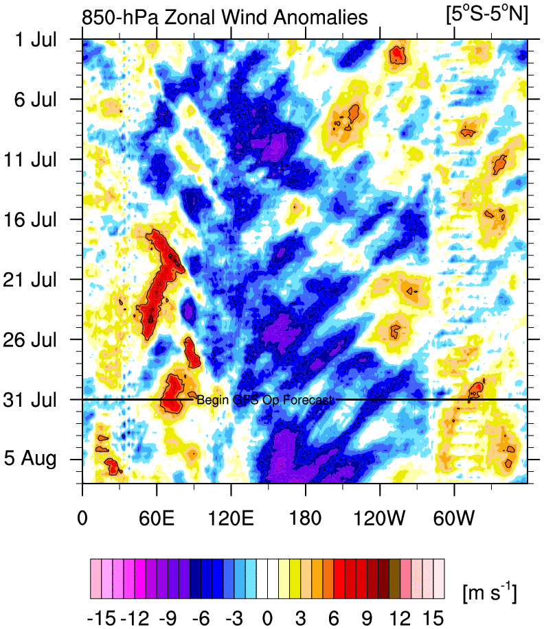
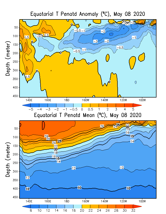
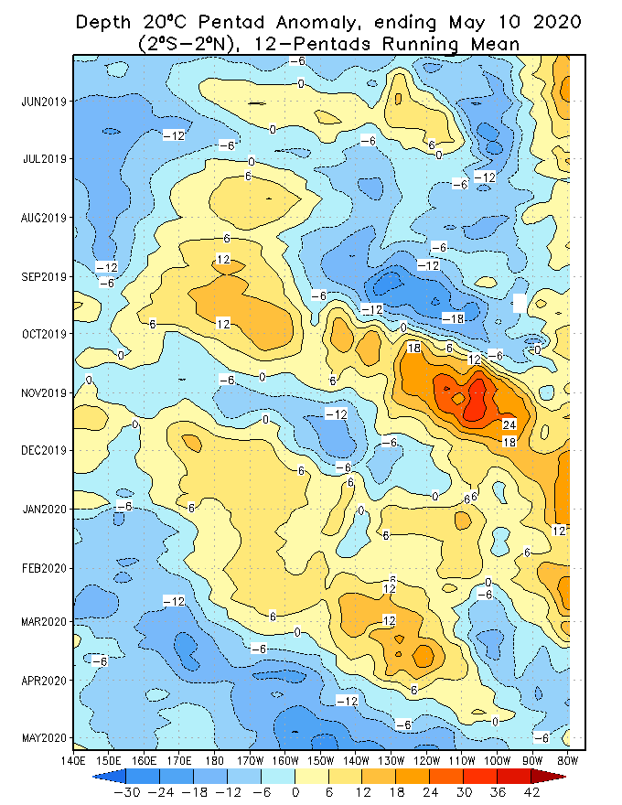
The subsurface negative anomalies are a little different than most the last few years that werd much further East than the current cold pool forming over the central Pacific with legs all the way back into the Western Pacific. Thanks to persistence of the Easterly equatorial winds being anonymously stronger than the average for this time of year the warm surface is already being eradicated as far West as 120W. The equatorial wind forecast continues to be even more anomalous in favor of intense (relative to swaying equatorial surface sea temps towards one extreme on the enso plane. I attached the wind forecast below that also has the recent observed winds. It is straight ridiculous. From essentially all of Enso 3 and Enso 4 we see anonymously strong Easterly winds that really pummel the central Pacific. This will allow the sub surface cold pool to keep stretching Eastwards towards surfacing near South America. While the near surface positive anomalies will continue to be eroded but still slowly thanks to: A decently deep reach of the warm pool. Global warming which has a hard to define very slight bias towards slight anomalous warmth overtime versus when the normal values we're established this is very hard to quantity but is clearly a real thing when you consider the current warm anomalies are always in larger surface area globally versus the established normal 10-40 years ago or 20-50 or 10-50. However you define it. And seasonal variance with the northern hemisphere going into slightly stronger radiative presence this time of year. Which is amplified by heat trapping gases. This is get hard to define statistically but we know it's real for the same reasons as argued above. Either way the set up for a MAJOR NINA EVENT IS UNDERWAY. WILL THIS TRANSLATE INTO A MAJOR NINA DURING THE UPCOMING COOL SEASON???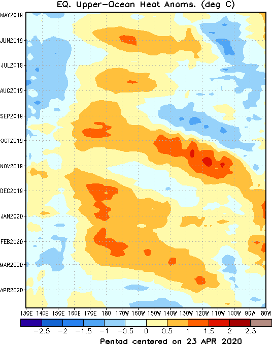
.thumb.gif.0f7c703b8736f2989125178825eaeadd.gif)
.thumb.gif.6c7bc8e6de3dc4a880f78ac85d943d4d.gif)
-
2019 ENSO
The_Global_Warmer replied to AfewUniversesBelowNormal's topic in Weather Forecasting and Discussion
There a huge Nina blitzkrieg
-
2019 ENSO
The_Global_Warmer replied to AfewUniversesBelowNormal's topic in Weather Forecasting and Discussion
.com.google.Chrome.Qa85v0 -
2019 ENSO
The_Global_Warmer replied to AfewUniversesBelowNormal's topic in Weather Forecasting and Discussion
The warmth really didn't build up very well inspite of a mostly negative soi. Even so it will take a while before that warm layer Poof's. But if winds go nuts for a Nina. We could deep dive into it. Tho it wont take much for the warm pool to quickly reestablish itself out West..thumb.gif.c34e245fa7849c2d397c59edc6ec2cae.gif)
-
2019 ENSO
The_Global_Warmer replied to AfewUniversesBelowNormal's topic in Weather Forecasting and Discussion
Equatorial winds suggest a plunge towards la Nina conditions will become favorable as winds currently and forecasted to remain enhanced Easterlies helping totally destroy the slim warm anomolous surface. -
2019 ENSO
The_Global_Warmer replied to AfewUniversesBelowNormal's topic in Weather Forecasting and Discussion
In the short term 120w to the SA might see the cold pool knocked down a bit because of favorable winds. But West of there the winds become anomously stronger Easterlies. This will allow the growing cold pool to get closer to the surface and grow in size..thumb.gif.0aeefe0332ed895bc8225efbcc0291c5.gif)
-
2019 ENSO
The_Global_Warmer replied to AfewUniversesBelowNormal's topic in Weather Forecasting and Discussion
Winds continue to favor pushing the near surface layer West at a faster rate (0-75M). This will slowly decay the warm layer near the surface East of 160W. While a cool pool tries to develop around 160-140W towards the SA coast. Gently sloping from 150M-75M subsurface(160-130W) sloping towards the surface in the nino 1-2 area. 150-180E/W looks to gain heat subsurface..thumb.gif.46490da1f2e8e2d6f0256d3429cbdb5c.gif)
-
That is amazing thanks for posting
-
2019 ENSO
The_Global_Warmer replied to AfewUniversesBelowNormal's topic in Weather Forecasting and Discussion
Latest wind forecasts along the equatorial belt in the Pacific go cliff diving in favor of enhanced Easterlies over the entire ENSO geographical region..... This is the start of an eventual Lanina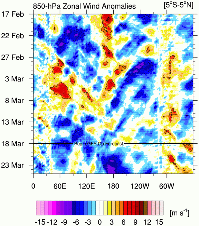
-
2019 ENSO
The_Global_Warmer replied to AfewUniversesBelowNormal's topic in Weather Forecasting and Discussion
You would think we would be setting up for a major EL NINO heading into Spring next year. But the sub surface while leaning warm is not primed for strong Nino.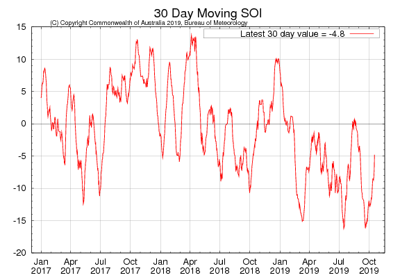
-
Arctic Sea Ice Extent, Area, and Volume
The_Global_Warmer replied to ORH_wxman's topic in Climate Change
What the models show for early October is nothing short of Epic. -
Arctic Sea Ice Extent, Area, and Volume
The_Global_Warmer replied to ORH_wxman's topic in Climate Change
The models show what is probably unprecedented for this time of year. The refreeze will completely stop. Well it really hasnt even begun outside the CAA. But it will flatline easily for 10-14 days. I mean like zero growth.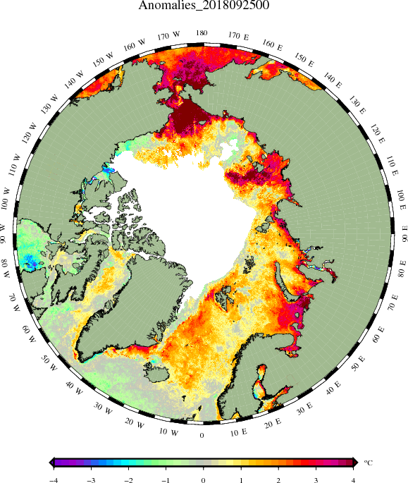
-
Arctic Sea Ice Extent, Area, and Volume
The_Global_Warmer replied to ORH_wxman's topic in Climate Change
After day 5 the euro diverges from the gfs and cmc. The latter two have a scenario where the ESS, Chuchku region, and laptev all see tremendous ice loss for August. Throw the CAB into that as well. The euro has a more tamed version. Likely due to NPAC differences. -
Arctic Sea Ice Extent, Area, and Volume
The_Global_Warmer replied to ORH_wxman's topic in Climate Change
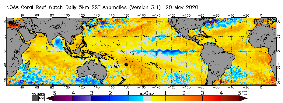
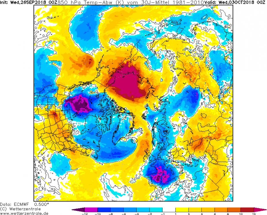
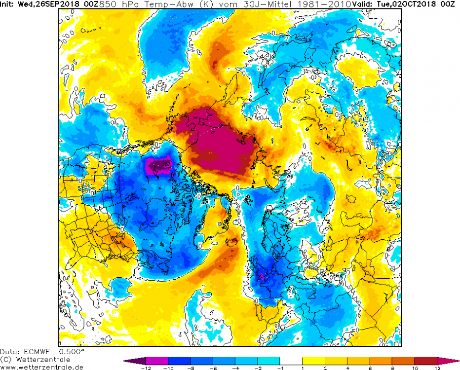
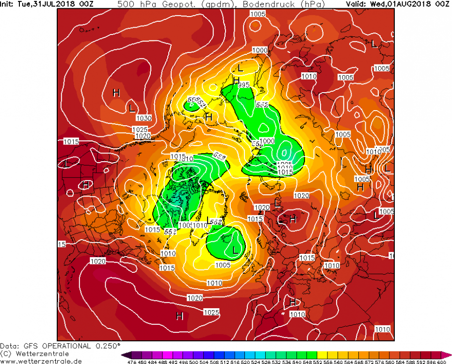
Anyways, here is the gfs forecast 24-hrs out and ssta from the Dutch. The axis of tremendous heat is wheeling towards the Arctic basin and NEGIS. This has recently dumped a lot of heat into the oceanic near surface layer.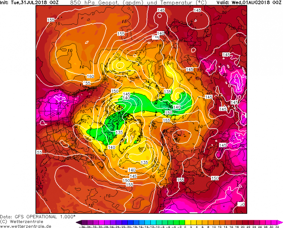
.png.0bf93d8adf0c0187afd3efd47e48eb59.png)

.gif.c67991066656cbead1d4d141b964eed1.gif)
.gif.7d1aa51af098b02fca03495e2b2a9300.gif)
.gif.dc6ba6aeda511a31c7afeb95913de75f.gif)
.gif.3c55fc5016f72a8f93d58b1a6fab2b03.gif)
.gif.25aa1e3692530221798e4d397646c368.gif)
.gif.cbffc9b682cf90944694306b60ecf959.gif)
.gif.62c0979206ff38df60cd4801f737cfc4.gif)
.gif.e067534eca31544a2da4307d74863a9e.gif)
.gif.da29f482d60e9ffccb16bf1be69ef4f8.gif)