CAD_Wedge_NC
-
Posts
2,435 -
Joined
-
Last visited
Content Type
Profiles
Blogs
Forums
American Weather
Media Demo
Store
Gallery
Everything posted by CAD_Wedge_NC
-

2020/2021 Fall/Winter Mountain thread
CAD_Wedge_NC replied to Met1985's topic in Southeastern States
Yeah, it looks like an elevation dependent event as of right now. However, it's been trending better for us foothills folks too. -
That map will change many times before verification. Stick with the ensembles for long range forecasting.
-
This is going to be a good month. I can feel it. Currently foggy conditions and 50 degrees
-
I'll say this..... if the long range pattern comes to fruition, we will be tracking some big dogs in the next couple of weeks. I have not seen a better pattern than what's being forecasted in many years. This is what we have all been waiting on......
-
See, now that's where we differ...... Cold weather is needed for the ski industry in the Southern Apps. I don't care if I get 0 snow, as long as it's cold enough for them to make snow. A lot of folks' jobs are dependent on the cold. Let's not be selfish.
-
I don't understand the whining. This winter was supposed to be a wall-to-wall torch. Let's just be thankful we are not looking at a strong SE ridge and 75 degrees everyday. The pattern could be a lot worse.
-
NWS not buying it. Not even a mention of clouds in the forecast. Down-sloping makes it almost impossible to get any snow here in the lee.
-
23.9 degrees this morning with a very heavy frost. Even the shrubs are white.
-
Ice Time? Dec. 16ish Possible CAD Event
CAD_Wedge_NC replied to Tar Heel Snow's topic in Southeastern States
Wait,,, what?.... I am confused....... Oh, I see now, you are talking about Greenville NC. Yeah, CAD storms don't really affect you guys. -
Ice Time? Dec. 16ish Possible CAD Event
CAD_Wedge_NC replied to Tar Heel Snow's topic in Southeastern States
I always look for a number of things to determine whether we will get a freezing rain event or not. This looks to be a very good example for the classical CAD event. 1) You want to see 850 Mb temperatures of -20C in ME (we have that) Check 2) You need that 540 line in Virginia (we have that) Check 3) A 1030+ high pressure around upstate NY (slightly north with this one) Check 4) Soil temps are important as well (no frozen ground with this one) Concerning but not a show stopper -
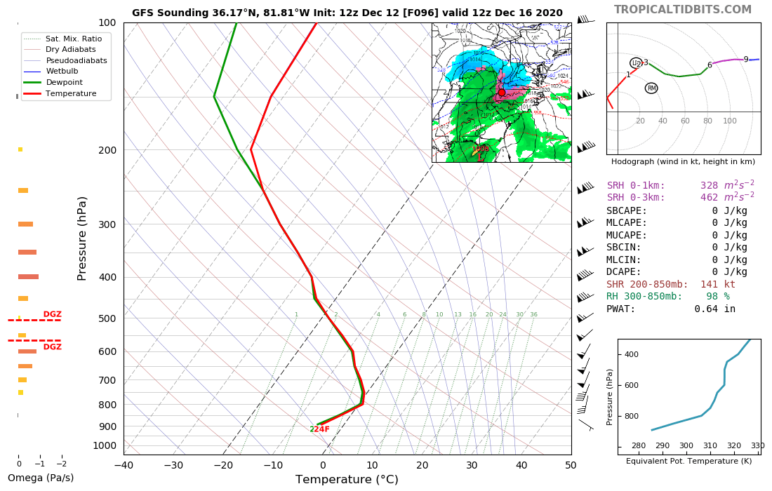
2020/2021 Fall/Winter Mountain thread
CAD_Wedge_NC replied to Met1985's topic in Southeastern States
Across the NC mtns and higher elevations of the Upstate and NE GA, snow will be the main p-type, where a few inches are possible across the srn escarpment and lower totals to the north. A lot can change with this system and the fcst will be adjusted over the next few days. One to keep an eye on. NWS seems to think the higher elevations will be ok.(excerpt from their afternoon discussion) Looking at the 12z GFS soundings, they show a very thin layer around 800mb above freezing up that way.
-
Ice Time? Dec. 16ish Possible CAD Event
CAD_Wedge_NC replied to Tar Heel Snow's topic in Southeastern States
I have to agree here. History would tell you that the CMC is better in these situations while the Euro doesn't handle the Cad as well.... I would not get too concerned about the Euro in this instance. As a side note, once we get into NAM range, it will tell us all we need to know about the thermal structure. -
Yeah, he's over on the other forum.
-
They removed it from the forecast, but GSP has a pretty good discussion about it this morning. The 12z suite today will be telling. If today's trends are not in our favor, it may be time to let this one go.
-
Meh.... let's see what the Euro has to say.
-
Speaking of Antarctica ..... "Ice extent is now well above the 1981 to 2020 median extent. This follows a remarkable transition from generally below median extent beginning in August 2016 to well above median extent just in the seven weeks preceding October 1, 2020". Why are we seeing the shift from near record low extent in the north, to near record high extent in the south? If this is a "global" issue, someone please explain the anomaly with Antarctic ice extent.
-
We will get that look in November of 2020 and again in April of 2021.We can't buy a -NAO in the heart of winter.
-
Burger sighting!...... Glad you're still alive and well. I have to agree here. I am skeptical of the lee-side snow-hole with the trajectory of the precip that's coming in.
-
Had a low of 25 this morning and an afternoon high of 37.
-
06Z OP run doesn't agree with the ensembles.... it's probably a blip.
-
Currently 38 degrees here..... Happy New Year and a happy new decade.
-
Thunderstorm and 50 degrees.
-
Mid to Long Term Discussion 2019
CAD_Wedge_NC replied to Upstate Tiger's topic in Southeastern States
Get a grip man..... you know the mountains will get their share. Heck, there are two more NWFS events already on the models behind Monday's event. -
Mid to Long Term Discussion 2019
CAD_Wedge_NC replied to Upstate Tiger's topic in Southeastern States
You are only saying "mood flakes" this winter in Asheville? That's a bold statement. -
Mid to Long Term Discussion 2019
CAD_Wedge_NC replied to Upstate Tiger's topic in Southeastern States
We're still here. Just waiting on our next threat.