-
Posts
3,006 -
Joined
-
Last visited
Content Type
Profiles
Blogs
Forums
American Weather
Media Demo
Store
Gallery
Everything posted by DeltaT13
-
Upstate NY Banter and General Discussion..
DeltaT13 replied to wolfie09's topic in Upstate New York/Pennsylvania
I'm a very scientific guy so I'm definitely a little skeptical, but I also can see how some of this makes pretty good logical sense. Humans certainly involved to be in contact with the earth nearly all the time for thousands upon thousands of years (that is until modern inventions began to isolate us from the earth). That certainly happened much faster than we could evolve so perhaps we are living out of electrical balance. Our bodies are run on electrical signals, so there is definitely some intriguing connections between being grounded and not grounded. That said, the placebo effect is incredibly strong so I'm wary of buying into this completely. Would definitely like to see some rigorous double blind studies and will continue to look into this. So if nothing else, thanks for bringing this to my attention. I had never heard about it until you mentioned it and find it quite interesting. -

Upstate NY Banter and General Discussion..
DeltaT13 replied to wolfie09's topic in Upstate New York/Pennsylvania
Hey Wolfie, you were always tracking something and always trying to remain optimistic. You will be missed but I know you'll still be back to get your fix. Good luck in your future endeavors and thanks for always being a level headed weather watcher with us. -

Upstate/Eastern New York
DeltaT13 replied to BuffaloWeather's topic in Upstate New York/Pennsylvania
Pretty unusual to see a nearly dry frontal passage tonight with such a massive air mass change. I guess thats what you get when the front crosses at 4am. Also, highs in the upper 50's/low 60's on Saturday, thats ****ing garbage. Can't stand cold temps now that we are getting deep into the warm season. Frustrating few days of weather here, at least for me. -

Upstate NY Banter and General Discussion..
DeltaT13 replied to wolfie09's topic in Upstate New York/Pennsylvania
Some rare good news on the COVID-19 front. Seems like asymptomatic spreading isn't nearly as likely as first feared. This could start to change the whole game if true. https://www.cnbc.com/2020/06/08/asymptomatic-coronavirus-patients-arent-spreading-new-infections-who-says.html -

Upstate/Eastern New York
DeltaT13 replied to BuffaloWeather's topic in Upstate New York/Pennsylvania
Only had very heavy rain and thunder here but appears to have developed some hail and gusty winds just downstream of me. -

Upstate/Eastern New York
DeltaT13 replied to BuffaloWeather's topic in Upstate New York/Pennsylvania
One perfect cell taking dead aim at my backyard! What a treat! Just a nice perfect summer thunderstorm. -

Upstate/Eastern New York
DeltaT13 replied to BuffaloWeather's topic in Upstate New York/Pennsylvania
-

Upstate/Eastern New York
DeltaT13 replied to BuffaloWeather's topic in Upstate New York/Pennsylvania
PRELIMINARY LOCAL STORM REPORT...SUMMARY NATIONAL WEATHER SERVICE BUFFALO NY 845 AM EDT WED JUN 03 2020 ..TIME... ...EVENT... ...CITY LOCATION... ...LAT.LON... ..DATE... ....MAG.... ..COUNTY LOCATION..ST.. ...SOURCE.... ..REMARKS.. 1052 PM TSTM WND DMG 2 W NIAGARA FALLS 43.09N 79.06W 06/02/2020 NIAGARA NY BROADCAST MEDIA LARGE TREE FELL ON HOUSE ON 4TH STREET 1105 PM HAIL GRANDYLE VILLAGE 42.99N 78.95W 06/02/2020 M1.50 INCH ERIE NY BROADCAST MEDIA 1109 PM TSTM WND DMG 1 ESE SOLDIERS PLACE 42.92N 78.86W 06/02/2020 ERIE NY NWS EMPLOYEE SEVERAL MASSIVE TREES DOWN ON HORTON PLACE 1112 PM TSTM WND DMG 1 S SOLDIERS PLACE 42.91N 78.88W 06/02/2020 ERIE NY BROADCAST MEDIA LARGE TREE FELL ON CAR ON ELMWOOD AVE. 1113 PM HAIL SOLDIERS PLACE 42.92N 78.87W 06/02/2020 M1.00 INCH ERIE NY TRAINED SPOTTER HAIL IN ELMWOOD VILLAGE 1115 PM HAIL BUFFALO 42.89N 78.86W 06/02/2020 M1.00 INCH ERIE NY BROADCAST MEDIA 1120 PM HAIL 2 ENE LACKAWANNA 42.83N 78.80W 06/02/2020 E1.25 INCH ERIE NY TRAINED SPOTTER 1124 PM TSTM WND DMG BUFFALO 42.88N 78.87W 06/02/2020 ERIE NY TRAINED SPOTTER LARGE TREE DOWN ON CLINTON STREET. 1124 PM MARINE TSTM WIND 2 W BUFFALO 42.89N 78.90W 06/02/2020 M69 MPH LEZ041 NY NOS-NWLON 1143 PM HAIL 1 NW COLDEN 42.65N 78.70W 06/02/2020 M1.00 INCH ERIE NY COCORAHS 1144 PM TSTM WND DMG BERGEN 43.08N 77.94W 06/02/2020 GENESEE NY LAW ENFORCEMENT TREE DOWN ON RT 19 1147 PM HAIL 1 NW COLDEN 42.65N 78.70W 06/02/2020 M1.00 INCH ERIE NY TRAINED SPOTTER 1201 AM HAIL 2 SSE EAST CONCORD 42.53N 78.63W 06/03/2020 M1.25 INCH ERIE NY TRAINED SPOTTER HAIL JUST OVER 1.25 INCHES 1212 AM HAIL GLENWOOD 42.62N 78.66W 06/03/2020 M1.25 INCH ERIE NY SOCIAL MEDIA 1212 AM FLASH FLOOD 2 WNW SLOAN 42.90N 78.83W 06/03/2020 ERIE NY SOCIAL MEDIA SYCAMORE ST. AND WALDEN FLOODED WITH FOUR PEOPLE TRAPPED IN A CAR. 1212 AM HAIL YORKSHIRE 42.52N 78.48W 06/03/2020 M1.25 INCH CATTARAUGUS NY SOCIAL MEDIA 1215 AM FLASH FLOOD 1 W SOLDIERS PLACE 42.93N 78.90W 06/03/2020 ERIE NY SOCIAL MEDIA RAMP I-190S TO ROUTE 198E CLOSED BECAUSE OF FLOODING. 1220 AM TSTM WND DMG MACHIAS 42.42N 78.49W 06/03/2020 CATTARAUGUS NY LAW ENFORCEMENT MULTIPLE TREES DOWN. 1222 AM FLASH FLOOD WINCHESTER 42.87N 78.79W 06/03/2020 ERIE NY SOCIAL MEDIA EAST BOUND ON I-90 AT EXIT 51 FLOODED. 1225 AM TSTM WND GST 6 SSE DELEVAN 42.42N 78.42W 06/03/2020 M61 MPH CATTARAUGUS NY MESONET 1225 AM TSTM WND DMG WEST VALLEY 42.40N 78.61W 06/03/2020 CATTARAUGUS NY BROADCAST MEDIA LARGE TREE LIMB DOWN ACROSS DRIVEWAY 1236 AM TSTM WND DMG ELLICOTTVILLE 42.27N 78.67W 06/03/2020 CATTARAUGUS NY LAW ENFORCEMENT MULTIPLE TREES DOWN. 1242 AM TSTM WND DMG CUBA 42.22N 78.28W 06/03/2020 ALLEGANY NY LAW ENFORCEMENT WIRES DOWN. 1252 AM TSTM WND DMG BOLIVAR 42.07N 78.17W 06/03/2020 ALLEGANY NY LAW ENFORCEMENT TREE DOWN. -

Upstate/Eastern New York
DeltaT13 replied to BuffaloWeather's topic in Upstate New York/Pennsylvania
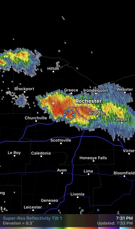
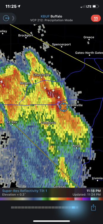
While the presence and placement of last nights storms was well forecasted, the intensity was a huge miss. Quite fascinating to see an event like this occur with very little advanced warning. The Hazardous Weather product called out Gusty Winds and heavy rain as the primary threat, and confidence seemed low from the verbiage in the discussions. We ended up with 60,000ft storms spitting golf ball size hail, winds gusting to 70mph, rain rates near 3-5"/hr, and continuous cloud to ground lightning for well over an hour in some locations. It's kind of fun to know that a storm can still catch us almost completely off-guard. We had the best snowstorm of the year the second week of November. We had nice Spring weather in March. And we just saw the most intense thunderstorms that we'll see all summer and potentially for several years happen the first week of June. We've really blown our loads early these last few seasons. -

Upstate/Eastern New York
DeltaT13 replied to BuffaloWeather's topic in Upstate New York/Pennsylvania
Round 2 is charging across Michigan and on schedule to hit buffalo again around 8-9am. We’ll see what happens as diurnal effects usually weaken and turn these systems sharply south. Could be a hell of a 12 hour window of storms though. -

Upstate/Eastern New York
DeltaT13 replied to BuffaloWeather's topic in Upstate New York/Pennsylvania
Lot of really interesting things in that loop. Notice how that first big cell that hits Niagara county turns a bit right and really dives straight south into the more unstable downstream air. Nocturnal storms are definitely WNY’s best chance at severe weather. -

Upstate/Eastern New York
DeltaT13 replied to BuffaloWeather's topic in Upstate New York/Pennsylvania
I just chased it and nearly got more than I bargained for. I was able to cut off this cell. Next thing you know I was in one of the strongest hail cores I’ve seen around here in awhile. I think I sustained a few dents and chipped windshield. Daylight will tell. It went from whoa fun to holy shit really fast. Haha. Super powerful storm though. Absolutely continuous lightning. -

Upstate/Eastern New York
DeltaT13 replied to BuffaloWeather's topic in Upstate New York/Pennsylvania
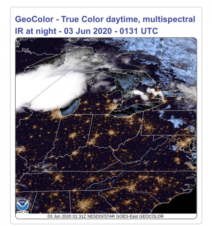
I can see the top of that storm from my patio. The lightning is absolutely continuous from this vantage. Just amazing. I can even see cloud structure. I’m 50 miles away! -

Upstate/Eastern New York
DeltaT13 replied to BuffaloWeather's topic in Upstate New York/Pennsylvania
I saw some 65dbz returns packed with cloud to ground lighting strikes so I figured there must be a nasty hail core in there. That seems quite unusual for a nocturnal MCS -

Upstate/Eastern New York
DeltaT13 replied to BuffaloWeather's topic in Upstate New York/Pennsylvania
Those storms are building beautifully and packed with lightning. Wish I could chase em. -

Upstate/Eastern New York
DeltaT13 replied to BuffaloWeather's topic in Upstate New York/Pennsylvania
-

Upstate/Eastern New York
DeltaT13 replied to BuffaloWeather's topic in Upstate New York/Pennsylvania
Yup! Pretty fun to watch. Looks like buffalo is lining up to get clobbered right now and Rochester is going to be too far east. I hate missing out on these events, they are so rare around here. The most intense lightning storms I’ve ever seen around here are always MCS’s. Buckle up buffalo, it’s looking promising for you guys -

Upstate NY Banter and General Discussion..
DeltaT13 replied to wolfie09's topic in Upstate New York/Pennsylvania
This will be a major point of conversation for sure. -

Upstate NY Banter and General Discussion..
DeltaT13 replied to wolfie09's topic in Upstate New York/Pennsylvania
I think outdoor transmission is minimal at best. Hence why spring break didn’t cause a spike and the reopening protests in Michigan didnt cause a spike. -

Upstate/Eastern New York
DeltaT13 replied to BuffaloWeather's topic in Upstate New York/Pennsylvania
The first one is somewhat developing right now north and northwest of Lake Ontario. Parts of it are already moving through Rochester. It’s definitely diffuse and disorganized right now. The 18z nam has it exploding in the next hour or so. Looks potent but it’s the nam -

Upstate/Eastern New York
DeltaT13 replied to BuffaloWeather's topic in Upstate New York/Pennsylvania
Some rather strong storms firing up under this extremely cold airmass. Wouldn’t be surprised to see some hail with the freezing level so low. Would be harmful to the fragile new veggie gardens. Rochester had some rain but just cleared out so the atmosphere is ripe. Seems like several rounds of intense pulse storms will be on tap. . -

Upstate/Eastern New York
DeltaT13 replied to BuffaloWeather's topic in Upstate New York/Pennsylvania
I want arctic cold in winter and searing heat in summer. I need the extremes. I’m digging out the hoodies and cold weather gear for the next few days. I hate it after that glorious taste of summer. -

Upstate/Eastern New York
DeltaT13 replied to BuffaloWeather's topic in Upstate New York/Pennsylvania
Certainly some potential. The more sun we can get the better. The prefrontal cells on the high res models look better than the actual frontal squall line. The Niagara frontier over to ROC will likely be shadowed as usual -

Upstate/Eastern New York
DeltaT13 replied to BuffaloWeather's topic in Upstate New York/Pennsylvania
Crazy to see the 530dm line dipping into NY early next week. High peaks will probably see a couple flakes and a final hard freeze. -

Upstate/Eastern New York
DeltaT13 replied to BuffaloWeather's topic in Upstate New York/Pennsylvania
It’s 75 degrees at 11pm. Where did this one from?! Absolutely amazing night around the fire.


