-
Posts
3,006 -
Joined
-
Last visited
Content Type
Profiles
Blogs
Forums
American Weather
Media Demo
Store
Gallery
Everything posted by DeltaT13
-
Upstate/Eastern New York
DeltaT13 replied to BuffaloWeather's topic in Upstate New York/Pennsylvania
The new radar site from the NWS is hot garbage. I had been fearing this upgrade. It's such a dumbed down product now. Give me raw ****ing radar data damnit -

Dec 16-17 Storm OBS Thread
DeltaT13 replied to BuffaloWeather's topic in Upstate New York/Pennsylvania
To keep our petty battle going, you did say that at some point, but then you went on to say You also, threw around these statements yesterday. "Noticed meso models give roc 6 to 8 inches with lake effect" "Gives roc 6 inches" "6 in roc more upside spread" "Gived roc over 7 inches" "Ukmet hammers roc with the lake snow" So if you would have just stuck with your first call, I'd say you did alright. But you hyped and hyped and here we are, with 2 inches. Sorry dude, it is what it is. -

Dec 16-17 Storm OBS Thread
DeltaT13 replied to BuffaloWeather's topic in Upstate New York/Pennsylvania
Check out the latest visible satellite of the storm spinning off the coast, pretty compact and tight little storm now! https://www.star.nesdis.noaa.gov/GOES/sector_band.php?sat=G16§or=ne&band=GEOCOLOR&length=24 -

Dec 16-17 Storm OBS Thread
DeltaT13 replied to BuffaloWeather's topic in Upstate New York/Pennsylvania
I heard him call for 4-8 for Rochester many times, with a possible 3-5 of additional lake effect (of which we got zero) I'm not getting carried with any compliments on this one. -

Dec 16-17 Storm OBS Thread
DeltaT13 replied to BuffaloWeather's topic in Upstate New York/Pennsylvania
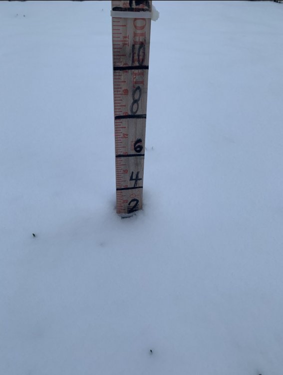
Snow on the ground stake I only posted this sad pic because we are going to scrutinize the KROC numbers this season. -

Dec 16-17 Storm OBS Thread
DeltaT13 replied to BuffaloWeather's topic in Upstate New York/Pennsylvania
That’s true, an isolated location or two in each snowbelt is the only place even in the realm of those numbers. -

Dec 16-17 Storm OBS Thread
DeltaT13 replied to BuffaloWeather's topic in Upstate New York/Pennsylvania
Just took my last measurement at 8am. I had .8” at 7pm last night and just measured another 1.25 at 8am after 13 hours. Not accounting for compacting (which was likely minimal), we got about 2 inches on the button. -

Dec 16-17 Storm OBS Thread
DeltaT13 replied to BuffaloWeather's topic in Upstate New York/Pennsylvania
I cannot believe it! Honestly one of the heaviest snow events I’ve ever seen around here. Never thought I’d see a kuchera map verify or even miss low. -

Dec 16-17 Storm OBS Thread
DeltaT13 replied to BuffaloWeather's topic in Upstate New York/Pennsylvania
Aside from the Tug, I think Binghamton just broke every “24 hour” snowfall record in the state. Those numbers are jaw dropping. The first flakes didn’t fly there until around 130pm. So 40 inches in about 17 hours. My mind is blown. -

Dec 16-17 Storm OBS Thread
DeltaT13 replied to BuffaloWeather's topic in Upstate New York/Pennsylvania
Dude. Come on. Snow blowing is one of my favorite things in the world as a winter weather nut. -

Dec 16-17 Storm OBS Thread
DeltaT13 replied to BuffaloWeather's topic in Upstate New York/Pennsylvania
I’ll tell you one thing, that 1.75” of snow has made the roads pretty damn treacherous. I think that very cold dry overnight period really primed the ground to hold the snow. -

Dec 16-17 Storm OBS Thread
DeltaT13 replied to BuffaloWeather's topic in Upstate New York/Pennsylvania
Yeah I can’t explain that banding but it looks intense. Poor kbuf can’t catch a break. The heaviest snow in their entire CWA right now is over the 3 counties that don’t have an advisory. SMH -

Upstate NY Banter and General Discussion..
DeltaT13 replied to wolfie09's topic in Upstate New York/Pennsylvania
I’m aware you don’t value life and specially the lives of others. We’ve been down this road before. Thankfully not everyone thinks like you. -

Dec 16-17 Storm OBS Thread
DeltaT13 replied to BuffaloWeather's topic in Upstate New York/Pennsylvania
Oh that was me and several others. You have to be patient on these transfers. -

Dec 16-17 Storm OBS Thread
DeltaT13 replied to BuffaloWeather's topic in Upstate New York/Pennsylvania
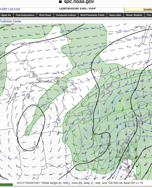
Upper levels are still Intriguing. The OG 700mb low is still closed off and intact over Michigan, while the new 700mb low is forming over southwestern PA. This is quite a bit further west than i thought it would form. -

Dec 16-17 Storm OBS Thread
DeltaT13 replied to BuffaloWeather's topic in Upstate New York/Pennsylvania
Wait, what did I say?! -

Dec 16-17 Storm OBS Thread
DeltaT13 replied to BuffaloWeather's topic in Upstate New York/Pennsylvania
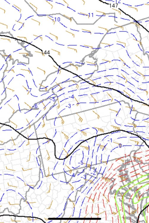
Probably not just yet. 850s are southeasterly still. 925mb is due easterly and must be responsible for that tiny ribbon of lake effect just north of Niagara county (which must be obscenely shallow). Needless to say, tons of shear in the atmosphere right now. Enhancement should ramp up late night as the storm consolidates and the winds line up from the NE 850 925 -

Dec 16-17 Storm OBS Thread
DeltaT13 replied to BuffaloWeather's topic in Upstate New York/Pennsylvania
I cleared .8” off the snowboard at 7pm. I’ll probably let it run 12 hours and check again at 7am fun fact - on my way into the backyard I slipped on frozen ground and busted my ass so bad. It was like a cartoon fall. It’s a shame no one was there to laugh at me. I haven’t gone down like that in a long time. -

Dec 16-17 Storm OBS Thread
DeltaT13 replied to BuffaloWeather's topic in Upstate New York/Pennsylvania
Our bonus wave of snow is winding down, we really werent even supposed to get it so no worries about it drying up. The main plume from the secondary is when we'll hopefully pick up a couple inches during the overnight hours. Sad that I'll be sleeping through most of that... -

Dec 16-17 Storm OBS Thread
DeltaT13 replied to BuffaloWeather's topic in Upstate New York/Pennsylvania
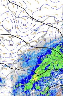
I didnt think we would see green radar returns up this way at any point during this storm so this is certainly unexpected. -

Dec 16-17 Storm OBS Thread
DeltaT13 replied to BuffaloWeather's topic in Upstate New York/Pennsylvania
-

Dec 16-17 Storm OBS Thread
DeltaT13 replied to BuffaloWeather's topic in Upstate New York/Pennsylvania
From what I can tell, our best chances for snow come when the secondary really takes over and pushes a big plume of moisture North as the Mid levels close off. I wouldnt be counting on the scraps from the primary to give us anything appreciable. -

Dec 16-17 Storm OBS Thread
DeltaT13 replied to BuffaloWeather's topic in Upstate New York/Pennsylvania
I would say you are about 90 minutes ahead of schedule not 8 hours. Still a good sign that things are moistening up nicely! -

Dec 16-17 Storm OBS Thread
DeltaT13 replied to BuffaloWeather's topic in Upstate New York/Pennsylvania
Thats the primary 700mb low which will soon fizzle away. We are interested in when the secondary low can close off at 700mb and thats still many hours away -

Dec 16-17 Storm OBS Thread
DeltaT13 replied to BuffaloWeather's topic in Upstate New York/Pennsylvania


