-
Posts
3,006 -
Joined
-
Last visited
Content Type
Profiles
Blogs
Forums
American Weather
Media Demo
Store
Gallery
Everything posted by DeltaT13
-
Upstate/Eastern New York
DeltaT13 replied to BuffaloWeather's topic in Upstate New York/Pennsylvania
The models are doing well for both this storm and the last storm in my opinion. The issue is that us super weather nerds are expecting a resolution that just doesn’t exist. This storm has been more or less nailed down to less than 100 miles of variation for nearly 6 days. It’s pretty phenomenal. We just happen to care about subtle nuances where 10 or 20 miles shifts the axis over someone else’s backyard on this forum.... Sure a sliver of people in every storm may not get exactly what they expected but overall this storm has been locked for days and days on a large scale. I think the models are doing alright. -

Major LES event-December 24-27
DeltaT13 replied to BuffaloWeather's topic in Upstate New York/Pennsylvania
You of all people should understand this difficulty in this scenario. You have access to every piece of data that they do. What's your call then?? -

Upstate/Eastern New York
DeltaT13 replied to BuffaloWeather's topic in Upstate New York/Pennsylvania
I mean 4 inches would be our biggest "storm" of the year, lol. Desperate times man..... -

Upstate/Eastern New York
DeltaT13 replied to BuffaloWeather's topic in Upstate New York/Pennsylvania
ONLY?? We've been on the brink of getting skunked for several days. 4 inches would be AMAZING. The trend is good. Stay on the right side of this battle man! -

Upstate/Eastern New York
DeltaT13 replied to BuffaloWeather's topic in Upstate New York/Pennsylvania
3k NAM never does well with the precip shields. I can think of many times this summer when it showed a scraggly precip field or frontal passage only for us to get completely crushed with heavy rain that looked nothing like the 3k depiction. You're better off looking at the 12k model which does a better job of smoothing and averaging the precip IMO. -

Upstate/Eastern New York
DeltaT13 replied to BuffaloWeather's topic in Upstate New York/Pennsylvania
It's acquired taste and what you end up with after living in WNY for 40 years and never once living in an actual snowbelt. You learn to enjoy what you get. -

Upstate/Eastern New York
DeltaT13 replied to BuffaloWeather's topic in Upstate New York/Pennsylvania
lolz, some of these models are silly. There won't be any noticeable freezing rain with a fast transient system like this IMO -

Upstate/Eastern New York
DeltaT13 replied to BuffaloWeather's topic in Upstate New York/Pennsylvania
That sounds like a wonderful consolation prize to me. If it wouldnt be white, I'll take windy any day of the week! -

Major LES event-December 24-27
DeltaT13 replied to BuffaloWeather's topic in Upstate New York/Pennsylvania
Not sure how long it stays in any one place, but that thing is going to paste some people with a quick blast of snow if the 3kNAM comes through. -

Upstate/Eastern New York
DeltaT13 replied to BuffaloWeather's topic in Upstate New York/Pennsylvania
Meso Models say go buy some white paint if you want a white Christmas in Rochester or anywhere East. Not a god damn flake to be had. I knew it would be bad, but I didn't think it would be this bad. The wife is trying to kibosh my Christmas day chase too! Normally she would be into it, but she just wants to be lazy on Christmas and I really can't blame her. arrgggggggg -

Upstate/Eastern New York
DeltaT13 replied to BuffaloWeather's topic in Upstate New York/Pennsylvania
-

Upstate/Eastern New York
DeltaT13 replied to BuffaloWeather's topic in Upstate New York/Pennsylvania
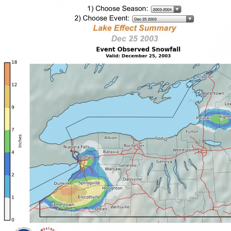
I’ll always remember Christmas Day 2003, a pretty strong band was hitting the northern suburbs and airport....which would have been awesome except I was flying to Hawaii that morning. The only time in my entire life that I was cursing a beautiful full length Erie band. It was painful. Thankfully the flight took off with only a minor delay. A little scary taking off in heavy snow like that though. Looks like the airport had 8.2 with that event but local suburbs might have had more. -

Upstate NY Banter and General Discussion..
DeltaT13 replied to wolfie09's topic in Upstate New York/Pennsylvania
So just to summarize your post...you consider yourself smarter and more informed than the thousands of scientists and doctors that created this vaccine, is that correct? If that isnt the case, you feel as if this is some huge covert conspiracy theory, of which you are the only person to uncover this, is that correct? Either way we spin it, you are apparently a foremost virus expert or the greatest detective of our time. Get over yourself. Also, you personify the viruses behavior as if its a thinking sentient creature hell bent on the destruction of the human race. It's not checking its copies, its not scanning its makeup. It's a ****ing primitive virus mutating and surviving at a base level. Stop glorifying it. -

Upstate/Eastern New York
DeltaT13 replied to BuffaloWeather's topic in Upstate New York/Pennsylvania
Can anyone actually get it to load? It completely fails on my mobile and once in awhile i can get a couple frames to somewhat load on a desktop but overall I don't think I've seen a full loop work once yet. How can people be ok with this? Am I doing something wrong? -

Upstate/Eastern New York
DeltaT13 replied to BuffaloWeather's topic in Upstate New York/Pennsylvania
Im hoping to chase this in Genesee or SE Orleans county so I don’t have to drive too far. Sometimes the band is quite intense near Batavia as it pops from a little orographic lift....but that will require the remnant low and subsequent thermal trough to be especially deep to give me a true SW flow. Nothing written in stone with such subtle nuances still not locked down. Wyoming county is my backup chase, would probably head down 19. -

Upstate/Eastern New York
DeltaT13 replied to BuffaloWeather's topic in Upstate New York/Pennsylvania
The only reason this got posted so far in advance is because it hits on Christmas Day. That’s not the kind of surprise you want on a fairly busy travel period. A lot of implications during a holiday. -

Upstate/Eastern New York
DeltaT13 replied to BuffaloWeather's topic in Upstate New York/Pennsylvania
In due time. Area wide will see a few to several inches. Probably 2-5 in the best case scenario. There is no need for them to address that in any more depth when things are still very uncertain synoptically 4 days out; and 2-5 inches of snow should be handled without headlines or fanfare around here if we are to have any sort of pride. Lol -

Upstate/Eastern New York
DeltaT13 replied to BuffaloWeather's topic in Upstate New York/Pennsylvania
Agree 100% on this. Cold and snow cover is all I want on Christmas day. We've had some warm green ones over the last decade and it sucks. -

Upstate/Eastern New York
DeltaT13 replied to BuffaloWeather's topic in Upstate New York/Pennsylvania
Unless youre in a prime lake effect location, I'm not really banking on impressive snowfall totals with this Christmas system. The pace of this thing is just unreal, especially if the GFS type scenario played out. I can't imagine we could get more than an inch or two of snow before the precip tapers off, BUT at least it would be a white Christmas!! As for the lake effect, that certainly looks prime but somewhat short lived with modest warm air advection starting by Saturday afternoon. That said, with 2-3" an hour rates, 24-36 hours will more than enough time for some very hefty totals. I'm considering driving into Buffalo to Chase a bit on Christmas seeing as I won't be visiting anyone for this year That will be a game time call but it's definitely on my radar! In Summary, unless you're in one of those key lake effect spots, don't get your hopes up for a big dump. Just not a good synoptic setup. -

Upstate/Eastern New York
DeltaT13 replied to BuffaloWeather's topic in Upstate New York/Pennsylvania
interesting. We had about a half inch of snow down here. It’s turned to a super slop layer now though as temps have finally started to climb a bit. Up to 34-35 whereas I sat at 32.5 all night. Missed out on a nice little refresher by a degree -

Upstate/Eastern New York
DeltaT13 replied to BuffaloWeather's topic in Upstate New York/Pennsylvania
That new Buffalo radar is even worse than I thought. It literally will not even load. How in the hell is that the finished “upgraded” product?! It’s mind boggling. -

Upstate/Eastern New York
DeltaT13 replied to BuffaloWeather's topic in Upstate New York/Pennsylvania
I'm all about what happens after the front, but that wave development just seems nearly implausible, very rare to see a low develop that quickly and deeply while racing up a front. The timing would have to be impeccable, and even then, the snow would move in and out at break neck speed. But you know what, we have something to track and hang our christmas hopes on, so for that I am grateful. -

Upstate/Eastern New York
DeltaT13 replied to BuffaloWeather's topic in Upstate New York/Pennsylvania
I think we get the christmas eve cold front, that seems fairly locked in. But chasing a wave that develops along the front 7 days out is a long shot. Very tricky evolution for that to work out. -

Upstate/Eastern New York
DeltaT13 replied to BuffaloWeather's topic in Upstate New York/Pennsylvania
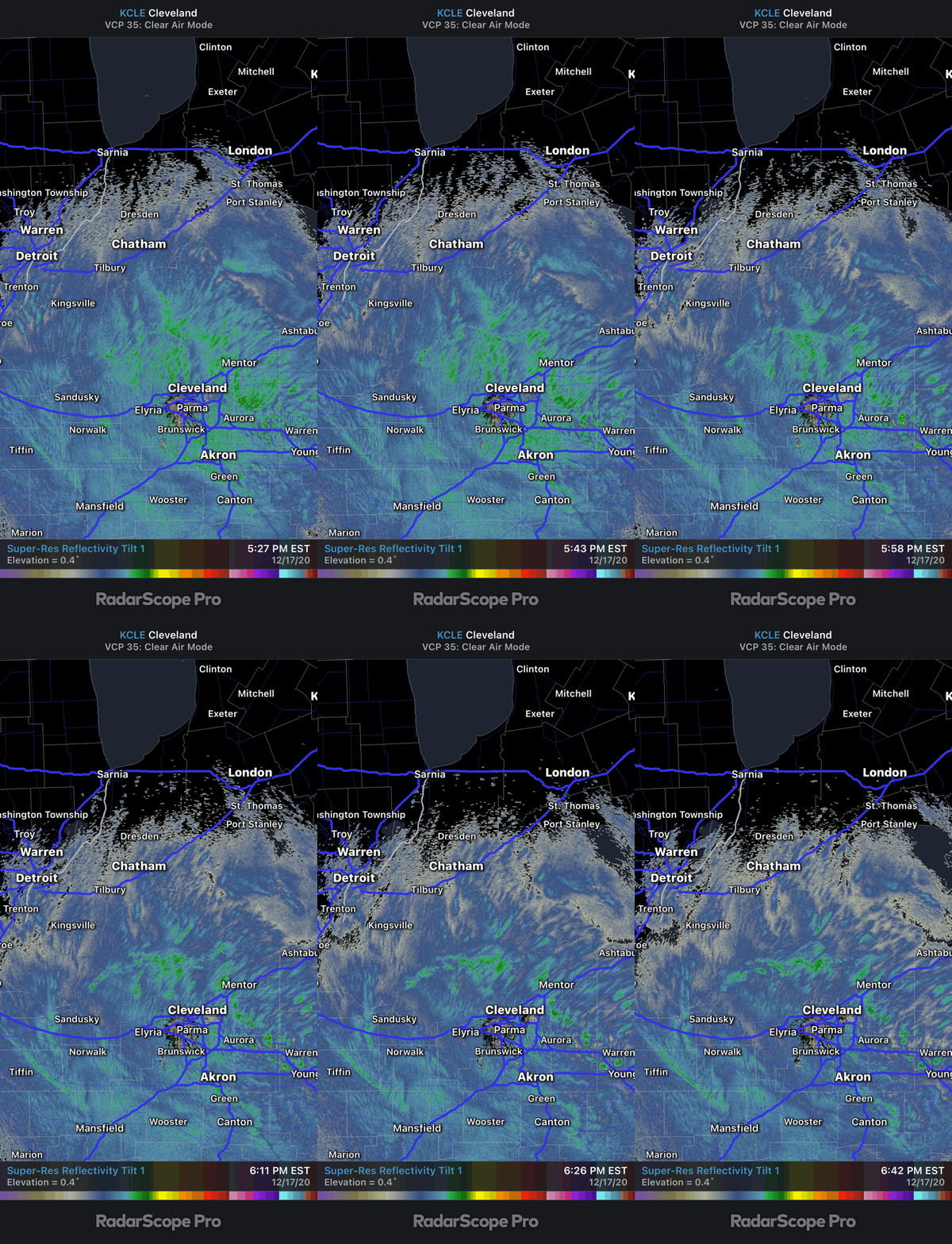
Really cool radar this evening showing low level lake effect moving east to west while light synoptic snow is moving south to north in the mid levels. -

Upstate/Eastern New York
DeltaT13 replied to BuffaloWeather's topic in Upstate New York/Pennsylvania


