-
Posts
3,006 -
Joined
-
Last visited
Content Type
Profiles
Blogs
Forums
American Weather
Media Demo
Store
Gallery
Everything posted by DeltaT13
-
Upstate/Eastern New York
DeltaT13 replied to BuffaloWeather's topic in Upstate New York/Pennsylvania
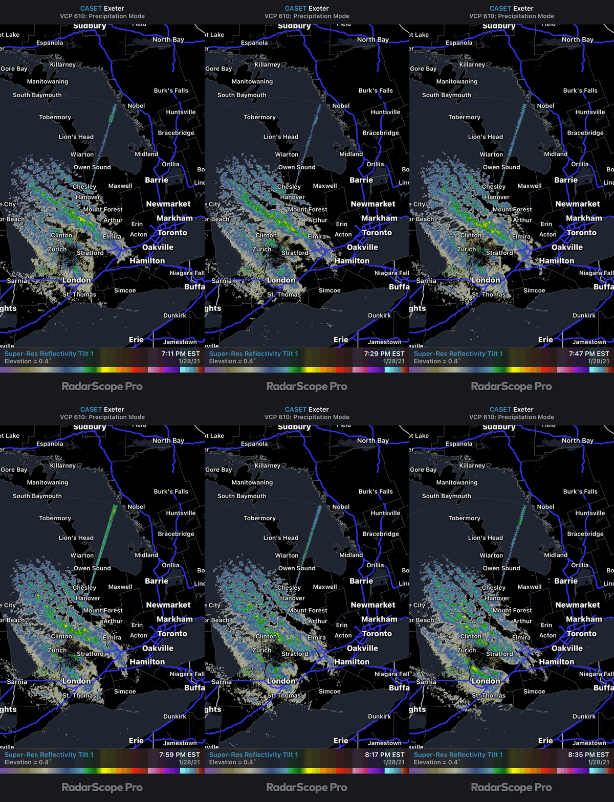
This lake effect so far tonight seems to favor the inland locations where there is better convergence and a little orographic pop. Not too unexpected but a little disappointing for me over here..... Still about 9-12 hours of optimal thermal profiles and some blobs of synoptic moisture coming though. You can see a thermal trough over lake Ontario in this Image. Also fairly well aligned winds across Lake Ontario. I think we lose the GB connection for awhile. Lots to track but I slept like shit last night so maybe be cashing in soon. -

Upstate/Eastern New York
DeltaT13 replied to BuffaloWeather's topic in Upstate New York/Pennsylvania
It's like 10 bucks a year for the best radar data in the country. So many features too. Bite the bullet man, you had a banner year in the market! -

Upstate/Eastern New York
DeltaT13 replied to BuffaloWeather's topic in Upstate New York/Pennsylvania
https://weather.cod.edu/satrad/nexrad/?parms=BUF-N0Q-1-24-100 -

Upstate/Eastern New York
DeltaT13 replied to BuffaloWeather's topic in Upstate New York/Pennsylvania
I’m guessing it’s a wind thing. The radar beam is hitting that band relatively high over that location and the wind is probably displacing that snow a mile or so east of the heaviest returns at the surface -

Upstate/Eastern New York
DeltaT13 replied to BuffaloWeather's topic in Upstate New York/Pennsylvania
There is some snow in the air. The radar is filling in pretty nicely though. Hoping we can get some added lift from upper low. Over on Huron they are getting pounded pretty good. That has to be one of the better places to live for lake effect snow in the Great Lakes. Also interesting that the bands have been moving around quite a bit already. The Georgian bay band has reoriented itself about 3 times since late afternoon. And that Huron band is on the move too. -

Upstate/Eastern New York
DeltaT13 replied to BuffaloWeather's topic in Upstate New York/Pennsylvania
Coastal transfers are a sore subject around here, at least for me. I've definitely seen some big busts from them over the years. To have a shot, we need this thing further North IMO, heading towards Cleveland before the transfer starts to initiate. The remnant inverted trough can work out, but again thats never set in stone. Still a very long ways off so we shouldnt be latching onto anything just yet. I'm just glad it isnt cutting on us. I'd rather get no snow than have this thing cut and give us rain, obviously. -

Upstate/Eastern New York
DeltaT13 replied to BuffaloWeather's topic in Upstate New York/Pennsylvania
You can see our main player for tonight on the visible satellite as it spins its way down through Western Quebec. Quite the chunk of cold air and vorticity. Look quick before the sun sets! https://www.star.nesdis.noaa.gov/GOES/sector_band.php?sat=G16§or=ne&band=GEOCOLOR&length=24 -

Upstate/Eastern New York
DeltaT13 replied to BuffaloWeather's topic in Upstate New York/Pennsylvania
If we were going to get 80's for a few days I would be all about that. I'm all about the extremes. 40's and rain is useless. But 80's in February is so damn novel that I would gladly take that over some snow. Could probably have a crazy ass day on the slopes if something like that ever happened too. -

Upstate/Eastern New York
DeltaT13 replied to BuffaloWeather's topic in Upstate New York/Pennsylvania
That King City radar is a piece of shit, I'm not sure why that is. Anyway, this IR satellite shows winds coming around and cloud tops are cooling along the entire south shore, especially where there is upstream seeding. https://weather.cod.edu/satrad/?parms=local-LakeOntario-13-48-1-100 -

Upstate/Eastern New York
DeltaT13 replied to BuffaloWeather's topic in Upstate New York/Pennsylvania
Those are the anomalies. 850's will be around 5c...which still sucks but obviously not as bad........20c would be full blown summer weather! -

Upstate/Eastern New York
DeltaT13 replied to BuffaloWeather's topic in Upstate New York/Pennsylvania
You know id be chasing that one! That 6z gfs was a beaut for LES. -

Upstate/Eastern New York
DeltaT13 replied to BuffaloWeather's topic in Upstate New York/Pennsylvania
I’ve always been in the camp that high ratio lake snow isn’t really the same as getting “real snow”. I know it’s crazy but give me 3 inches of 8:1 over 18 inches of 30:1 any day of the week. It’s all about quality over quantity in my book. I got an inch last night but am hesitant to even put it my log, i can compress it down to less than a tenth of an inch. As someone who is all about snowpack, this stuff doesn’t help much. But I do absolutely enjoy the winter aspect of snow in the air and snow coming down so I’m certainly excited for the next 24 hours. -

Upstate/Eastern New York
DeltaT13 replied to BuffaloWeather's topic in Upstate New York/Pennsylvania
It’s all about GB for me, I need that extra boost. I just wish it would lock it for one but it’s usually on the move. -

Upstate/Eastern New York
DeltaT13 replied to BuffaloWeather's topic in Upstate New York/Pennsylvania
Perfect snow to take a Jeb walk tonight, but you gotta bundle up! Id probably have to do some chasing to get into the good stuff and a Thursday night isn’t the most ideal time. -

Upstate/Eastern New York
DeltaT13 replied to BuffaloWeather's topic in Upstate New York/Pennsylvania
It certainly can happen but these transfer situations usually shunt those heavier bands downstate. In the big event downstate this winter (BGM 41"), the parent low seemed to hang on longer than forecast which allowed that conveyor to setup further North and West than normal. There was also a major blocking pattern in that storm which forced the precip shield to hit a wall. Anyway, it can definitely happen but favors places further East IMO. I also would be cautious about the end of that run when the low is jumping around as it sits and spins. It rarely hangs around that long in reality and the variability of where it finally stalls could make or break us. We need heavy snow on the front end from the primary low. All that said, the 0z GFS was a huge step in the right direction, but some might say its happening too soon, lolz. -

Upstate/Eastern New York
DeltaT13 replied to BuffaloWeather's topic in Upstate New York/Pennsylvania
I hate Mexico Bay convergence because I always feel like they do well on Westerly winds and then somehow also do well in NW regimes too. So f-ing greedy. Share the wealth. No, I see it though, its nice the models are picking it up. I need a GB connection to really be in the game and those are so damn transient... -

Upstate/Eastern New York
DeltaT13 replied to BuffaloWeather's topic in Upstate New York/Pennsylvania
Do you mean in the latest run when the low is stalling over NYC? -

Upstate/Eastern New York
DeltaT13 replied to BuffaloWeather's topic in Upstate New York/Pennsylvania
I think Wayne County is definitely the sweet spot for Friday. The radar is going to miss a lot of it so we'll need some obs from the ground. -

Upstate/Eastern New York
DeltaT13 replied to BuffaloWeather's topic in Upstate New York/Pennsylvania
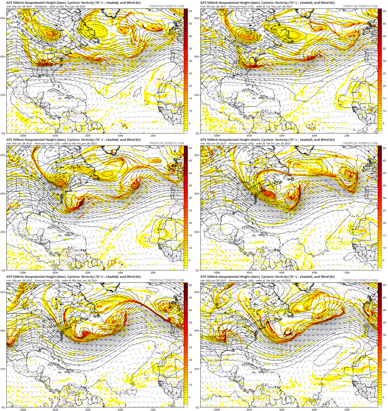
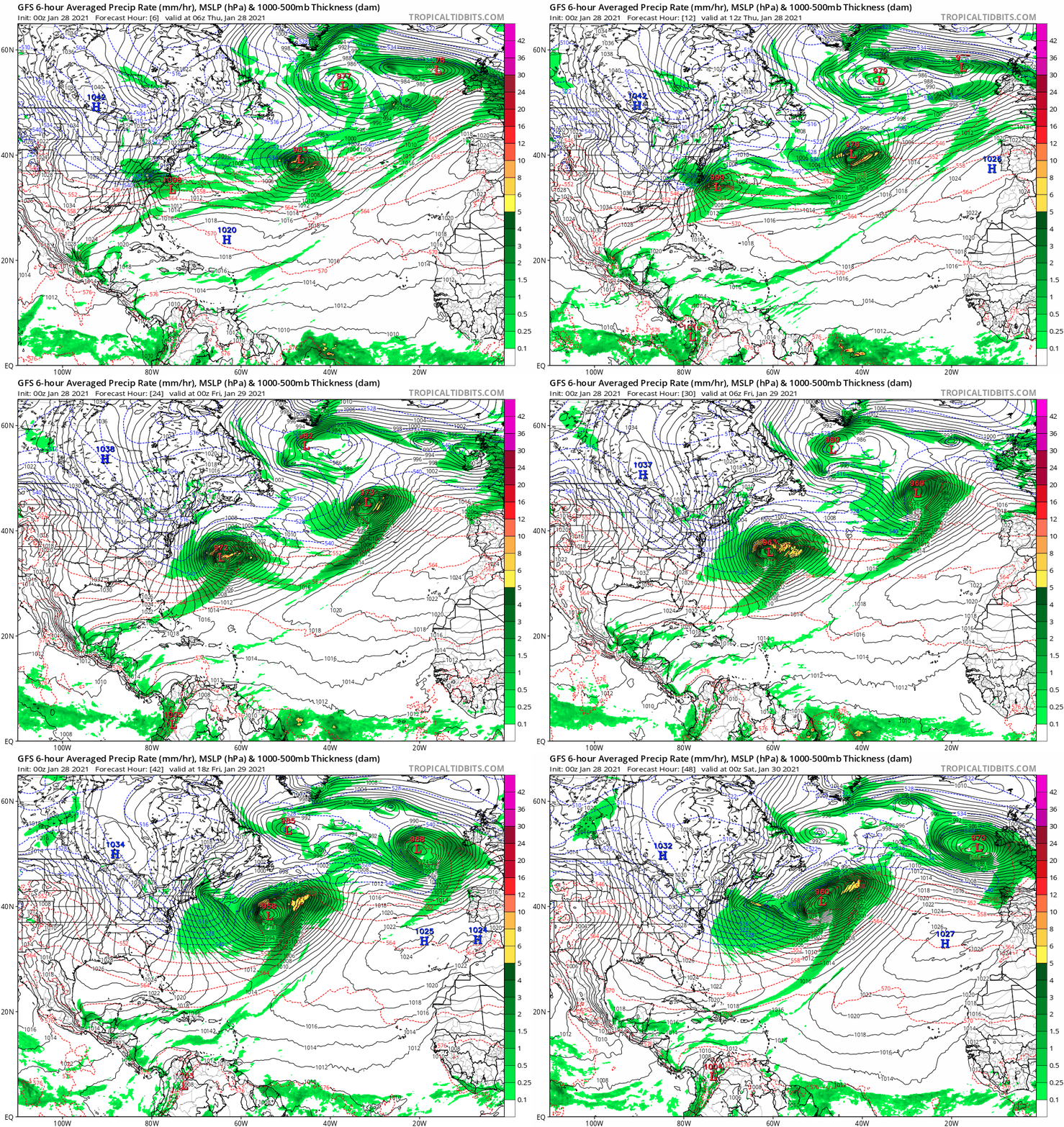
Look at how close the East Coast came to a truly massive storm today/tomorrow. That low that is forming over NC right now explodes to 958mb in 30 hours, spurred on by that huge chunk of arctic air dropping out of Eastern Canada (and it's not even a clean phase). The 500mb low is a thing of beauty as it dives through the Northeast. If only it had phased just 500 further West..... -

Upstate/Eastern New York
DeltaT13 replied to BuffaloWeather's topic in Upstate New York/Pennsylvania
As for the upcoming lake effect potential, there is only one 12 hour period with a vertical profile that I think looks conducive to fairly deep pseudo organized lake effect. That time is from 12am Friday until noon Friday. I'm definitely rusty on skewT's but I think in this scenario, we take the lake temp as the starting point for the surface air temp and then ride up the moist adiabat until we hit the ambient air temp (I think we assume that the air over the lake is saturated so we don't have to use saturation mixing ratio line?). So starting around 5c gives us a pretty deep column. Most importantly though is that the atmosphere is saturated up through 700mb which gives us a lot of background moisture to work with. After noon on Friday the profiles start to degrade pretty quickly By Friday night the inversion is crashing down hard. -

Upstate/Eastern New York
DeltaT13 replied to BuffaloWeather's topic in Upstate New York/Pennsylvania
That entire snow growth region on the skew T is in bone dry air so I don't think snow is forming in that layer. Its happening in that thin saturated layer below 850, right? -

Upstate/Eastern New York
DeltaT13 replied to BuffaloWeather's topic in Upstate New York/Pennsylvania
There will be so many fools holding that bag of shit in a couple weeks. Just don’t be the last one off that ride. -

Upstate/Eastern New York
DeltaT13 replied to BuffaloWeather's topic in Upstate New York/Pennsylvania
I mean I’m up on everything in this weird wild banner of a year. But definitely not as high as it could have been. I sold early and took profits only to watch things soar. I can’t really complain, but patience would have paid off big time. -

Upstate/Eastern New York
DeltaT13 replied to BuffaloWeather's topic in Upstate New York/Pennsylvania
If only I had diamond hands when I needed them. Made some pretty lousy trades over this last year -

Upstate/Eastern New York
DeltaT13 replied to BuffaloWeather's topic in Upstate New York/Pennsylvania
They are being realistic about the Lake effect potential on Friday as there is only a small window of good parameters for a select few (I'm expecting 1-2" IMBY.) The storm next week though still has a lot potential, so we shall stay optimistic and ride that ICON into the sunset!


