-
Posts
3,006 -
Joined
-
Last visited
Content Type
Profiles
Blogs
Forums
American Weather
Media Demo
Store
Gallery
Everything posted by DeltaT13
-
Synoptic Snowstorm 2/1-2/4
DeltaT13 replied to BuffaloWeather's topic in Upstate New York/Pennsylvania
Coastal transfers simply do not work for WNY. The sooner you accept this the easier it becomes. I give you credit though, you held out hope longer than most. Respect. -

Upstate/Eastern New York
DeltaT13 replied to BuffaloWeather's topic in Upstate New York/Pennsylvania
I'll be heading your way this weekend B dubs!! -

Synoptic Snowstorm 2/1-2/4
DeltaT13 replied to BuffaloWeather's topic in Upstate New York/Pennsylvania
I mean is no one at that office actually looking at the radar and what is happening. There has been heavy snow heading in our direction for 12 hours now and none has made it here yet. There is obviously impressive subsidence and dry air to contend with. Current radar is drying up as fast as it has been all morning. -

Synoptic Snowstorm 2/1-2/4
DeltaT13 replied to BuffaloWeather's topic in Upstate New York/Pennsylvania
I'll believe it when I see it. 7+ inches, give me a ****ing break. 1-2" on the high end. -

Synoptic Snowstorm 2/1-2/4
DeltaT13 replied to BuffaloWeather's topic in Upstate New York/Pennsylvania
You're right about the first part. If we were going to get snow, it was all coming late in the period..It was never supposed to be snowing for most of us right now. 0z GFS says tomorrow will be snowy and wintry all day (Noon is when the column really saturates), so we'll see. Might not be a ton of snow but I'll take anything at this point.. -

Synoptic Snowstorm 2/1-2/4
DeltaT13 replied to BuffaloWeather's topic in Upstate New York/Pennsylvania
Good lord. That must be 3-5”/hr stuff, epic! -

Synoptic Snowstorm 2/1-2/4
DeltaT13 replied to BuffaloWeather's topic in Upstate New York/Pennsylvania
NE lake enhancement is one of my favorite setups. I feel like big DeltaT's arent as critical with a lot of background moisture and lift. Those are right around the 13 degree benchmark though so we should be in play, perhaps doing a little better because the lake temp is probably 4 or 5 degrees above freezing for some portion of the center of it. -

Synoptic Snowstorm 2/1-2/4
DeltaT13 replied to BuffaloWeather's topic in Upstate New York/Pennsylvania
For a smaller mountain, their glades are really impressive. It always blows my mind when they have the snow how much terrain there is, and its pretty technical. I only go when I know I can get off piste though...and Wednesday looks pretty prime. -

Synoptic Snowstorm 2/1-2/4
DeltaT13 replied to BuffaloWeather's topic in Upstate New York/Pennsylvania
Yeah, he's all in. I'm on the West Side of Roc and bitter. I think this is a great storm system meteorologically, I'm just not impressed by the throwback scraps in these situations for us in far WNY..it rarely works out. Cuse is on the cusp of legit snows though. That said, this storm stalls for a lot longer than similar systems, so perhaps once its really closes off and matures it will be able to channel a lot of moisture back west. Then there is the question of whether or not a deformation band will setup somewhere this way along with the lake effect wildcard. I'm certainly tracking it and hopeful, but just not feeling really confident. Im planning to hit Greek Peak on Wednesday which should be a very solid day. They have great glades! -

Synoptic Snowstorm 2/1-2/4
DeltaT13 replied to BuffaloWeather's topic in Upstate New York/Pennsylvania
Buf - 3, ROC - 3, Syr - 5 -

Synoptic Snowstorm 2/1-2/4
DeltaT13 replied to BuffaloWeather's topic in Upstate New York/Pennsylvania
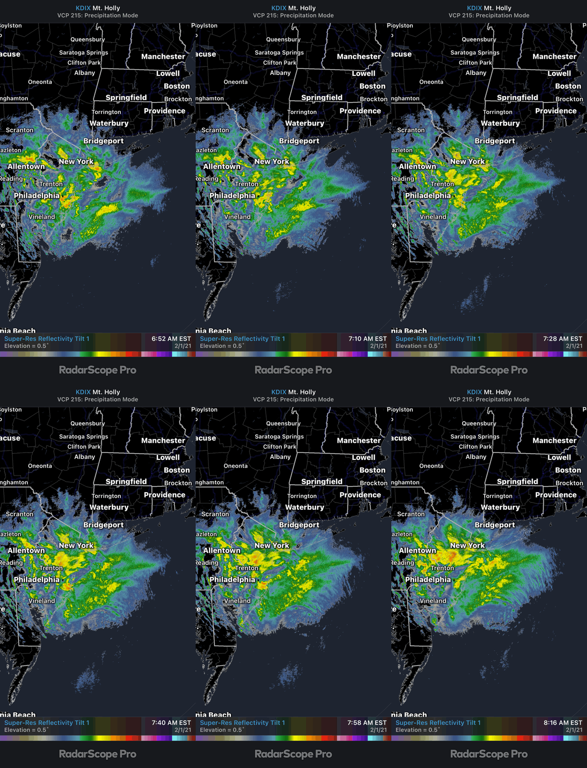
My forecast numbers for the I95 are going to miss by 2-3x, haha. They are getting blitzed right now. I guess I forgot what a stalled low with beautiful upper level dynamics can do on the coast in mid winter. Sadly, I think my upstate numbers will be more accurate -

Upstate/Eastern New York
DeltaT13 replied to BuffaloWeather's topic in Upstate New York/Pennsylvania
And its not even in fantasy land, quite intriguing. That's the Miller A we've been dreaming of. Frustratingly, that is the weekend of my annual Whiteface ski trip, that of course it's canceled this year. I will flip my shit if they get 3 feet of snow the first time I'm not there in the last decade. -

Upstate/Eastern New York
DeltaT13 replied to BuffaloWeather's topic in Upstate New York/Pennsylvania
You can clearly see the primary low off the NJ coast is now rapidly deepening (can see a swirl and fresh deep convection) We shall see if that contracts the precip field further west as things tighten up around the new low. -

Upstate/Eastern New York
DeltaT13 replied to BuffaloWeather's topic in Upstate New York/Pennsylvania
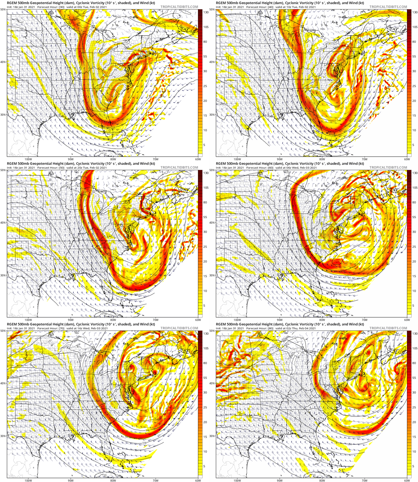
This storm is unique because a potent little shortwave (keep your eye on lower Michigan at hour 40) drops into the deepening trough right when the surface low is rapidly deepening. This extra little piece of energy actually rounds the entire base of the trough (closing off a few times) which really amplifies the entire system. That's definitely an interesting wildcard and why numerous lows are popping all over the place downstream. -

Upstate/Eastern New York
DeltaT13 replied to BuffaloWeather's topic in Upstate New York/Pennsylvania
RGEM was good for WNY and not as good for ENY. It's in the eye of the beholder when our forum spans so much real estate. -

Upstate/Eastern New York
DeltaT13 replied to BuffaloWeather's topic in Upstate New York/Pennsylvania
Was wondering the same thing. That RGEM is the first model Ive seen today that gave me pause and made me wonder if there is actually something to this storm (For KROC at least) -

Upstate/Eastern New York
DeltaT13 replied to BuffaloWeather's topic in Upstate New York/Pennsylvania
I'm thinking our snowpack survives that cutter and then the pattern after looks pretty decent. We've definitely gotten into a fairly fun cold pattern. -

Upstate/Eastern New York
DeltaT13 replied to BuffaloWeather's topic in Upstate New York/Pennsylvania
That’s the time period I was eying a week or so ago. We seem just a skosh away from a monster Miller A. I’d do anything for that. Would save the whole winter for me. -

Upstate/Eastern New York
DeltaT13 replied to BuffaloWeather's topic in Upstate New York/Pennsylvania
I’m more fascinated that it keeps the super cutter all snow for us later in that period. -

Upstate/Eastern New York
DeltaT13 replied to BuffaloWeather's topic in Upstate New York/Pennsylvania
I’m using a little hyperbole because that map was just ridiculous. Probably 2-3 inches here, probably from the secondary. I honestly don’t see it with a storm that far south and then that wrapped up on the coast. It’s just bad for us in far wny. Still a lot of this forum in play. Just not kROC -

Upstate/Eastern New York
DeltaT13 replied to BuffaloWeather's topic in Upstate New York/Pennsylvania
I’m amazed everyone remembers this one. It’s such a classic. We planned a snowmobiling weekend in the southern tier and expected a foot plus of snow. We got a few flurries. People were so confused, they kept thinking the storm was still coming...I was trying to tell them it was over. I was actually studying at Brockport at the time so we got to do a post mortem on it. It’s when I first learned about the tricky nature of the coastal transfer. I’ve never trusted them since. -

Upstate/Eastern New York
DeltaT13 replied to BuffaloWeather's topic in Upstate New York/Pennsylvania
We aren’t even getting 1.3” in solid form, lolol. Some of these maps are smoking that sticky icky this AM. -

Upstate/Eastern New York
DeltaT13 replied to BuffaloWeather's topic in Upstate New York/Pennsylvania
I wouldn’t even be tracking this dog of a storm if it wasn’t for you guys. So I’m grateful for you all keeping it positive around here. -

Upstate/Eastern New York
DeltaT13 replied to BuffaloWeather's topic in Upstate New York/Pennsylvania
We’ve barely had any wind storms this year. Huge disappointment on a year with very little snow too. Usually you can trade one for another, because cutters usually are at least wind producers. But this year it’s just benign weather for weeks on end. -

Upstate/Eastern New York
DeltaT13 replied to BuffaloWeather's topic in Upstate New York/Pennsylvania
It feels just like December 16. The precip shield will make a nice run up this way but just run out of juice on our doorstep. Then the secondary will strip it all way, only to throw it all back but it won't get past Syracuse. Same as it ever was.


