

DeltaT13
-
Posts
3,006 -
Joined
-
Last visited
Content Type
Profiles
Blogs
Forums
American Weather
Media Demo
Store
Gallery
Posts posted by DeltaT13
-
-
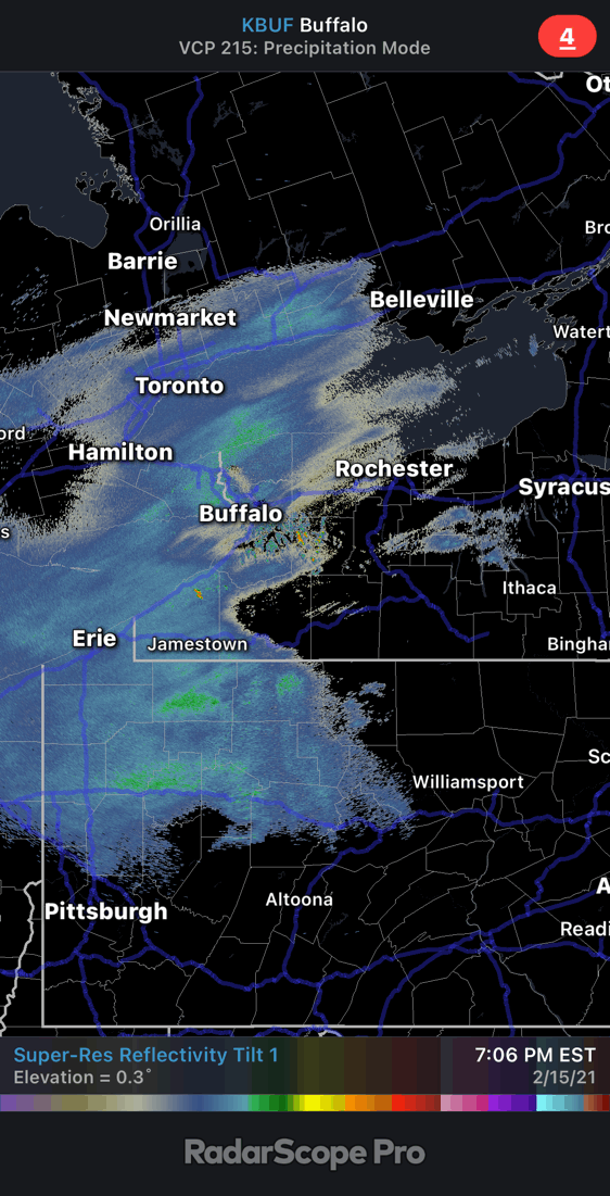
4 minutes ago, lakeeffectkid383 said:
As Delta mentioned I don’t think it’s a dry slot, if you look SW of Cleveland there is more precip streaming to the NE however it’s definitely a sizable patch of dry air that was not modeled at all and will put another dent in the totals to go along with the poor flake size.
Some of the high Res models this morning and at noon showed something similar. Just a little swirl or dry air and no forcing. Seems like it should fill in and be transient as it approaches WNY.
12z NAM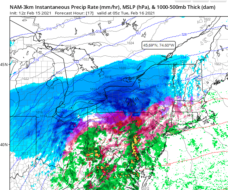
-
 1
1
-
-
33 minutes ago, rochesterdave said:
Can we not sweat the dry slot when it’s still in Kentucky? Lol. We have Hours and hours of heavy snow between now and then. I’m gonna try to enjoy it!

Furthermore, I don't even think that is the dry slot seeing as the Surface Low is south of it in Eastern TN. That's just a ragged precip shield that should fill in nicely in the hours to come. The dry slot hasn't really even developed yet.
-
 3
3
-
-
2 minutes ago, BGM Blizzard said:
Just stepped outside. All freezing rain. Already have a glaze on the pavement. F***kkk!
Wow. That’s brutal. Now the question is how much ice are you going to get? Could go from disappointing to downright dangerous.
-
You guys aren’t kidding about Chicago. What a fantastic seeder feeder double whammy of synoptic and pure lake effect. That would be so intense. And over a massive metro area. Reed timmer should have chased that one.

-
3
-
-
Well I’m looking around in central Pa and it looks like a lot of icing so that probably is a mix line. Unfortunate for the southern tier. But I feel pretty safe up here at least for 95 percent of the night.
-
2
-
-
Just now, lakeeffectkid383 said:
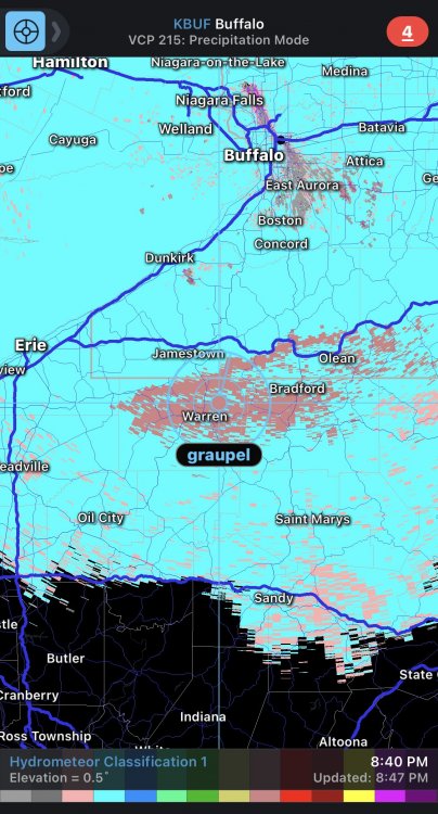
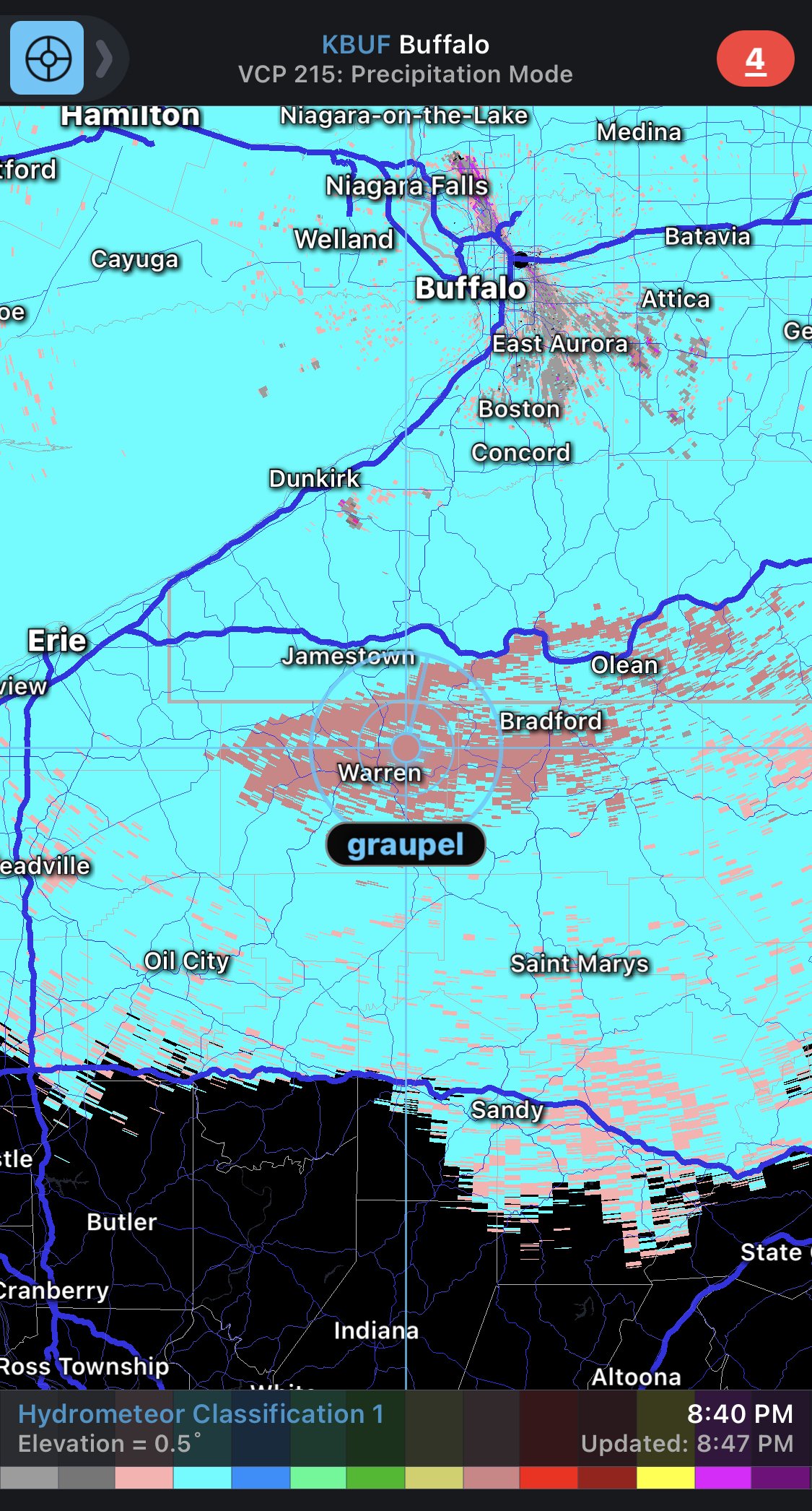
Holiday is north of the mix line on correlation coefficient. It’s sleet/ZR in Olean.
Well not that I trust this all that much but this shows just an area of graupel which could be plausible under strong lifting scenarios. It shows snow south of that area. But again this is mode is far from an exact science.
-
I mean that might not be a mix. It might be insanely heavy snow.
-
 2
2
-
-
Jamestown is at 21 with snow. The beam might just be hitting a shallow melting layer so maybe not a true issue yet. Regardless, there is much deeper moisture moving in fast. It’s gonna get good in a hurry

-
3
-
-
1 minute ago, BGM Blizzard said:
What's the strategy for snowblowing? Wait for it all to fall? When was the last snowfall that you had to use it?
I find it more enjoyable to throw a lot of snow. The machine works better under a moderate load. I also just like to do the whole yard and driveway meticulously at the end of the storm one time. I’d only clear it earlier If the plow stuff at the end of the driveway is deep enough to prevent my wife’s car from getting in or out.
Some people don’t like car tracks so they won’t drive over it without clearing it first. When I’m chasing these storms I’m in and out too much so I just live with some serious car tracks. You can still have a clean looking setup with car tracks if you keep your edges nice.
-
2
-
-
Excitement is setting in seeing that radar blowing up right now. The whole thing hits between 10 and 6am so that sure makes it a bastard to chase. I may take a Jeb drive around midnight. Should be cranking.
-
4
-
-
Wow, we posted that at the exact same time! Thats freaking weird.
-
This storm sure is a pretty one. Quite photogenic on the IR at least. A very well developed comma head.
https://weather.cod.edu/satrad/?parms=continental-conus-13-48-1-100-1&checked=map&colorbar=data
-
22 minutes ago, BuffaloWeather said:
All I meant was they're having a really good stretch up there.
I got you brother. Wasnt trying to knock you, I just think its important we don't inflate numbers. This forum lives and dies on accurate snowfall totals so giving someone a free 2 feet when they probably got 18" doesn't seem fair. It's easily the most snow I've seen them get from a trajectory like that.
-
12 minutes ago, OSUmetstud said:
The Burlington area got 12-15", on the 12th, then a similar area got 4-6" on the 13th. You won't find it in the Hamilton airport totals because they're much further inland. Those easterly lake effect bands usually form in very light low-level synoptic flow in arctic airmass, so they don't extend very far.
Ok good, I'm glad we confirmed that no one got 2 feet. I didn't see a single verified measurement over 25cm.... and for reference. 2 feet is 60cm.
Anyway, I'm done nitpicking
-
12 minutes ago, BuffaloWeather said:
They just got 2' from Lake effect a few days ago.
Ok, so does that make another 15 more or less impressive? I'm also highly skeptical anyone got 2 feet. 12 inches sure, 18 maybe.... 2 feet.. nope. Not believing that for a second.
Anyway, good for them though. That's one of the worst places in the whole Great Lakes in regards to getting appreciative snow. I'm sure their local snow nerds are in their glory.
-
24 minutes ago, BuffaloWeather said:
Hamilton been having the best run in its history I think
City of HamiltonA major winter storm is expected.Winter storm tonight into Tuesday morning giving 25 to 35 cm of snow.Heavy snow is expected to develop over the entire region this evening and persist into Tuesday morning where at least 25 centimetres of snow is expected. Northeast winds gusting near 50 km/h will result in very poor visibility in blowing snow especially from midnight to Tuesday afternoon.Even higher amounts of snow may be possible, up to 40 centimetres, in some locations due to extra moisture coming off Lake Ontario. Locally higher amounts may also occur on the higher elevations of the escarpment.Travel will be extremely hazardous until the snow moves east of the region on Tuesday morning. Local blowing snow may persist until Tuesday afternoon.I mean any snow in Hamilton is impressive, but 40cm is only 15 inches. Which is more or less what a lot of this forum thought we were going to get just a day ago. It's not earth shattering stuff though.
-
Seeing the current storm cruise NW gives me very little hope that Fridays storm won't be a washout. ****kkkkk., we were so close to getting two bangers back to back. This shit is stressful
-
2
-
-
26 minutes ago, rochesterdave said:
Transfer saves the day
Yuup! This storm is turning into a mini Miller B with a pretty obvious secondary firing up off NJ on Tuesday morning.
-
2
-
-
6 minutes ago, SnowLover22 said:
The good news is... everything goes well this week and we are average. So after this week anything else is gravy. If this week goes well the winter automatically gets a B+ no matter what happens next.
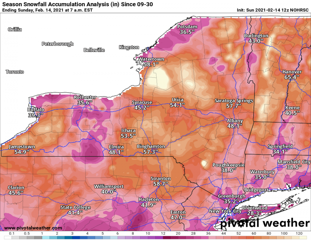
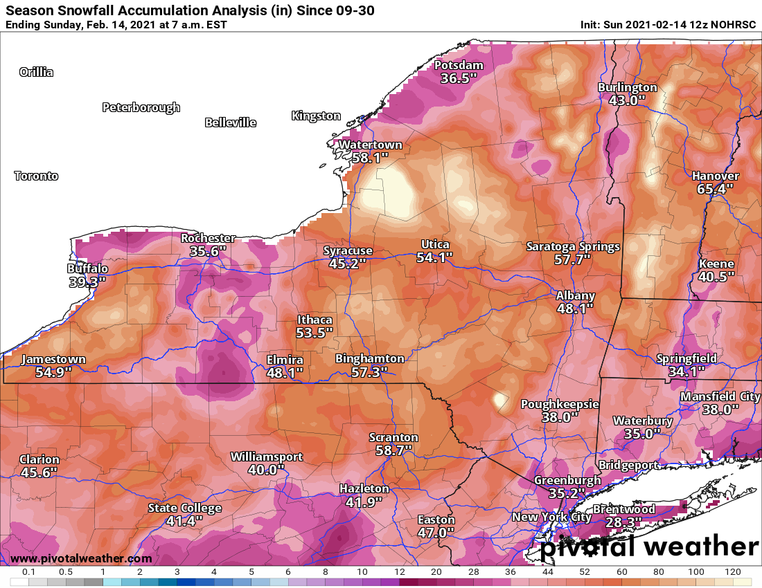
That map is a little out to lunch. Current official numbers are all above those:
BUF - 58
ROC -47
SYR - 51
BGM - 82
ALB - 49
-
1
-
-
1 minute ago, mississaugasnow said:
As a kid I would try to put all the snow in two piles. One at the top of the driveway and one at the bottom. I currently live in a townhouse now so instead I only go one direction and thats my tiny 30 foot by 5 foot piece of "front lawn". The wife thinks its funny that I do that and its noticeable to everyone in our neighbourhood haha. Everyone else has uneven snow piles but ours is already about 3 feet tall by 5 feet wide. Excited to see what happens with this storm haha.
Yesss! I’m always purposely making my one pile way bigger than need be by shifting a lot of snow around. It’s currently the biggest it’s been since 2015. Might be in record territory by the end of this week.
I’m glad I’m not the only one that does this! Haha-
2
-
-
I’m sorry for the eastern folks who will be dealing with sleet but I’m loving Rochester riding the taint hard. Right where we need to be.
-
1
-
-
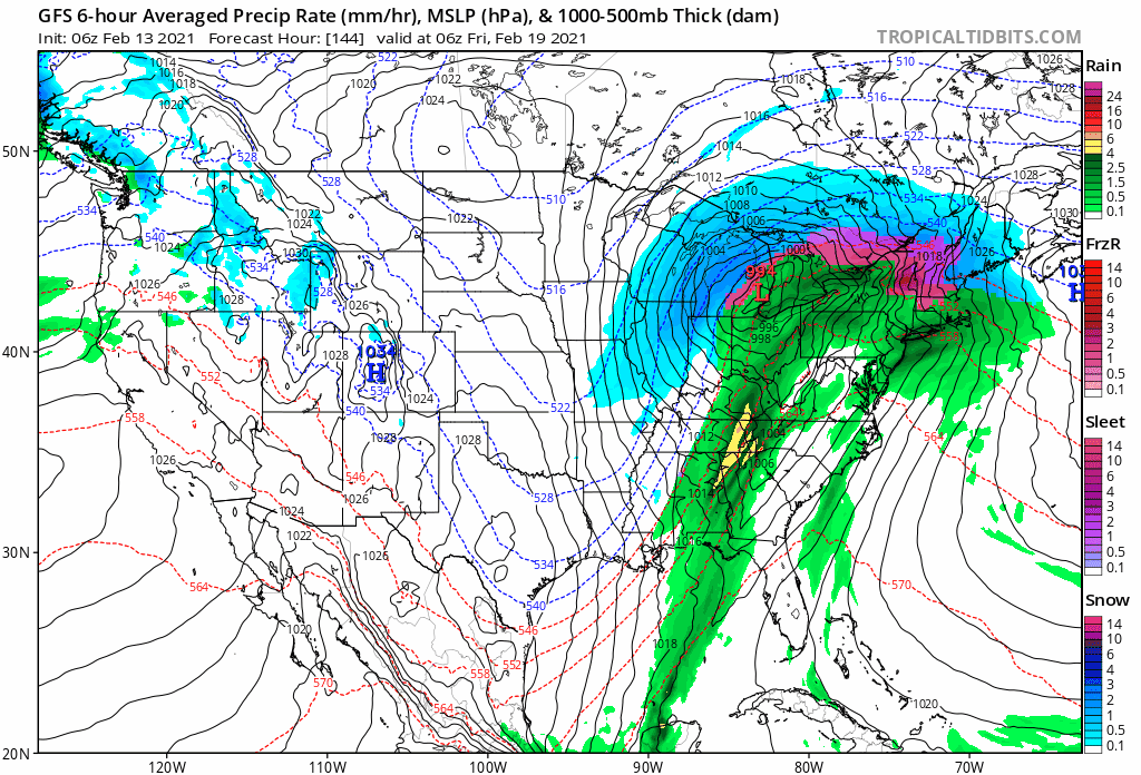
As most have mentioned, (but I wanted to just see the GIF myself) the GFS has been making sold and consistent moves in the right direction for 6 runs in a row. I would do anything to avoid that cutter...

-
3
-
 1
1
-
-
This first storm really looks pretty solid. Seems like very little chance for it to bust. Only thing I would change would be the forward speed, but all in all a sight for sore eyes.
-
3
-
-
Buf - 10
ROC -12
Syr -10
Bgm -7
-
2
-

Back to Back Major Synoptic Snowstorms!
in Upstate New York/Pennsylvania
Posted
That Friday storm is somehow missing out SE in the last few runs so sign us up for a NW jog late in the game.