

DeltaT13
-
Posts
3,006 -
Joined
-
Last visited
Content Type
Profiles
Blogs
Forums
American Weather
Media Demo
Store
Gallery
Posts posted by DeltaT13
-
-
4 minutes ago, lakeeffectkid383 said:
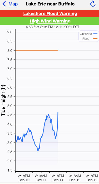
Water level subsiding now. Back down to 10 ft and falling. Winds have definitley began to calm here
Yup, winding down here. That’s the sad part about wind events. They are very front end loaded. All the action happens in the first hour or so. But power is out here and trees are down so I’m content.
-
Just lost power and we never ever lose power!
-
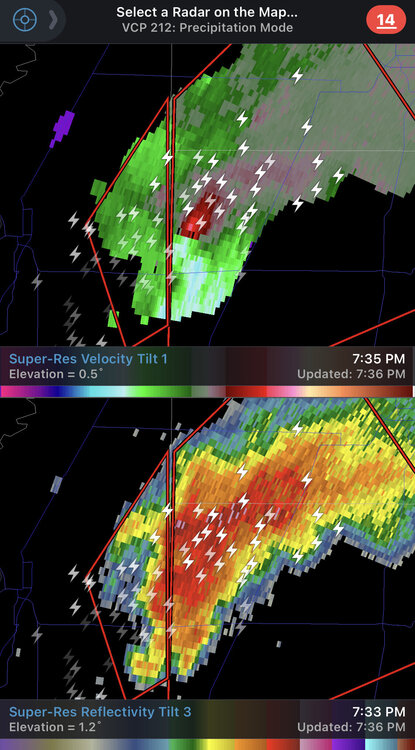
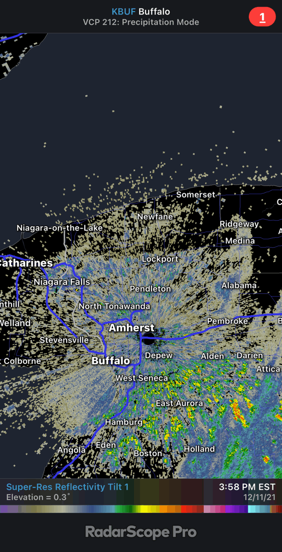
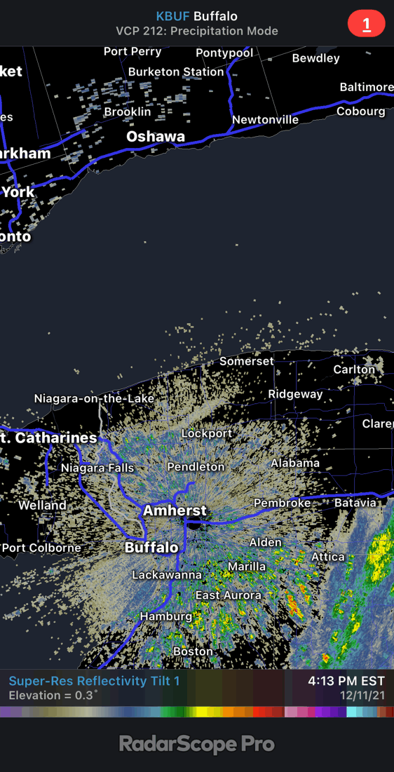
So tomorrow we get to solve this riddle. What on earth is this weird radar signature. Is it mist from the falls, trash from the landfill, birds from the landfills, smoke from a fire? It’s certainly not precip. Very interesting.


-
 1
1
-
-
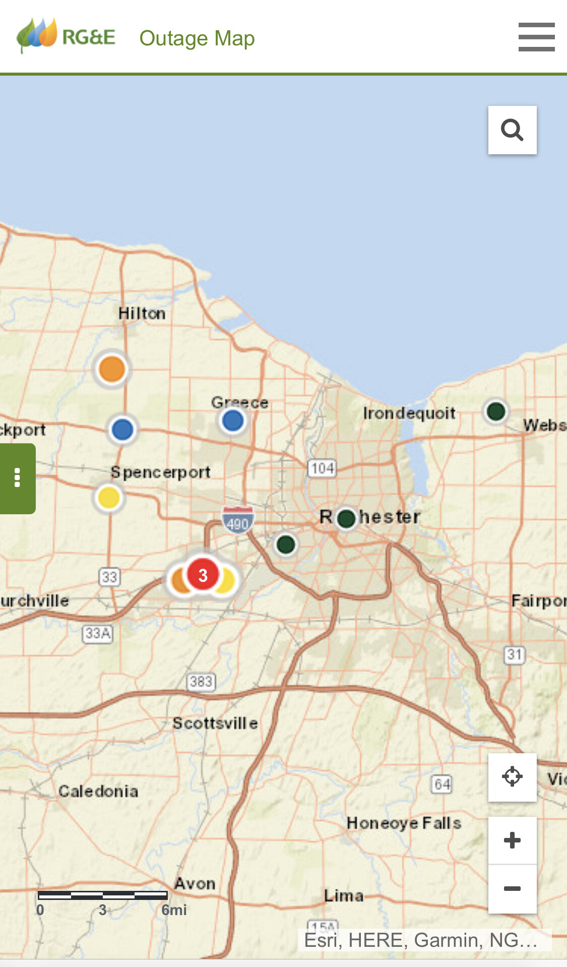
Outage map starting to light up now.

-
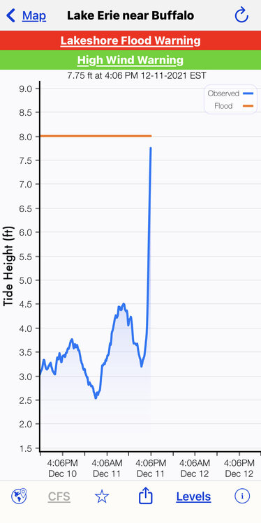
Lake Erie going to the moon!
-
 1
1
-
-
I’m out chasing on the westside and power just went out over what seems like a wide area. Getting pretty intense!
-
2
-
-
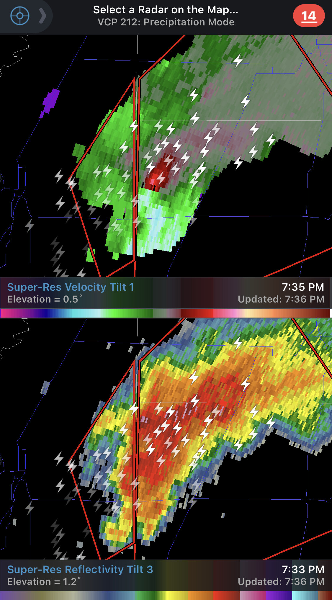
It’s blasting off.
-
KBUF airport already reported 60mph gust so storm has basically verified in the first 10 mins. Pressure on the rise.
-
1 minute ago, vortmax said:
When's that seiche coming in?
Might guess is between 4-430
-
1
-
-
It might be a dry/silent frontal passage on radar.
-
6 minutes ago, BuffaloWeather said:
Nothing special from that cell, I always thought the strongest would be 3-5 pm. Highest gust probably 25 mph from the line
I don’t think that was the front. That’s prefrontal. You gotta watch the barometer now. 30 mins after it starts to rise.
-
1 hour ago, tim123 said:
Reminds me of March from like 5 years ago.
Our greatest storm ever but that was a completely odd and anomalous setup. Nothing at all like our textbook events which is why it caught us all off guard. Full powerful March sun mixed down a strong jet from a storm way up in Canada. A really odd one.
-
Fantastic morning at the links at greystone. They even let us take carts out!
-
3
-
-
12z NAM is bumping the frontal passage up by almost 30-60 mins. Adjust accordingly Lake Erie chasers!
-
1
-
-
9 minutes ago, vortmax said:
Thinking this indicates a stronger synoptic situation for everyone or just a more favorable wind direction for ORD?
The system as a whole appears a tick or two stronger than forecast at this time which is unusual. They usually verify a bit under guidance so this bodes well for higher end wind gusts. As for Michigan, I have no idea how they weren’t under warnings two days ago, that seemed like a slam dunk with their earlier timing of the frontal passage.
-
1
-
-
41 minutes ago, lakeeffectkid383 said:
Dude winds are already sustained at 31 gusting to 45 at BUF , wth?? There’s already a constant low roar here in Derby and the front is 6-8 hours away. Have a gut feeling we’re going to be seeing some 70+ mph gust on the Niagara Frontier today.
I think these are the normal downsloping winds ahead of the system. Should be a lull for a few hours before the front comes through.
-
1
-
-
4 minutes ago, tim123 said:
Wind gusts to 64 in Chicago under a advisory. Much stronger than forecasted
Upgraded every county in our CWA to a warning which is pretty rare too
-
5 minutes ago, BuffaloWeather said:

That has to be an Ef5. Just wow.
-
Look at this tornado in Arkansas!
 !
!
-
1
-
 1
1
-
-
40 minutes ago, vortmax said:
Anyone buying this?
Not a chance but even knocking 10-15mph off those is still serious business; so we’ve got that going for us…which is nice.
edit - I shouldn’t say not a chance. They aren’t as high as I thought. If we had that noon frontal passage id believe it.
-
Honestly just stay under 200 hours on these models and you won't have to worry about this fantasy bullshit.
-
4
-
-
7 minutes ago, wolfie09 said:
Looks like the potential for another above average month wrt precipitation..
Last month finished at nearly 6" and 2.5" so far this month, more to come this week, too bad it doesn't translate to AN snow lol
.gif.0f88573577fb2bd15eb2f2f3cd785e58.gif)
Nice to see Cali getting a lot of precip love!
-
1
-
-
40 minutes ago, BuffaloWeather said:
what time for max winds off erie?
There are two times I would focus on, the narrow low topped squall line with the frontal passage and then about an hour after that once the CAA really kicks in. Frontal passage is at about 330pm on the hi res models, then 5-6pm looks like the best long duration sustained winds with max gusts. We can tune this up as the new runs roll in, but things look pretty locked up. I'm thinking Southern Ontario really takes this on the chin as they are a few hours ahead of us.
-
1
-
-
That razor thin low topped squall line might be the highest peak winds, which should only last for 2-3 minutes, but often times thats all it takes to cause some serious destruction. That's the only thing that will really tap the low level jet. Then I expect about a 30 minute lull until the CAA kicks in at which point we get the general sustained winds around 35mps with frequents gusts in the low 50's. Should be all over by midnight, if not a few hours sooner. Generator is ready and I may take a drive around in those post frontal winds for a bit.


Upstate/Eastern New York-Into Winter!
in Upstate New York/Pennsylvania
Posted
No power here since 530pm yesterday. Drove around today and didn’t see all that much damage. The worst I saw was just 500 yards from my house.