
David-LI
-
Posts
1,278 -
Joined
-
Last visited
Content Type
Profiles
Blogs
Forums
American Weather
Media Demo
Store
Gallery
Everything posted by David-LI
-
Will that line of storms make it here this time or will it dry up too over LI?
-
There are also storms modelled for tonight around 11pm-12am
-
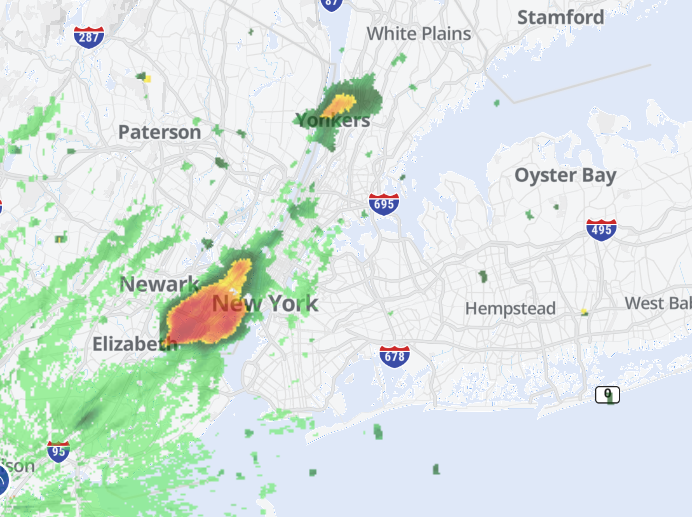
 Seeing storms on the radar in W PA and NW NY. Hopefully we get a late afternoon thunderstorm.
 -
SEVERE THUNDERSTORM WATCH OUTLINE UPDATE FOR WS 441 NWS STORM PREDICTION CENTER NORMAN OK 125 PM EDT THU JUN 19 2025 SEVERE THUNDERSTORM WATCH 441 IS IN EFFECT UNTIL 900 PM EDT FOR THE FOLLOWING LOCATIONS NYC001-005-007-017-019-021-025-027-031-033-035-039-041-043-047- 057-059-061-071-077-079-081-083-085-087-089-091-093-095-105-111- 113-115-119-200100- /O.NEW.KWNS.SV.A.0441.250619T1725Z-250620T0100Z/ NY . NEW YORK COUNTIES INCLUDED ARE ALBANY BRONX BROOME CHENANGO CLINTON COLUMBIA DELAWARE DUTCHESS ESSEX FRANKLIN FULTON GREENE HAMILTON HERKIMER KINGS MONTGOMERY NASSAU NEW YORK (MANHATTAN) ORANGE OTSEGO PUTNAM QUEENS RENSSELAER RICHMOND ROCKLAND SARATOGA SCHENECTADY SCHOHARIE ST. LAWRENCE SULLIVAN ULSTER WARREN WASHINGTON WESTCHESTER
-
Storm cells popping up in NJ and moving in the area earlier than modelled. We might be in for a stormy afternoon.
-
why the big difference between gfs and euro? why are they showing diffrent solutions? who will win? euro is king no?
-
I think it looks fine
-
NEG NAO
-
upper level features don't look good and no proper phasing.
- 993 replies
-
- 2
-

-
- metsfan vs snowman
- bomb
- (and 2 more)
-
988 at BM means nothing if the dynamics are not good
-
Amen
-
- 993 replies
-
- 3
-

-
-

-
- metsfan vs snowman
- bomb
- (and 2 more)
-
EPS is a miss too.
- 993 replies
-
- 2
-
-
- metsfan vs snowman
- bomb
- (and 2 more)
-
you already have the euro? it's still running
-
And if the GFS verifies it's another major snowstorm starting Saturday and ending Sunday.
-

-
every1 really excited for a storm 7 days away?
-
That's a short range model. At hour 69 it's not too accurate.
-
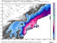
Too far out but we can have a white xmas
-
Are you being serious or sarcastic? Because this storm is so far out that IF it actually happens, this map will change dozens of times both in intensity and location.
-
I just felt a nice cool breeze on my window. Can’t wait for the cold front.
- 1,764 replies
-
- 1
-
-
- hurricanes
- tropics
- (and 5 more)
