

Typhoon Tip
-
Posts
40,582 -
Joined
-
Last visited
Content Type
Profiles
Blogs
Forums
American Weather
Media Demo
Store
Gallery
Everything posted by Typhoon Tip
-
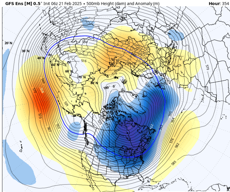
Agreed ... but it may be transient. I'd like to say we turned the corner but the longer range has different ideas. There may only be a relaxation in the recent relative cold persistence for 5 days but that deep range -EPO ... it's going to load cold anew but where? After that rough Mar 2 -7th -EPO the hemisphere evolves into a strange look - all the ens system agree too so no luck there. 90% of all negative anomalies in the entire N hemisphere are compressing the flow from Chicago to S of Greenland toward the end of the first week of Mar. This being directly after said -EPO, it's like the ballast of all the cold available is completely displaced off the polar field, and is jamming SE. Spring canceled if this sets ... period! Not saying it will... Strange orientations like this sometimes have a way of not happening. LOL. This is about the only way to be cold when the numerical fields derive to a +EPO/-PNA/+AO/+NAO (the NAO may be +23 here!!)
-
Decreasing in significance.. The ensembles appear to be getting more members opting toward a frontal pass with a wave on it, rather than an organized kink cyclone on the boundary that rides up after like those tastier runs before. The operational versions almost lost it all together on the 00z cycles ... I'm sort of losing patience with these models correcting faster/progressive, in the sense that I don't believe any of these "threats" any longer. Not sure how one can after this unflappable persistence to degenerate storm spaces. They're (models) are doing it again... the whole season's been plagued by this rug pulling aspect. It looks like a thing may just work out but as the period in question moves into mid range, the heights lower too much from the N two aspects begin: offsets the short wave strength; speeds things up so that even if we got something of it it's barely an afternoon's worth.
-
yeah those last couple of frames is suspect considering the changes that have taken place... We'll see. I was talking about the operational run -
-
yeah i don't get that behavior. cultural relativism is for the birds, that straight up looks like a Darwin thing happening - hopefully it works.. help with the global population issues
-
Oh, so rainy ... hm
-
I actually don't hate the 28th - heh, things break according to the tele's that's the last snow event of the season ( prior to bowling ball times.. but those are something else) But the flow is relaxed(ing) with more a backed off EPO allowing the western component ridge of the total +PNA mode to maybe for once this year actually pop a bit more. Just setting the table here...
-
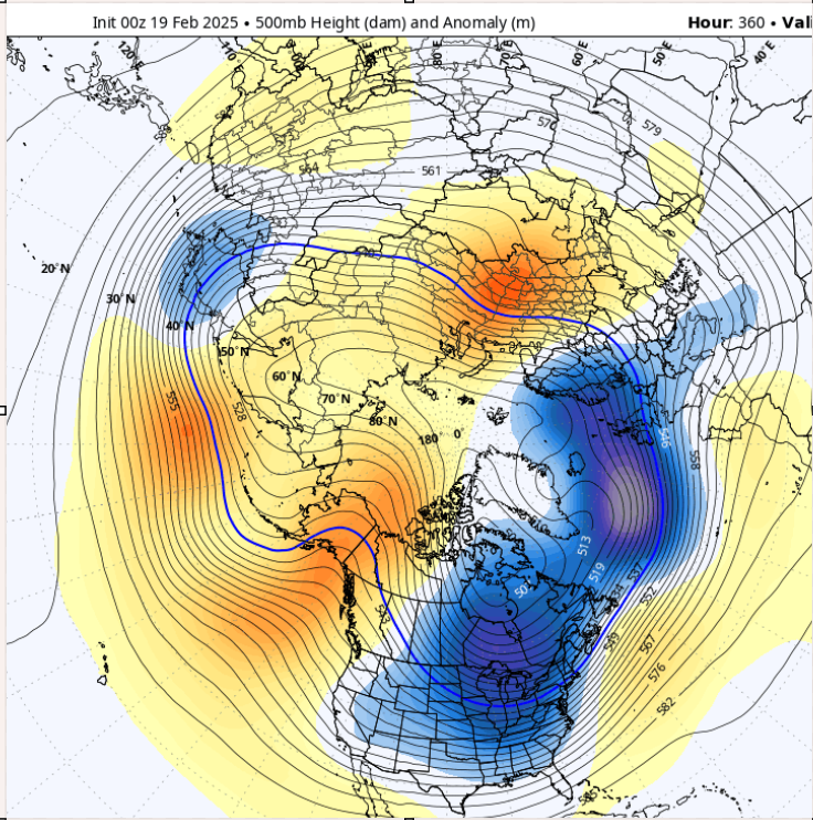
It's in the extended so tfwiw ... but this 12z op Euro definitely retreats deep winter mid way through this run. By mid way thru the first week of Mar the hydostratic height (thickness) tapestry S of the Can/U.S. border is increasingly more flaccid, with a lot of > 540 showing up as far N of central IL-OH valley. Spring vibe for sure.
-
and I don't think it's below normal per se across NNE ( temps) ? maybe that's changed.
-
Looks like that through about the 7th...10th of March, yeah. But, I also caution ( you know this... ) if the tapestry of thicknesses relax at all, you know how folks get kind of disconnected. After all this time, people may forget that our rest state will bounce - not going to address the why-elephant. I'll just keep it to the notion that we're after solar min, so a 537 dm afternoon with light west wind and sun will highly likely propel the temperatures over most machine guidance, and/or probably the cold addled forecaster's expecations. LOL. The old nape season bust factor... We may need some time to get reintroduced to the real world when this -EPO dominating thing relaxes. There's one more pulse of that ( for now ..) next week... it may play a role in the 28th thing, we'll see on that.. 6z GFS blah blah. but after that, it looks interesting the longer range. All sources still insist a bigger collapse will happen around that temporal boundary. It's not being pushed back either. Probably it will eventually can kicked at least a little. Never seen a warm up in spring happen on time - we could go Venus on Earth, and Earth will find away to point Labrodor's giant cryo butt at us, and then deliberately overdose it with laxative. But hey... if an Ides +EPO/-PNA/+(AO/NAO) can somehow soar us from this, to that... that'd be pretty cool to see.
-
Nah...same shit of moving too fast for that... In fact, I'm a little bemused by the relaxing compression yet the S/W remain so fast. I think the whole arena past the 25th is going to probably be reworked in future runs.
-
It's another failing phase ... the Euro reflects both the S/stream and the N/stream separately
-
I applaud the Euro for detecting ... ... this season's achievement in snowing the least plausible amount relative to any physical circumstance is finally being modeled by one of these damn things. The 28th signal on this run has a coastal running up with an impressive nor'easter signaled, yet nothing happens on the west side of the cyclone the entire way up the coast. that's a neat trick... but then again, I don't put anything past this season at this point.
-
He launched an invalid interpretation of what I was discussing ... you bit on it as if that interpretation was correct, therefore ...blah This is how our society got a demagogue into power - just expand that spontaneous misrepresentation of facts, and how it grows into an asshole tree, out to the dimensions of a society, and that is how the shade under which our culture no longer sees the sun
-
heh... depends on what people have in mind when visualizing what "out" means Spring in New England is an assault to humanity by god himself. Let's get that clear haha. I mean, you're going to eat shit some how, some way. In this forum of malcontents ... we'll probably just relay seamlessly into whining for the next abysmality. We could sans the cold .. but eventually we'll have to pass through the Aprilian gauntlet ... a terror of Labradorian ass-blow. I got to say, after a winter chalk full of blocking episodes and an unrelenting cool bias that is targeting this specific region the planet ( see chart a few posts ago...), this spring just reeks of a big ass on climate laxative. So what does out mean.
-
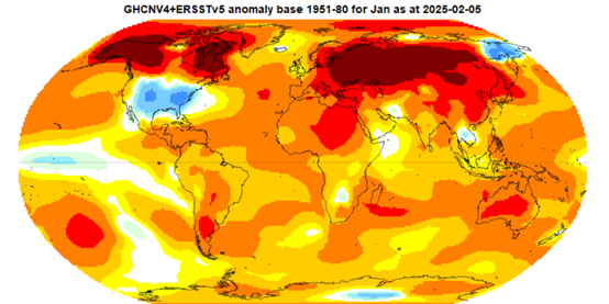
All complexity aside ... there is a present tendency to slip back into the exact same persistence the caused this oddball anomaly distribution below... (granted that's just January, but ...mm fuck me if Feb isn't the same. We'll see - ) In fact, if you look at the EPS mean in the previous post and map it over this, the pattern of the EPS going into and thru the first week of March, fits this temperature distribution ideally... That all argues for persistence of Jan/Feb to continue rollin' on. The trick is, when does persistence break? At some point in will... I mean in a snarky sense, July is still going to happen so this bs enable cold fan-base to bury their heads in it can't go on forever. LOL.
-
This is for after March 1 well, ... like I said, the -EPO/-PNA applies a different correlative pattern, compared to a -EPO underpinned by a low frequency +PNA state. If using just the teleconnector correlations: The former is the west loaded cold, east warm up scenario. The latter is a oscillatory cold pattern in a more sustained BL, one that is then occasionally stung by modified frigid pulses - this particular winter's version. ... As an aside, you'd think that option B is the better snow storm producer - in principle, you'd be correct... However, this compression issue, which I feel is being enhanced by CC and attribution ... is creating a circumstance where in order to sustain an option B, there is destructive interference related to compression/speed mechanics. Cold is causing it because it just improving gradient whenever it exerts into middle latitudes... Anyway, the larger synoptic hemisphere cinemas of the ens means, don't look warm anywhere frankly. So this is one of those situations where math says we actively start seeing recovery in the east, while the placement of major features in the synoptic overviews do not. I'm not totally sure which way to go there. One of the other may move toward one or the other. 50/50. In the meantime, nothing backs the concept of early 70s in D.C. like this,
-
Really? Do you have another source than CPC, below. This is the 3-month tendencies so ...maybe pulling Feb out the three shows something else, but "high probability" doesn't quite sense right either
-
-EPO reload in both the tele's, and the spatial handling of the synoptics. The PNA is different this time. It's -PNA. That's changes that map a little...
-
Yeah the GEFs was actually even more aggressive with a new -EPO in the first week of March, and the EPS appears to be collapsing. Two days ago this was not there in either, and it's now dominating the spatial layout out of nowhere. Can't say it's a bad outlook... Persistence alone may force hands. So, for winter/cold enthusiasts, that's a good sign for more near misses because of poisonous speed flow footing. The WPO remains neutral or even modestly positive so... hopefully for spring/warm enthusiasts, that will abase the GEFS/EPS and go on to verify at least a nominal temperature theme.
-
It becomes .. or 'might' become, particularly more intolerable during these sunny afternoons of latter February. I mean, it'll be hard pressed to find a sky that pure in the warm season around here, so in some respects the actual photo-ocular effectiveness of the sun's "shining" is going to be even more triggering then a day in May. So then you walk out there and your stunned by the cold - that's the intolerable thing. Your mind was trying to associate that brilliance and so conjures unresolvable nostalgia.
-
It was a response to your sentence: "Hanson is right that aerosols are key for untangling our recent climate history." Beyond which ... I was just being very general in that missive. You may notice that I didn't cite any other source or study, data or conclusions therein? that's a red flag for rhetoric vs meaty value. LOL Silver bullet may sound strong, but that's just semantic word choice for affect. Key. Main factor... whatever - But, I do believe there is real value/veracity in the idea that there is a range in a kind of consequence spectrum that is quite unknown, more importantly, that planetary ( PLANET ) wide huge movement is a warning that such unknowns have an intrinsic risk
-
Heh ... been awhile since we had a NAM coup. Maybe it's time for a wiener solution to work out
-
exactly what I thought. and that is interesting -
-
I have a question for the storm vs dates folk. ... is there a list of of dates out of the NDJFM months that did not have a snow storm? - and 2" of snow is not a storm in that question. In fact, any such list of orphaned dates is less than 6" obviously, the first couple of weeks of N and the last couple of weeks of M in that list we would be likely to find some ...so it's more for DJF.
-
Definitely looks shaky to me as of this morning... There's a new -EPO flex out there in the GEFs mean, that the EPS has been reluctant to see for whatever reason. This regards the period(s) after 3/1 ... The GEFs have been performing remarkably well with that particular factor, all year. Each one that it detected in this two week window has actually verified pretty damn well. There's just one difference this time - which I'm not sure of... The WPO is not a part of this particular new decline in the index. Priors had the advantage of an ongoing negative WPO. Such that every time the EPO was projected to rise positive, the WPO's persistence in negative during was a red flag. Those two are tightly correlated given some lag - a lag that makes sense given that the WPO is west of the EPO in domain coverage .. and so on. SO, I have seen charlie brown EPO index forecasts in the past by the GEFs too. And since attacking clad forecaster projection efforts appears to be an intangible storm this season ( LOL ) this would be a perfect opportunity for the GEFs to set up another "gale." The entire sensitivity to warming up in March - other than sun and seasonal .. - is related to the EPO sourcing from what I am seeing. If we remove that, we will recover. In fact, there's already operational signals that the deeper cold thickness may relax next week from 40N and lower over the continent, and the nearer term rise in the EPO is red handed. By the way, the EPS has a signal for the 28ths. Both the GEFs and the EPS have a "bump" in the PNA, despite the GEFs not being quite as interested in manifesting an actual event. But seeing as both have a signal in their respective telecons, there's plenty of time for the the GEFs to emerge one.


