

Typhoon Tip
-
Posts
40,581 -
Joined
-
Last visited
Content Type
Profiles
Blogs
Forums
American Weather
Media Demo
Store
Gallery
Everything posted by Typhoon Tip
-
Spring 2019 New England Banter and Disco
Typhoon Tip replied to HoarfrostHubb's topic in New England
Three cycles and counting and I love the rendition illustrated by the operational GFS ... Parallel run not too dissimilar, as is the GGEM... though differ on details... Between 18z Saturday and 00z Sunday ... 70 to 74 F along the Pike while there's 1.5"/hr snow rates along the N side of the St L. Seaway... That's pretty neat to see - ... -
Spring 2019 New England Banter and Disco
Typhoon Tip replied to HoarfrostHubb's topic in New England
Ha ha... Folks ruminating on the seasonal change with Hostas and Lillies and gunk and y'all can't have it - they gotta come in drop winter post-bombs to yank it back into perpetual winter immersion support group ... It'll be July 10 and same thing... I know - -
Spring 2019 New England Banter and Disco
Typhoon Tip replied to HoarfrostHubb's topic in New England
-
Spring 2019 New England Banter and Disco
Typhoon Tip replied to HoarfrostHubb's topic in New England
Lazy spring vibe out there ... I got those tiny aerial insect balls hovering .. bobbing left right up down in unison over the hood of my car and lawn. Sure tell sign of the times ... Too bad it's going to regress colder 'n a Mastodon's unthawed anus for three f'n days. That's spring incarnate around this god-forsaken geographic circumvallate of an orifice known as New England. It does that every year ... a day like today, it's a super hot fantasy girl kissing you on the cheek. And while your eyes are still closed in awe and ecstatic joy, this nasty horror story of a prison gang banger guy swaps out and ass reams you relentlessly. Your squealing in agony like a pig while he's asking you how that nice day felt - Am I gettin' through ? If I were a millionaire ... I would own a separate residence, replete with comprehensive homeownership insurance. The abode just sans of any heirlooms or family prized possessions, ...And there I am, out there, amid the warm windy prairies somewhere in the swash of tornado alley. Towering leaning turrets and wavy sun simmered air ... While it's 39 F in Framingham, Massachusetts with mist, slate gray sky and a thoroughly caressing east wind. I would gladly forsake the New England mock-spring and tortured persecution complex ... and flee to that second home circa late March until early June, or mid May. Or whatever it takes... If the place happens to get clocked and has to be rebuilt, I re-emerge out of my tornado cellar no worse for the wear and just wait out my insurance coverage to rebuild. See... I'm not there living per se... I'm there to escape this prison; perennially, I leave behind all the other hapless cell-block assholes, left to ponder as they sit around and rationalize and quibble over how here on the inside, we hold out hope for snow through April ... Delusion over despair. I innocently strollin' on come back in May and am like, "Hey y'all - whatcha been up to" haha. Ah yes... "Spring" in New England. I'm kidding - of course... But I think it was Samuel Clemens A.K.A. 'Mark Twain,' who once famously quipped, 'the worst winter I ever experienced was a summer in San Francisco' ... the dude never spent April in New England I can guarantee that, because while I would never diminish the misery behind his motivation for saying that of our west coast brethren, I certainly would put spring right in there in New England, as worthy of an honorable mention. -
7" here in NW Middlesex country ... Just made the winter storm warning criteria ... heh, the 8th seed in the NBA... "National Blizzard Association" playoffs Now 38" on the season at mi casa
-
Heh... this was too well advertised and also empirically too larger in scale to fit with the 'little critter' concept - Bozart et. al. unless you just meant that for colloquialism
-
Perhaps a Coastal Storm on March 2nd for SNE????
Typhoon Tip replied to USCAPEWEATHERAF's topic in New England
It's interesting looking at this (time-sensitive?) image provided by WPC ... Just how much of this thing is entirely produced by mid-level forcing, as anything associated to cyclogenesis appears quite suppressed... Weak low east of Del Marva, with a track trough situated ENE, doesn't scream in favor of the low positions offered by many guidance' I saw leading up - looks like the low position its self may bust S ... just estimating. We're actually closer to the high pressure centered near western Maine; while we brow rub over the northern extent of snows... I'm almost surprised it is snowing as much as it is from PVD to PLY where that band even exists, probably owing to the mid levels smeared NW. For me astride Rt 2, with that fog-snow (yes some aggies ..) But.. this whole structure at mid levels did have a negative elongation as was modeled in the blend so... yeah, they did okay there. All and all, feel pretty satisfied. The last entries last night seem to have verified rather nicely as Weatherwiz and I mentioned... This was slated to be a narrow corridor impactor, hauling ass! You may even be lording over your device or PC in a gray ambiance between noon and 2 pm when suddenly ... forced illumination glows the room. This is an interesting time of year... In the heart of this thing, it's deep winter by appeal. When/if the sun comes out two hours later and the wind stays light, the faux nape warmth that Kevin gets watery-eyed for, along with heated interior of his car ... really does provide two disparate perceptions that he often waxes nostalgic for. We'll see on the latter... The sun angle is climbed enough that a shallow saturation absent lift can evaporate below a weak inversion more effectively than it would in one of those the wood-smoke afternoons of early January. Anyway, we also said that sat and rad can be deceiving. It's interesting that both seemed to work out... The results this morning appear to be a blend about mid way between the high res ... plug pulling toaster party late last night, together with radar looking too neggie and ending up perhaps a little bit farther N... As was evidence(d) by the content dumped into this social media between circa 8pm and midnight ... this thing was a worse performer than what is taking place, while also still being somewhat more compacted S. Interesting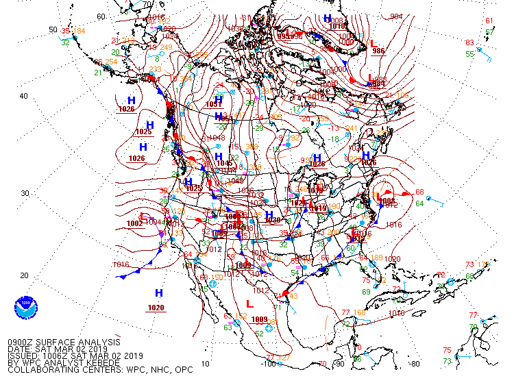
-
Perhaps a Coastal Storm on March 2nd for SNE????
Typhoon Tip replied to USCAPEWEATHERAF's topic in New England
F - !? Not the dreaded minus F. Pay attention folks. Very rarely is there a winter actually worse than a failure. Wtf does that mean, F- haha -
Perhaps a Coastal Storm on March 2nd for SNE????
Typhoon Tip replied to USCAPEWEATHERAF's topic in New England
I was just going to say… Extrapolating radar doesn't snow north of New York City. But like Will and I were talking about earlier's radar and satellite and stuff can be deceiving. We'll see -
Perhaps a Coastal Storm on March 2nd for SNE????
Typhoon Tip replied to USCAPEWEATHERAF's topic in New England
mm... k, buuut... there's some large more super-synoptic scaled arguments I've had all along in mind, that sort of keep/kept me from being too bullish. I could see it going either way - still within margins of error to go only 50 % of consensus totals, and due to the endemic uncertainty with an inherent "needle threader" system and exact course and banding, having weird strike back gashing from HFD- to BED I could see that too... Barring the lesser likely, though, this "should be" a narrow impactor, hauling ass like bats leavin' hell. Translation timing alone playing a limiting factor as well... Compressed, high velocity patterns limit impacts to narrow regions... doing so with middling over all mechanical strength has left me scratching heads to find where 6-8 " come from but again,.. margin for error is bit higher. The MESOs could erroneous for convective handling... yup, but ... maybe they should've been to high in the first place. -
Perhaps a Coastal Storm on March 2nd for SNE????
Typhoon Tip replied to USCAPEWEATHERAF's topic in New England
Filter turned off again ...? j/k.... good luck with your forecast -
Perhaps a Coastal Storm on March 2nd for SNE????
Typhoon Tip replied to USCAPEWEATHERAF's topic in New England
Speak of the devil... James just saved the day! ahah -
Perhaps a Coastal Storm on March 2nd for SNE????
Typhoon Tip replied to USCAPEWEATHERAF's topic in New England
Careful I've done that before, too ... go to bed feelin' really good about Sat and Rad trends, regardless of whatever disappointment was being evaded on my way to slumber... only to wake up wonder how in the hell said Sat and Rad didn't parlay better... Sometimes those loops sorta kinda like lie? you know - -
Perhaps a Coastal Storm on March 2nd for SNE????
Typhoon Tip replied to USCAPEWEATHERAF's topic in New England
'Been just sort of observing ... ( lost interest due to my perennial checking out that typically happens in March ...don't take it personally. ) It seems there is/has been a tendency to collectively lean toward higher amounts reviewing many pages in this thread. Then the subtle surprise when x-y-z run cuts back and, then a-b-c model suggests more and we forget the x-y-z... I just wanna add, I don't typically see big amounts from fast moving open waves... particularly when the wave its self has almost vague mechanical signature in the flow. I think some of this nearer term run-up attenuation of the development profile (talking Satur...), may be realism and correction pushing back against the above 'leaning'. On the other hand, just about any permutation in the Earth's atmosphere since about 50 years ago ...is going to have more moisture at its disposal ... so, comparatively weaker kinematics can ...I dunno, add a couple tenths or so... That's just fact - water output from island showers near Fiji, to enormous tempests in the GOA, to categorical hurricanes in the Atlantic... to thunderstorms in WeatherWiz's backyard... everywhere, the atmosphere is empirically holding more moisture and rate results are up. Not sure how much that facet should deterministically add to this thing, but, it's just to say that the same synoptic evolution in 1919 doesn't produce (probably) as prolifically as it does in 2019.. Worth a consideration... if only for a little more. The other aspect I'm toying around with is the "little critter" phenomenon - which is a euphemism (don't panic ) for when a seemingly innocuous perturbation in the flow goes flippin' nuts, which happens regardless of 1919 or 2019, too... I don't know this qualifies, ...I don't think it will ... but, most of those positive bust types take reanalysis to figure out why. You know, I saw Bozart's presentation back in 1997 when he first coind the expression to describe those head scratch six hour long S+er's out of nowhere... as I also recall the system he was using for his presentation. It was fascinating... 10" on a west wind along the pike and SE Mass is the ultimately left-fielder... Pretty sure it was Feb the previous year. Anyway, different story different time no analog. -
If there's any usefulness ... https://www.esrl.noaa.gov/gmd/ccgg/trends/full.html
-
Not entirely sure... CPC provides a lot of on-line 101 level essay and explanation text for their various Q&A and methods ...etc... They sort of tip their hat to 'not really normalizing for the hockey-sticking' (so to speak), however: What is the relationship between El Ni�o/La Ni�a and global warming? The jury is still out on this. Are we likely to see more El Ni�o's because of global warming? Will they be more intense? These are questions facing the science community today. Research will help us separate the natural climate variability from any trends due to man's activities. If we cannot sort out what the natural variability does, then we cannot identify the "fingerprint" of global warming. We also need to look at the link between decadal changes in natural variability and global warming. At this time we cannot preclude the possibility of links but it is too early to say there is a definite link. c/o: http://www.cpc.ncep.noaa.gov/products/analysis_monitoring/ensostuff/ensofaq.shtml#RELATIONSHIP Their exact data ranges may be buried in those links somewhere .. but, climate intervals are broken into different multi-decadal lengths for different uses. Edit, might be useful to note that even since 1980...the lion's share of mass occurred in the latter half of that nearly 40 year span
-
It's fascinating ... Perhaps time will expose that it's like a heat 'catch basin' that occurs during otherwise neutral times. It's an illusion of an El Nino event in that sense [if so] because it's only warmer than normal against 1950 but not necessarily in a neutral ENSO in 2020 ... hmm The other thing, NASA ...NOAA... tea leafs in china... whatever, they may already "normalize" the anomaly for the hockey-sticking... (I'm calling it hockey-stickinig, just means rapid rise at the end of the multi-decadal curve). That would make the "actual" Earth-relative anomaly (as in present tenths) more accurate. But, the atmospheric component of that is a quagmire -
-
well...yeah ...in your defense, I wasn't even considering the recent spatial science/delineation of ENSO anomalies - as in, 'where' the warmth is located out there. But it shouldn't matter - if there is a muting effect that is secondary to El Nino's presence ...because the El Nino is concurrent against a warm backdrop ...yadda yadda... It still would be influenced the same way. The problem here is that in a 'climate flux' ... you don't have Modoki this... and Nino 1+2 that actually IN that same historical framework... why? because it hasn't happened yet.
-
Well not in absolute terms like "...are not" ... I just want to consider the possibility of the latter ... to open some worth-while speculation and conjecture. I don't believe I've made any 'declarations' per se - if I did I miss spoke. Hot vs cold ...undulations occur...system finds a neutralized outcome. Hot vs Hot ... no undulations occur ...because system has no physical reason to neutralize. I just strongly believe it is worth sciencing whether warm ENSO events in a GW spike might try to approach the the hot vs hot model ...not necessarily be there. Throwing in the AO mucks it up further.
-
Ah...personally? I wouldn't be so confident in picking the effect of ENSO apart that way... Whether the effect of Nina(Nina) may or may not be physically manifesting at a given location/season, only belies it's presence ... or supports it, either way. But when it doesn't, it doesn't mean it's not there. It "sounds" like you're suggesting that? If so, ..no, it's effects are still ubiquitous. ..on going.. if only [more likely] being masked by whatever those other forces are hiding. 'Stateside' this and Philippines that ...I'd be careful with that. That very real and applicable concept is related to the AO part of this too. There are times when the N. Hemispheric pancake events and emergent blocking episodes will subsume the ENSO signal (though probably less than entirely...) and whether it does so and how much probably depends on the relative strength of either in time.. blah blah. Also, and hypothetically: El Nino is more than merely statistically shown to be a global phenomenon ... but, the majority of that history was in a relative quiescent/stable climate ... compared to the "hockey-sticking" we are observing world-over now. The point was/is ... that statistical inference/correlations may be a bit tricky. That's all... It has to be... A warming world doesn't supply the gradient distribution the same way - gradient is the whole machinery, period.
-
Mm... it was vetted/researched why the recent 'mega' nino did less comparative global impacts - Winters since have also been odd relative to enso - 2015 ...etc
-
yeah i routinely get that backward ...wrt to the direction there. but i'm not sure i know what you mean by 'warm ensos behaving in similar manner' ... ?
-
not to be contrarian buuut... I thought climo on warm ENSOs was for early cold/snow turn outs fading toward early springs... But, I don't know where Feb lands in that plan (exactly) ...it's a fence month. Seasons lag...it's the only reason why Novie's aren't on whole snowier than they are, and why Febbies aren't bloomin. the latter is getting more solar than the former. anyway, ...the warm ENSO isn't it kind of paltry? . .. i also have a separate hypothesis related to it's scale/degree of anomaly being less meaningful in a GW where/when the surrounding medium is also warm(ing)... that skews the total thermal source/sink relationship and quite intuitively, a warm(cool) ENSO event in a warm(cool) earth should reflect differently... plus... again, i don't think enough homage is necessarily applied to the AO - not Ray's outlook per se...just in the general ambit of the efforts for seasonal 'casting.
-
Not sure if this has been discussed so excuse any redundancy - I've accepted the notion smoldering underneath all this monitoring that the perennial ice is on a course toward extinction ... whether that reality is observed next year or decades away, notwithstanding. What I'm interested in is the "rate" of recovery over the seasonal transition. Those modalities are perhaps more telling about the drivers and forces effecting a system than the scalar statuses. Many of these more impressive cold wave winters (that may or may not have had concomitant snow storm efficiency) were led off by fantastic recovery rates with sea ice expansion, as well, with land-based cryospheric metrics, during the preceding autumns. I think it is also less systemically observable over antiquity because passed decades did not have as much exposed naked sea-surface, having ice more enduring during warm months ...such that said rates more likely merely went unnoticed. So, it's supposition...but, I suggest a rapidity in areal ice recovery ... along with land-based numbers, can be telling signs for an ensuing winter's arctic contribution to modulating middle latitudes around the Hemisphere - notice I said 'Hemisphere' and not 'local-yoke's backyard'...
-
Fwiw - https://www.cnn.com/2018/08/23/world/arctic-sea-ice-breakup-greenland-trnd-wxc/index.html


