

Typhoon Tip
-
Posts
43,236 -
Joined
-
Last visited
Content Type
Profiles
Blogs
Forums
American Weather
Media Demo
Store
Gallery
Everything posted by Typhoon Tip
-
Can you ping me next time that agenda's both in play ... but routinely necessary ?
-
LOL... Frankly, I like it for another reason having to do with vindication - sort of... This is a greatest example of seasonal lag around the Pacific pee puddle ( thanks Scott!!) we've seen since the odd, deep -spring frequency shift in snow occurrence that began after the super nino of 1998. And the more this happens, the more it draws attention to the notion that this may be related to climate change ...which I personally believe.. That all said, the GFS and the GEFs are both showing that cut-off as being more progressive during the week now. I suspect we are at the onset of that become more a west-east trough but will take a few runs to modulate more coherently so. In the meantime, this/that run is like a happenstance of numerical timing...where a little more progression aligned the wave spacing to unlikely phase with the N stream... I mean 3 or so degrees of latitude and timing and that interaciton can't happen out there ... Plus, the NAO is really not supporting that look - but may as well keep that tele-c out of it as it's pretty miserably handled as a general modeling rule.
-
I dunno - in synoptics ... hundreds of years ago when dinosaurs roamed... BDs were generated because of a v-max scooting into the Maritimes N/NE of Maine, and the backside NVA up that way piles up surface density and then mass-continuity requirements sends it rollin' on SW under the environmental flow that is more westerly down here. That's the gist of what we learned. This thing early Friday has that vmax, but what skews the definition/description above, is that surface low is already south of you and probably Kevin too, by Saturday morning, and heading seaward... Such that the whole region is in a synoptic wind field coming around the western side of the low (N). If the NAM is NE that's more ageostrophic compared to its own pressure pattern so agreed there. So, yes and no I suppose... More typically ... it's in the 70s or something, and then the front intrudes and girls get purple thighs and stand with there arms crossed at bus stops in downtown Boston as one of these wicked witch of the north farts wafts thru.
-
Mm.. no, that's not it either - it's not either NAM or bust pool weather. ha - dude The GFS and the GGEM and the Euro ...and the Brazilian, and the Martians all show a closed surface low on a warm front that collapses S behind the low kink on the boundary, as a cold fropa, Friday night when the low passes by.. . It's a discussion question that relates to the flow behind said low merely being NE on the immediate coast ( perhaps ..) but probably N/NW in the interior. But, again...suspect the 850 RH is too high in backside NVA and downslope flow so... it may not be a bad day. When I think of a BDs slamming screen doors and whipping flags, I think of 82 F and 10 minutes later it's 63 and heading for 47, with shrouds of 900 foot torn strata filling in the skies. That's a dramatic picture, but... having a low pressure with rain/thunder in the early A.M. depart with a low and having the region defaulted into a synoptic back side circulation isn't really a boundary slicing SW through the region in the traditional sense. That's all... But, if you wanna swim in a pool in that weather and get blue lips ... by all means - ...staining one's deck would probably work either way.
-
Not sure that's a BD anyway ... Looking at NAM synopsis I'm seeing a close surface PP low that scoots out to sea in the morning and leaves everyone, top NE down to the south coast with N/NW flow. Which, honestly, if that happens that moisture/ceiling coverage probably busts too pessimistic and with 850s still in the +4 C and downsloping, it may bust warmer than MOS too.
-
oh I know - cannot be overstated in this tuck-cursed geography known as Satan's shit-pan-SNE that is every spring
-
Friday's more of a warm frontal deal tho - Saturday ( to me ..) doesn't really count as this pattern is clearly a piece of shit that wont' let us truly warm sector to begin with ... ha
-
Oh yeah ... forgot about those two days.
-
I wouldn't be shocked if SPC's marginal hashing for Friday over western zones get's expanded and perhaps upgraded to slight as we get near. Heh, they have their "prediction climatology," I've noticed... It's like SPC's outlooks 'tend to modulate more' and are very conservative as an initial bias when initially "threats" come into vision for New England. It's like typical hash-correction climo. Lol Can't say I blame them... Usually what happens around here is that once all known limitations have been accounted for and the threat still looks to be in play, ...nothing still happens. Anyway, jokes aside...the NAM hangs up the warm boundary west of Boston but East of ALB/HFD...somewhere sort of bifurcating the region around 12z Friday. Look at LGA on the FOUS 18z to 00z Saturday, and it's 25 C at T1 with DPs nearing 70!!!! Meanwhile, there is SSE wind field in the intior of Mass with implications of lower LCL lifted altitudes, timed with usual climo for skies to end up more bright in warm sectors at this time of year, that could generate some CAPE in a SRH saturation in there. I just think of May and warm sector wedges intruding over a fresh wet soil and any insolation, with a mid tropospheric wind acceleration as inherently risky even around here.
-
Also... I was surprised to see that we are only running like -4 or -5 at sites. Sensibly feels lower - not that those are easy to come by. But by the end of next week, cut-off west Atlantic over-architected swirl depending... we could actually starting cutting into that before the the 20th of the month. I think that's important, because those last 10 days may end up +1 everyday as we settle back into a ( seasonality + 'CC')/2 stretch. It's definitely a month that could end up rife for people to spin it either way lol
-
Careful ... 2005 was a special, singularly achieved rectal-wall-plaque honors that really ... any comparison has no match in the annuls of God's sin against humanity. Granted you did not ... You only state a fact of numerology - be that as it may, let us be clear: that is a distinction of coincidence that bears no semblance as to the same affliction. This? Nah...too many offset sun days. Like today...Cold and a piece of shit, sure ... but it's nowhere near the diseased anus of that 2005 May
-
It all ends tomorrow... "winter" transitions - finally - into ... whatever new fresh hell the same metaphysics that's caused the Pandemic wants to torture us with. Jesus, tongue-in-cheek, but doesn't it seem eerily on point to have us just have to be stuck in a cold, life-suppressing spring that never ends while this thing's been afoot? ...You know, it's not though ...so surreal. What makes that more empirically rooted, thus less creepy, is humans have done this to them selves. The fault in our gods, huh - Both are consequences of human activity/anthropomorphic forcing... Anyone that rolls their eyes is wrong - but, Global warming/climate change is causing these seasonal lag cold springs patterns over the N/American (whether that shows up in the thermometer graphs or not.. the 'pattern,' nimrod!) mid and high latitudes. These propensities are due to hemispheric folding off the Pacific heat eddy ... lapsing into a -EPO and/or quasi-tendency for NW flow in general over western Canada during April to mid Junes... The geophysical root/quantity and causality can be mathematically proven, blamed on human activities since the Industrial Revolution. Heating the planet with greenhouse atmospheric waste - point blank, eat the shit truth of your own stink and deal with it - begins to effect the heating of the oceans in the extended time-lag coupled atmospheric-oceanic model, and then once the oceans cross thresholds of thermal sourcing.. they start instructing atmospheric behavior. That and yes ... some other natural variances; however, those only skew the ballast of the cause, as well, are unethically used by those that either sociopathically will lose if they admit it, or...they are too scared/small-minded to see the dimensions and scales of the implication so it "mustn't be true then -right". But removing these latter failures of insight loud-mouth douche bag f'ball waste of time and space people, the bigger factor was and still is, human-caused... That's the cold spring part... The "Great Cootie Meme of 2020" than happens because that same profligate resource sequestering, which has provisioned the 5 billion mouths to feed population explosion over the last 100 to 150 years, has given rise to exactly what pathogenicity needs: dense demographics operating in Zoonotic prone regions. ... Viruses need host - more importantly, host density ... to propagate itself..etc..etc.. and maintain its pathogenicity. So, in effect, ...it is all very intuitive... Humans may not have caused both 100% ... but therein is separate failing of commoners ... when they read something like this missive, they assume absolutes - and failing that, the whole missive has to dismissible. WRONG... This is probably between 50% and 100% correct ..somewhere, but in the majority is proper in its assessment. Anyway, we will lose the unrelenting cold tapestry in lieu of a new paradigm ... a pervasive hemispheric scaled modulation toward warmer in the lower tropospheric thickness layout. The cold reservoir over the higher Canadian shield shrinks in mass ... and the flow is really entering a more broken down nebularity...with shorter wavelengths at mid and lower latitudes/concomitant weaker ambient jet structures. It's probably why the mid range is trying to close off that west Atlantic thing there...but I think they might be over doing that? There's some confliction schools there... The EPS mean (to me) seems a better fit for keeping things moving along. However, we are entering said pattern change featuring shortened wave lengths everywhere, and with lighter fields and more generalized nebularity. Cut-offs are not a bat fit. Hm. Still, this thing the operational GFS and now the Euro are engineering just appears to be overly amped. It's pretty late in the year for a single-dozed mechanical insert to do that. It's not the same sort of scenario as a May 2005, which was quasi still connected to the westerlies ...and got periodically re-infused with jet mechanics to keep it whirling about. It really is a completely closed off and severed whirl in the operational Euro/GFS, and my experience is that without getting fresh mechanics inserts ..those types of features get destroyed/normalized by the mid latitude warm season insolation working over the atmosphere. The GFS seems to keep that in place, and gives the allusion of actually absorbing the ridge from the mid-west as this latter feature is progressing east - which seems a bit physically suspect.
-
Euro doesn't curl the wave lengths so much ...such that the D5 wave gets more progressive. Weird, the GFS and Euro are both playing opposite their own biases there... The previous GFS runs were more similar to this, though were also not as amped with the ridge building in next week. The Euro's been handling this pattern transition exceptionally well since it first came into vision back 8 days ago ... I'm inclined to back away from the GFS' as it was clearly engineered by Trumpian plants that are attempting to hide global warming by having model runs erode warmth and numb storms whenever it can - haha
-
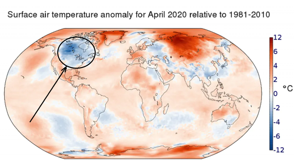
Yup...yet again ... according to NASA, April rings in with North America and/or a significant aspect of that region ( and/or close enough that we can sensibly feel it here...) colder than the most everywhere else... It's really rather remarkable - since 1998's termination of the last ENSO event ( that had any meaning to the atmosphere, by the way...) Global warming insidiously hides and conveniently enables cold trolls in weather-related social media ... haha. Kidding aside, this was predicted by primitive climate models back in the 1990s ...
-
to 10% of the society ...I can imagine
-
all winter, the models corrected everything NW .... now, they corrects SE ... so perfectly 100% wrongly relative to preference. Nice. It's an odd look though. The GFS and GGEM seem to be reacting to an expulsion of deeper tropospheric heat from the SW into/within that 2nd ridge amplitude ... It's goosing it... dumping that warmth into that it balloons, shortens the wavelengths, and that feeds back on/gives the 'manufacturing' look to that trough back east. Not sure that whole thing is right - maybe
-
Yeah but then the GFS starts engineering nor-easters ... It's got a nor'easter out of a 500 mb impulse it has driving straight south along the eastern seaboard - I mean, how does it do that lol. Is it on purpose? I'd say there's chance that's all faux -reasons for thread stalkers to pounce on optimism pending more support -
-
Whatever one wants to call it ... I'm in Scott's camp - the pattern's changed. When it does scale back after tomorrow, when/if/or BDs and/or 'flies in the ointment' etc .. we're not talking about flurries and packing pellet virga exploded CU's ...it's just pleasant. In other words, we escape the madness - and today btw sucks donkey balls. I hate these -10 to -15 day-high douche days of wind and pancake. go f it'self. I don't know what it is... I almost care less about the sun and more about the temp not being a big lubed up rape-dong at this time of year. It's just sapping of will - ugh Warm frontal two-step may throw clouds and showers around off-and-on as regardless of all..boundary perhaps sets up and oscillates prior to that bigger ridge ( if it happens...) later next week but have to take that day-by-day
-
The 00z Euro was pretty darn hot from the western Ohio Valley to the mid Atlantic in that day 8-9-10 range. Of all synoptic metrics in the atmosphere, warm air is the most fragile. Day 4 of the Euro features a weak S/W ular formed bend in the isohypses up over Idaho ? It then takes that feature east across the NP ...Lake --> through day 7. Then, typical for this model at that time range and trajectory, somewhere it finds the mechanical wherewithal to deepen it substantially. That suspicious spontaneity then conveniently engineers a cool back 850 mb plume timed through New England. I don't argue 'a feature'/S/W moving through; I question the Euro's amplitude - seeing as it appears borrowed.. It's not a huge deal though... In fact, the cool back is more like a 'dent back.' In old school Met parlance we referred to that as a "pacific" cold source but it's really a misnomer, as all that means is any cool source that doesn't have a delivery from higher to lower latitude. And then we'll see if that heat in the farther extended is for real/where. I see this all the time .. particularly in springs that are butt banged. When the pattern finally relents, there's a kind of slosh back climate correction ...where a ridge balloons and rattles some SW ejected plateau heat for a couple days. The big dome back three years ago in early July was that. And then the rest of the summer couldn't get hot to save it's ass. Oh, it was sack-sticker humid but but heat and tall ridges were muted. I wonder if this is just predictable climo ...where we'll get a week of dome and then settle back into a NW trajectory drought summer with big heat after big heat ejection shunted S to Virginia ... Then, this deepens in October, snows in November... before Global warming/HC expansion mechanics on a hemispheric scale then f's up all seasonal forecasts for next winter with speed shearing and unrelenting gradient...rinse repeat for the next 20 years...
-
Nah... that's just the seasonality of a warmer, somewhat theta-e richer air mass reflected in the sounding; that will look generically like that until October 3rd when we start heading on back the other way. You know it's funny - half kidding here ... but there's some truth to it - I look at soundings over Kansas, OK....IA and wonder why that whole region of the country doesn't just spontaneously detonate into a massive mushroom cloud as though an asteroid impacted on any given day in early June... Nadda. just streets of harmless CU sitting blithely over 6,000 SB CAPE...
-
Whether some in here realize this or not ... they covet that and hope it happens ...anything to not have warm sun and the general joy and mirth sensation summer brings to the majority - lol... you can include me in that group circa November 1 to March 15 ... I'm actually thinking the 'stretched' L/W appeal and the flatter total wave spacing may help stump that potential some. A lot of BD mechanics requires a sharpening in S/W's as they are leaving that ~ 50/70 region, such that backside NVA curls with more strength ...piling the air up causing the +PP discontinuity and then that air "fills in" the gap on the eastern side of the cordillera...etc..etc... Then doing so over cold Labrador waters and eegh! Anyway, the flatter deep layer limits ( a little ...) of that backside NVA curl, which then transmits less mass to the lower levels and the BDs end up with a less momentum. Not a total mitigation no but we'll see
-
Actually... the more I look at that EPS evolution D6 to 10 there is multi-faceted warm-season entertainment chances, ranging from late tornado season potential in the plains, to a heat expulsion. Usually you don't get both those... When bigger heat/EML's get boated out of the southwest, they are associated with CIN so wide-spread strafing super cellular rake events get suppressed, and what tends instead is toward those giant 80DBZ cannonball-sized hailer, isolated carbuncles on radar that look like they must be drilling for oil but are all 10 mile gated meso with overshooting domes to 70K ... MCS running around ridge rims too... Anyway, if a bigger tor event happens from the lognitudinal wave progression from D6/7 to 10, then it's more likely we have pedestrian early season warmth spreading up ahead... We could have early DP transport despite our green-up being somewhat belated -interesting.. But, here's the thing, the players are in favorable stage-block assignments for putting on an early heat show. At D5-7, there is a lead roll-out ridge that should see the ambient boundary displaced up near the St Lawrence (~) with shallow BDs a potential ..granted, but... Those are not incursion cold/deep trough migrations as the longitudinal flow tendency is ( as noted yesterday ...) instructed by a neutralizing NAO so the flow wants to lift in latitude along the eastern seaboard. But what all this evolution does ... is it sets the stage for if/when a heat expulsion from the SW gets ejected, it would then be naked to swath up in the circulation, and that's just what the D8-9-10 of the Euro operational/EPS mean is attempting to do... So, a big heat departure into the OV/Lower Lakes to NE actually has total roots in the predecessor ridge-roll out setting the stage, and then the second ridge roll-out has captured EML/850 mb super charged air then lidded and running up in the continental conveyor ... Little bit of synoptic anatomy lesson on SW heat releases
-
mm hm ... Weather aficionados falter in their craft if they do not consider the bumps and perturbations running along the interface between these flat/zonal flow ridge amplitudes, and the still vestigial tendency to buckle over Ontario. ... powdered "invisible-to-the-models" backdoor front, just add picnics - No one asked but ... this week was still just about transitioning away from that bombastic cold pattern into a more traditional transition season/climate expression for mid May ... (some extended hints now for more heat) Also .. CC seems to mandate most days are +1.6 to +3 departure, which only get corrected more modestly positive by a raining day that insidiously skews the peril or the world, making the total months only seem more modestly doom-saying. Heh. Oh, the world is so preoccupied by the immediate "Great Cootie Meme of 2020," humanity has forgotten the real extinction signal: the Earth cannot support this species, either way and countless will die. ... enjoy your morning coffees grown and shipped, heated and enjoyed by means and method of profligate expenditure attributed carbon footprinting - The 00z Euro and the EPS mean for that matter, both set stage and begin executing a Sonoran heat release toward the end of the run. Noormaly ...day 10 is nothing more than sip-o-joe morning entertainment.. Buuut, that cluster nailed this presumptive pattern change this week ...timing and amplitude, and actually ..morphology of the super-synopsis from Hawaii to southern Greenland for that matter, going back to when it was day 10, too... So, it may be that it just sees things during present era so... hm - A climo correction flip into heat was hinted on the previous run, too and it's merely more discerned here. Doesn't take a poet to see 90's before the end of the month when balanced against where we've been
-
In terms of sensible weather variation yours up there ( typical for quasi-mountain Met) stands to be most extreme with the changes likely to succeed this week. In fact, Friday's Euro warm punch is deep in the troposphere .. that's 800 mb boundary-pausal look there so you'll be creepin the 60 isotherms pretty high up those slopes should that prevail as is synoptically modeled - if at day 5 usual caveat applies.
-
Ooh... just got to see D9 and 10 ... Yeah, the euro is as guilty with ridges as it is with troughs in that time range, so ...taken for how little that's worth - that does have a climo corrector look to it speak of the devil. It'll be interesting as that sort of flip has precedence ... Something tells me May doesn't end -12 to -16 some how some way. This week's seasonal progression/flip was actually nailed by the Euro at D10 and I've been vigilantly paying attention and it hasn't deviated...now the other guidance is on it...and, the GEFs NAO go positive heading toward next weekend and so pulling the exit latitude of the westerlies up the eastern U.S. isn't a bad fit. Heh...call me a dork, but I'm always fascinating by the 'day' the season seems to take it's biggest single leap - you can do this in November too sometimes... neat.


