Typhoon Tip
-
Posts
44,568 -
Joined
-
Last visited
Content Type
Profiles
Blogs
Forums
American Weather
Media Demo
Store
Gallery
Everything posted by Typhoon Tip
-
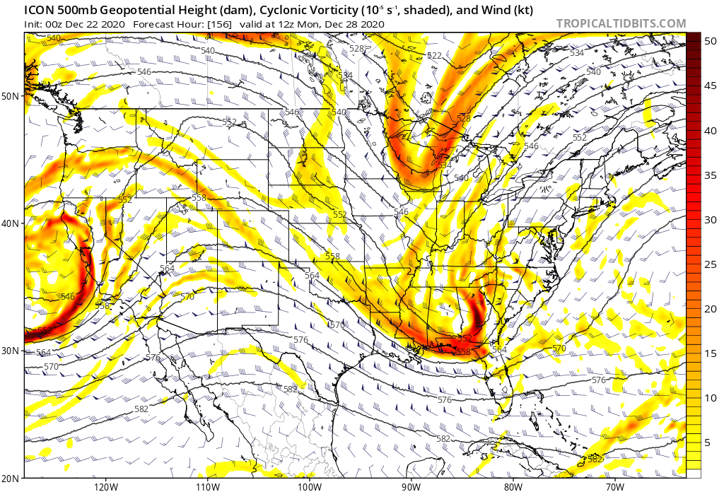
I don’t think I’ve ever seen that before This paranormal ghost model actually succeeds at having a retrograde NAO influence, and a progressive shearing pattern ....simultaneously
-
This is a classic -NAO signal in the NE
-
GFS has shown very poor continuity over the last several cycles/days worth of runs wrt to the N. Atlantic Basin air space. I'm not sure I'm seeing a hugely better return from the Euro oper. either. I've seen standard NAOs, then go west, east ...now ( like this 18z run ) so far S based it almost argues not to be really be "in" the NAO domain space enough to really be call anything other than a ...I dunno, a f'n north-based subtropical ridge out along 50 W-40W lon.. This run actually times the N/ stream to subsume and rock New New England wrt to the Dec 29 scenario; but just keeps the phased result too progressive to really clock the region... Owing to it's instead allowing more progression overall to return to the scaffolding of the entire circulation medium. A bit more down stream backward ply/exertion on the field returning, and that would probably do it - Part of the issue with the guidance is a regime change ... they don't usually present accurate aggregate performance... and then trying to manage that, WHILE delicate phasing on a D7 chart?? mm... The AO is still falling ...tho mop-ended, it may wend its way to a -3 SD mode by D10 ...and as it descends, it's overlap domain NAO is being handled improperly and inconsistently. That is 'normal' as an issue for that domains space ( anyway ...) given to model performance and the stochastic nature therein... but, no teleconnector is usually handled exceptionally well when they're in modality - particularly that one! So the AO falling, the NAO on the move, and the PNA showing longitudinal amplitude along a narrow positive mode ... mm ... I see next week as not having an imminent threat on the guidance, but having one because of the 'synergistic' nature ... which, emergent properties, like 'gestalts,' they can't really be measured as a deterministic product. ... Although the slowing of the wave propagation around 60N, whilst the intermediate stream continues to roll west to east underneath is an inherent cyclonic framework for constructive interference. It is in the correction tendencies that is lending here- fascinating actually.. Ah heck... Probably nothing happens, everyone feels smug, and veracity of this gets muted by faux perception - ...perfect!
-
I think you're all missing the boat on next week personally - never seen such wanton disregard for common/ -textbook theoretic correction needs considering what's going on - but,.. I also think there some good old fashion down home pissed off bad mood controlling the "objective" perspective in here today LOL Yah... 'support group' in full affect - Next week may not parlay ... and of course the "seeeee" parade ...but you'd be wrong - or, right for the wrong reason.
-
Folks need to 'modulate' for/beyond what the models actually show in hard illustration. What needs and 'can' happen in order for that Dec 29+ situation to be a meaningfully impacting winter complexion is not just within possibility, it is imho favored - sorry... Whether that is Chicago, here...or up toward the Maritime it doesn't/won't change the lead indicators... This is a fast/stretched positive PNA inserting S/intermediate stream S/W procession up underneath a ubiquitously slowed/block tendency in the 55 to 70 N hemisphere. Until that changes, neg head takes are about as useful and dependable as D9 Euro bombs on Cape May. Just my take on things. For winter enthusiasts this is an optimistic period...post Xmas through the first week of January - not changing my position on that and in fact the GEFs derivatives from overnight if anything sweetened the deal... This is wintry profiled mass field bias folks ... your correction vector is not pointing toward grousing ( lol ..) you get my meaning though. Prticularly N of L.I. latitude, and relative to a day 7 lead, that Dec 29th+ could become a historic blizzard and it would not take more than 'giga' motions to get there. Would I forecast that now at this moment? Hell no - but we are simply a model cycle at any point from drooling. Just imho - Caveats...? Sure. ... the EPS was not impressive at 00z to me, showing a definitive trend back into a more progressive wave translation/spacial evolution along the 35th to 50th band from mid Pac to ~ 100 W. That is admittedly not going in the right direction. But, I don't believe that is the whole novel ... and the event potential has chapters going into January. And the obvious ... the mean can wobble and vacillate too - Pro: I still see that the 55 to 70N latitudes have slowed relative to the intermediate polar jet latitudes running underneath at the Hemispheric scope. Yeeeah, we can say that's just the -AO but I'm not so sure the philosophy is true in all cases. Not all modes do this. The mass-fields can split the domain such that (say..) Eurasia/Siberia present the ballast positive(negative) ... making the index more notable in quadrature, and the modulation on the pattern may not reflect as well on this(that) side of the umbrella. This appears to be more systemically oriented ...whole scale, and it is providing a "synergistic" emergence for favoring positive feed-back wave interference between the lower Ferral and polar ambient jet latitudes. That's why we are seeing a propensity in the mid and extended deterministic guidance to do this ...whether it happens or not/meets with verification, but I'm seeing this everywhere, where these N/stream SPV fragments are more commonly inducing a S motion into the back sides of interloping S/stream wave spaces out there in guidance et al... Con: A "harmonic" hemisphere is something/aspect we have been having trouble with in recent years, so notwithstanding .. this appeal is bit of a persistence break as another caveat.
-
Yeah I don’t know… I think that’s a first in a series of storms are going to probably bring issues across North America in an era fraught with volatility I wouldn’t worry too much about those inverted synoptics like that at this time range -
-
Ha ha ha oh my god that run is hilarious!… that solution would f’n send a storm induced tidal bore up the Charles river and denude all costal communities right of the face of the planet lol 2000 naut mi of 50 kt sea surface stressing probable sends an order of mag more ISE right into coast then Cat 4 cane, while LA Basin seismograph grad students aren’t sure what their looking at Just Gotta make sure the perfunctory spring tide which always seems to auto magically time on top of those suckers is in play and we’re in business
-
That’s not retrograding… phased solutions tend to move slow but that things motion is going to slowly move east northeast into the Atlantic if CMC… But none of these solutions are etched in stone obviously
-
GFS simply doesn’t phase anything. It just has an intermediate stream S/W there ...but also running thru a rotted antecedent air mass ... Whether the air mass is cold or not aside ... Not surprising the GFS is having difficulty in a phasing scenario at this time range given to its typical biases
-
You’re actually more apt to find that kind of a solution in the spring… Cold air masses modify faster when you get into March for obvious reasons such that the mid-level’s will come down and if you get into one of these phasic atmospheres they tend to run into that predicament where all the cold on the backside coming down with the northern stream
-
Yeah the icon solution is absolutely what happens when you have no antecedent cold air and all that on the backside is basically an 1888 model fold in
-
Don’t think this dual stream connection will break East of 70W

-
I don't know if the GFS ... GEFs are the right personnel for the extended range job in this case. They carry on with progressive bias most of the time. Sometimes it is only nuanced in the 'feel' of their handling. Else, they are outright coherently obviously annoying - that is particularly true with the operational version. As I demoed yesterday, ...we may be on the verge - post Xmas - of an aspect we have not seen in frankly years! That is, a slowing of the W to E propagation of wave spaces at/or/about the 60 to 70th parallels of the N.H. ... whilst the S ( mainly below the 40th ) remains quasi progressive. That achieves two aspects, actually... 1) it pulls the rug out from under the GFS' enabling ... One wonders if we see a worse-off verification tendencies as we get on in time with that period and look forward ...until such time as whole-scale hemispheric progressivity bias resumes... etc. 2) it may not "see" the phasing potential - ...yet, as I type this, the 12z version comes out and subsumes /phases ...not actually too dissimilar what the Euro's cinema gave us on the 12z run yesterday ... It may also be that this is one of those signals, that transcends. ..interesting... I had previewed the post Xmas favorable pattern with this annotation, just to give an example of this expressing in the runs: ... At the time I was using the Euro to step -wise take the reader thru a perceived analog, ...not intending it to be a formulaic outlook; I'm half thinking to fire up that thread, though. Perhaps head it off with this discourse, because this learning tool does couch in it storm system - I probably should have the ballz to come out and say that... This is rooted in other aspects supporting. The strengthening negative AO phase is almost getting out of hand at CPC ( lol ) ... with a mean nearing -3 SD; although mop-ended ...every member stays negative toward and thru week two, with a few errant ( so it seems?) members unlikely to -4 SD! Meanwhile, the PNA teleconnector failed to go negative even by a little, last week. It stayed positive, and over the next ten days to two weeks -worth of outlook at CPC, it oscillates to relative values above 0 SD ... This creates an implied cyclonic motion ( in the relative sense ...) in the mid latitudes that is synergistic favoring constructive wave interference scenarios. You have to think of in outre form, as gestalt - and that there is a virtual positive (negative) for cyclonic (anticyclonic) tendency. Now ... positive. Atmospheric events in real space and time passing thru ...will "tend" to manifest positive (cyclonic) interference. It's not just true here... Europe/Erasi and the WPC all probably have this favorable look.
-
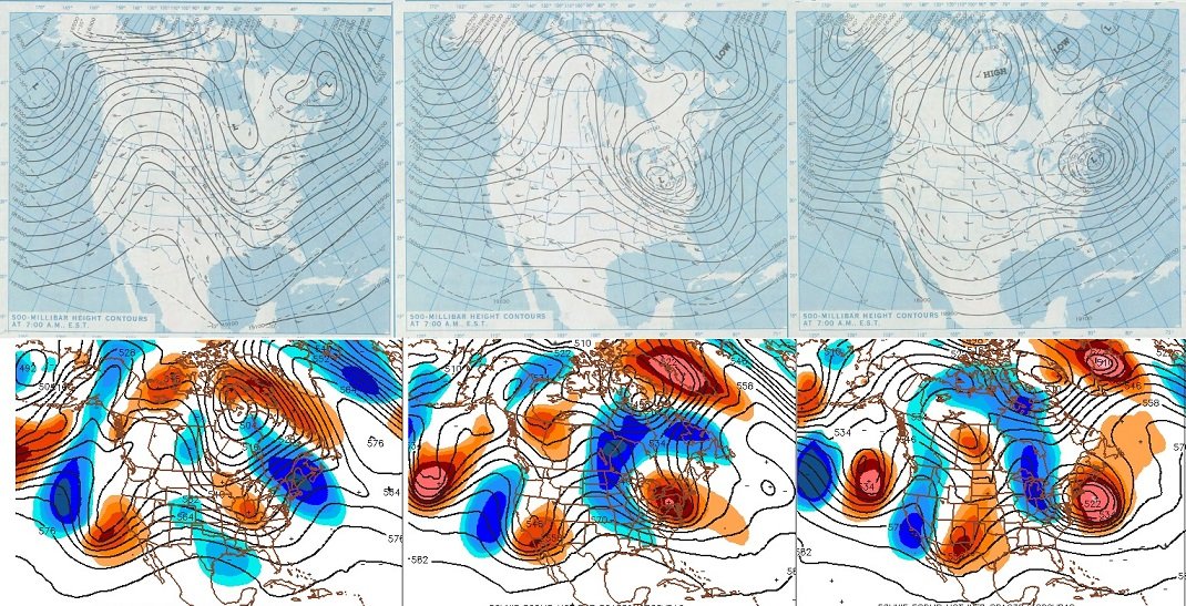
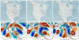
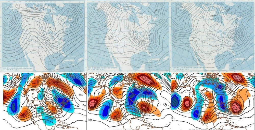
1978 analog ...subsume potential: I spoke about this yesterday and how the post Xmas period through the first week of January had begun to exhibit a relative stream cyclonic motion between the 60/70 N and 30 to 40 N latitudes, and that this "might" herald this sort of risk... viola! Today, we see this as though the models got that memo! Whether this exactly verifies is obviously remote at this range, but this is just to point out the utter powderkeg that is presented when you have this sort of 'hemispheric phasing'/ multi stream harmonic that is - rarefied these days! - whole scale constructively interfering ... Not something we've seen a lot of in recent seasons... But take a note of the last panel on the right, 1978 compared to the Euro ( which the bottom row represents...) and peer up toward the D. Straight and Greenland... the whole scale quatra hemispheric scope of the N. Atl back through the eastern Seaboard and the Maritime of Canada are like a poor man's plagiarism... pretty amazing actually..
-
This is a trick question? Because for anyone located in Westwood Ma, none of these matter - all dogshit - hahaha.. kidding, I think the take away is that all major models and their ensembles are reserving that space in time as prone to significant events. But I get the humor in asking the question
-
Throwin' some buns into the fray ... ... there is a little known teleconnector that exist between the British Isles and the NE U.S.... tending to be positively correlated - such that what is happening there, tends to happen here ( or within geographical reasonableness NOT to be stoned for merely advancing the impertinent gesture lol - ) ... heh, heh? who's with me - seriously though, there is. The reason for that is basically just geometric, and the curvature space of the planetary system and normal R-wave distribution coincidentally puts ridging and trough concurrently at either ends of the Atlantic Basin. You know ... so the pattern conducive would also "precipitate" in such a way as to make people groan for making that pun there on purpose because it's fun to annoy them - No but NAO "possibly" emerging ( per GFS operational most guilty ) is an interesting aspect in this... It's like the model is sniffing out; yet at the same time, we can see a supcon of tendency to retrograde the higher latitudes before the NAO really manifests ... And it may be more than sensing this as 'synergistic', because the AO is negative ...and though the mean (GEFs) does blow up and mop end out there into week two, the mean is still heavily negative... So, I just wonder if the speedier flow/plague is interfering with the EPO and NAO's abilities to foment blocking nodes, which given the former seems we should really be seeing more of that. hm. As far as the SSW ...not sure I agree with that... one thing I have noticed about the GFS handling of the thermal/sigma levels out there in time over the last several seasons is that regardless of whether one occurs or not, the model loves to fire off huge hot pulses in the 10 to 30 hPa levels nearing 300 hours+ ..or even D10's... It could be like placeholder in the physics; sort of like it's always prone and the model is sniffing that out, but the trigger fails to pull - We'll see... The QBO is also out of phase for SSWs .. but that's not a deal break either
-
that "hesitation" you and Bri dawg noted though ...could be a hint at where this is heading... in simplest terms: yes a full phased multi- stream latitude screw job can happen - but it isn't favored given the longer termed hemispheric behavior. which ..considering the latter - I don't think is endemic to just some present pattern. no way - that's been doing that progressive shit for decade or more ...regardless of index mode, land air or sea or in aggregate therein, too - but, anomalies relative to anomalies nest at times.. we'll see
-
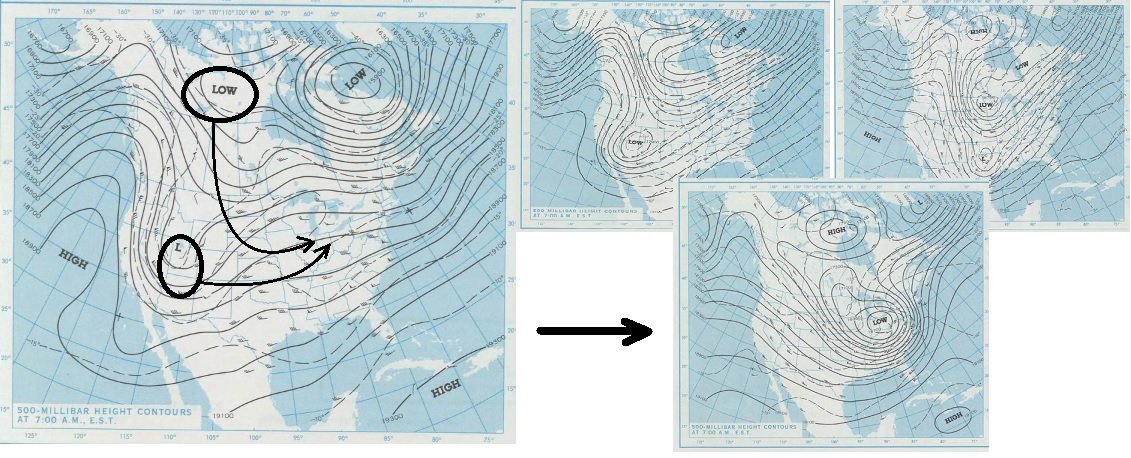
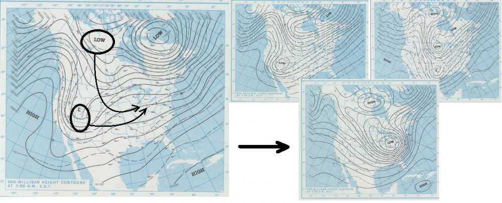
I am not saying that above post/annotation effort is about to redux... but, I am seeing that same relative cyclonic motion between 60-70 N vs 35 N ... at super synoptic scales - and that is presage to vulnerability for this sort of subsuming you see in that idealized example ...about a close to perfect as a fluid medium can ever achieve - jesus... I lived thru that ..by the way, over SW lower Michigan ... no, I've never seen anything like that since - sorry... I've lived out here in snow storm conceit Kingdom of legend and gods for over 30 years now and have never seen anything compares to that physical expression that resulted
-
-
In fact ... I can see the nuanced 'hints' in the GEFs individual members, ... and even the operational runs ( like the GGEM) that the period between Boxing day and NYE has a subsume characteristics about it... That's basically when the lower Ferral latitudes and the upper Hadley latitudes are moving cyclonically relative to one another ... That means, the southern stream ejecting features along ...and the N stream is either tending to or outrightly in retrograde. That's precarious for phasing ... The western ends of or in whole, SPV fragments dangling by and by ...in wait, and these lower latitude or intermediate ( doesn't have to be "S sream" per say even) stream disturbances "entice" them to crash south... But they are mechanical juggernauts and when they due they usurp and devour the S wave's dynamics ...using said wave's moisture input and ... BOOM!! There are countless analogs to describe this sort of phase - I'm surprised there isn't phase labels for that matter. Like, we have "Miller A" and "Miller B" and hypothetical M C's and D's therein... There should like American Weather Forums A and 'Forum B, phase types.. lol. Because you can have open wave, two stream phasing that is different than the classic "Cleveland Super Bomb", or "Feb 1978" - that year was an absolutely fantastic year for subsume type phasing... The 12z GGEM is missing the southern component to the above model, else it would be a classic... where's as the GFS seems to conserve the speed of the flow by staggering an N stream backside insert at an usual trajectory .. Obviously, these are all subject and highly likely to change...just that when the background canvas looks vulnerable, the operational concept darts tend to hit more targets -
-
Yup ..it's pretty clear this is the next major player/signal to watch for ... roughtly 26th thru NYE ... Much too early to thread it out there, but this signal has been pretty obvious as a PNA rise, ... "pulsed" west base NAO tandem for about 4 of 5 days frankly. I suppose in the conceptual sense, the lakes cutter and warm sector intrusion has the climate history of preceding the NAO ... transient or more ...as a leading phenomenon to the mode transition toward negative...then if the PNA does roll up underneath ... usually eastern N/A's mid latitudes wind up in business for cold storminess - Back in the day, I would have started a thread for this given the signal as is.. .but, it seems there is a general culture to wait things out more -
-
Mm... I'd say that belies the extremeness of that set up though - not saying you're intending to do so...so take it the right way. I'm just sayin', those sort of synoptic "upside down" transient ordeals taking place in highly meridion amplitude, ..yeah, sure - but it is the scale and degree of the dipole its self that is whack here - Thing is, ...the models are not going to show something that is "physically impossible" - I mean... forecasters in AFDs may float that sentiment in passing here and there, but they are more droll when they do. Truth be told, if the models ever did that ... they wouldn't be a very effective/trustworthy tools for representation of geophysical process - could they? no - It's really a matter of whether the perfect parametric management can be maintained in time, without permutation, to allow the "ceiling" scenario to actually play out - In this case, having 63 F at BED MA, while it is 22 F at ALB - is about at the threshold of what can set up at this lat / lon, on Earth ! ...and being 6 days away, that's a lot of time to succeed without said anything getting involved that will hose that set up...
-
'Course... there's the other school of thinking that dramatic variances are favored ...and verifying world -over at increasingly alarming frequency so ... perhaps going from 62 to 27 in 20 minutes is just our region doing going through a version of the new course in climate
-
I would really rather not enable the grousers by offering any kind of commiserate philosophy ... buuuut, yeah - I do see that 'positive' tilt ( code for shearing - ) tendency as having more plausibility as a correction in present era. Some of us ( Will and myself....etc) have been back and forth on this the last several days ... how the background long term trend leading, doesn't support these sort of hugely meridianal ( N/S) structured, multi-stream phased scenarios so well... Paraphrasing...fast flows don't lend to curved trajectories - the wind obeys the same laws of centrifugal forces, and the faster the flow ..the more the "circles" open up - it's just like trying to zip around an off ramp at 80 mph... you'll likely leave said off-ramp tangent to the curve ..lol. Anyway, there's like a magic threshold of wind "in stream" velocity, relative to the curved surface, and if the wind needs to mathematically exceed that restriction the models will open up troughs... In this case, it looks - conceptually - like the models are right at that threshold.. And seeing some hints by these higher resolution runs already that are trying to do so, "might" just be an indication that the Global -scaled models are just not close enough to the system where their resolution can "see" that limitation - ... interesting stuff if one has no life hahahaha... So I'm not completely sold on a v-cut tuxedo trough in the nation's Lakes longitude that dips to the Gulf where there is a bulb of -3 SD hgt anomaly dangling, then rising up to tip over Baffin Island at exit just yet, when the wind going around it is so at an anomalously high velocity - It's funny ... folks see a D 7 cyclogenesis that is hugely perfect and there is all kind of neg-head banter which is fear-bargaining psycho-babble posts miring the mood down... Or, you get this D 7 type of construct and everyone's convinced it is going to happen ... affectedly miring the mood down ? got it! no win engagement in here... Sounds a bit like a persecution complex if you ask me - lol ...
-
I see the 'support group' is in full-affect this morning, huh - lol... Jesus, still seven days away and why is this iron clad, immutable again ...? no other choice, right ?? Sometimes it really is hard to ignore that this "hobby" has evolved to be less about storms and events themselves, and more so about the modeled cinema leading. I'm almost willing to hunch that the storm itself is less important to some even ... rather, trying to make sure the cinema's story in the days leading doesn't send you through disappointing chapters. Ah... I guess a story isn't any good without a protagonist, huh ? lol - I'm intrigued by a signal nearing New Years -