Typhoon Tip
-
Posts
40,582 -
Joined
-
Last visited
Content Type
Profiles
Blogs
Forums
American Weather
Media Demo
Store
Gallery
Everything posted by Typhoon Tip
-
Summer 2019 New England Banter and Disco
Typhoon Tip replied to CapturedNature's topic in New England
https://www.aol.com/article/weather/2019/07/01/freak-hailstorm-buries-guadalajara-mexico-in-3-feet-of-ice/23760878/?ncid=txtlnkusaolc00000992%3Fncid%3Dtxtlnkusaolc00000992&fbclid=IwAR2a1CRnvhFKzuy-6hSNmAOIP7TdAPzkP1O7LcEEN-Hiuta8pg81-f1i35o# -
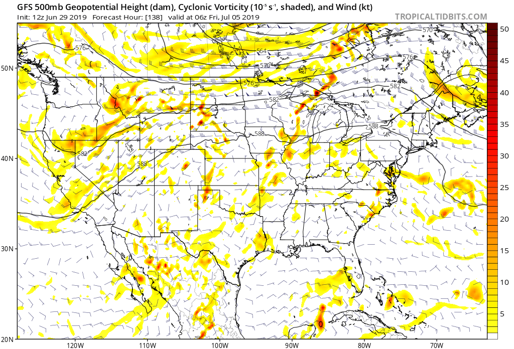
-NAO does not correlate the same way for New England in JJA btw - ...Brian alluded to this, and if you look at his product's details you can see how that look could supply us with plenty of very warm potential ... also, MCS/convection chances. The 582 dm isopletch is not usually how you run cold air through here. And probably of more importance, have the mean that high means there are members that are sweltering in there too. Re the D10 Euro,... the EPS and Euro rarely deviate that much so I'm not sure ( but suspect less confidence ) in that one model cycle meaning anything, seeing as both broke continuity to flash that look. We'll see if it has legs but ... one may not be so quick to pounce on a look merely because you want it. Just sayn' ...
-
GFS is either going to look very good ... or, not very good this time Sunday when looking back at MOS performance this week. Haven't seen the 12z Euro operational run ...but the synoptic evolution for the week across the 00z run painted a hot picture for the 4th and 5th. 90s those two days... Now, I didn't see any 'cloud' products from that model - in fairness to debate, it may be muting temps. However, with amplifying mid and upper heights and WSW component, the climo on those parametrics is usually less ceilings/more insolation. Contrasting ...the 12z GFS MOS is cloud almost at all times from late tomorrow to Sunday morning.. I think...well, wonder if the GFS is having a problem with DP and huge theta-e loading that's trying to steam bath its way up into the NE as the week goes on? The GGEM and the GFS both doing something bizarre over the weekend, ...they are morphing what appear to be 'heat lows'/thermal troughs along the lee side of the Apps and the coastal plain up to SNE, into baroclinic lows... This, with zero baroclinicity between Buffalo and NYC... All but 972 to 976 dm thickness everywhere. It's also got QPF saturation in that same area in that torrid morasse. I'm not sure I buy any of it.. The GFS MOS has collapsed the high temperature prospects from 90 and 93s to barely limping passed the mid 80s, and fact, fails now to tough 90 at all in some cases through this Saturday...with 850s over 18 C and 570s thickness and 588 ridge cap... mmm... weird. I'm interested in seeing the Euru here...
-
Summer 2019 New England Banter and Disco
Typhoon Tip replied to CapturedNature's topic in New England
Meh... some years ... months are different - shocking revelation! June last year has zero bearing on June this year. If anyone has a modicum of philosophical awareness, it may occur to them that the comparison really has equal value to that: Zero. It's tantamount to saying June last year is not June this year - right...got it. Thanks. We had a temperate June ... yay. While most of us in here discussed that as a very likely plausibility ... back at the end of May (btw), I guess now we are stunned that June was banal for heat? I guess.. Going forward, July very likely will start above normal. How much exactly remains to be seen... But, I could see the first 1/4 of the month finishing solidly above. -
Having said that ... the 00z Euro looked pretty damn hot for Thur and Frid this week.. Just going by the synoptic layout of basic parameters... looks like 95 is doable those two days, and probably Thur night would be one of those 80 in the urban center type of deals. The American models are ..as usual, running out and contriving gradations to temper things if they can't see them actually in existence ... it seems like - it's figuratively as though the modelers embedded permutation genesis algorithms deliberately to f'up heat. The GFSX MOS is 90 or 91 for four days one cycle, then 85 the next... I mean.. I'm not just complaining for the sake of heat mongering... I wonder what this is going to mean in the winter with this model.
-
The trend to dampen the mid month cool down was both expected ...and prevalent in the 00z cycle... It's subtle but there - It may not get 'hot' per se...
-
LOL ...
-
So far this day his isn't materializing the way I had thought it might, yesterday, when looking over stuff. I was under the impression we'd dawn with fair skies, check ... but, after that? Nah...wasn't seeing this pin-wheel entering NE NY as being so aggressive that it's transforming this into a different synoptic reality... One such result ...too much cloud debris rattling around in its midst ... The column is really closer to being baroclinically cyclogenetic ... evidence by multiple sigma level gunk. Yesterday I thought we'd be warmer in the BL through noon or so, with more sun ... maybe a streak or two of alto strata/cirrus, with horizon toes poking through. Not this inundation shit. No heating. Granted it's still cold aloft. If we do get more sun ... maybe.
-
Well ... it must be comedy hour then - The Socks presently are a victim of ( stupidity + arrogance )/ 2 = struggling to keep it above 500 while having offensive roster talent capable of repeating. If their pitching roster/team is purely a result of the GM, he is D. "Dumb"browski ... but, I wonder if his bosses salary-capped internally. Add to that stupidity, A. Cora comes off as having an over-belief/arrogance in his ability to run games, while mainatining a dearth of valid pitching... Why? Either because he won it all last year, or... he's covering for the former back-room circumstances... Either way, he'd be a moron for setting himself up that way. Those two factors are ruining this season ( to date) and probably will go on to ruin this season, and waste a good offense.
-
According to the GSFX MOS.. it's projecting marginal heat wave prospects N-E of roughly EWR ... spanning multiple sites. What's interesting, albeit tedious, is that the synoptic complexion ( 00z ) was/is the warmest 'looking' from that particular model ... going back several cycles. Yet it's machine interpretation chooses that cycle to nick temps off. Otherwise, status quo. Looks like very warm ... hot for some tastes, while quite plausibly failing to register a heat wave. I was just looking at the 2-meter progs on the GFS and it comically puts up 90/89/91/95 ... seemingly on-purpose, for ASH. I gotta figure at this time of year the 'correction vector' is pointed upwards; we can almost perfunctorily add a degree to all these. Man... if it's not rasping ridges it's shirking derivatives... unbelievable. We could be sitting on the surface of the f'n sun and this guidance will have 6,003/89/7210/6534
-
You work outside ...?
-
On the fence. We'll see if it has legs... I've seen that since April in that range - more or less what I was talkin' about. But the look then goes on to a warm complexion, just falling shy of getting hot - and by that we mean fairly and objectionably > normal. It seems we're not slated to historic heat... but "perhaps" the models are seeing what reason is causing banal/uninspired summer warmth by over doing it on troughs in that range. But the summer's young, and there's certainly time to get a bigger heat plume going than we've seen. The 12z GFS is now on board for low end heat wave this week to ring in the month...
-
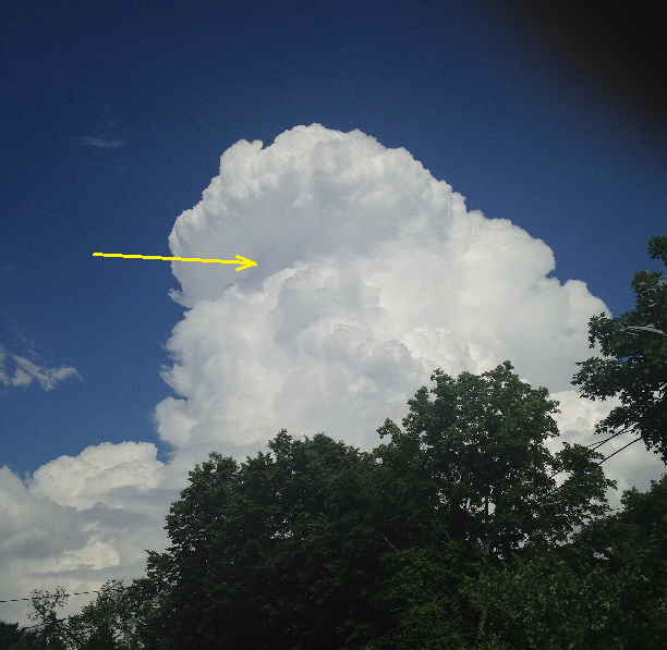
It was just like that ..but it was bright enough to be visible on the sun side of a back lit CB ... I ran for the phone but ... alas the flaring had ceased by the time I snapped this image off - The yellow arrow is the approx region where it was flaring off the top of the lower turret near the interface where it gets lost punching into the top region. It followed theoretical behavior to a tee...it was glowing in there, then there was bolt of what looked like it might have been cloud-to-air and that seemed to trigger the flare to morph ... it did that a couple of times, too before the whole thing stopped. This guy was putting out distant booms as it was moving away toward the east, and it was warned on the N side of Boston... Wow- today was hugely worth the analysis in my book jesus christ.
-
got to see my first Crown Flashing phenomenon
-
yeah ... was thinking pulse being our fun-show ... we got some velocity shear mid way up CBs as they were leaners when first glaciating... but below 10k seems unorganized. DP busted high east of the Berks ( as far as I can tell..) and that's probably given us a CAPE boost
-
warned ... told ya to watch that cluster -
-
You can see those towers over my area of Middlesex CO on vis imagery ... those are close to cutting through - wouldn't shock me if those take off for the N. shore...
-
averaging 83/70 around the Davis' within a couple clicks of mi casa ... The sun popped out for a jiff about 30 minutes ago and that seemed to trigger CU eruption. Dark bases spread over head out of no where. I can also seen towers N-W...
-
Seems to be reflecting in the 12z GFSX MOS ... EWR/BDL/FIT are officiating wed-thur-fri... 'see what the Euro throws at us -
-
Why ... I'll be ... the 12z GFS run thrown' less rocks at the skull of the ridge -

-
https://www.spc.noaa.gov/products/md/md1298.html temps are 78 to 80 pan-wide and the sky's trying desperately to open more. But ...their reasoning is contained... It echoes what we've been talking about re the sun/limitations...
-
Believe me ... I know! and we like to know from which direction the dildo is flogging ... I really think though, that pre fropa isn't our problem ... we need this ceiling contamination to wane out... There's time..but we gotta do it by 2pm or it doesn't matter whether there is a trough pre or not -
-
Keep in mind also ... you could be getting fooled by the fact that we had 4am to 7 am rains showers/thunder traverse the area, and that may be conditionally hiking theta-e now that the sun is finding it's way more to the Earth; evaporation and limited lower BL mixing ( as noted by the weak wind fields ) is may be faux elevating east of the Berks.
-
Man... you just won't give up on the pre-frontal trough mantra I dunno - I checked out SPC's meso analysis and there is a broadly defined trough structure but emphasis on broad... That means not well defined. The gradient still also looks weak ... It's hard to separate that look, which is -btw- is entirely normal lee-side of elevation fluid mechanics .., from that same time of structure becoming an evacuating moving object in the atmosphere.
-
It is improving... We'll see... I think the convective temperature is in 85 to 87 range - but don't quote me. ...