Typhoon Tip
-
Posts
40,584 -
Joined
-
Last visited
Content Type
Profiles
Blogs
Forums
American Weather
Media Demo
Store
Gallery
Everything posted by Typhoon Tip
-
...too small to read; won't load when clicking
-
Lol.. Impossible Burgers!
-
"all" ? No.. of course not. - nothing in nature is all though... > 50 % ...? I'd be willing to be the farm. That's all that matters. If the ballast of negative impact is one's fault... it's one's fault the total system is f'ed. We cannot be lawyers and weasil our way out of culpability to this thing and crisis, because winning that debate leads inexorably to a very bad state of reality for the World. ... I've read enough advance theoretical, peer reviewed papers, ones that frankly... fit theoretical meteorology, elevating atmospheric gas constituency that are more proficient at storing thermal energy, causes increased capacity for WV in mass ...in turn.. rain, snow.... elevated lows to name a few. form ... to know that the noted increase in nocturnal lows all over the planet, as well as statistical rainfall anomalies all over the planet... are not happening because of ENSO, AMO...etc... These WV-related elevated quotients are happening regardless of ENSO warm or cool phase... AMO was positive when this GW curve hockey-stick, and now...it's flipping negative and we still hockey stick... weee... So it's true in both cases... Seems there is a knee jerk tendency to refute this GW ... when in evidentiary, there is growing data base of events that are mathematically connectable to the spectrum of consequences being observed... It's been a popularized mantra, then codified by populism narrative... But I digress.. .sorry. Anyway, there's definitely a ' counter-culture' to do so. This was clearly put into motion back in the 1990s. The forefathers of the science ...man, were they ever neolithically incompetent in how to bring the concerns to the light without offending people's way of life. If they had just not doomed everyone then, this row would have been avoided - I think.. . Because of that heredity...we are going to be suffering no-sayers WHILE humanity's bus is careening off the cliff of what probably is a directly related cocktail of cataclysmis that ultimately force population correction - that's the Sci fi dystopian extreme, granted... But, you know... if it does... all of the off-set "plausible" denial statements will be etched onto the headstone of human kind like the names of fallen heros upon the Vietnam Memorial monolith down in D.C..
-
It probably is ... just not February - what I mean by that is that it's the same mechanic for all intents and purposes... We haven't set this sort of circumstance up in the winter in quite some time ( that I can personally recall...) but... a fresh cold polar high establishes a cryo flow over the water that is near saturation... and that air mass is forced to lift over land and you get these bonus snows... They look like stationary blogs in winter though. Here they're more cellular sorta lookin' on radar. Only here, they summer taxing misty rains.. I remember ...I think it 1993-1994 ..we had that quite a bit in and prior to winter storms. The storm its self may have been a nickl/dimer but we got like 12 to 18 hours of brochuring when the polar high wedged in before the storm.
-
I'm being partially tongue in cheek ... They may be fine. If you have information privy to the instrumentation that is real and reviewable, by all means. I just recall back in college that all those ob points were rounded - if they have some decimal equivalent improvement in finite measure techniques, awesome! Otherwise, I've seen too many obs vary at random times over the years ... like 60 degrees at one, and 110 degree directions at the other, during easterly gales... when a focused jet should have them all be locked at 90 ... That doesn't inspire confidence when one sees that. Maybe things have improved...
-
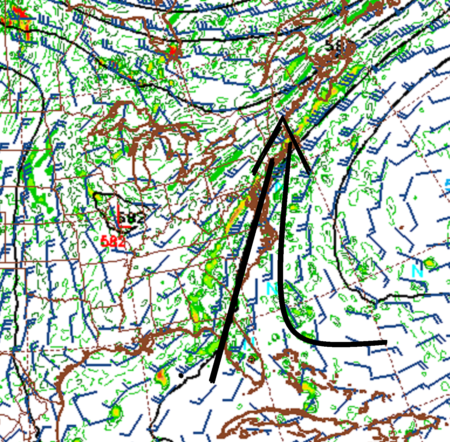
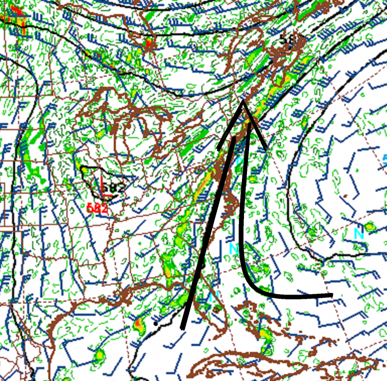
It look(s)(ed) like we did get that secondary acceleration behind the primary cold front.. It was evidenced on satellite - I haven't bothered with the tedium of ASOS wind obs as I don't trust 'em anyway. It's probably too sensy to be detected by any rounding schemes ... and/or fractals that would love to avoid wind cups deliberately to make this look wrong. But it did look like it punched in shortly after dawn, as an under-cast perturbation that rippled in an arc toward the SW... ----------------- NAM's overnight machine interpretations don't get it hot on Friday...well, relatively speaking. It gets it 81 to 87 depending, with a much slower turn around of the regional BL vectors during the day compared to the global models. On the surface *( pun intended...) that doesn't exactly offend the better reasoning ... it's very high resolution may be "seeing" low level resistance better - or not. I've seen it fail in this but, this is a weighty dense air mass invading..It's not just BD... it's actually mostly straight up summer cP air bubbling down, that's mixing in BD/GOM type hybrid. Anyway, the Globals are selling us the idea here that said bubble high completely normalizes and smears out into the evolving longer term pattern, and establishes a deep enough return flow that we tsunamis OV heat all the way to Boston Light sun down tomorrow. I'll give the notion of a late high a nod, either way... but, it's going to be interesting to see if the Euro/GFS are right about 92 to 95 outta this turn around tomorrow. Should the NAM prevail... heh, can't say it's a shocker. The other thing about the NAM is that it's convective sequencing may be also effecting it's solution for heating potential.. I'm noticing that in addition to being somewhat slower to homogenize the surface pressure pattern...it's flaring old MCS garbled gunk again over southern Ontario nearing 18z and races it east... It even seems to start materializing what I suspect is a rain cooled assisted cool front signature in the pressure pattern associated with that... The Global runs don't do this.. But, the NAM may be contaminating the sun's ability to heat things, too. Just sayn'. ---------------- Saturday is also not that hot in the NAM MOS. Now... as your eyes roll around (and rightfully so...) keep in mind that it's DPs of 78 and native tendency NOT to mix vertically outside of convection, may be limiting NAM BL expansion. It does seem a little shirked that 22 C at 850 on a perfect west wind and very low cloud level RH ...would end up less than typical BL depth/adiabat... The GFS, on the contrary, does that too much as a general rule, and therefore, sky rockets barotropic air temperatures at the mere sight of sun-up insolation. What's interesting is that the 'X MOS DPs are still running 77-ish ... so that's confusing.
-
GW ... period
-
TODAY: July 17th-18th - Storms/Severe/Flooding
Typhoon Tip replied to TalcottWx's topic in New England
mm... shear isn't right .. .but who know - maybe terrain assisted.. That cell south of Barre appears to have split - interesting... southern one might be interesting soon. -
Yeah...some substantial MOS busts leveled before we're capping here.. Vills taken over ... we convert to severe/flood thing the next several hours.
-
TODAY: July 17th-18th - Storms/Severe/Flooding
Typhoon Tip replied to TalcottWx's topic in New England
This has training written all over it ... someone's liable to get water-boarding -
TODAY: July 17th-18th - Storms/Severe/Flooding
Typhoon Tip replied to TalcottWx's topic in New England
The one coming in south of Pittsfield is turning right -
TODAY: July 17th-18th - Storms/Severe/Flooding
Typhoon Tip replied to TalcottWx's topic in New England
Mushroom caps ballooning all over satellite central Mass to eastern NY/PA/nj -
GFS/GFSX MOS' have come around to hot Friday now... 96/74 at FIT ... Still has the 101/73 on Saturday ... My guess is what Chris and I were discussing the other day needs to be considered. And it has to do with the GFS heredity not yet properly handling BL Meteorology. It's may be overly mixing the column and allowing the temperature side of the Equation to rise to far. My hunch is it caps around 96 but with 77 type insanity... I mean, splitting "airs" there...right. 96/77 is probably about the same as 101/73 ... Basically a good day to leave your dog in the front seat of your rural 1984 Massachusetts chevy pickup truck that has a back gate wired shut - Also, has 96/73 for Sunday
-
TODAY: July 17th-18th - Storms/Severe/Flooding
Typhoon Tip replied to TalcottWx's topic in New England
Welp ...there goes my bike ride ... -
Nice gully flooder out near Springfield..
-
Instrumentation ... every NWS site is substantially lower than just about every personal station tied into social media platforms... By a considerable margin, too. There's a sensible difference between 90/71 vs 90/77 ... I was outside here at lunch and we had to bail on the patio idea at the office - too unbearable after just 1/2 hr ( funny ...we were complaining about the office being too cool ... wham). Feels like the DP is higher than 71 ... but that of course don't mean diddly
-
So far... NAM MOS has busted 2 to 3 F most sites around SNE
-
meh ... GFS is just doing the same thing, oscillating backwards again... a run or two in the future, the other way. Highly confident of that happening about every second run, up or down. You can tell it's going to do that in the near term just watching the behavior of it ridge handling... If it's slightly flatter with the ridge, the mid range is aggressive with troughs ... Then, if the ridge is slightly stronger...troughs are overall less incurring to mid latitudes. It's been clad every time! Oh... flat ridge.. .here comes the YUP. It strikes me as large scale 'sloshing' error - for lack of better description. Where the whole thing is oscillating some 6 dm heights up or lower everywhere. That's a bug in the algorithms - when the whole thing moves en masse like that... up , then down... unilaterally, it's not likely real. More like an emergent property of a complex system - almost like "giga" motions in mechanics.
-
MD out ... watch possible.. TCU now...
-
Does look like SPC has rehashed the slight region a little farther N... now up to the VT/NH border... "I think" it was down near the pike early? ... anyway - sky has opened up markedly from the southern tier of NYS east through Massashusetts and temperatures are responding with rapidity. Should be mid to upper 80s in the interior south of Rt 2 by noon and probably if we don't set off convection sooner...headed for 90. This may actually be a modest sun bust/positive
-
It's angular in orientation. "the PIke" is west to east...? It may be warmer in southern VT than NE CT tomorrow, both of which will be cooler than NYC .. more like that. Just keep that in mind... and also, the cooler momentum/secondary push could come back ... It's just that specific aspect has backed off for the time being - that's all. But we'll see ..it might be able to get to 80 out your way... A DP slide back into the 60s is a good guess, too
-
Yeah.. most likely ... A moment ago I was noticing some changes in the recent complexion as offered by the NAM... In some rare scenario... a model might over do it on cooling. But as a general rule of thumb, if there is ANY contention at all within the orbital space of Jupiter, to cool eastern NE in an otherwise hot pattern... reality will destroy the entire universe to get that to happen. We mustn't forget that ..ha. Scientific of not ...this frustrated axiom exists for a reason -
-
12z NAM's lost the "BD" flavor to this thing for tomorrow... opting for more of a mere wind response/change do to the trajectory of the high pressure initially settling through the area during the day. In fact, keeps the winds at Logan at or < 15kts post the switch. This is different than prior runs ..particularly those prior to 06z's cycle. Those runs showed a wind shift to NW followed 6 hours later by a clear and coherent ENE pulsed acceleration to some 20 to 25 kts of sustained marine modulated cold ... That acceleration was the 'hidden' BD. There's less of that now. That secondary acceleration is absent from this run. It turns the winds onshore and as said...keeps it light. In fact, ALB's 2-meter may be 27 C tomorrow afternoon ...and with only 15 kts coming into the coast, I wonder if 24 to 26C may be common along the eastern Worcester Hills. Again ...prior runs implicated 64 F with strata and mist into those regions. Interesting. We're still getting the torridity interruption tomorrow... It's a matter of the details offering more or less within the confines of all that. Right now... the 32 km/meso seems to be pulling back on the cool side/momentum for now.
-
Nice Bahama Blue pattern here at D9 in the GFS ... GGEM suggestive too - ... But the Euro's in a different zone with semblance of rebuilding heat wave paradigm.
-
It's not going to be 'sunny' ? hope that's not the impression there should be some sun intervals during the mid day... 'nough to goose the temp and perhaps build SB CAPE and aid destablization... as latter concerns.