

Typhoon Tip
-
Posts
40,593 -
Joined
-
Last visited
Content Type
Profiles
Blogs
Forums
American Weather
Media Demo
Store
Gallery
Everything posted by Typhoon Tip
-
You've been above the theta-e axis in the means... that would be my guess... I dunno - the NP-Lakes-NE regions have been almost collocated with the summer polar jet the whole f'n way ... Can't seem to flop convincingly on one side or the other.... It's been a -AO summer - so says the numbers. But, I almost wonder if the polar jet stayed active at a lower latitude mainly because S of ~ 40 N there' has been a subtle positive height anomaly everywhere... Meanwhile, more average heights abound the 50th - that would enhance the westerlies in between ... and the AO may be more like "defaulted" S in such a situation. Either way... the jet nearby has entrained drier air into the N Lakes to NNE but probably not this far S. Your region may be just far enough polar ward of the core that the deeper theta-e is ablated from getting that far N ...where's as ...we're getting closer to the source ...but no so much so that we are convincingly hot - at least not by day... It's been weird. A top 10 hot summer with only 12 90 F days - ... that's a lot of 88.4's ... but really, it seems this has been a nocturnal summer. Last night night was surreal down our way... it was just at sun set... The sky rendered to that misty gray-blue of dusk, and the air was utterly still... It was 80 F ... What was so odd is everything about that setting screamed 62 and hemorrhaging heat to space... 80 F That warm sultry stillness under such open sky -
-
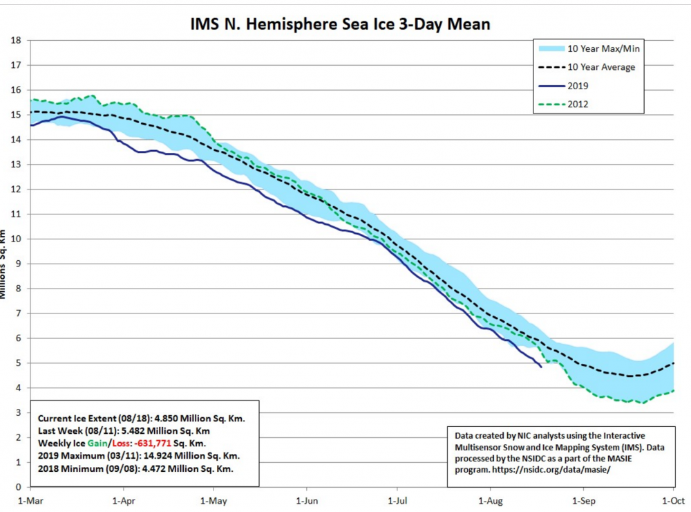
Okay ... .this is just quick and dirty Web goop but... IMS is being used by the National Snow and Ice Date Center ... IMS Daily Northern Hemisphere Snow and Ice Analysis at 1 km, 4 km, and 24 km Resolutions, Version 1. This data set provides maps of snow cover and sea ice for the Northern Hemisphere from February 1997 to the present from the National Ice Center's Interactive Multisensor Snow and Ice Mapping System (IMS). That's what's confusing ... if we say "...2nd lower behind NSIDC" ( which I'm not trying to refute...) but this statement above says they are using the same IMS tech, and said tech is showing 2019 has been lower than 2012 the whole way... that's a discrepancy.
-
I have a question - which may be fairly 'duh' but since I haven't been by those other sources ... Are those more comprehensive than "sea ice only" ? That IMS product is sea ice only ... And also, just fyi ... the IMS product comes from NSIDC - we may be able to put the pieces together here on why the disparity. It's gotta just be some dumb product thing I'm not seeing shit
-
2019 ENSO
Typhoon Tip replied to AfewUniversesBelowNormal's topic in Weather Forecasting and Discussion
I don't doubt there is/was relevant science and/or postulate content that predates the shenanigans that go in here I mean ..it's a public forum ... to which a social media outlet certainly qualifies, and folks rarely cite their sources, anyway. That said ... this came up back in Eastern days... from which this site really owes it's heredity of users ... (initially anyway ...that's probably obscured by now), but unfortunately, content didn't follow. Also, I frankly wouldn't put it past anyone in the general ambit of research ... regardless of affiliation and rank, elsewhere ...to poach ideas from dialectical free-for-all sources ( like the Web when it's not degrading into vitriol ) and then run with it using the wherewithal they have at their disposal. Much of that wouldn't even be malfeasance ... not the point. If I'm in a conversation with someone and it triggers a thought progression...and I science it and make discoveries... It's just where the 'idea zygote' took place. But like I said...like mindful quorums and consortia and who-knows-what intelligentsia ... they will tend to converge on similar ideas at the same time - this has taken place throughout human history. I probably shouldn't have mentioned it as an afterthought .. . -
Occasional Thoughts on Climate Change
Typhoon Tip replied to donsutherland1's topic in Climate Change
Firstly ... I like the opening thought here ... There are indeed vying forces ...some more dominant than others, in every multiplex system of Nature - to which the governing atmosphere/climate forces certainly fall into this give and take. Secondly ... you know it's funny - this business about "fossil" fuels... It took this planet some 100's of millions of years to sequester carbon out of the global biota ...and inter it all into these VOC chemistries ... then, Humanity comes along. With its ingenuity ( which has clearly out-paced any pragmatic checks and balances in the evolutionary sense of it...) we've managed ( ..if left to our own devices ) to liberate all of it back to environment in unbounded form in just 1,000 years. 100s of millions 1,000 The idea that there is anyone at all who would have the audacity to even try and ask anyone to negate ramification - ...that's incredible. I suppose it is possible ( tho proven not the case on Earth...) to find a system somewhere in Nature where you can completely forcibly infuse change without actually witnessing change ... -
Fwiw - as of two days ago ( 18th ) from IMS: https://www.natice.noaa.gov/ims/
-
2019 ENSO
Typhoon Tip replied to AfewUniversesBelowNormal's topic in Weather Forecasting and Discussion
Really ... Not looking for credit per se ... but, I haven't heard about the gradient hypothesis from anyone other than the person who proposed it five years ago ... and has been heavier about it over the last two. Now, it's owned by someone else - Heh... I suppose - fire was quasi implemented as a formal tool in human history at the same time every, too, so ...it's possible more than one person had the exact same to the letter ...inference regarding climate variations and large scale circulation forcing - -
It's subjective so taken with the perfunctory grain - but nope. Summers' back ain't broke... not until you get a shot across the bow - ...or at least the shot that's right before that one - not thinkin' we've seen either just yet. buuuut, that's just my opinion. May not have to wait long though ... that sub 560 dam thickness attempting to plume over the weekend .. if that holds. One kind of marker for this assessment - subjective or not ... - is that nightly lows still are above normal.... like always. Which is probably short-sighted as a metric. I mean.. GW means that could be true anyway... by decimals... I like the other idea that the "new climate norms" since 1990 need to roll-out in the daily comparisons ...because these +2's are getting ridiculous - agreed...
-
I almost wonder... hmm.. purely speculation but could the changes in the overall circulation of the N.Hemispheric winter that's been noted over the last two decade be partially causal in that...
-
It's probably more subtle than idealy coherent ... buuut, that seems to be a recurrent theme in recent years... But all's not lost? Because what happens - in deference to Scott's Euro stuff... - is that the NE Pac lends to more -EPO - like perturbations. We did remarkably well with winter expression in the rough NP-Lakes-SE Can/NE region with stretched L/W down wind of cold loading from that source... It'll be interesting if replay similar tapes. The other aspect is -NAO ... are these biasing over the western vs eastern limb -
-
I like this description for tomorrow from SPC/Convective Outlook source... "...Northeastern states... Heating will lead to numerous thunderstorms across the moist sector by 18Z over much of NY and northeast PA, expanding across New England during the afternoon. Around 30-35 kt of deep-layer shear and 100-150 m2/s2 effective SRH will be sufficient to sustain severe storms, including isolated supercells capable of marginal hail, a brief/weak tornado, or damaging wind. Due to the expected large number of storms, mergers are likely, and a few line segments may form as well. Storms may persist well into the evening and overnight into northern New England when the stronger height falls occur...." I've come to find that things tend to work out better for New England when the region is initially on the eastern manifold of these hashing's... Things just have a tendency to accelerate toward the coast and "sweet" instability away once triggered... but, tomorrow would tend to compensate for that effect as the axis of deeper layer forcing and destablization "waits" until a bit later in the day... The upshot is more time in heating... Looking at the synoptic evolution then going forward into the evening and the overnight ... there are steady albeit slow height falling in associated with the Ontario trough amplitude pressing over top ... I wouldn't be shocked if after initial wave of convection ...there are those training nocturnal back-building storms in the area...
-
.. Amplitude in the AA context imposes colder delivery to middle latitudes...which concomitantly slopes the heights ...faster wind speed results. Again... the Arctic is warming faster than the mid and lower latitude troposphere's ( do to various "synergistic" feedbacks and so forth...), but... it is still generating differentiable cold heights in the autumn and winter, and still sufficiently deep compared to the ballooning Hadely cell to create more gradient. They're not talking about geostrophic wind saturation in this article - they are talking about the large scale wave features these winds travel around. These features are a different beast than the flow along their gradients. When the gradient speeds up south ..this inegrates a weakening of the annular mode of the Arctic...draws/redraws the polar jet S where the gradient is larger ... this causes slowing of the zonal wind component at higher latitudes - check... But that means the gradient is intense along that southerly displacing polar jet and the wind...fast. Also .. for me, if anything... it makes sense that faster flow may "lock" patterns, as the forcing must be large and therefore "immovable" ( relatively..) and cause R-wave translation/morphology to slow.. because faster wind speeds intuitively would tend to dampen permutation forcing.
-
I realize this is a popular mantra regarding Logan observations ... that the stationion is interminably in temperature error, and that may be so. Still ... because surrounding stations are 2 or 3 cooler - that's enough reason to justify tossing alone That could still be explained/legitimized
-
Good luck with that ... Solar cycle/AMOC are reeling to the ... eh hm, other factors -
-
We Watch
-
i dunno ...was it 'posed to be hot there... ? we're doing just fine here in n-central Mass ... 92/73
-
Yup ... GFS ..yo yo's right back warm again... and around-and-around we go - weee...
-
Can see those towers erupting along the Metacomet Ridge from here in eastern Worc. Co
-
Good call ...
-
What about today? SPC has a slight hashing over the region - ... I see a lot of heat and rich theta-e but beyond those implications to SBCAPE I don't know, just mentioning -
-
Watch us end up with a 72 F misty October 18 full color autumn - ... smells like fall. looks like fall... even appeals that way glancing out the window as the Patriots dominate all Kevin's teams ... yet, 72
-
Lol ... really a continuation of last winter's theme only warm season variation -
-
Could be isothermal below 850mb at 20 F for 20 straight days ... gross again...anything to not get hot over this corner of the hemisphere
-
ISM is lagging by date ... as of last check... They seem to update that about every 10 days...and it's for the previous week, too...so by the time it's published it's an addition three or so days beyond that week... Aug 11 ... That's what I've seen from them since July. They'll probably release an analysis for the 18th in about two days... oy - As far as the subject crap - nah dude. More like concern... I don't really care if people want/need/do/or don't have biases... I just want to know that what I'm reading isn't that - which admittedly is probably not going to happen in a public social media source. word. Just so we're clear. In order to make that assessment... I may sound I like I care about specific posting behavior ... but that's not it. I'm not sure anything you have said should invalidate IMS inclusion - not that you mean to... I think it is at least worth it to vet why their plots vary... interesting. I'm wondering if it's density related.
-
Well...since you put it this way ...I don't disagree ... I also think that increased snow fall -- having caved last night and given it more thought -- could very easily be guided by two very certain factors: 1 ... increased frequency of smaller events - aggregation as oppose to 'block-buster' season definers... 2 ... whether true or not... any system tapping into increase ambient WV associated with a warming world.. would, counter-intuitive to the lay-folk... proficiently rain or snow, both. It's just that yar ...as the world warms... one side of that gets favored eventually. These two factors ... however disparate, appear to be converging in the climate modulation since 2000 - fascinating. I will add as an after thought ... for those forecasting seasonal characteristics - if it were me I would keep it in mind that this GW -related circulation modulation stuff is accelerating - by that we mean still changing... Probably not for the better for those interested in cryospheric agenda at middle latitudes... The punching N/invasion/swelling of the mean suptropical circulation eddy into the Ferrel latitudes is why we are seeing increased gradient... It kinda more than sorta goes like: Arctic is warming at a faster rate ...but since it starts at a very low scalar point ... it still imposes deep heights near the northern girdle of the mid latitudes... This then directly imposes upon said ballooning Hadley cell ... flow speeds up... But, with GW still accelerating ( apparently ...) that Hadley cell expansion ... not sure why that would imminently cease to occur.... and in fact ( pure speculation from this point forward...) I almost imagine the tripolar split of the atmosphere ( Polar:Ferrel:Hadley) becoming more and more duple in character over future years ...however long that takes. Imagine one contiguous subtropical band with more a singular polar jet ... split flows rarefying... interesting... Anyway, supposition aside, ... that's not 2019-2020

