Typhoon Tip
-
Posts
40,601 -
Joined
-
Last visited
Content Type
Profiles
Blogs
Forums
American Weather
Media Demo
Store
Gallery
Everything posted by Typhoon Tip
-
Lol - why exactly? ..I mean, other than it seems tauntingly deliberate as to shirk on one's ability to jolt dystopian "joy" circuitry with the sought after dopamine - It's okay not to buy that solution ... but I'm not sure the former "oddity" of modeled track actually should logically precipitate the latter conclusion. Fact of that matter is... if one were to take any 'missing' parabolically recurving trajectory and redraw it, it would look similar... Just because this one happens to be doing so 20 or 30 miles off shore the whole way is just purely of function of where that is happening.. But they all turn and high-tale it to the graveyard eventually -
-
What ...why? Without having the empirical evidence for doing so ? This isn't just cinema for spectators of weather and mayhem - haha... jesus guys. It wasn't a category five until it was a category five, and not sooner - I mean ...there may be a reality some day, or at some point in the past, where conspiracy forces were in play and one could not depend on these official offices of the state as having the best interests of the locals in mind ( ...so to speak...). Unless it can be suggested otherwise with any particularly damning evidence .... it seems unlikely that now is one of those Clansian times
-
Heh. That's not demonstrative really.
-
This east shift isn't really new. Looking back over previous cycles the models really began that trend a while ago. That said I would certainly hope no one's thinking they're out of the woods on this thing down there.
-
Good
-
You may just be in hyperbole there but we are definitely close to any rank inside of top 10
-
That's actually been a concurrent deal on that ~ time range going back many runs actually... yeah, it's interesting- something more akin to mid October perhaps. I'm fairly certain snow in that part of eastern Ontario is a bit of a seasonal anomaly for early September - even at that latitude ... Let's not derail the thread - take it over to the discussion
-
HMON may not have been right about the timing of RI but... holy shit - this is one of the most rapid improvements in sate presentation over the course of mere hours I think I can recall - we'll see if it translates to pressure and wind.

-
HMON has a 3-hour intensification rate of 10 mb by 20+ knots of wind... dropping from just under 970 mb to the upper 950s with wind from 99 knots to 121. And it doesn't stop there. Another three hours and it's down to 950 mb by 130 knots! That's ah ... heh. The only problem is ... it has it doing that now - which it isn't. Interesting... I mean it may be intensifying, it's the rate though.
-
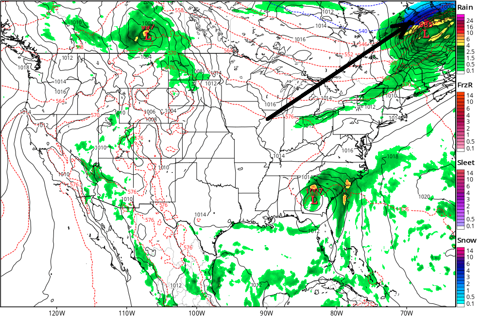
Let's lay down the precedence early, eh ? 150 hour 18z GFS with a full on wrap back CCB blizzard occurring eastern Ontario, replete with a 974 mb bomb ... on the same chart ( though thousands of miles away of course) there is Dorian lurking interior SE... That's pretty awesome man -
-
What do we know about that HMON model ? It's clearly some form or another of a meso model, but I don't have much experience with using it as a prediction tool. The 12z run took a strong Cat 4 across the northern borrows of Miami - pretty much exactly in a fashion I feared might happen yesterday when it appeared then a sharper west turn and farther south trajectory could unfold - reasoning contained... It might be notable that a lot of guidance has been edging left, too. Oper. Euro and so forth.
-
Sandy's modeled trajectory was scheduled to do something similar to that EPS cluster and we all know that it wound up taking the southern route.. just sayn' No analog per se, but sometimes it's hard to imagine thing and maybe that would help -
-
Good ... Harv and I compared notes years ago and came to the same conclusion that the best winters in either ENSO regime are non-trustworthy inconsistent outliers; we are far better off taking our chances in the aggregate which showed a bias skewed snow/cold-positive during neutral ENSO years. And by neutral we mean (+)(-) .5 SD That, combined with super set of longer termed teleconnectors flagging increasing odds for -EPO's ... that's probably the ball game. It's probably also why the Farmer's Almanac has suddenly began showing better accuracy in the last two decades because their "top secret method?" They simply started using the same shit ... not whatever leaped to suppositional guess work mind base upon the squirrel testicle method they were using before... In any case ... if anyone gives a ratz left one ..they've gone and lit up mass-media headlines with a cryo dystopia for this year. Just sayn' Too bad that's not the whole score, however. Sorry - but I am highly confident in the disruption of climate wind patterning and R-wave configuration tendencies as those changes are rooted in climate change, and expansion of the Hadely Cell into the Ferrel latitudes. I began harping about this five or so years ago, when I personally noticed these wind anomaly oddities... They seem to pervasively rule cold season base-lines in either warm or cool ENSOs... and well.. it turns out I wasn't the only one suspecting this...blah blah. But the point is, that changes the landscape a little compared to say ... 50 years ago. If were up to the climate then, we'd be golden with a nadir solar on top of the AMO/PDO cycles, on top of a neutral enso... my god. Don't know about all that mapped over big ballz Hadley disruption though - Still, seein' as GW isn't going anywhere ... I think I'd rather have the former in play - at least ya got a chance that way.. Fast flow and quick cold warm interludes and active storm tracks...
-
Well ... yet another school, if it's been that long and persistent, it should be climate norm fixing and the user should have grown accustomed, sans any expectations otherwise. Finally, after said user moves away to a far away land the region they've given up on and abandons returns to its previous dynamic - ...until such time as a return for a visit of course.
-
Meteorological summer ends in two days... whence autumn begins. Most around in this social media depot know this - just sayn' Here is the first real shot across the bow air mass ...though we've seen better; this one is deep enough. I think it fitting in an symbolic sort of way, that it is latched on to a rapidly transitioning "Dorian" - subjective as it may be ..this is when where/if summer's "back breaks"
-
Yeah..looks on IR like the NAM's old bias is coming back to haunt it - we warned of this ...that the NAM sometimes bias too far W-N in the western Atlantic. The axis/conduit is setting up 50 or so mi E of the NAM's modeled trajectory from earlier runs, and that's going to probably result in strafing lighter showers ...while perhaps the Cape gets clipped... It may fill in back west, but that IR appears to expose where the convergence is..
-
Expansion in size is a slam dunk... In fact, I was just noticing the extraordinarily massive spacial layout in west Atlantic, N and NE of Dorian, that as modeled is setting up a truly massive low level easterly anomaly. Given what is happening along with deep layer ridge pulsation during Dorian quasi hook back west ( SW of NS ) that combination of those two factors really just creates a particularly massive region conducive to cyclogenesis spread out over the entire region off the eastern Seaboard... Sandy did something similar but this is not to be consider an analog. Expanding in size and intensify. I could see this having a tendency to generate an outer eye-wall given to this totality of events, but that's just because if the circulation grows immense that tends to happen. EWR's are not well understood... The idea of involving more of S. Florida in surge is predicated on the assumption that Dorian does indeed "synergistically" feedback with strong systems in light steering environment. Since Dorian appears slated to both destinies... I just thought it prudent to mention - but it's not actually modeled to do so. As is, a trajectory as planned put S. Florida/Miami most likely in a N freshening breeze that starts to go storm force in a NW or off-shore component, which of course is a different impact scenario altogether.
-
Get used to that ...
-
Concerned about Miami ... Here's the deal - Dorian is likely to exceed expectations for intensity guidance. I've just seen this kind of beat before...where the models don't even initialize a system beyond depression, when it reality it's nearing hurrican strength ...yet they still collectively suggest near rapid intensification is plausible despite the weak bias out of the gate ( 12z suite). It's moving up into a region that is going to be nothing but improving for TC structure/genesis. It seems the models are tapping into this latter circumstance proficiently enough, but are not correctly accessing the inertia Dorian already had established. That is troublesome... But mostly, it is the excessive thermal cline integration of ocean heat content it is moving toward, combine with superior shear - lack there off - that should have folks' attention. The reason this sticks Miami out like a sore thumb - despite the present concensus N of that latitude, is because strong/strengthening hurricanes gaining size, can synergistically enhance resistance to polarward motion because they "create their own environment." Basically what is taking place when that happens is ... the outflow ring of the cyclone begins to elevate surface pressure...as well as breaks down steering fields on the polarward size of the cyclone, and the tracks can sometimes bend back west when that happens. It may not be statistically entirely obvious that is what is happening, either, because of the surrounding synoptics are strong enough those forcing will damp the effect out - it's more like an effectiveness when other factors are relatively negligible, the cane will "moat" its self off/tend to do so.. I see Dorian moving into an environment of superior development, that is breaking down synoptically ...which might render it to a west bump out there in time. Something to think about. It's a big maybe and not a prediction... but you do have a bomb potentially hear, and one moving into temporarily induced deeper layer COL look to the troposphere, and I could see that do weird things.
-
Man... I'll tell yeah... sea-level rise is already becoming a management problem in Miami at times of 'fair-weather' high tides. that would be bad
-
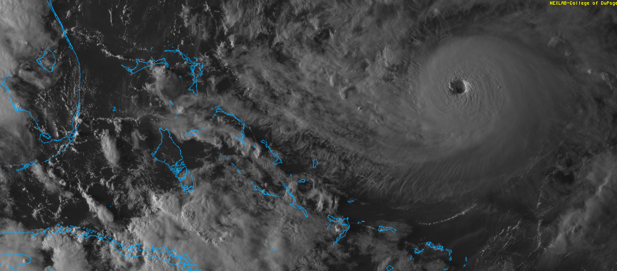
looks like an eye on last couple of rad scans...
-
What's peculiar to me is that the entire suite of various Global numerical models did not initialize Dorian very well on the 12z guidance cycle ... yet, they all take it through robust strengthening over a 24 to 36 hour period beginning pretty much now through tomorrow night. I dunno if there's much merit to the following thinking but that "seems" sort of dire to me - as in ...this means that an even deeper/structurally evolved entity entering that same favorable domain space ... might attain a status that exceeds the models by the time we get to that D4/5 window and this is knocking on the door ...
-
Fwiw -the GEF -based NAM numbers have been elevating and in fact, are positive in the initialization as of last night. They are forecasting a brief dip back to neutral or perhaps modestly negative SD, before an even more robustly positive modality out toward week two. This observation of reversing pressure patterns is probably related to that - I haven't see then EPS rendition, but prognostics going back some ten days began to suggest that the annular mode may flip back then. I suggested that it might alleviate the melt rate ... slowing it down some. Heh, it may just rescue 2019 from tapping 2012 on the shoulder.
-
Wow, "... The NHC foreast is more aggressive than the previous one, and brings Dorian to category 3 intensity by the end of the period. This forecast very closely follows the intensity consensus, the HCCA model, and the SHIPS guidance...." Although, I have noticed a tendency by NHC to 'enhance wording' if not biasing toward more intensity when these TCs start nearing civility - probably for the better PR -wise. I mean, it's been a dearthy season of sitcom television and iPhone distractions. Hard to image after Maria and so forth that society would be complacent, but that happens. Short memories. Not to mention, these sort of ephemeral natural disasters are obscuring these days behind the growing specter of GW ... Still, they have the guidance and it's ligit - either way. That region near the Bahamas - as modeled in means from multiple sourcing - looks superb for strengthening.