

Typhoon Tip
-
Posts
40,602 -
Joined
-
Last visited
Content Type
Profiles
Blogs
Forums
American Weather
Media Demo
Store
Gallery
Everything posted by Typhoon Tip
-
I have no idea if ur kidding here or not... but ...no just in case that's not teasing - it's "how you get it done" - it's a good example - I said nothing about whether that happens or not. just sayn'
-
Are your sure ... denuding the cape of all infrastructure may mean a whole winter without OES updates - j/k James
-
mmm... nope. Tease requires it were ever suggested otherwise - ...the "crowd noise" may have tenor'ed in such a way that that allowed people to get carried away in hope ( not atypical for the obsessive "lensing" that goes on in here ) - or, the interpretation was just off period. When either happens ... reality loses the battle. Either way, the models have never made this a threat here ...not really.. and the surrounding pattern didn't/doesn't really support it either.
-
Now this is how you get it done ... Negative anomaly NW/ positive anomaly NE... 'cane has no other choice - the only problem here is... it's 370 hours away
-
Well ...yeah, and in that same spirit of "semantic fairness" ... the rise in the NAM hasn't been exactly overwhelmingly coherent... The lay-folk web-access site over CPC has it more like languidly elevating beginning two weeks ago ... finally succeeding at some point over the next 10 days. So, yeah. It's not a hugely convincing modality as you/we can see. Nevertheless...some slowing in melt rates is plausibly related. The thing is, the Arctic is sensitive to phase changes because of physics to put it bluntly. The thermal tolerance for ice->water->ice is narrow. Such that subtle variations in thermal contribution may have a seemingly larger proportionate response than one might think or be aware, if we're talking about some hypothetical formula of ( sun + dark vs ice covered albedo ocean surface + salinity variance + 1°C ) ... alter any one of these variables and the system presence a change, but if more than one of them gets altered that significance hockey-sticks in a real hurry... and so on... However the real equation of environmental factors that determines ice retention in the summer really works... we do know that the system is sensi ... So I find it intriguing that the GEFs begin signaling a relaxed negative Annular mode and then a week to two weeks later ...monitoring showed slowing... That doesn't seem like coincidence? But you and I are not parked out on the ice cap in a research hut either.
-
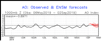
Anchorage's Record-Breaking Summer of 2019
Typhoon Tip replied to donsutherland1's topic in Climate Change
What really needs to be done is a deeper statistical analysis of past -AO summers. A good start; of the three 'hot months,' June, July, and August, when ever the three averaged negative in the Northern Annual Mode, what were the temperature anomaly distributions those years, both as scalar values, but also relative to the oscillation's SD curves. That kind of analysis might begin to expose a secondary trend ... revealing at least the plausibility of systemic change ( the elephant in the room .. notwithstanding), change too often lost in the din of climate noise. For example, suppose there was a -.5 SD mean in the AO in 1955, and the hemispheric temperatures were X. Then, in 2019, there was a -.5 SD mean, and the hemispheric temperatures were Z ... ( X - Z ) = some positive or negative value that in fairness, may not mean much? However... if this were expanded to a bigger comparative population, such that utilizing (x̄ - ȳ), ... where (y1+ y2+ ... + yn)/n = ȳ and the same for x̄ ... if the result equaled a positive number, that is a better finger-print for actual change.. I'm sure this sort of number juggling is being performed everywhere there is a reputable scientific process focused in environmental/atmospheric research/problem solving, but for some reason, I haven't found any published research that specialized in a relative AO to temperature anomaly distribution approach like that ... as a 2ndary precipitant study that might help to crystalize an image through the obfuscating blur of anomalies ( often used to hide truths and lies eh hm ). Primer: ... Negative NAMs correlate with warm temperature anomalies above the (*) 60th parallel. During those periods, (**) cool temperatures tend to occur below the 60th parallel, known as mid latitudes. Naturally, this overall pattern/distribution of temperature anomalies above and below the 60th parallel ... reverses during positive Annular Modes. ( * that ~ demarcation of latitude around the hemisphere does not take into account topographical/geologic imposing variances, and also, fluctuates higher and lower in latitude depending upon the season). ( ** relative to normal AND "pattern" ...a latter distinction often lost and/or strategically elided in efforts of deniers, as well as less learned in general. Relativity matters... a warm pattern may be so warm in 1900, and that same pattern may be cooler(warmer) at another time and space of different geological/environmental arena, a.k.a., the European heat waves now, versus similar pattern manifestation back whence). This has been a rather robustly +AO(NAM) summer. The Alaskan warm summer ... really should be compared to past positive annular mode summers, and also, other northern latitude/geographies around the hemisphere compared. Intuitively ...this is almost tongue-in-cheek and anyone objective has a pretty solid idea what the results are likely to look like ...Oh, some value of positive across the board, where -1 SD summer ins 1890' did not produce the same wamrth as this year...and so forth, but, taking a study through the arithmetic caries more weight for everyone save the eerily growing numbers of population that as an entirely separate and sociological concern, have come under the impression that is okay to say and act in adversarial 'no' in the face of Universal fact(s), that the right to do so is merely enough to refute the reality the do not want to accept. Very recently ( spanning the last two weeks ) the mode has been relaxing toward neutral/positive, and is forecast to continue to do so into September. This is just a heads up; it's an intra seasonal ...at times, intra-weekly time-scale teleconnector, so this is not a statement/intention for seasonal forecast. -
I haven't been a part of this conversation stream recently so pardon if this is more at obtrusive ... It might ( or not ) be worth noting that the GEFs have been elevating the mode of the NAM since ~ mid August. In a vacuum, that putts the "had been forecast" part of this bold statement in question for me. As we know, a positive 'Annular Mode reverses the temperature anomaly correlations and would result/conducive to better ice retention. This is purely linear-statistical discussion point, however, and does not consider the bevy of other environmental factors that "synergistically" can also effect melt rates ...such as salinity variance and momentum, dark sea vs albedo surface absorption of solar...etc etc etc... Nonetheless, some of the graphical slowing in recent 10 days does actually fit that GEFs modality of the NAM in at least conceptual acceptance -
-
Nice try at reverse psychology James - ..solid A for effort here
-
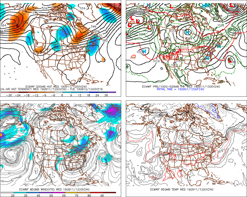
The S/W mechanics slated to time the alley-oop capture of Dorian won't be coming on board into the denser/realized sounding domain until this time tomorrow. Subsequently ...depending upon that system's mechanical power will have a bearing on how the flow tips more S-N, or remains more longitudinally biased along and off the Mid Atlantic. It's a sensi interaction anyway, but the stakes are high; we wouldn't need helluva lot more to get a left'er track N of the Mid Atlantic to materialize... Right now I'd side against that? but it's also preclusively moronic to suggest a stronger relay off the Pac can't take place ... It's popular to roll-eyes and play that defensive game like you're not really hoping that happens ... and forcing an overt conservative facade, but for those who are intelligent, they know it's something that should be monitored. It's interesting because this is a predicament more akin to extra-tropical cyclogenesis proficiencies in the winter that we oft need contend with when we have S/W rollin' over shallow long wave amplitudes - such as this.. But only here, we're trying to capture scenario.
-
These are some of my favorite situations in the "weather as a spectator's sport" engagement. Watching others contemplate how they get to get this or that, when the reality is ... they most likely get nothing - wah wah wahhh. This may very well go down in history as a Great Bahama/Grand Abaco deal, with a ginormous, historically impactful Media headline gale for everywhere else... But, hey, CNN sure made their money off this thing, huh - It seems to me this system has stalled nearly stationary ...doing the thing the models had predicted - pretty damn amazing we have the tech these days to be so dependably reliant. However, that stall coordinate may be skewed E of where the consensus had it ... Perhaps only talking 20 or 30 clicks, but assuming when motion resumes and is as such along the anticipated NW to NNW drift before inevitably accelerating N-NE .. .all that, it seems to intuit a chance for an E adjustment. heh... 12z models coming now so we'll see... Also, the cloud tops over/of the circumvallate have slightly warmed the last couple of hours, and there some subtle signs the eye is more ragged.. I mentioned earlier it would be unlikely for Dorian to endure at those magnificent scales of structure; perhaps we're see some of that.. We may have a Cat 1/2 hurricane climbing the ladder by this time tomorrow?
-
I think it unlikely Dorian will continue to endure with the same structural integrity as indicated in the 5 am NHC advisory. (165 mph and 916 mb of central pressure) Over the course of the day ... it quite possible Dorian will become increasingly victimized by its own impact to the environment in which it depends. Interestingly metaphoric, too ... as hurricanes are a lot like Humanity in that regard - they both must keep moving and exploring new resources of/for energy lest they fester and rot in one place for having profligately chewed through their resources. interesting - I realize the impertinent jest of a weakening Dorian must come along as a disappointment equal in proportion to the specter of the bomb its self ... But, for those who privately covet a fantasy where Dorian drills a hole completely thru to the core of the Earth... causing the planet to fracture and calve into two distinct pieces that go on to finally just disintegrate into a new asteroid belt, the reality is, the cyclone is nearly stationary over a region where the sea slopes deeply on the N side of Grand Bahama and Great Abaco. That steeper, deeper incline probably means cooler water plumb is accessing due to upwelling/ turbulent overturning etc. We'll "sea" how it goes but I bet this thing has maxed -
-
Just thinking back whence .... as little as two weeks ago, how quiet the tropical Atlantic was. Some observationally sensitive designations to date, otherwise ... at the time rendered completely silent. Posts were matriculating in about the year without a season - if not explicitly stated, the tenor certainly palpable. Now, we have this Category 5 bomb and a constellation of other Invests between the GOM and Cape Verdi... It's not just the Atlantic, either. The western Pacific is suddenly bubbling with Invests, too... It's almost like some phenomenon must have passed over the whole planetary troposphere and proverbially uncapped it everywhere, simultaneously.
-
Semblance of a double eye wall... ERC nearing ? In any case, one must wonder what the status of Great Abaco island and Grand Bahama will look like when the sun rises over the aftermath ... days from now. I wonder if some of those cays might get denuded down to high tide sandbars..
-
People have to be able to vote for whom ever in the f they want - but should also be culpable
-
Yah... but I'd like to get this over with because I edge my belief on the side of r-wave residence and that 45 to 90 day thing... If we roll back into a warm pattern... we time a nutty November - which is right on top of my personal druthers. Who's with me! Can be 70 to 90 through halloween for all I care - if it gets cold before then it can't/won't last and in all likelihood the law of balancing anomalies is a cosmic dildo in December if it does. f-that
-
It's amazing how the Euro keeps trying to bring winter across the country in the extended...
-
Dorian's phase transition to extratropical is nothing shy of extraordinary ! It may enough be simultaneously both for several hours, with such an unusually hot, warm secluded core surrounded, by a rampart of baroclinic dynamics...
-
Well... I'll take a look - is if my opinion matters..heh. But, "if" the Euro indeed is/has trended west ...that may not be a trend that is final. We are on the D4/5 temporal relay out there between Hatteras and Cape Cod...which is where/when the Lakes amplitude in the westerlies' critical system interaction details will be occurring, details that are very sensitive to minute perturbations that cannot possibly be assessed at this time... That's all code for yeah... may be worth it to watch. But I wouldn't bust out the dystopian lootion and most towels just yet, either.
-
That may not be entiiirely correct I'm waitin' on the Euro... If the GFS is right, this is probably one of the more costly devastating events in U.S. history. It tries to maintain upper tier power post land interaction as it then rolls up the eastern seaboard on the beach the whole way to Cape Hatteras .. a considerable tick west of priors. I mentioned earlier that the Euro run may be telling as to how much Dorian interacts with that trough in the Lakes - that's going to be key in the cyclones polarward behavior as it stands now... Canadian takes Dorion along a coastal scraping ( west adjusted...) from the central Penn. of Fl, implicating a mincemeat stewing of (natural ecology + man made obliteration)/2 down there, but then a more pallid version but problematic nonetheless all the way to Cape Cod... just missing SE but probably close enough that surf/tide may be an issue - unknown...
-
Mm... Interesting. a "long time lurker" without publishing? or, B, a new exposure to this micro- zeitgeist and therefore green to the particular, more important, peculiar, social-media group... If the former, you should know better ( by now ) than to level a responsible, compassionate resolve for the well-fair of others at this particular group of return concentrated dystopian weirdos. Any reduction in the implication of any kind of Dorian-esque specter for that matter, will not be tolerated. I agree though... There's probably already catastrophic x-y-z happening to a-b-c on the Cays and Islands down there already ... but if we can mitigate beyond that by having Dorian's worst impact on the proper U.S. being drug -withdraw symptoms by said dystopian lusters, we're far better off. That way we may not have to also bear the equally powerful winds of AGW'ing's tie-in causality that's already on mass-media's drafting boards, too -
-
Can you imagine if Dorian just circular-sanded ( formulate sound of power tool in head while reading this ...) the entire Grand Bahama island down to a sandbar -
-
Some notables... 185 mph/ 911 mb ...
-
Seriously though .. the timing of Dorian's 'would-be' trough interaction with the westerlies' amplitude scheduled into the Lakes technically begins ~ 4 days from this 12z cycle. Considering the source, the operational GFS, that's only moderately confidence instilling - I'd say if the Euro starts sniffing out a closer pass that is coherently due to having a stronger trough incursion into the western OV longitudes on it's rendition of D4/5, otherwise ... it's just the GFS being the GFS. The problem is... in baser concept that trough is too flat and longitudinally oriented...such that when Dorian gets anywhere closer to ... roughly the VA Capes longitudes it should already be turning NE/ENE on a London trajectory that would put a Boeing Air Bus in envy - These models that are continuing to lift Dorian "tantalizingly" closer to eastern New England and NS appear to be doing so too much relative to that "flat" character of the open wave tough structure. But, that could be rendered moot either way if said trough gets spatially more amplified ( i.e., N-S meridian flow ), which unfortunately cannot be ruled out absolutely at this time range - but the Euro is getting ready to cross into it's wheel-house ...hence the sniffing -
-
HA HA HA toldya
-
My guess is it maxes at 205 ...central pressure of 882 mb.... Then, turns N and bottle rockets to Montreal, Quebec with such rapidity as to make it the first TC ever to succeed the 40th parallel as a Category 5 hurricane - ...Upon reanalysis, it becomes incontrovertibly necessary to redesignate, "HURRICANE JAMES" ...


